Acknowledgments
We gratefully acknowledge the officers and crew of the R/V ALBATROSS IV for their support. Their devotion to duty helped make this cruise a success.
This report was prepared by John Sibunka, David Mountain, Peter Wiebe, Maria Casas and Charles Miller with assistance from colleagues in the scientific party. This cruise was sponsored by the National Science Foundation and the National Oceanographic and Atmospheric Administration.
TABLE OF CONTENTS
Purpose of the Cruise
Cruise Narrative
Individual Reports:
Hydrography
Zooplankton and Ichthyoplankton studies based on Bongo and MOCNESS tows:
Preliminary Summary of Zooplankton Findings
Preliminary Summary of Ichthyoplankton Findings
Preliminary Summary of the 10-m2 MOCNESS samples
Observations of Calanus finmarchicus over and around Georges Bank, January 1998
High Frequency Acoustics
Microzooplankton Analysis
Drifter Deployments
Shipboard ADCP (Acoustic Doppler Current Profiler) Measurements
Personnel List
Scientific
ALBATROSS IV Officers and Crew
Appendix 1. Data inventory - List of Underway and station Activities
Appendix 2. CTD Plots and Compressed Listings Of the Data
Purpose of the Cruise
Six broadscale surveys are part of the 1998 U.S. GLOBEC Georges Bank Program. These six broadscale surveys are conducted monthly from January to June to monitor the changing biological and physical status in the Georges Bank ecosystem. The first cruise in this series was aboard R/V ALBATROSS IV (AL 98-01, 7-19 January 1998). The principle objectives of the cruise were to:
(1) determine the distribution and abundance of the ichthyoplankton and zooplankton community on the Bank and in adjacent Gulf of Maine and slope waters. Emphasis was on target fish (eggs, larval and juvenile cod and haddock) and copepod species (all stages of Calanus finmarchicus and Pseudocalanus sp.) and their predators and prey.
(2) provide systematic collections of larval and juvenile cod and haddock for age and growth estimates.
(3) collect individuals of Calanus and the euphausiid, Meganyctiphanes norvegica, for population genetics studies.
(4) conduct lipid biochemical and morphological studies of Calanus finmarchicus.
(5) conduct a hydrographic survey of the Bank.
(6) conduct acoustic mapping of the plankton along the tracklines between stations using a high frequency echo sounder deployed in body.
(7) map the Bank wide velocity field using an Acoustic Doppler Current Profiler (ADCP).
(8) deploy drifting buoys to make Lagrangian measurements of the currents.
In order to obtain uniform bank-wide coverage, 41 predetermined "standard" stations and 40 "intermediate bongo" stations were scheduled for this survey. During this cruise 40 standard stations were occupied and 35 bongo stations completed. The entire Bank was surveyed, including the portion in Canadian waters (Figure 1).
The 41 Standard stations were assigned a priority code number (from 1-4) which reflected the equipment used on a given station. Priority stations assigned code 1 or 2 were "full stations" with "high priority" , and stations assigned code 3 or 4 were "partial stations" and designated "low priority". The intermediate bongo stations were considered to have a lower priority (i.e. priority code number 5) than the 41 standard stations.
Survey operations were a combination of both underway and station activities. The ship's ADCP unit was used to make continuous measurements of the water current profile under the ship, in
Reserved for Figure 1
order to construct the current field over the whole Bank. This data will be used to help in the interpretation of all the other observations made on the cruise. The along track operation consisted of high frequency acoustic measurements of the volume backscatter and nekton throughout the water column and surface measurements of temperature and fluorescence. Navigation information, meteorological data, and sea surface salinity and temperature were recorded by the vessel's computer system.
At full stations an oblique plankton tow from surface to near bottom was made with a bongo sampler along with a real-time CTD attached to the towing wire. A large volume zooplankton pumping system was use to sample the water column. A Neil Brown Mark V CTD-fluorometer unit was used to characterize the water column. Niskin bottles attached to a rosette were used to collect water samples at selected depths for biological and chemical analysis. Water samples were processed on shipboard for chlorophyll-a and phaeopigment concentrations. Samples for phytoplankton species identification, cell count, and spatial distribution will be analyzed ashore. Water was also drawn for microzooplankton analysis, salinity determination and H218O/H216O isotope concentration analysis. A 1-m2 MOCNESS (Multiple Opening Closing Net Environmental Sampling System) was towed obliquely from surface to near bottom cycling twice to make vertically stratified collections of zooplankton with both 335 �m mesh and 150 �m mesh nets, and to make collections of fish larvae with 335 �m mesh nets. A 10-m2 MOCNESS fitted with 3.0-mm mesh nets was towed obliquely from surface to near bottom to make vertically stratified collections of larger predators on target species. At partial stations, a bongo tow, a Neil Brown MarkV CTD cast, and 1-m2 MOCNESS tow were made. At the intermediate bongo stations, a bongo sampler and real-time CTD were towed obliquely from surface to near bottom. At selected stations, the real-time CTD and a Niskin bottle cast were made for calibration purposes. A summary of sampling events that occurred during this cruise is in Appendix 1.
Cruise Narrative
In this section, reference made to station numbers refers to standard station number. The intermediate bongo tows between stations were generally completed. Bongo tows that were not done were noted in the narrative. Vessel speed did not exceed 7.5 kts while towing the acoustic fish between stations.
5 January
The cruise was initially scheduled to depart at 1400 hrs. However, sailing was canceled and rescheduled for 1000 hrs on 6 January. The reason for this delay was that the ship had just completed an in-port dockside repair period and several repairs were not finished. Also, vessel personnel also were testing various systems for proper operation. The weather conditions in the morning were pleasant with mild air temperatures and calm winds. Fog then developed during the afternoon hours.
6 January
The sailing time was changed from 1000 to1400 hrs, canceled, and rescheduled for 1000 hrs on 7 January. The main reason for the delay was that the ship's sanitary system was still not operative. The scientific party used the dockside time for setting up, checking out and securing the various types of scientific equipment on board. The weather conditions were foggy with intermittent light rain and mild air temperatures.
Because of survey time already lost, both the North East Fisheries Center (NEFSC) and the Atlantic Marine Center (AMC) allowed the GLOBEC program additional vessel time for survey work if the time was needed.
7 January
The scheduled departure of 1000 hrs was delayed due to a mechanical problem of insufficient air supply to the ship's main engines. The repairs were completed and R/V ALBATROSS IV departed NEFSC Woods Hole, Massachusetts, at 1818 hrs. Running time to the first station was about twelve hours. A scientific and ship's meeting was held for the scientific party. The weather conditions were mild with periods of rain and calm winds.
8 January
Stations completed were 1, 2, 41, and 3. Survey operations began on 0600 hrs at station 1. At stations 1 and 2 the 1-m2 MOCNESS computer did not have navigational input into the program. This was resolved by station 41. At station 3, the 10-m2 MOCNESS tow was aborted. The communication signal from the 10-m2 MOCNESS to the computer program was lost just prior to deployment. This problem was attributed to the electric termination on the towing wire. A retermination was done by the vessel's Electronic Technicians. The E-O cable to the 1-m2 MOCNESS was also replaced. The weather conditions began to deteriorate as a southwest wind had increased to 25 kts and the seas began to build late in the day.
9 January
Stations completed were 4 (no intermediate bongo between stations 4 and 5), 5 (a Neil Brown MarkV CTD cast only), 6 and 7. On station 4, three of the five nets on the 10-m2 MOCNESS came back damaged with tears of varying lengths. These nets were previously used and had been sent to a commercial company for refurbishment prior to this cruise. It was found upon examination of the net damage that the new support ropes that run the length of the net at each of the four corners from the mouth opening to the cod end were only lashed to the mesh and not secured to the fabric collars and support rings. Some of the mesh material itself appeared weak. The nets were also separating where the mesh is sewn to the net collar. Repairs were carried out by scientific personnel and members from the deck department on watch.
About mid morning a leak developed in a pipe fitting which supplies sea water to the 01 deck sanitary systems. The damaged pipe was located in the overhead of the passageway between the port and starboard laboratories. The repairs were preformed by personnel from the engineering department. Repair to this leak took several hours, and during this time the vessel's sea water system was shut off. As a result there was not any sea water available on deck to wash towed nets with, therefore station activity was limited to CTD casts only while the damaged pipe was repaired. In an attempt to obtain sea water for rinsing nets, the ship's chief boatswain supplied a small submersible pump for this task. The submersible pump was satisfactorily employed until repairs to the sea water pipe was completed and the vessel's salt water system was again operative later in the day. Also, a mechanical problem had also developed about midnight with the vessel's sanitary system. This system was of limited use during the day until repairs were finished by personnel from the engineering department. At the completion of the Neil Brown MarkV CTD cast on station 6, the conductivity sensor cell was found to be damaged. Repairs to the cell are not possible at sea. However, the rest of the Neil Brown MarkV CTD was operative and useable. Salinity measurements for the remainder of this cruise were obtained from the Seabird Electronics Seacat deployed on station. On station 7, net # 4 on the 1-m2 MOCNESS was damaged and replaced. At the completion of the 10-m2 MOCNESS tow at this station, three nets were retrieved damaged. Two of the nets were repaired by the scientific party and one net was removed from the frame as damage to this net was extensive. As there are not further spare nets on board, the 10-m2 MOCNESS was now fitted with four nets. The weather conditions during the morning hours had improved. Winds from the southwest had diminished to15-20 kts along with subsiding seas throughout the rest of the day.
10 January
Stations completed were 8, 9 (no intermediate bongo between stations 9and 10), 10 (a Neil Brown MarkV CTD cast only at station10; no intermediate bongo between stations 9 and 10), 11 and 12. On station 9 at the completion of the10-m2 MOCNESS tow, two nets were retrieved damaged. One net was repaired by the scientific party and one net had to be removed as damage was extensive. The 10-m2 MOCNESS was now fitted with only three nets. A problem was noticed with the conductor cable on the boom winch. The cable strands above the termination were found to be tuning against the lay of the wire. A 50 meter section of wire was cut off and the ship's Electrical Technicians reterminated the cable. During the retermination of the cable (about 3 hrs) the 1-m2 MOCNESS sampler and the bongo net could not be deployed for station work. All station operations were resumed on station 11. At station 10, the Seabird Electronics Seacat (used in archive mode) was attached to the wire above the Neil Brown MarkV CTD for salinity determination during the cast. Weather conditions were fair, with winds from the northwest 15-20 kts.
11 January
Stations completed were 13, 14, 15, 16 and 17. Routine survey operations. Weather conditions were spring like with warm air temperatures, sunny skies, and winds northwest at 5 kts. Conditions during the evening were similar with a clear night sky and calm seas.
12 January
Stations completed were 18, 19, 20, 21 and 22. Routine survey operations. On station 20 at the completion of the10-m2 MOCNESS tow, two nets were retrieved damaged. Repairs were made by the scientific party. Weather conditions were again spring like, with mild air temperatures, calm seas, and winds from the north about 3 kts.
13 January
Stations completed were 23, 24, 25, 39 and 26 (no 10-m2 MOCNESS tow). On station 23 at the completion of the10-m2 MOCNESS tow, two nets were retrieved damaged. Repairs were made by the scientific party. To repair one net, a section of mesh was cut from one of the previously damaged (and removed) nets and sewn into the damaged net on the 10-m2 MOCNESS frame. At the completion of the 10-m2 MOCNESS tow on station 39, a net was retrieved with extensive damage. This net was replaced with a previously removed net that was repaired by scientific personnel during the cruise. At station 26 the 1-m2 MOCNESS tow was canceled and a bongo tow was substituted due to adverse sea conditions. Weather conditions deteriorated as the day progressed. During the morning, the skies were sunny and winds were from the south at about 10 kts. At noon, skies were cloudy, and the winds from the south had increased to 25 kts. During the evening the southerly winds had increased to 25 kts and then shifted to the northwest at 30-35+ kts (gale force) with a rise in sea state.
14 January
Stations completed were 27 (two bongo tows and pump only), 28 (two bongo tows only; no intermediate bongo between stations 28 and 29) and 29 (no 10-m2 MOCNESS tow). Because of gale force winds and high seas, station 27 was limited to only two bongo tows and a Pacer high-volume pump cast. While en route to station 29 the Pacer high-volume pump, which was lashed to the port rail, was damaged by a series of seas washing aboard the ship. The PVC manifold assembly was broken in two places. This assembly was brought into the main lab for repair. This was carried out by scientific personnel by use of an epoxy cement obtained from the vessel's engineering department. By 0600 hrs, the gale had increased such that the ship ceased scientific operations and the weather decks were secured. By late afternoon the gale had slightly diminished so that two bongo tows were made at station 28. By 1800 hrs the weather conditions had moderated to allow all scheduled activity at station 29 except the deployment of the 10-m2 MOCNESS. Weather conditions during the early morning had deteriorated to gale force west winds of 40-50 kts and accompanying high seas. At late morning the winds began to subside and by evening the winds shifted to the northwest and had diminished to about 25 kts. The air temperature dropped to below freezing in the evening and night hours.
15 January
Stations completed were 30, 31, 32 and 33. The weather forecast was for gale to storm force winds developing today for the survey area and through tomorrow. Another gale system was forecast to effect the survey waters Sunday. Based on this weather forecast, it was decided not to go to station 40. Instead the remaining survey time would be utilized in the attempt to occupy the remaining stations on the Bank before the ship would have to return to port. On station 30 at the completion of the10-m2 MOCNESS tow, one net was retrieved damaged and removed. The two remaining nets were rearranged sequentially on the frame to facilitate net bar cycling during subsequent deployment of the 10-m2 MOCNESS. On station 32 at the completion of the10-m2 MOCNESS tow, one net was retrieved damaged and repaired. The weather conditions during the early part of the day had abated to northwest winds of 10-15 kts with an accompanying decrease in sea state. By early evening the winds had shifted to the southeast about 15 kts, and were increasing in strength. The weather forecast was for a rapidly intensifying storm system to develop during the next few hours in our area of operation and continue through the next day. The winds for this storm were predicted to veer from the southeast to the northeast and increase to 45-50 kts. Based on this forecast, it was decided to run full speed toward Cape Cod and anchor off Provincetown to wait out this storm. Station 34 was started near the end of the watch and completed shortly after midnight.
16 January
Completed station 34. At 0025 hrs the acoustic fish (Greene Bomber) was brought on deck. The ship was secured for adverse weather and began the 10-11 hr run to Provincetown, Cape Cod, at full speed. At 1100 hrs the vessel was anchored in Cape Cod Bay off Provincetown. Weather conditions when the ship arrived off Provincetown were gale force northeast winds and heavy rain. The weather forecast predicted northeast winds increasing to 50 kts into Saturday (17 January) and diminishing late in the evening of that day. The previously forecasted gale for Sunday (18 January) was canceled.
17 January
Departed anchorage off Provincetown at 1245 hrs. Vessel en route to survey area to resume survey operations. During the transit back to the Bank, the vessel stopped at 1900 hrs to do a 1-m2 MOCNESS tow in the southern portion of Wilkinson Basin. The purpose of this tow was for the collection of Calanus finmarchicus. At the completion of this tow, the ship headed for station 34 to deploy the Greene Bomber, and resume survey operations. By late morning the storm had began to moderate and the weather forecast predicted diminishing winds throughout the remainder of the day. At the station in the southern portion of Wilkinson Basin, the winds had subsided to 25 kts from the north. The seas were still high, but the 1-m2 MOCNESS was able to be fished.
18 January
Completed stations 35, 36, 37, and 38. The vessel arrived back on station 34 at 0145 hrs. A vertical cast with the Seabird Electronics Seacat was made and the Greene Bomber was deployed. At the completion of the 10-m2 MOCNESS tow at station 36, one net was retrieved damaged and removed as the damage was extensive. The 10-m2 MOCNESS was now fitted with only one net. An additional 1-m2 MOCNESS tow was made at station 38 for live specimens of Calanus finmarchicus and Pseudocalanus sp. At the completion of station 38 the Greene bomber was brought on deck and secured and a drifter buoy was deployed at 1941 hrs. A snow squall passed through the area of operation at station 38. As this was the last station for the cruise the ship began the return run back to Woods Hole. The scientific party utilized the time dismantling the MOCNESS samplers and packing scientific equipment and supplies. The weather conditions during the morning were overcast skies with a northeast wind of about 17 kts and subsiding seas. During late afternoon the northeast wind had subsided to 10 kts and station work during this time was accompanied by intermittent periods of rain and/or sleet.
19 January
R/V ALBATROSS IV arrived at the NEFSC Woods Hole, Massachusetts, dock at 0730 hrs and completed cruise AL9801. The survey was extended one day from the initial cruise schedule.
Individual Reports
Hydrography
(David Mountain and Cristina Bascunan)
Objectives:
The primary instrument for collecting hydrographic data on this cruise was a Neil Brown Mark V CTD instrument (MK5), which provides measurements of pressure, temperature, conductivity, fluorescence and light transmission. The MK5 records at a rate of 16 observations per second, and is equipped with a rosette for collecting water samples at selected depths. In addition a Seabird Electronics Seacat model 19 profiling instrument (SBE19 Profiler) was used on each bongo tow to provide depth information during the tow. Pressure, temperature, and salinity observations are recorded twice per second by the Profiler, and represent a second source of hydrographic data.
Operations:
The MK5 was deployed with 6 bottles on the rosette and samples were collected for various investigators. On each MK5 cast, samples were to be collected for oxygen isotope analysis by R. Houghton (LDGO) and a sample was taken at the bottom for calibrating the instrument's conductivity data. Water samples also were taken from three bottles for micro-zooplankton analysis for S. Gallager (WHOI) (see separate report). At "full" stations water samples from three depths were filtered for chlorophyll analysis. The filter papers were frozen for subsequent analysis by D. Townsend (UMaine). At "full" stations surface water samples for phytoplankton species composition also were collected and preserved for J. O'Reilly (NMFS).
The following is a list of the CTD data collected with each of the sampling systems used on the cruise:
Instrument # of Casts
MK5 38
MK5 calibration 7
SBE19/Bongo 76
SBE19 calibration 11
Parameter # of Samples Taken
Oxygen isotope 129
Phytoplankton 15
Chlorophyll 56
Data:
The SBE19 Profiler and the MK5 data were post-processed at sea. The Profiler data were processed using the Seabird manufactured software: DATCNV, ALIGNCTD, BINAVG, DERIVE, ASCIIOUT to produce 1 decibar averaged ascii files. The raw MK5 data files were processed using the manufacturer's software CTDPOST in order to identify bad data scans by "first differencing." The latter program flags any data where the difference between sequential scans of each variable exceed some preset limit. The "Smart Editor" within CTDPOST was then used to interpolate over the flagged values. The cleaned raw data were converted into pressure averaged, pressure centered 1 decibar files using algorithms provided by R. Millard of WHOI, which had been adapted for use with the MK5.
At the end of the seventh MK5 cast (at standard station 6) the conductivity cell was damaged as the instrument was being brought aboard and secured. Conductivity measurements could no longer be made by the instrument. The instrument was deployed at the subsequent stations to collect profiles of temperature, fluorescence and light transmission, and to collect water samples. However, the data from the SBE19 profiler used on the bongo tow at each station became the primary hydrographic (temperature and salinity) for the rest of the cruise.
The locations of hydrographic measurements at standard stations and at the in-between bongo stations are shown in Figure 1. The surface and bottom temperature and salinity distributions are shown in Figures 2 and 4. The anomalies of surface and bottom temperature and salinity (calculated using the NMFS MARMAP hydrographic data set as a reference) are shown in Figures 3 and 5. A stratification index (sigma-t difference from the surface to 30 meters) and the anomaly of this index are shown in Figure 6. The surface and bottom fluorescence distributions are shown in Figure 7. The volume average temperature and salinity of the upper 30 meters were calculated for the Bank as a whole and for the four sub-regions shown in Figure 8. These values are compared with characteristic values that have been calculated from the MARMAP data set for the same areas and calendar days. The volume of Georges Bank water (salinity < 34 psu) was also calculated and compared against the expected values. Profiles of each MK5 CTD cast with a compressed listing of the preliminary data are found in Appendix 2.
The surface salinity distribution (Figure 4a) indicates that the lowest salinities (<32.25) were observed along the southern flank of the Bank and in a small area of the Northeast Peak (standard stations 22 and 23) where values <31.5 were observed in the upper 20m of the water column. The low salinities were also associated with the lowest temperatures (Figure 2a). The implication is that a tongue of Scotian Shelf water resided off the southern edge of the Bank and encroached onto the southern flank. The area of Scotian Shelf water on the Northeast Peak defined by standard stations 22 and 23 did not appear to extend either eastward to Browns Bank or northward to the northern flank of the Bank.
The salinity of the southern half of the Bank was less than that of the northern half (Figures 4a and 8), and may indicate a more subtle contribution of Scotian Shelf water to the whole southern half of the Bank. The north/south difference is indicated well in the temperature and salinity anomaly distributions in Figures 3 and 5
Reserved for Figure 2
Reserved for Figure 3
Reserved for Figure 4
Reserved for Figure 5
Reserved for Figure 6
Reserved for Figure 7
Reserved for Figure 8
The shallow central (or western-central) region of the Bank exhibited the highest fluorescence values (Figure 7). The surface layer (0-30m), bank-wide average fluorescence of 0.6 was about equal to the values for the January cruises in 1996 and 1997.
As to be expected, little stratification was observed except along the southern flank and Northeast Peak where presence of Scotian Shelf water created a low density surface layer (Figure 6).
The first three years of the program have been characterized by a decrease in salinity of the Georges Bank waters from 1995, through 1996 to 1997. Using the values in the northwestern portion of the Bank, to avoid confounding effects of direct Scotian Shelf or Slope Water influence, the salinity in January 1998 with an anomaly of -0.3 (Figure 8) has increased relative to 1997 when the anomalies were -0.5 to -0.8. The implication is that a multi-year period of low salinity, which was evident not only on Georges Bank, but throughout the Gulf of Maine, is waning.
Zooplankton and Ichthyoplankton studies based on Bongo and MOCNESS tows.
(John Sibunka, Maria Casas, Peter Garrahan, Joseph Kane, Stephen Brownell and Riley Young)
Objectives:
(1) Principle objectives of the ichthyoplankton group in the broadscale part of the U.S. GLOBEC Georges Bank Program were to study the composition of the larval fish community on Georges Bank, to define larval fish distribution across the Bank and within the water column, to determine those factors which influence their vertical distribution, and to determine bank-wide versus "Patch-Study" mortality and growth rates. Emphasis in this study is on cod and haddock larvae along with their predators and prey. This study also includes larval distribution and abundance, and age and growth determination. These objectives were implemented through use of bongo net and 1-m2 MOCNESS to make the zooplankton collections.
(2) The primary objective of the zooplankton group was to complete a bank-wide survey of Georges Bank to determine the distribution, abundance, and stage composition of the target species Calanus finmarchicus and Pseudocalanus spp. A second objective was to identify, quantify, and describe the occurrence of abundant non-target species in order to provide a description of the environment occupied by the target species. These objectives were implemented by using the 1-m2 MOCNESS, a vertically discrete, multiple opening and closing net system for sampling copepods and larger zooplankton, and a submersible pump for sampling the small, naupliar stages.
In addition to these objectives, the zooplankton group was responsible for obtaining
subsamples from the 1-m2 MOCNESS hauls for population genetic studies of Pseudocalanus spp. to be completed by Dr. A. Bucklin at the University of New Hampshire.
Methods:
Bongo tows were made with a 0.61-m frame fitted with paired 335 �m mesh nets. A 45 kg ball was attached beneath the bongo frame to depress the sampler. Digital flow meters were suspended in the mouth of each net to determine the volume of water filtered. Tows were made according to standard MARMAP procedures, (i.e., oblique from surface to within five meters of bottom or to a maximum depth of 200 m while maintaining a constant wire angle throughout the tow). Wire payout and retrieval rates were 50 m/min and 20 m/min respectively. These rates were reduced in shallow water (<60 m) to obtain a minimum of a five minute tow or reduced due to adverse weather and sea conditions. A Seabird CTD was attached to the towing wire above the frame to monitor sampling depth in real time mode and to measure and record temperature and salinity. Once back on board, the 335 �m mesh nets were rinsed with seawater into a 330 �m mesh sieve. The contents of one sieve were preserved in 5% formalin and kept for ichthyoplankton species composition, abundance and distribution. The other sample was preserved in 95% ethanol and kept for age and growth analysis of larval fish. The same preservation procedure was followed as for the 1-m2 MOCNESS.
At stations where the 1-m2 MOCNESS system could not be used due to adverse weather conditions, a second bongo tow was made. This frame was fitted with both 335 �m mesh and 200 �m mesh nets. Digital flow meters were suspended in the mouth of each net to determine the volume of water filtered. Tows were made according to standard MARMAP procedures except maximum tow depth was 500 m. Wire payout and retrieval rates were 50 m/min and 20 m/min respectively. The nets were each rinsed with seawater into a corresponding mesh sieve. The 200 �m mesh sample was retained for zooplankton species composition, abundance and distribution, and preserved in 10% formalin. The other sample (335 �m mesh) was kept for molecular population genetic analysis of the copepod, Calanus finmarchicus, and preserved in 95% ethanol. After 24 hours of initial preservation, the alcohol was changed.
The 1-m2 MOCNESS sampler was loaded with ten nets. Nets 1-4 were fitted with 150 �m mesh for the collection of older and larger copepodite and adult stages of the zooplankton. Nets 0, and 5-9 were fitted with 335 �m mesh for zooplankton (nets 0 and 5) and ichthyoplankton (nets 6-9) collection. Tows were double oblique from the surface to within 5 m from the bottom. The maximum tow depth for nets 0, 1 and 5 was 500 m, and for net 6 was 200 m (if net 5 was sampled deeper than 200 m, it was returned up to 200 m and closed). Winch rates for nets 0-5 were 15 m/min and for nets 6-9, 10 m/min. The depth strata sampled were 0-15 m, 15-40 m, 40-100 m, and >100 m. The first (#0) and sixth (#5) nets were integrated hauls. For shallow stations, with only 2 or 3 of the depth strata, not all nets were fished. The contents of nets 0-4 were sieved through 150 �m mesh sieve, subsampled using a 2-L plankton sample splitter if the final biomass volume was too large for one quart jar, and then preserved in 10% formalin. Samples from nets 5-9 were sieved through 330 �m mesh sieve and preserved in 95% ethanol. After 24 hours of initial preservation, the alcohol was changed. The used ethanol was retained for disposal or recycling ashore. At priority 1 and 2 stations and at station 40, 90-ml subsamples from the bottom and surface 150 �m mesh nets were removed and preserved in 10% formalin for Dr. C. Miller (OSU). At priority 1 and 2 stations, 90-ml subsamples from nets 2, 3, and 4 were removed and preserved in 95% ethanol. These samples were collected for Dr. A. Bucklin for population genetic studies to distinguish the Pseudocalanus species found on Georges Bank.
The 10-m2 MOCNESS was initially loaded with five 3.0 mm mesh nets. Tows were oblique from surface to ~10 m from bottom or a maximum depth of 500 m. The same depth strata were sampled as with the 1-m2 MOCNESS. The winch rate for retrieval varied between 5 and 20 m/min depending on the depth stratum. The slow winch rates were used in order to filter at least 4,000-5,000 m3 of water per depth stratum sampled. A stepped oblique tow profile during retrieval was used to achieve this, if needed. Due to the removal of damaged nets from the 10-m2 MOCNESS frame during the cruise, the depth strata sampled was adjusted to accommodate the nets remaining on the frame. When the frame was fitted with four nets, net 1was fished from maximum depth to 40m. With three nets on the frame, net #2 was fished from 40m to surface. When the frame was fitted with two nets, net #1 was fished from maximum depth to surface. With one net on the frame, an oblique tow was made. Catches were sieved through a 330 �m mesh, and preserved in 10% formalin.
The Pacer high-volume pump was used to collect nauplii and younger, smaller copepodite stages of zooplankton. The intake hose was deployed off the port side hydro boom by connecting the suction end, fitted with a 1.7-L Niskin bottle cut in half lengthwise, to the winch wire. The boom winch meter block was zeroed at the surface and the wire out reading was used to determine the depth of the cast. Two 45 kg weights were used to depress the array. Three 30-m sections of 7 cm diameter hose were connected to the pump, allowing the intake hose to attain a maximum depth of approximately 75 m. At shallow stations, the intake hose nozzle was lowered to 3-5 meters off the bottom. Three integrated depth samples were collected with 35 �m mesh nets, sieved through a 30 �m mesh sieve and preserved in 10% formalin. Sampling depths were from the maximum depth to 36 m, 36-11 m, and from 11 m to surface. Before samples were collected, water was diverted from the net and the hose was allowed to flush for 60 seconds. This assured that the zooplankton from the desired strata was obtained. Once at the surface, the intake section was held just below the surface for 60 s. This allowed the water to pass completely through the hose. Wire retrieval rate was approximately 4 m/min. This rate was used to obtain volumes of 500 L per 5 m depth interval sampled.
Additional tows were made with the 1-m2 MOCNESS using only the150 �m mesh nets for collections of Calanus finmarchicus. One tow was made in the southern portion of Wilkinson Basin and the samples preserved according to standard protocol. A tow was also made at station 38 to collect live Calanus finmarchicus for use in the development of an immnuoprobe. The animals caught in the cod end buckets were gently released into gallon plastic jars previously filled with seawater. These jars were kept in a cooler with ice until the vessel returned to port.
Samples Collected by the Zooplankton and Ichthyoplankton Groups:
Gear Tows Number of Samples
1. Bongo nets, 0.61-m 76 tows 73 preserved, 5% formalin
335-�m mesh 76 preserved, EtOH
200-�m mesh 3 preserved,10% formalin
2. MOCNESS, 1-m2 36 tows
150-�m mesh 148 preserved, 10% formalin
335-�m mesh 146 preserved, EtOH
3. MOCNESS, 10-m2 17 tows
3.0-mm mesh 50 preserved, 10% formalin
4. Pump 19 profiles
335-�m mesh 56 preserved, 10% formalin
Preliminary Summary of Zooplankton Findings.
(Maria Casas, Peter Garrahan, and Riley Young)
The dominant copepod for most of Georges Bank was Centropages typicus. Numbers of Calanus finmarchicus were low throughout the southern flank, and only began to increase along the northeast peak and the deeper slope stations north of the Bank. At standard station 29 the majority of C. finmarchicus were at stage C5, implying that their life cycle was somewhat delayed for the time of year.
An interesting observation was that the shelled pteropod, Limacena retroversa, appeared throughout the sampling area in large numbers, unlike last January when they were in very low abundance.
Also, the 'spring' phytoplankton bloom has gotten a head start, as the diatom, Coscinodiscus, appeared in most of the Bank samples in sufficient numbers to make rinsing of the nets and collection of the samples difficult for the finer mesh nets of the 1m2 MOCNESS.
Observations of zooplankton species composition were made at most Standard stations sampled during this cruise. These observations were made from the net #0 samples (335 �m mesh), 1-m2 MOCNESS, unless otherwise stated. Brief descriptions appear below.
Stations 1, 2, and 41 Centropages typicus appears to be the most abundant copepod at these stations followed by Pseudocalanus spp. A mix of life stages were seen. Calanus finmarchicus was seen but it was not very abundant. Other zooplankton seen were the chaetognath, Sagitta elegans, and hyperid amphipods. The diatom Coscinodiscus, was also moderately abundant.
Station 3 Metridia lucens was very abundant at this station with lesser numbers of C. typicus than in the previous station, and a few Calanus. The shelled pteropod, Limacina retroversa, was present, as were amphipods and chaetognaths.
Stations 4 and 6 Typical mix of Georges Bank zooplankton: C. typicus and C. hamatus, Temora longicornis, Pseudocalanus, and C. finmarchicus. Also seen were mysids in abundance, chaetognaths and amphipods in lesser numbers. Coscinodiscus was very abundant here.
Station 7 This off-bank station was composed mainly of M.lucens Pleuromamma spp., C. typicus, and some C. finmarchicus. The finer mesh surface nets also contained Coscinodiscus. Euphausiids and gammerid amphipods were abundant.
Stations 8 and 9 Again C. typicus was the dominant copepod at these stations, together with a moderate number of Pseudocalanus, and a few T. longicornis and M. lucens. A moderate number of male C. finmarchicus were seen at station 9. Coscinodiscus was ever present in the water column.
Station 11, 12, 13, and 14 The same species of copepods were present as in previous stations, with C. typicus being the most abundant. Mysids were seen in fairly large numbers. Coscinodiscus ever present.
Station 15 Copepod concentration was very low at this station. C. typicus was again the dominant copepod. In addition, mysids, shelled pteropods and Coscinodiscus made up the sample.
Station 16 Water column very sparsely inhabited by zooplankton. M.lucens and other off-bank species, together with shrimps, euphausiids, and chaetognaths made up the bulk of the sample.
Station 17 The majority of the sample was made up of C. typicus, with a moderate number of M. lucens, some Clausocalanus spp., and a few C. finmarchicus. Many shelled pteropods were seen as well as some amphipods and chaetognaths. Coscinodiscus ever present.
Stations 18, 20 and 21 The nets came up brown with Coscinodiscus slime. Very hard to work with. Many pteropods were also present in the sample. Some C. finmarchicus were also seen together with the dominant C. typicus.
Stations 22 and 23 Coscinodiscus concentrations down from previous stations. C. finmarchicus more abundant than at any station so far. C. typicus still present but in lesser abundance. Other copepods seen: M. lucens, Clausocalanus spp. and Oithona spp.
Station 39 C. finmarchicus (mostly older stages and adults) was the dominant compepod at this station, with M. lucens in second place. C. typicus were seen in small numbers. Pteropods and Coscinodiscus were abundant in the surface nets.
Station 29 C. finmarchicus was again dominant at this station. Their life cycle was somewhat delayed, most of the animals were stage C5. Other copepods seen: Euchaeta norvegica and E. marina, and M. lucens. Pteropods again seen in the surface nets.
Stations 30, 31, and 32 Typical bank mix of copepods. Back to C. typicus being the dominant copepod in the samples, with some C. hamatus also mixed in. Pseudocalanus spp. was also seen in moderate numbers, as were a small number of T. longicornis. Very few C. finmarchicus. Coscinodiscus seen in the finer mesh nets. Also, chaetognaths and gammerid amphipods in the samples.
Preliminary Summary of Ichthyoplankton Findings.
( John Sibunka, Joseph Kane and Stephen Brownell)
The samples collected at 40 GLOBEC broadscale stations from both the bongo and 1-m2 MOCNESS and from the bongo at the intermediate bongo stations were examined on shipboard for the presence of fish eggs and larvae. The samples were preserved, and observed while in the jar with the aid of a magnifying glass. This was done in an attempt to obtain a qualitative estimate of abundance, distribution, and size range of ichthyoplankton on Georges Bank. The following observations are based on examination of samples in the jars following preservation. The formalin-preserved samples are clearer, and delicate eggs are less likely to collapse as those preserved in ethanol.
Cod (Gadus morhua) and/or Pollock (Pollachius virens):
Only one cod/pollock larva (size 14mm) was observed in the samples collected on the cruise. This larva was caught at station 38 by 1-m2 MOCNESS between 15m and surface. A comparison of the results last January (refer GLOBEC cruise report AL97-01) shows that small numbers of larvae were present throughout the Bank area as opposed to only one occurrence this cruise.
Atlantic herring (Clupea harengus):
Atlantic herring larvae (size range 25-45mm) were collected in small numbers across the western area of Georges Bank. There was not a distinct difference in the size of the larvae collected between stations. At the stations where herring were collected the estimated number of larvae per station ranged from 1 to 20. Most herring larvae numbered less than 6 per station. No Atlantic herring larvae were seen in the samples collected from the central and eastern portion of the Bank.
A comparison of the Atlantic herring larvae catch results of this cruise to the results of the January survey last year (refer GLOBEC cruise report AL97-01) shows that larvae collected this cruise were more concentrated on the western portion of the Bank. Herring larvae last January were found mostly in the central portion of the Bank.
Sand lance (Ammodytes sp.):
Sand lance larvae were intermittently distributed across the Georges Bank survey area. The number of larvae was usually small and the number ranged from 1 to 20 larvae per station. The largest catches, estimated about 100 larvae per station, were collected at the bongo station between station 3 and 4, and at station 4. Sand lance larvae ranged in size from about 10 to 35mm in length. The smaller larvae (size range 10-12mm) were collected at the northwest portion of the Bank. Larger larvae (size range 30-35mm) were not localized, but appeared scattered across the survey area.
A comparison of the sand lance larvae catch results from this cruise to the survey results from last January (refer GLOBEC cruise report AL97-01) shows that both the size range and the distribution of larvae are similar. A large catch of small larvae collected last year may have been the result of a localized hatch as mentioned in the cruise report.
Eggs:
Cod/haddock/pollock eggs were collected in small numbers at only a few stations this cruise. These gadid egg catches occurred from the central to the eastern portion of Georges Bank. In this area of the Bank, gadid eggs were collected in the area encompassing stations 19 to 23. Eggs were again collected in the northwest portion of the Bank in the area between station 36 to 38. The largest estimated catch of 185 eggs occurred at station 19.
A comparison of the gadid egg catches of this cruise to the results observed last January (refer GLOBEC cruise report AL97-01) indicates that spawning has probably just commenced on the Bank. Last year an estimated several thousand eggs were collected at stations occupied on the North East Peak area of Georges Bank. The gadid egg catches of the January cruise in 1996 (refer GLOBEC cruise report EN-276) are similar to the results found on this survey in that only small catches of eggs were reported.
Preliminary Summary of the 10-m2 MOCNESS samples.
(Maria Casas and John Sibunka)
The samples collected from 10-m2 MOCNESS were examined on shipboard for a qualitative estimate of abundance, distribution, and size range of both the invertebrate and the fish community at station. The following observations are based on examination of the samples following preservation.
Standard Station 4, Haul 1:
Ctenophores
Atlantic herring (Clupea harengus)
Standard Station 7, Haul 2:
Ctenophores
Squid (�2cm length)
Hyperid amphipods
Naked pteropods (Clione sp.)
Euphausiids
Decapod shrimp (Crangon)
Jellyfish (bell size �8cm length)
Lantern fish (Myctophidae)
Leptocephali (Anguilliformes)
Unidentified larvae
Standard Station 9, Haul 3:
Ctenophores
Naked pteropods
Euphausiids
Atlantic herring
Standard Station 12, Haul 4:
Isopods
Decapod shrimp (Crangon)
Polychaets (�10cm length)
Windowpane flounder larvae (Scophthalmus aquosus)
Sand lance larvae (Ammodytes sp.)
Standard Station 13, Haul 5:
Ctenophores
Isopods
Decapod shrimp (Crangon)
Naked pteropods (Clione sp.)
Windowpane flounder larvae
Sand lance larvae
Atlantic herring larvae
Hake (Urophycis sp.)
Standard Station 16, Haul 6:
Euphausiids
Gonostomatidae (Stomies sp.)
Lantern fish
Paralepididae
Macrouidae
Standard Station 17, Haul 7:
Decapod shrimp (Crangon)
Naked pteropod (Clione sp.)
Euphausiids
Ctenophores
Gonostomatidae
Sand lance larvae
Lantern fish
Leptocephali
Standard Station 18, Haul 8:
Ctenophores
Decapod shrimp (Crangon)
Sand lance larvae
Ophidiidae larvae
Standard Station 20, Haul 9:
Ctenophores
Naked pteropods (Clione sp.)
Snipe eel (adult) (Nemichthys scolopoceus)
Standard Station 23, Haul 10:
Ctenophores
Decapod shrimp (Crangon)
Naked pteropod (Clione sp.)
Sand lance larvae
Standard Station 25, Haul 11:
Ctenophores
Euphausiids
Hyperid amphipods
No fish
Standard Station 39, Haul 12:
Decapod shrimp
Naked pteropods (Clione sp.)
Ctenophores
No fish
Standard Station 30, Haul 13:
Ctenophores
Atlantic herring
Standard Station 32, Haul 14:
Ctenophores
No fish
Standard Station 34, Haul 15:
Ctenophores
Naked pteropods (Clione sp.)
No fish
Standard Station 36, Haul 16:
Ctenophores
No fish
Standard Station 37, Haul 17:
Ctenophores
No fish
Observations of Calanus finmarchicus over and around Georges Bank, January 1998
(Charles Miller)
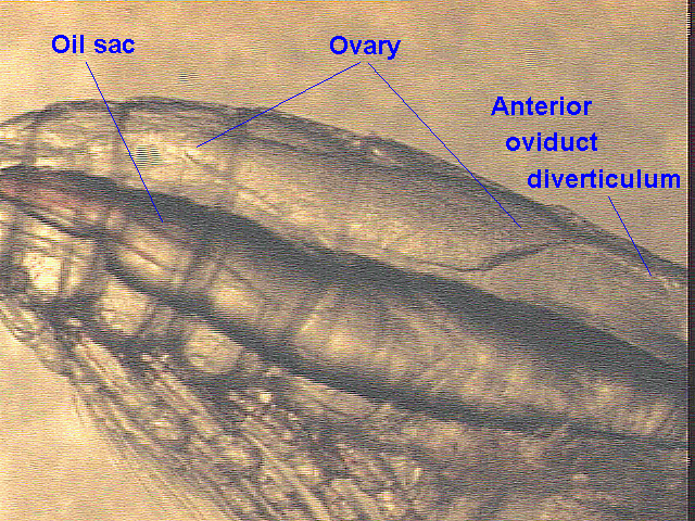
I represented the Oregon State University project on AL-98-01 and began a study of gonad development in Calanus finmarchicus. There is a gonad rudiment present in the copepodite stages of Calanid copepods, which in fifth copepodites (C5) of C. finmarchicus is about 0.2 mm long, located dorsally at the back end of the cephalosome. Using preserved specimens, we have been studying enlargement and sexual differentiation of these rudiments that occurs as C5s approach maturation. This work has been hampered by the opacity of the dorsal-longitudinal muscles in preserved specimens. So, on AL-98-01 I tried examining gonad rudiments in live specimens and taking videomicrographs (as computer image files) showing both the oil sac and gonad rudiment in the focal plane of a dissecting microscope. All specimens so recorded were individually preserved for a study of the correlations among oil sac fullness, gonad size and stage of tooth development, which will be studied ashore. The ease of gonad development observations for Calanus demonstrated on AL-98-01 will allow us to get a good idea of how many C5 are headed for diapause, how many headed for immediate maturation from the G1 and G2 generations of 1998. This January cruise proves the method and begins a seasonal series of gonad development data.
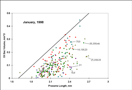
Well over half of Calanus individuals over the Bank and in the Gulf of Maine were adult, the smaller remainder C5. Gonads in a total of 255 C5 specimens were measured and recorded on AL-98-01. Gonad rudiments were visible in virtually all of them. Most of those were enlarged substantially from the 0.2 mm starting length in C5. Of those enlarged enough (typically >0.5 mm) to identify as ovary or testis, all but 2 or 3 were ovaries. This is reasonable, since males mature first, and the maturation of the stock from the rest phase was well along. An example of a developing ovary is shown in Figure 9. The forward extension of the anterior diverticulum of the oviduct shows that this will be an ovary in the adult. Oil sac volumes were estimated for all 255 specimens (an algorithm using various assumptions generates estimates of sac volume from its two-dimensional projection). Those are plotted as a function of body size in Figure10. This wild scatter is typical of all seasons on Georges Bank, although the density of occupation of various sectors on the plot varies. In this plot there are relatively few specimens above 2.5 mm prosome length, which again suggests that the maturation of the resting stock is well advanced; males (which mature first) are mostly larger as C5s than females (which the gonad study shows make up most of the remaining C5 stock).
General observations of the C. finmarchicus stock were made throughout the cruise. There were very few specimens in shallow parts of the Bank (<60 m water depth), and few all along the south flank. There were larger numbers over NE Peak, and particularly in deeper levels at Stations 39, 29, 34 and 38. Sieved volumes for standard 1-m2 MOCNESS depth intervals at these Gulf of Maine stations amounted to 40-60 ml, (compared to 2-4 liters in previous June sampling), and the stock was spread throughout the water column. The deeper hauls were predominantly C5, some males, a few females; surface hauls were predominantly females but with a few C5s and males present. This agrees with the usual life history pattern.
Centropages typicus in late life stages, predominantly adults, were abundant in deeper levels along the south flank of Georges Bank, particularly at Station 41. They were also mixed with the Calanus at the Guilf of Maine stations, and they were present over the Bank itself where they were mixed with an apparently actively growing (all stages present) stock of Centropages hamatus. It seemed early in the year to see so many of this last copepod over the Bank. The pteropod Limacina retroversa was particularly abundant around the periphery of the Bank, and it was present in virtually every sample we took on the cruise.
High Frequency Acoustics
(Peter Wiebe and Karen Fisher)
The primary focus of the bioacoustical effort on this cruise was to make high resolution volume backscattering measurements of plankton and nekton throughout the Georges Bank region. The acoustical data are intended to provide acoustical estimates of the spatial distribution of biomass of acoustical targets which span the size range of the target species (cod, haddock, Calanus, and Pseudocalanus) and their predators. Work on this cruise was designed to provide intensive continuous acoustic sampling along all the shipboard survey track lines in order to cover the entire Georges Bank region. The spatial acoustical map is also intended to provide an essential link between the physical oceanographic conditions on the Bank and the biological distributions of the species as determined from the net collections at the stations distributed throughout the Georges Bank region. Continuous acoustic data between stations can be used to identify continuity or discontinuity in water column structure which can in turn be used to qualify the interpretation of biological and physical data based on the point source sampling.
When the acoustics project was originally conceived, we believed that most of the energy coming back to a transducer would be echoes from plankton and fish. We have since learned from a number of cruises to Georges Bank that this world is not at all that simple. On top of the Bank, in the well-mixed area, we often find sand grains in large numbers being transported all the way to the sea surface. The grains, while small, are very hard and are good sound reflectors at the frequencies we are using. We now think that they often produce most of the backscattering that we are observing in waters shallower than 50 or 60 meters. In the deeper waters of the Bank, we find there are often internal waves that seem to be able to reflect sound independently of the animals living in the water column. The suspicion is that the sound speed or density contrasts that are the result of physical microstructure or turbulence are producing the echoed energy. We also have found in our research over the past few years that the animals themselves do not reflect sound in proportion to their numbers or biomass. The copepods and even the fish larvae that are the target species for our GLOBEC project are weak sound scatterers compared to the shelled pteropods. And on this cruise, the pteropods were incredibly abundant in many of the areas that we have surveyed.
Methods.
On this cruise, the R/V Albatross IV chem lab was the operations center for the high frequency acoustics work that was being done in an attempt to map the distribution and abundance of the animals living in the water column. The "acoustics system" consisted of the "Greene Bomber" (Figure 11), the chartreuse five-foot V-fin towed body, a Hydroacoustics Technology, Inc Digital Echo Sounder (HTI-DES), several computers for data acquisition, post processing, and logging of notes, plus some other gear. In the Greene Bomber, there were two down-looking transducers (120 and 420 kHz each with 3 degree beams), and an Environmental Sensing System (ESS). The ESS was mounted inside the V-fin with temperature, conductivity, and fluorescence sensors attached to a stainless steel framework outside of the fiberglass housing. A downwelling light sensor was attached to the tail. The fish was also carrying a transponder that would have proved useful in locating it if it had happened to break free of the towing cable.
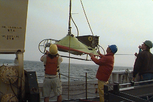
The tow-body was deployed from the starboard quarter of ALBATROSS and collected data both during and between stations. The general towing speed was 7.0 to 8 knots. The echosounder collected data at two pings per second per frequency. Conditions for conducting an echo sounder survey of the Bank were ideal during a good portion of this cruise and in spite of a couple of strong gales, we were able to collect acoustics data along the entire trackline of the cruise. The length of trackline acoustically mapped was ~800 nM (Figure 12; Table 1).

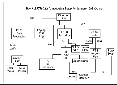
In the lab, the data came in on three separate wires, one for each transducer and one for the ESS (Figure 13 below). The HTI-DES has its own computer and five digital Signal Processor boards (DSPs). It received the data from the transducers, did a series of complex processing steps, and then transferred the results to the Pentium PC over a local area network (LAN) where the data were logged to disk and displayed. The "raw" unprocessed data were also written to a DAT tape (each tape holds two gigabytes of data and we used about 89 tapes during this cruise). Immense amounts of data were handled very quickly by this system. The environmental data came into a second PC and were processed, displayed, and logged to disk. Both systems required GPS navigation data and those data were being supplied by the ship's P-code GPS receiver and a Rockwell receiver that we put together. Periodically, the data were transferred to a third computer for post-processing. It was at this stage that we could visualize the acoustic records and begin to see the acoustic patterns which were characteristic of the Bank.
Some Results.
Georges Bank has two distinct regions hydrographically. On top of the Bank within the 60 meter isobath the water remains well-mixed all year. In this region, we have always found an acoustic structure that corresponds to the well-mixed structure i.e. the intensity of acoustic scattering at any given location remains more or less constant from the surface to the bottom. In the deeper portions of the Bank out to the 200 meter isobath, the water column is stratified a good portion of the year (late spring to winter), that is, there is a warm surface layer, a zone of rapid change in temperature (the thermocline), and then a deeper zone of colder water which extends to the bottom. In this situation, the acoustic scattering records usually show strong subsurface layers of intense scattering. In addition, it is along the thermocline that internal waves formed offshore propagate towards the well-mixed region. The acoustics data are very good at providing images of these waves. During the winter and early spring, the water column in this second region also becomes well-mixed because of the intense winter storms and cooling from the cold-Arctic air which often moves into the area. In earlier GLOBEC cruises where acoustics work was done in February (1995) and March (1996 &1997), the Bank was largely well-mixed and the acoustic data reflected this.
It was therefore expected that on this cruise, we would find a similar "Winter time" condition. But such was not the case. The deeper portions of the Bank were still stratified, although weakly so. And in keeping with previous observations of stratified situations, we observed very strong acoustic layering (Figure14). In fact, the scattering in some of the layers was much more intense than expected based on past experience and was probably related to another unexpected finding. The pteropod, Limacina retroversa, turned out to be much more abundant all around the outer margin of the Bank than was anticipated. Its abundances matched those we have only seen in May/June of 1992 on Albatross IV 9404. (However, Bigelow (1925) found it present in the northern and western parts of the Gulf of Maine during a December-January cruise in 1920-21 and based on data from others concluded that it was "as subject to sporadic fluctuations in abundance there during the cold season as during the warm".) As indicated above, this animal reflects sound back to the echosounder much more effectively than most other animals. Given the high numbers of individuals found in many of the net hauls in the same depths where the strong acoustic layers reside, we can begin to assume they were a major contributor to these layers.
Another feature that was not expected was a sharp dividing line between the well-mixed and the stratified areas at what is known as the tidal mixing front. In the other winter cruises, this front did not show up acoustically because most of the region was well-mixed. But in almost all of the crossings of area where this front occurred, the change was remarkably abrupt (Figure 15). In the section portrayed, the change takes place only over a few hundred meters.
One feature that was expected was internal waves at the margin of the Bank. In this we were not disappointed. A spectacular internal wave was observed as we left the Northeast Peak and headed to Georges Basin (Figure 16). The maximum height of the wave packet from peak to trough was about 80 to 90 meters. These waves are thought to form as the tide is flowing off the Bank. The off-bank flow sets up a standing wave (also known as a lee wave) that wants to move onto the Bank, but is held in place by the tidal flow. When the tide turns sufficiently, the wave is free to propagate onto the Bank at speeds of 1 to 1.5 knots. But it can only propagate onto the Bank as long as the water column is stratified and there is a contrast in the density of the water between the surface and the bottom. What happens to these waves when they meet the tidal mixing front at the start of the well-mixed region is not known. Under most conditions, this wave formation is thought to happen every tidal cycle.
Towards the end of the cruise as we were steaming out to Standard Station 34, a feature we had never seen before appeared. As we left the northern flank of the Bank and entered the deeper waters of Franklin Basin, alternating columns of heavy and light volume backscattering occurred in a semi-regular pattern (Figure 17). The columns originated near the surface and extended down to about 70 meters, immediately below which was a continuous layer of heavy backscattering about 15 or 20 thick. Below 100 m, the scattering was much less intense. The extent of the columnar structure coincided with the depth of the mixed layer which was 70 m deep. The pattern remained present throughout the period of work at the station and was very apparent when we were conducting net tows at speeds of 1.5 to 2.5 knots. Since the cruise took place during a period when winter cooling of the seawater was occurring, one possible explanation for this pattern in the acoustic record is that we were "seeing" convective cells where water was downwelling. Exactly how the variations in the backscattering are produced to create the columnar structure remains to be determined. We were forced to break off sampling after completing this station by a major winter storm which was bearing down on us. After the passage of the storm (during which time we were anchored near Provincetown harbor), we returned to Station 34 to find the mixed layer had deepened by about 20 meters and that the acoustic records reflected this. The columnar acoustic structure was present, but the backscattering was not as intense.
References
Bigelow, H.B. 1925. Plankton of the offshore waters of the Gulf of Maine. From BULLETIN OF THE BUREAU OF FISHERIES, Vol XL, 1924, Part II. Document No. 968.
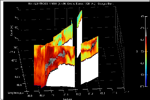
Figure 14. The echogram of 120 kHz data taken from Standard Station #12 to Standard Station #19 on the southern flank of Georges Bank. Note the very intense scattering over the shelf/Slope Water margin of the Bank and further on the bank at the lower right-hand portion of the plot. The 1-m2 MOCNESS plankton samples strongly suggest that the pteropod, Limacina retrovera , was largely responsible fot he backscattering.
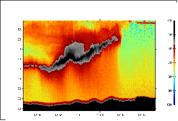
Figure 15. A blow-up of the image in Figure 14 that shows the abrupt change from the stratified portion of the Bank to the well-mixed portion. The image also provides finer detail on the layer that the pteropods may be principally responsible for.
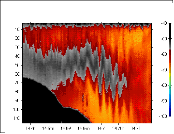
Figure 16. An internal wave packet observed along the transect
line between the northeast peak and Georges Basin (Standard Stations
28 and 29) on 14 January 1998. It is not clear what is
causing the intense backscattering within the wave form.
X-axis: Year-Day Time; Y-axis: Depth (m).
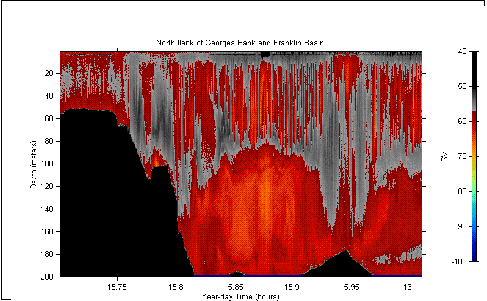
Figure 17. An acoustic section running from the northern flank of Georges Bank near Station 33 out to Station 34 in Franklin Basin, then returning towards the Bank during a 1 m2 MOCNESS tow 9 (where the bottom reappears), and finally back out into the basin again during a 10 m2 MOCNESS tow (the turning point is where the bottom peaks and then subsides). This figure illustrates a columnar acoustic pattern that may be related to convective mixing cells that we suspect were present in the Franklin Basin during the period of the sampling.
| Table 1. Acoustic Data Summary and concomitant observations. | |||||||||
| Data Acquisition Log for ALBATROSS IV - GLOBEC Cruise 9801 | |||||||||
| HTI-244 Echosounder running 120 and 420 kHz Tranducers, config file WHOI-120-420.cfg | |||||||||
| Sta/Leg | Date | DAT
Tape # |
Start
DAT |
Stop
DAT |
Acoustic
File |
Start
ESS |
End
ESS |
ESS File
Name |
Comments |
| 1-2 | 98008 | 1 | 09:57 | 11:03 | W0080807 | 09:54 | gb00001 | gmt mess up for some reason; testing ac file. | |
| 1-2 | 98008 | 1 | W0080848 | 13:48 GMT now ok | |||||
| 98008 | 1 | W0080848 | 09:57 start DAT ; fish flight adjustments | ||||||
| 98008 | 1 | W0080848 | 09:54 | gb00001a | 09:54 problems with gps/no date | ||||
| 98008 | 1 | W0080848 | 09:58 slowing for BONGO | ||||||
| 98008 | 1 | 10:59 gps to ESS from ship now | |||||||
| 98008 | 2 | 11:14 | 13:21 | TAPE #2 in | |||||
| 98008 | 2 | 11:59 | 12:03 | W0081200 | DEP died. Illegal operation. | ||||
| 98008 | 2 | 12:03 | W0081203 | 15:32 | gb00001b | Restart to turn on Xmitter | |||
| 98008 | 3 | 13:21 | 15:26 | W0081203 | TAPE #3 in | ||||
| 2-41 | 98008 | 3 | W0081203 | 14:30 Calm day; 120 blue 25-55m/420 10-20m | |||||
| 2-41 | 98008 | 4 | 15:28 | 17:34 | W0081203 | TAPE #4 in | |||
| 41 | 98008 | 4 | W0081531 | 15:34 | 22:10 | gb00003 | STATION 41 file changes | ||
| 1-3 | 98008 | 5 | 17:35 | 19:58 | W0081531 | TAPE #5 TAPE GAP *** | |||
| 41-3 | 98008 | 6 | 19:59 | 22:07 | W0081531 | TAPE #6 | |||
| 3 | 98008 | 7 | 22:08 | 00:15 | W0082209 | 22:12 | 05:59 | gb00004 | TAPE #7 |
| 3 | 98009 | 8 | 00:16 | 02:28 | W0082209 | TAPE #8 TAPE GAP *** | |||
| 3-4 | 98009 | 9 | 02:28 | 04:37 | W0082209 | TAPE #9 | |||
| 3-4 | 98009 | 10 | 04:37 | 07:09 | W0082209 | ||||
| 4 | 98009 | 10 | W0080558 | 06:02 | gb00005 | STATION 4 file changes/weather ok | |||
| 4 | 98009 | 10 | 08:08 41 01.5693N 68 16.56W Fish back in | ||||||
| 4 | 98009 | 11 | 08:39 | 10:49 | W0090837 | restarted acoustics after servicing fish | |||
| 4 | 98009 | 11 | 08:40 enabled xmit | ||||||
| 4-5 | 98009 | 11 | 10:13 Unable to query option | ||||||
| 4-5 | 98009 | 11 | 10:37 module restart ok | ||||||
| 5 | 98009 | 12 | 10:50 | 11:40 | W0090837 | some ac missing on tape | |||
| 6 | 98009 | 12 | 15:08 | 16:32 | W0091507 | 15:08 | 20:44 | gb00006 | tow 3 in water; spliced out short in ESS cable |
| 6 | 98009 | 12 | W0091517 | now try with xmit ON | |||||
| 6-7 | 98009 | 13 | 16:34 | 18:40 | TAPE # 13 | ||||
| 6-7 | 98009 | 14 | 18:41 | 20:49 | |||||
| 7 | 98009 | 14 | W0092041 | 20:45 | 05:30 | gb00007 | STATION 7 file change/gb00006init?) | ||
| 7 | 98009 | 15 | 20:50 | 22:57 | |||||
| 7 | 98009 | 16 | 22:58 | 01:08 | |||||
| 7-8 | 98010 | 17 | 01:08 | 03:14 | |||||
| 7-8 | 98010 | 18 | 03:15 | 05:21 | |||||
| 8 | 98010 | 19 | 05:22 | 07:44 | W0100527 | 05:30 | 08:49 | gb00008 | STATION 8 file changes/missed some on station |
| 8-9 | 98010 | 20 | 07:44 | 10:26 | |||||
| 9 | 98010 | 20 | W0100849 | 08:51 | 14:00 | gb00009 | STATION 9 file changes\ got it on time! | ||
| 9 | 98010 | 21 | 10:27 | 12:34 | |||||
| 9-10 | 98010 | 22 | 12:34 | 14:41 | |||||
| 10 | 98010 | 22 | W0101411 | 14:12 | 17:00 | gb00010 | STATION 10 file changes CTD ONLY | ||
| 10-11 | 98010 | 23 | 14:42 | 16:48 | W0101700 | 17:00 | 21:07 | gb00011 | STATION 11/ FTPed FILES--GAP on station |
| 11 | 98010 | 24 | 16:50 | 19:16 | |||||
| 12 | 98010 | 25 | 19:16 | 21:31 | W0102107 | 21:09 | 01:28 | gb00012 | STATION 12 |
| 12 | 98010 | 26 | 21:32 | 23:42 | |||||
| 12-13 | 98010 | 27 | 23:43 | 01:49 | W0110004 | tape change a bit late; DEP QUIT, illegal op. | |||
| 13 | 98011 | 27 | W0110126 | 01:28 | 05:26 | gb00013 | STATION 13 | ||
| 13 | 98011 | 28 | 01:59 | 03:54 | W0110343 | error message; lots of trouble restarting | |||
| 13-14 | 98011 | 28 | 354 | both ducers on disable and beeping | |||||
| 13-14 | 98011 | 28 | 403 | turned off power | |||||
| 13-14 | 98011 | 29 | 04:09 | 06:20 | W0110408 | RESTART (beeping went away) | |||
| 14 | 98011 | 29 | W0110524 | 05:27 | 09:06 | gb00014 | STATION 14 T & S converging, F down | ||
| 14 | 98011 | 30 | 06:21 | 08:27 | got tape change right on schedule | ||||
| 14-15 | 98011 | 31 | 08:28 | 10:50 | system running ok | ||||
| 15 | 98011 | 31 | W0110906 | 09:09 | 12:16 | gb00015 | started files just as bongo net deployed; STATION 15 | ||
| 15-16 | 98011 | 32 | 10:52 | 13:30 | missed getting this one changed a bit | ||||
| 16 | 98011 | 32 | W0111216 | 12:18 | 21:21 | gb00016 | started new files as STATION 16 started | ||
| 16 | 98011 | 33 | 13:31 | 15:38 | missed this one by 30 minutes but on station | ||||
| 16 | 98011 | 34 | 15:39 | 18:06 | stopped acoustics 1609 | ||||
| 16 | 98011 | 34 | W0111630 | stopped during sta. 16 to FTP files to p133 | |||||
| 16-17 | 98011 | 35 | 18:07 | 20:24 | a little slow getting this one in | ||||
| 16-17 | 98011 | 36 | 20:24 | 22:32 | INTERNAL WAVE so missed tape change... | ||||
| 17 | 98011 | 36 | W0112120 | 21:23 | 01:37 | gb00017 | STATION 17 file changes | ||
| 17 | 98011 | 37 | 22:33 | 00:40 | Station 17 still | ||||
| 17-18 | 98012 | 38 | 00:41 | 02:47 | Change of tape in the midst of the Big Bang Patch | ||||
| 18 | 98012 | 38 | W0120136 | 01:38 | 07:32 | gb00018 | ... that ended just before STATION 18 | ||
| 18 | 98012 | 39 | 02:48 | 04:54 | |||||
| 18-19 | 98012 | 40 | 04:55 | 07:01 | W0120641 | 06:43 | 07:36 | gb00019 | start right after Bongo Tow STATION 19 |
| 19 | 98012 | 41 | 07:08 | 09:08 | 07:42 | 15:44 | gb00019b | ended acqui to transfer ess files; ftp failed | |
| 19 | 98012 | 42 | 09:09 | 11:53 | good thing alarm went off | ||||
| 20 | 98012 | 42 | 1030 STATION 20 NO FILE CHANGES | ||||||
| 20 | 98012 | 43 | 11:55 | 14:06 | missed by a long shot | ||||
| 20-21 | 98012 | 44 | 14:07 | 16:13 | 1515 stopped to retrieve fishing floats/net | ||||
| 21 | 98012 | 44 | W0211543 | 15:46 | 20:21 | gb00021 | STATION 21 | ||
| 21 | 98012 | 45 | 16:14 | 18:21 | |||||
| 21-22 | 98012 | 46 | 18:23 | 20:28 | |||||
| 22 | 98012 | 47 | 20:29 | 22:31 | STATION 22 | ||||
| 22 | 98012 | 47 | W0122111 | 21:20 | 22:31 | gb00022 | restarted files after ESS ftp/ stopped ac 20:59 | ||
| 22-23 | 98012 | 48 | 22:32 | 00:44 | W0122337 | 23:36 | 03:41 | gb00023 | STATION 23 |
| 23 | 98013 | 49 | 00:45 | 02:51 | ESS bumps and jumps, lots of fronts | ||||
| 23-24 | 98013 | 50 | 02:52 | 04:59 | Bongo Tow | ||||
| 24 | 98013 | 50 | W0130341 | 03:41 | 09:57 | gb00024 | STATION 24 | ||
| 24 | 98013 | 51 | 05:00 | 07:06 | |||||
| 24-25 | 98013 | 52 | 07:07 | 09:12 | Thank you Alarm! got it on time | ||||
| 24-25 | 98013 | 53 | 09:14 | 11:19 | end0957 | Ah, the alram did it again. Very essential | |||
| 24-25 | 98013 | 53 | Bring fish on board for check | ||||||
| 25 | 98013 | 53 | W0131013 | 10:12 | 15:47 | gb00025 | DAT tape left running while fish out of water | ||
| 25 | 98013 | 54 | 11:20 | 13:25 | changed on time | ||||
| 25 | 98013 | 55 | 13:27 | 15:34 | changed on time | ||||
| 25 | 98013 | 56 | 15:34 | 17:41 | |||||
| 39 | 98013 | 56 | W0131546 | 15:48 | 22:09 | gb00026 | STATION 39 ESS name is 26 by mistake *** ESS | ||
| 39 | 98013 | 57 | 17:42 | 19:48 | still 39, coming onto Bank | ||||
| 39-26 | 98013 | 58 | 19:49 | 21:55 | ok for timing | ||||
| 26 | 98013 | 59 | 21:57 | 00:03 | ok timing on STATION 26 | ||||
| 26 | 98013 | 59 | W0132208 | 22:09 | 01:56 | gb00026b | STATION 26 | ||
| 26-27 | 98014 | 60 | 00:04 | 02:11 | Bongo station | ||||
| 27 | 98014 | 61 | 02:12 | 04:17 | W0140155 | 01:57 | 11:00 | gb00027 | STATION 27 |
| 27-28 | 98014 | 62 | 04:18 | 06:25 | Bit Rough | ||||
| 27-28 | 98014 | 63 | 06:27 | 10:56 | Started at sound of alarm | ||||
| ? | 98014 | 64 | 10:58 | 13:05 | missed this one- alarm not set right | ||||
| ? | 98014 | W0141100 | 11:02 | 15:25 | gb00027b | 11:00 Changed files, since big | |||
| 28 | 98014 | 65 | 13:06 | 15:13 | got it | ||||
| 28 | 98014 | 66 | 15:14 | 17:22 | W0141521 | 15:26 | 18:31 | gb00028 | Return to 28- INTERNAL WAVE |
| 28 | 98014 | 67 | 17:23 | 19:28 | 1806 ended DEP and will FTP files over | ||||
| 29 | 98014 | 67 | W0141830 | 18:33 | 03:04 | gb00029 | Restarted DEP writing to D:/HTI_DEP/DATA | ||
| 29 | 98014 | 68 | 19:30 | 21:36 | STATION 29 | ||||
| 29 | 98014 | 69 | 21:38 | 23:44 | started on time | ||||
| 29-30 | 98014 | 70 | 23:45 | 01:52 | wow. Big Donut and Donut Hole (420 and 120 resp) | ||||
| 29-30 | 98015 | 71 | 01:52 | 03:58 | W0150301 | 03:05 | 08:15 | gb00030 | STATION 30 |
| 30 | 98015 | 72 | 04:00 | 06:06 | on way to station 31 | ||||
| 30-31 | 98015 | 73 | 06:08 | 08:13 | ended at start of station 31 | ||||
| 31 | 98015 | 74 | 08:15 | 11:47 | W0150815 | 08:17 | 12:21 | gb00031 | Started files w/Bongo tow, no tape change |
| 31-32 | 98015 | 75 | 11:48 | 12:47 | no alarm, or out when it went off | ||||
| 32 | 98015 | 75 | W0151221 | 12:22 | 15:30 | gb00032 | STATION 32 | ||
| 32 | 98015 | 75 | 12:47 Paused DATand ESS to pull fish out | ||||||
| 32 | 98015 | 75 | 13:36 | 15:45 | W0151337 | 1336 END PAUSE (108 on DAT tape) | |||
| 32-33 | 98015 | 76 | 15:46 | 17:02 | W0151528 | 15:30 | 18:48 | gb00033 | Bongo Station |
| 33 | 98015 | 77 | 17:03 | 19:42 | STATION 33 (really) 1841 reverse DONUT | ||||
| 33-34 | 98015 | 78 | 19:42 | 21:20 | 19:16 | 21:46 | gb00033b | after DATA transferred, ESS started | |
| 34 | 98015 | 79 | 21:40 | 23:49 | W0152149 | 21:48 | 00:21 | gb00034 | STATION 34 CONVECTION PICTURE so missed tape |
| 34 | 98015 | 80 | 23:50 | convection cells not as regular | |||||
| 34 | 98015 | 0021 END DATA ACQUISITION and RUN for cover | |||||||
| RE-34 | 98018 | 81 | 02:04 | 04:10 | W0180202 | 02:02 | 04:57 | gb00034b | C: New Tape, back to station 34 CIRC cells Still Here |
| 34-35 | 98018 | 82 | 04:11 | 06:18 | F climbing T and S down, SNAILYELL.bmp | ||||
| 35 | 98018 | 82 | W0180456 | 04:58 | 08:27 | gb00035 | started files as MOC went in on C drive | ||
| 35-36 | 98018 | 83 | 06:19 | 08:25 | at the bongo station for tape change | ||||
| 36 | 98018 | 84 | 08:25 | 10:32 | W0180826 | 08:29 | 12:40 | gb00036 | a little slow changing computer files at station, D drive |
| 36-37 | 98018 | 85 | 10:33 | 12:40 | changed just before intermediate bongo station | ||||
| 37 | 98018 | 86 | 12:40 | 14:46 | W0181240 | 12:40 | 15:48 | gb00027 | changed tape late into station and also changed files late |
| 37-38 | 98018 | 87 | 14:47 | 16:54 | nifty layer | ||||
| 38 | 98018 | 87 | W0181546 | 15:50 | 19:27 | gb00038 | STATION 38 | ||
| 38 | 98018 | 88 | 16:54 | 19:02 | |||||
| 38 | 98018 | 89 | 19:02 | 19:27 | end1927 | END ACQUISITION | |||
Microzooplankton Analysis. The Importance of Microzooplankton in the Diet of Newly Hatched Cod Larvae: Broad-scale Studies of Prey Abundance.
(Shannon Houle and Ethan Howard for S. Gallager)
One objective of this study is to characterize seasonal changes in the potential prey field for newly hatched cod larvae with respect to prey motility patterns and the prey size spectrum.
Prey Size, Abundance and Motility Experiments:
Purpose:
To observe, record and analyze motility patterns and size spectrum of available prey from three locations in the water column- near bottom, pycnocline, and upper well-mixed area at all broad- scale stations from January through June.
General Procedure:
Water samples are collected from the near bottom, and pycnocline areas of the water column using Go-Flo bottles on the Neil Brown Mark V CTD. Surface samples are collected with a plastic bucket. Go-Flo bottle samples are collected by gently siphoning from the top of the bottle instead of the normal port so that microplankton are not disrupted. Tissue culture flasks (200-ml) are filled after being dipped in soapy water and air dried to prevent fogging. To further prevent fogging as well as maintaining a constant low temperature, flasks are transferred to an incubator at 5 C immediately after filling.
Each flask, in turn, is placed in a holder across from a B/W high-res Pulnix camera fitted with a 50 mm macrolens and directly in front of a fiber optic ring illuminator fitted with a far-red filter. This apparatus is suspended within the incubator by bungee cord to reduce vibration produced by the ship. Recordings are made using a Panasonic AG1980 video recorder with SVHS formatted cassettes, a Panasonic TR-124MA Video Monitor, and a timing device for a period of 15 minutes for each sample. The flask is then replaced with the next sample and recordings continue. The field of view is set to ~10 mm.
Each priority #1 station was analyzed; samples were recorded and preserved in 10% Lugols solution. At stations #16 and #18, samples from the three depths (surface, bottom, and pycnocline) were recorded, but only the surface samples were preserved in Lugols solution. Water samples from priority #2, 3 and 4 stations were recorded but not preserved.
Post cruise processing:
Motility patterns will be analyzed with the Motion Analysis EV system. The final output will be particle size distribution and a motility spectra associated with each particle. This will be compared with species composition in the microzooplankton fraction preserved in Lugols solution.
Collections for Genetic Studies.
(for A. Bucklin)
It is essential for understanding variations in the winter production of zooplankton on the Bank as well as a knowledge of the origin or sources of the target species Calanus finmarchicus, and Pseudocalanus sp. as well as the Spring zooplankton bloom. Individuals are believed to come onto the Bank from the Gulf of Maine, Gulf of St. Lawrence, Scotian Shelf, and possibility the Slope Water. However, it is impossible to define through the morphology of the individuals where zooplankton currently found on the Bank originated. Consequently, population genetics studies of Calanus, Pseudocalanus, and several other species (e.g. the euphausiid, Meganyctiphanes norvegica) are being conducted at the University of New Hampshire by A. Bucklin. This in an effort to identify viable genes to characterize dispersal patterns and to provide a genetic basis upon which to gauge Bank production as a function of recruitment source populations. An attempt to distinguish between the morphologically similar Pseudocalanus species found year round on the Bank (e.g. molutoni and newmani) is also being developed, as well as genetic based analysis of their Bank circulation patterns and dispersal pathways. The work mentioned above is tied directly to other efforts to identify water sources and losses for the Bank, as well as circulation and exchange processes across the Bank boundaries. On this cruise, samples were collected at every station for genetic studies with net #5 on the 1-m2 MOCNESS. At selected stations, 90 ml subsamples from the bottom and surface 1-m2 MOCNESS with 150-�m mesh nets were taken. All samples were preserved in 95% ethyl alcohol which was changed during the first 24 hr period after collection.
Drifter Deployments.
(for R. Beardsley and R. Limeburner)
As part of the physical oceanographic studies of the current structure and circulation on Georges Bank being conducted by R. Beardsley and R. Limeburner, GLOBEC Drifter Buoys are deployed at strategic locations periodically throughout the year to track the Lagrangian flow from the point of deployment. This drifter is constructed with a holey sock drogue (a Dacron cylinder 90 cm diameter by 3 m tall with 5 circular hoop stays) at the bottom connected by either a 10 m or a 40 m cable to a small float (18 cm diameter) which in turn is connected by about 2.6 m of cable to a larger spherical surface float (about 32 cm diameter). The surface float contains a sea surface temperature sensor, a GPS receiver, and an ARGOS satellite transmitter. Temperature, time, and position data are transmitted periodically to shore through the ARGOS telemetry system. On this cruise, one 10m drifter was deployed.
Shipboard ADCP (Acoustic Doppler Current Profiler) Measurements.
(for J. Candela and C. Flagg)
The flow field over Georges Bank is driven by a complex set of forces. A primary factor is the strong semidiurnal tides which dominate the high frequency variability (<1cpd) of the currents. Tidal rectification gives rise to a persistent subinertial clockwise circulation over the Bank. This circulation process can be substantially modified by the frequent storms common to the area, changes in the stratification of the Bank. and interactions with currents generated by offshore circulation features (i.e. Warm-Core Rings).
The Acoustic Doppler Current Profiler is one of the instruments being used to study the circulation process on the Bank by J. Candela and C. Flagg. Water current measurements were obtained using a 150 kHz RDI ADCP continuously during the entire cruise. The transducers were mounted on the hull of the ship (5 m below the surface with a heading offset (OH) of -1.5). The instrument was programmed to measure the current profile under the ship with a vertical resolution of 2 m, from 10 m depth to about 10 m from the bottom or up to a depth of about 120 m, which ever was shallower at a given location. The current profiles were generated by 60 s data averages. Transformation to geographical North and East current components was preformed using real time gyro information fed into the ADCP from the ship's navigation instrumentation. Also fed to the instrument was real time GPS positioning which was stored directly in the minute average profile data files. The ADCP measures currents with respect to the ship. To obtain the water current with respect to the ocean bottom, the ship's motion needs to be removed from the current observations. The ship's motion will be removed using the bottom track (BT) velocity measured by the ADCP. Depending upon sea conditions, the ADCP can preform this operation in water depths shallower than 200 to 230 m. When the BT is lost, accurate navigation will be used to remove the ship's velocity from the current.
The ADCP data collected on this cruise will be post-processed at Woods Hole Oceanographic Institution by Candela and Flagg.
Personnel List
Scientific
Name Title Organization
1. John Sibunka Chief Scientist NMFS/NEFSC, Sandy Hook, NJ
2. David Mountain Phys. Oceanographer NMFS/NEFSC, Woods Hole, MA
3. Cristina Bascunan Phys. Sci. Tech. NMFS/NEFSC, Woods Hole, MA
4. Peter Wiebe Senior Scientist WHOI, Woods Hole, MA
5. Charles Miller Professor OSU, Corvallis, OR
6. Maria Casas Research Associate URI/GSO, Narragansett, RI
7. Peter Garrahan Research Associate URI/GSO, Narragansett, RI
8. Riley Young Biol. Sci. Technician URI/GSO, Narragansett, RI
9. David Nelson Science Technician URI/GSO, Narragansett, RI
10. Joseph Kane Fish. Biologist NMFS/NEFSC, Narragansett, RI
11. Stephen Brownell Biol. Sci. Technician NMFS/NEFSC, Narragansett, RI
12. Karen Fisher Grad. Student Cornell Univ. Ithaca, NY
13. Shannon Houle Student Massachusetts Maritime Academy
14. Ethan Howard Student Massachusetts Maritime Academy
ALBATROSS IV Officers and Crew
1. Derek Sutton Commanding Officer
2. Jason Maddox Executive Officer
3. Stephen Wagner Operations Officer
4. David Santoro Navigation Officer
5. Kevin Cruse Chief Engineer
6. John Hurder First Assistant Engineer
7. Chuck Hersey Second Assistant Engineer
8. Grady Abney Third Assistant Engineer
9. Orlando Thompson Utility Man
10. Jess Jacobson General Vessel Assistant
11. Tony Alvernaz Chief Boatswain
12. William Amaro Lead Fisherman
13. Tony Viera Skilled Fisherman
14. Jorge Barbosa Skilled Fisherman
15. Anthime Brunette Fisherman
16. Douglas Roberts Fisherman
17. Richard Whitehead Chief Steward
18. Jerome Nelson Chief Cook
19. Henry Jenkins Electronics Technician
20. Richard Holly Electronics Technician
Appendix 1. Data inventory - List of Underway and station Activities.
Appendix 2. CTD Plots and Compressed Listings Of the Data.