R/V ALBATROSS IV AL9906 Cruise Report
ACKNOWLEDGMENTS
We thank the captain, officers, and crew of the R/V ALBATROSS IV
for a very productive and enjoyable cruise; their skill,
professionalism, and friendly cooperation enabled us to complete the
last of the GLOBEC Georges Bank broad-scale cruises with all of the
scientific missions successfully accomplished.
This report was prepared by Peter Wiebe, Maureen Taylor, John
Sibunka, Jamie Peirson, Steven Brownell, Charlie Miller, Abigale
Dietz, and Karen Fisher with assistance from others in the
Scientific Party. This cruise was sponsored by the National Science
Foundation and the National Oceanographic and Atmospheric
Administration.
TABLE OF CONTENTS
INTRODUCTION
Purpose of the cruise.
NARRATIVE
INDIVIDUAL REPORTS
Hydrography
Data:
Results:
Zooplankton and Ichthyoplankton studies based on Bongo and MOCNESS tows.
Objectives:
Methods:
Preliminary Summary of Ichthyoplankton Findings.
Cod (Gadus morhua) and Haddock (Melanogrammus aeglefinnus): 23
Miscellaneous Fish Larvae:
Preliminary Summary of the 10-m2 MOCNESS samples.
Zooplankton Predator Sampling.
Zooplankton Observations on AL9906.
Egg production rates and gonad development of dominant copepod species
Nutrients and Phytoplankton Studies.
Overview:
Methods:
Preliminary Results:
References:
Stable Isotope Sampling
High Frequency Acoustics
Methods.
Gear Problems
Some Results.
Greene Bomber Environmental Data AL9906
Drifter Deployments.
Shipboard ADCP (Acoustic Doppler Current Profiler) measurements.
CRUISE PARTICIPANTS
Scientific Personnel
Officers and Crew
APPENDIX I.
Event Log.
APPENDIX II. Chlorophyll, nutrient, and other measurements.
APPENDIX III.
Acoustic Tape Log.
APPENDIX IV. CTD profiles.
INTRODUCTION
Purpose of the cruise.
The U.S. GLOBEC Georges Bank Program is now into its fifth and last full field season and this cruise was the last in a series of six broad-scale cruises taken place at monthly intervals between January and June. In fact, this was the last of 31 broad-scale cruises which started in June 1994. Our specific objectives were:
1) To conduct a broad-scale survey of Georges Bank to determine the abundance and distribution of U.S. GLOBEC Georges Bank Program target species which are the eggs, larval, and juvenile cod and haddock and the copepods Calanus finmarchicus and Pseudocalanus spp.
2) To conduct a hydrographic survey of the Bank.
3) To collect chlorophyll data to characterize the potential for primary production and to calibrate the fluorometer on the CTD.
4) To map the bank-wide velocity field using an Acoustic Doppler Current Profiler (ADCP).
5) To collect individuals of C. finmarchicus, Pseudocalanus spp., and the euphausiid, Meganyticphanes norvegica, for population genetic studies.
6) To conduct life history studies of C.
finmarchicus.
7) To conduct acoustic mapping of the plankton along the tracklines between stations using a high frequency echo sounder deployed in a towed body.
8) To deploy drifting buoys to make Lagrangian measurements of the currents.
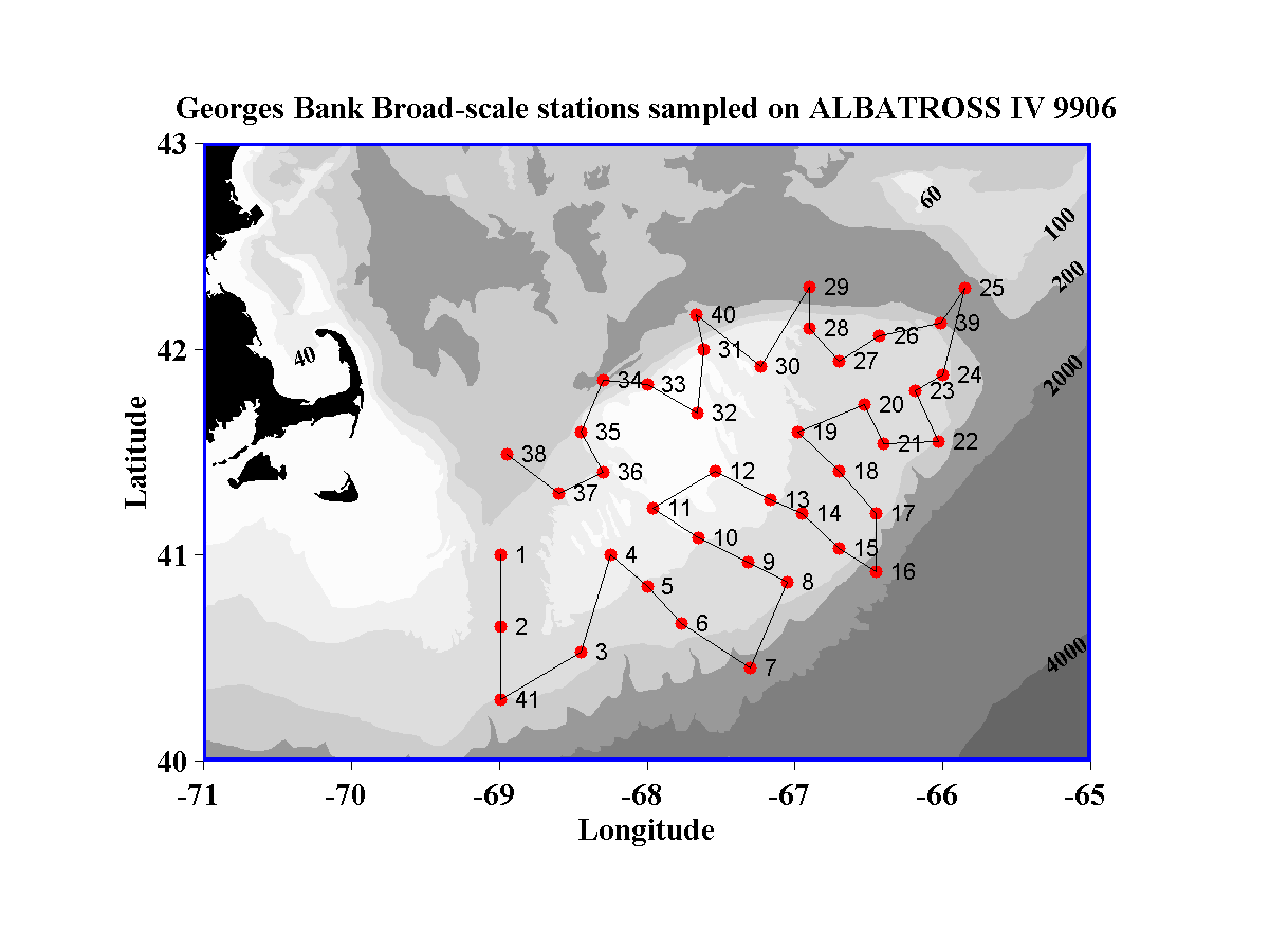
The cruise track was determined by the position of the 41 AStandard@ stations that form the basis for all of the broad-scale cruises. The entire Bank, including parts that are in Canadian waters, was surveyed (Figure 1).
The work was a combination of station and underway activities. The along-track work consisted of high frequency acoustic measurements of volume backscatter of plankton and nekton throughout the water column and surface measurements of temperature, salinity, and fluorescence from the towed body. The ship=s 300 kHz ADCP unit was used to make continuous measurements of the water current profile under the ship, in order to construct the current field over the whole Bank. Meteorological data, navigation data, and sea surface temperature, salinity, and fluorescence data were measured aboard the ALBATROSS IV. Some of these data are presented in the Acoustic Report Section below.
A priority was assigned to each of the 41 standard stations that determined the equipment that was deployed during the station=s activities. At high priority Afull@ stations, a Bongo net equipped with a SeaBird CTD was towed obliquely to near the bottom. A CTD-fluorometer/transmissometer profile to the bottom was made and rosette bottles collected water samples for salinity and chlorophyll calibrations, chlorophyll concentrations, phytoplankton species counts, nutrients, and 18O/16O water analysis. A large volume zooplankton pumping system was used to profile the water column. A 1-m2 MOCNESS was towed obliquely to make vertically stratified collections for zooplankton (150 mm mesh) and then to make collections of fish larvae (335 mm mesh). A 10-m2 MOCNESS was towed obliquely to make vertically stratified collections of juvenile cod and haddock, and the larger predators of the target species. A Jelnet was also deployed in an attempt to collect fragile gelatinous animals that are often destroyed in the other net collecting devices. At lower priority stations, a Bongo tow, CTD profile, and 1-m2 MOCNESS tow were made, and at many of these stations a 10-m2 MOCNESS tow was made. On occasion, a Reeve net was towed to collect living animals for experiments during and after the cruise. At a point halfway between stations surface water samples were collected for chlorophyl and nutrient measurements. A summary of the sampling events that took place during the cruise is in Appendix I.
NARRATIVE
We left Woods Hole on a sunny Monday afternoon (14 June 1999) at 1530 and steamed down the Nantucket Sound to get to our first station. Sea conditions were fine as we set sail.
Shortly after leaving port, we had a safety meeting which involved all in the science party and was led by Dave Zezula, the Field Operations Officer, followed by a meeting of the science party to discuss the work plans for the cruise and to acquaint those individuals taking part on a broad-scale cruise for the first time with some of the procedures to be followed when they were on watch. There were two watches each of 12 hours duration. Watch one was from 0600 to 1400 and 1800 to 2200 and was led by John Sibunka. Watch two was from 2200 to 0600 and from 1400 to 1800, and was led by Jamie Pierson.
15 June
The cruise got off to a good start. The steam out to the first station was uneventful. The winds were in the 15 to 20 kt. range and the seas were bumpy, but not rough. The work started in the early hours of 15 June at Standard Station 1 and the gear was working properly right from the beginning. For most of the day, the skies were overcast and we had a bit of drizzle from time to time, but the seas were ideal for the survey work.
At Station 3, there was difficulty with the conducting cable on both the boom and the starboard winches. The latter was the first to go at station #3 and the CTD at that station (and stations 4-6) had to be done off of the boom winch. It appeared the problem was in the starboard winches cable termination, and after some checks, it was cut off so that it could be renewed. But it was later determined that the slip rings on that winch were badly corroded and needed replacement. While using the cable on the boom winch to do the CTD cast, dropouts and spikes occurred giving an indication that all was not well with that winch and wire as well. During Station #4, the boom cable became inoperable because of shorting in the wire. In the wee hours, the electronics technician, Henry Jenkins, came to the rescue. He found and fixed one problem associated with the cable termination wiring. The night watch was able to complete Station 4.
There were pretty spectacular catches of pteropods at Stations 2 and 41. The 420 kHz echograms were particularly noteworthy with exceedingly strong backscattering coming in the pcynocline where the pteropods seem to be aggregated.
We completed work at the first four Standard Stations (1, 2, 41, and 3) and were nearly finished the fifth (4) by the end of the day.
16 June
On the second full day on the Bank, the skies continued to be overcast, but now and then the sun appeared and the seas remained ideal. The gear continues to work well, but problems persisted with the boom winch/wire, and during Station #5, it again became inoperable while attempting to do the 1-m2 MOCNESS tow. Henry Jenkins again went to work and this time, the termination had to be re-poured. Given the time required to fix the cable, we elected to omit the 1-m2 MOCNESS tow and to steam to Station 6. By the time we reached station 6, the boom cable tested out OK and was ready to go. But the CTD cast again had a number of spikes and dropouts and it was suspected that the cable, which was very rusty and not in good shape, might not have been able to support the voltages that the CTD runs through the cable. The evening saw another long session working on the starboard winch and wire. Maureen Taylor, the CTD guru, had managed to complete a CTD at Station 7 after the earlier repairs, but it had spikes and dropouts. She was able to remove these when post processing the CTD data, but it was a pain. And it meant that something was wrong with the cabling. So Maureen asked Henry Jenkins to check the system out again. In the earlier repairs, the slip rings were replaced with another set that were onboard. Thinking that this was the cause of the current problems, Henry replaced the slip rings with the original set. In testing, however, Maureen found the CTD did not work at all. Henry tested the wire again with and without the slip rings in place and it looked like the problem was in the cable termination. But when the electrical conductors coming out of the termination were cleaned and the bare wires tested, the cable appeared OK. Then when the slip rings were hooked up, the problem came back. The replacement slip rings were again installed and this time the cable with slip rings in place tested OK. Neither the wire or the slip rings is very good, however, and the two CTD casts done by the night shift at Stations 8 and 9 had dropouts and spikes, but no loss of signal. We had to live with this situation and fortunately it did not get worse during the rest of the cruise.
Work at stations ( 4, 5, 6, and 7) were completed and work at Station 8 was started.
17 June
The skies continued to be overcast with rain during the night that was heavy at times. The wind picked up for a while to about 25 kts and seas got choppy. Skies remained heavily overcast and there was an off/on drizzle. Late in the day the wind let up a bit and the seas, which were never bad enough to force us to curtail operations, diminished.
The gear also continued to function well and all that was needed was maintenance of the 10-m2 MOCNESS nets which required sewing up the top corners of Net zero to repair a reinforcement fabric that had broken. It took about an hour and a half to complete the job in the wind and rain. On the other side of the ledger, the ship experienced two minor power failures when start up of one of the winches caused a generator to overload. Generally, the scientific equipment is protected from such failures by a centralized Uninterruptable Power Supply system.
We experienced some rather different hydrographic conditions on the portion of the southern flank surveyed to this point in the survey. The water was much warmer than normal, even on the crest of the Bank and there was a major incursion of very warm and saline water (21+C and 35.9 PSU) at least up to the 100 m mark on some of the tracklines.
On the third day, we completed work at stations 8 through 12 and started work at Station 13.
18 June 1999
This day began about like the previous two, with skies overcast and rain off and on sometimes heavy and sometimes just a drizzle. The wind was pretty steady at 15 to 25 kts during the night and in the morning picked up for a while with gusts to about 30 kts. The seas were rougher than previously, but not enough to stop the work from proceeding. The gear ran well.
There were no major problems with the science gear to speak of, although the problem with the CTD dropouts and spikes continued - caused by the slip-rings on the starboard winch. There was, however, some undesired excitement with the ship. We had finished work at Station 16 and were about half way to Station 17 (about 1930) steaming into the seas which had built up under a fairly steady 20 to 25 kt wind out of the northeast. Jamie Pierson and Ben Carr were sleeping in the aft starboard cabin and Ben woke up hearing the slosh of water in their room. He woke Jamie up and they immediately went and got John Sibunka. When John heard there was water in the room, he immediately thought that the heads had backed up, but upon seeing water in the passageway, he knew it was a bigger problem. John S. got John Hurder, the 1stAssistant Engineer, out of the engine room who also thought it was a head problem until he saw how much water was in the passageway. Hurder opened the door on the room occupied by the field operations officer, Dave Zezula, because passageway was wet from that point aft, and he was greeted with a large spray of water as a wave hit an open port hole about the same time as he looked in. The glass in the port hole had blown out in the lower level room (the glass was not broken). The damage control team quickly went into action and in only a few minutes the original piece of glass was installed and the porthole cover was put in place and dogged down. But water was all over the officers room and because the hall way slopes down towards the aft of the ship, a substantial amount of water was also in the starboard cabin that John Sibunka, Jamie, and Ben were in. In fact, water got into at least two other cabins. For half an hour or so, we were steaming slowly with the seas to our port side, but finally (2006) we got back on track and resumed steaming towards station 17, while the cleanup continued. Water had to be pumped out of the aft stateroom using a fire hose (several hundred gallons), and the rug in one room was removed and wet vacuumed in the others. The clean-up took the crew a couple more hours after we got to Station 17 before the sampling could start.
As noted above, conditions on the Bank were warmer than expected for mid-June. The surface temperature at the central, well-mixed portion of the Bank range between 11 B 12 deg. C. Temperatures along the southern flank have ranged between 16 - 20.5 deg C and we sampled portions of a Warm-Core Ring streamer (as did the broad-scale survey in May). Highest temperatures and salinities (over 35 PSU) observed so far were at standard stations 15 and 17. A very strong temperature and salinity gradient (13 degrees and 3 PSU respectively) existed at station 17 between 20 to 40 meters.
We completed work at stations 13 through 16 and started work at Station 17 during this 24-hour period.
19 June 1999
The weather took a decided turn for the better. While yesterday
was a windy blustery day with drizzle, on this day we were greeted
with a bright sun broken only by high thin clouds that only softened
the rich blue of the sky. The winds and seas were laid down and
only a gentle swell was running. As Anthime Burnette, one of the
fisherman, said AIts as
good as it gets@.
For the most part, the gear on this cruise had been running exceptionally well and little sampling has been lost to gear failures. But on this day, shortly after the MOC-10 was deployed and it was going down, the signal was lost between the deck unit and the underwater unit. After a little checking at the computer, it was clear that the system had to be brought back on deck for in-depth checking. Once on deck, Henry Jenkins did some trouble shooting and found a broken wire on the slip rings. We thought that the broken wires were the problem, but once Henry got those fixed and there was an attempt to start the tow again, the underwater unit stopped talking with the deck unit again. Henry did some more checking, this time with the slip rings disconnected from the trawl conducting cable. With both ends of the wire open, the ground checked out OK, but the signal wire had a very high resistance reading. We started looking at the cabling coming out of the cable termination and found water in the splice. The EO plug and cable were replaced and the underwater splice renewed. The splicing work took about an hour with Maureen Taylor, Henry and Peter Wiebe doing the work while sitting out in the sun on the main deck on a windless afternoon.
Work was completed at stations 17 through 21.
20 June 1999
What a spectacular day. And we thought yesterday was good. Bright sunshine, few clouds, warm air temperatures (~17 C), and light winds made for a flat sea and wonderful working conditions. There were no problems with the science gear and or anything else on the ship in the last 24 hours.
The sea conditions remain warmer than expected and on the approach to Station 25, we did not cross over into colder or fresher water as normally happens even at this time of year. The zooplankton biologists working with the copepods were a bit disappointed that Calanus finmarchicus seems to have shut down on the southern flank of Georges Bank (i.e. disappeared from much of the Bank and gone into estivation or have been eaten) and there were not as many around to experiment with as desired. But there have been places where Centropages and Temora were in sufficient numbers to allow other experiments to take place. However, Barbara Niehoff got a particularly good tow for her work with Calanus at Station 39. Along the southern edge of the Bank and now in the Northeast Channel, salps (most likely Salpa aspera) have occurred in large numbers. At an earlier Station (17), the trawl came up loaded with them - at least a garbage container full. The feeling then was that we were lucky not to have lost one or more of the trawl nets by bursting at the seams. So at Station 25 when both the Bongo and the 1-m2 MOCNESS came up with very substantial volumes of salps (2/3 of a garbage can in the case of 1-m2 MOCNESS), we decided to cancel the trawl.
We completed work at stations 22, 23, 24, 25, and 39 during this day.
21 June
A
Another beautiful day in paradise.@ It started out as a gorgeous morning with the sea still flat calm and hundreds of birds sitting on the water around the stern of the ALBATROSS (Figure 2). They all looked to be shearwaters, but there may have been a few gulls mixed in. The sky had a thin veneer of high cloud which modulated the sunlight to give the sea surface a subtle iridescent glow. Although the clouds had been thickening some during the day, the calm prevailed.

The GLOBECers went on working around the clock with a machine like precision and the work was done more or less on schedule. Three pairs of drifters were deployed during this period. One pair was deployed at Station 28 and the other two pairs were deployed several miles apart as we steamed towards Station 29. Each pair had one 1-m diameter holysock 10-m drogue and one 2-m diameter 40-m drogue.
We continued to catch salps at stations on the edge of the Bank and in Georges Basin at Station 29, a fair number of salps were caught deep in the water column during the day, but not in the tremendous numbers that were seen at Station 25. The salps were probably migrating up to the surface at night and then cleaning the water of chlorophyll, because the chlorophyll levels were very low off the Bank where the salps occurred. The tows at station 29 also had large numbers of Calanus.
We completed work at stations 26, 27, 28, and 29 during this 24 hour period.
22 June 1999
It was hard to believe that we had another fantastic day of bright sun, no wind, and a flat sea, but that is what it was. We also came into fairly large numbers of marine mammals - porpoises (Atlantic white sided Dolphins and Minke and Humpback whales). The attraction to this area seemed to be substantial numbers of large acoustic targets at mid-water depths along the northern eastern margin of the Bank. They were likely to have been herring schools.
The work was completed during this day at Standard Stations 30, 40, 31, 32, and 33, and was started at Station 34. Although the work proceeded briskly throughout most of the day, we did loose a bit of time because a calamity of sorts happened with the pump system during the work at Station 34 around 2300. About 60 m of pump hose was caught under the ship about where the propeller was located. Apparently when the night watch was finished sampling and they were blowing out the hose with air, the piping somehow came up in a place where it got into the propeller. Ken Rondeau tried several tricks to get the hose loose, such as putting additional weight on the end that was in hand and dropping it down deep to get the hose to break loose, but to no avail. The deck crew then used the outer whip attached to the pipe to apply more pressure to the hose and hoping to break it loose. The night=s ordeal with the pump got solved by having Willy Amoro and Cecile Daniels dawn their SCUBA gear and dive down under the stern to free the pump hose (Figure 3). According to Willy, the hose was wrapped around the propeller shaft forward of the kort nozzle about a dozen times and had to be unwound to get it free. It took about 10 minutes for the action to go on underwater and then the portion of the hose (about 20 m) that was between the propeller and the deck was pulled back on board. Some 40 m of hose was sheared off by the propeller and was lost. Jamie Pierson said that with the spare hose on board, a 100 m deployment was still possible. We were able to complete the next two pump stations as planned.
During the pumping at Station 34, an extremely large and dense school of Sandlance came in around the ship. The individuals were about 15 cm in length. The echograms showed the patch to extend down to between 50 and 60 meters. Squid came cruising through the night-lighted areas and shearwaters landed nearby and immediately dove under for a meal. By the time the 10-m2 MOCNESS was deployed, the patch was gone, but the trawl did catch a number of Sandlance and some haddock larvae. Because of this catch, Steven Brownell requested that we add a couple more 10-m2 MOCNESS's to the schedule for the last of the stations, which was done.
23 June 1999
This was another day with ideal working conditions. The winds were light (< 10 kts) and the sea was essentially flat. There was barely a cloud in the sky all day.
As is usually the case at the end of a broad-scale cruise, the work went very quickly and we finished up with the last of the stations (i.e. 34 to 38) by late evening. As we steamed from Station 37 to Station 38, we again crossed the fairly dramatic front that marked the change from Bank water to waters of the Gulf of Maine that we had crossed several times earlier in the cruise. As in the case of the earlier crossing, in the vicinity of the front were a lot of Afish@ schools and also some whales.
24 June 1999
We completed the work at station 38 around 2330 hrs and by midnight, the gear was secured for the steam into Woods Hole. Work was completed at all of the Standard Stations and we only dropped one 1-m2 MOCNESS tow and one 10-m2 MOCNESS tow.
The steam into Woods Hole took a little bit longer than usual so that we could arrive at the dock about noon. This was so that a celebration of the end of this highly successful cruise and highly successful broad-scale program could be done with others meeting the ship at the dock.
INDIVIDUAL REPORTS
Hydrography
(Maureen Taylor and Benjamin Carr)
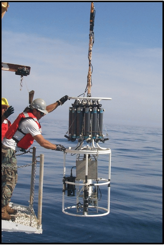
The primary hydrographic data presented here were collected with Seabird CTD systems (Figure 4). The Seabird 911+ CTD (SBE911+) provides measurements of pressure, temperature, conductivity, and fluorescence and records at a rate of 24 observations per second. This CTD is equipped with a rosette (Seabird 32 carousel) for collecting water samples at selected depths. Bongo hauls were made at each of the stations occupied. A Seabird model 19 profiling CTD (SBE19 Profiler) was used on each bongo tow to provide depth information during the tow. The Profiler records pressure, temperature and conductivity observations twice per second.
The following is a list of the CTD data collected with each of the sampling systems used on the cruise:
Instrument # casts
SBE911+ 41
SBE911+ calibration 41
SBE19/ Bongo 41
SBE19/ calibration 7
The SBE911+ was deployed with 10 bottles on the rosette and samples were collected for various investigators. Samples were collected for oxygen isotope analysis at selected depths (R. Houghton, LDEO) and a sample was taken at the bottom for calibrating the instrument=s conductivity data (D. Mountain, NMFS). Samples for chlorophyll and nutrient analysis were taken from multiple depths at each of the standard stations (D. Townsend, Univ. of Maine). Surface samples were taken at Afull@ stations for phytoplankton species composition (J. O=reilly, NMFS).
Parameter # samples
oxygen isotope 141
Species composition 21
Data:
Preliminary processing of the SBE Profiler and 911 data was completed at sea using the Seabird manufactured software routines to produce 1 decibar averaged ASCII files.
At standard station #4, we began what would become a three-day battle with sea cable terminations, splices, and slip rings. The CTD would not power up through the sea cable on the oceanographic winch but worked fine on a test cable (which completely bypasses the sea cable). While Electronic Technician Henry Jenkins investigated the problem, we moved the CTD out to the main deck for deployment off the boom. The CTD cast was successful but we did notice some noise in the data. Upon attempting the 1-m2 MOCNESS at this station, an error message declared that the sea cable was open. Now, both the oceanographic winch and the boom cables were inoperable because both required full repairs (cutting, re-pouring, and re-splicing).
The boom wire was first to be put back online. However, when we deployed the CTD, we still were seeing intermittent noise in the signal (the Seabird Profiler and MOCNESS operations did not have this). We concluded that because the sea cable on the boom was in such poor condition (rust and wires unraveling), the signal for the 911 CTD was breaking down. We needed to move back to the oceanographic winch. When this termination was repaired, we tested the CTD once again and much to everyone=s dismay, it did not power up. The problem was in the slip rings. Henry took the slip rings out and discovered that they were severely corroded. An older, Aspare@ set of slip rings were put in place which allowed us to finally get signal from the CTD, but it did cause a fair amount of signal noise. As a result, preliminary data processing for this cruise was rather labor intensive. Final cleaning of the data errors will be completed back in Woods Hole.
Results:
The hydrographic figures presented here were generated prior to the occupation of station 38. The contoured anomalies have been calculated using the MARMAP hydrographic time series as a reference. The surface and bottom temperature and salinity distributions are shown in Figure 5. Temperature and salinity anomalies are shown in Figure 6. Stratification in the upper 30 meters of the water column and the stratification anomalies were also calculated. These distributions, expressed in sigma-t units, are shown in Figure 7 (left). The distribution of fluorescence (expressed in volts) is shown in Figure 7 (right).
The volume average temperature and salinity of the upper 30 meters were calculated for the four sub-regions shown in Figure 8. These values are compared with characteristic values that have been calculated from the MARMAP data set for the same areas and calendar days. The volume of Georges Bank water (salinity < 34 PSU) was also calculated and compared against the expected values. A CTD profile is provided for each standard station with a compressed listing of the preliminary data in III.
Hydrographic conditions on the Bank were warmer and slightly fresher than expected for mid-June. The surface temperatures at the central, well mixed portion of the Bank ranged between 11 B 12 deg. Celsius while those along the southern flank were between 13 - 20.5 deg. Celsius We sampled portions of a Gulf Stream Warm Core streamer (as we did during the May survey) with the highest temperatures and salinities (over 35 psu) observed at standard stations 15 and 17. A very strong temperature and salinity gradient (13 degrees and 3 psu respectively) existed at station 17 between 20 to 40 meters. The large negative anomaly of AGeorges Bank water@ shown in Figure 8 is due to the Gulf Stream intrusion observed predominately in the southeast region. We did not download satellite imagery during the survey, but will review the archived imagery for this cruise period upon return to Woods Hole.
Despite the presence of the warmer, more saline water along the
southern flank, all four regions of the Bank were slightly fresher
than expected (Note that the calculations shown in Figure 8 exclude
water with salinity greater than or equal to 34 PSU). Lowest
surface salinities on the Bank were observed at station 21. This
may be remnant Scotian Shelf water that has been observed here on
the previous surveys. The trend of relatively lower salinities has
been observed since early in 1997. Although this is the last GLOBEC
Broadscale survey, the Northeast Fisheries Science Center conducts
survey cruises nearly year round collecting over 2000 CTD casts
along the Northeast Shelf (including Georges Bank). It is possible
to continue to monitor this negative anomaly in salinity on Georges
Bank. Data from these cruises are available at an anonymous FTP
site maintained by the Fishery Oceanography Investigation
(ftp.wh.whoi.edu).
The temperature and salinity at station 25 (eastern side of the
Northeast Channel) was warmer (12 deg C) and saltier ( > 32.5
PSU) than was expected. We did not cross over to AScotian Shelf@ water at this station. It is not known
at this time (because we have not reviewed any satellite imagery)
whether or not there is any Gulf Stream feature located toward the
south that could be pumping warmer, more saline water through the
Northeast Channel.
Zooplankton and Ichthyoplankton studies based on Bongo and
MOCNESS tows.
(John Sibunka, James Pierson, Stephen
Brownell, Neile Mottola, Ryan Campbell, and Joshua Frederickson)
Objectives:
(1) Principle objectives of the ichthyoplankton group in the broad-scale part of the U.S. GLOBEC Georges Bank Program were to study the composition of the larval fish community on Georges Bank, to define larval fish distribution across the Bank and within the water column, to determine those factors which influence their vertical distribution, and to determine bank-wide versus "Patch-Study" mortality and growth rates. Emphasis in this study is on cod and haddock larvae along with their predators and prey. This study also includes larval distribution and abundance, and age and growth determination. These objectives were implemented through use of bongo net and 1-m2 MOCNESS to make the zooplankton and ichthyoplankton collections. A 10-m2 MOCNESS was used to collect larger pelagic invertebrates and juvenile fish.
(2) The primary objective of the zooplankton group was to complete a bank-wide survey of Georges Bank to determine the distribution, abundance, and stage composition of the target species Calanus finmarchicus and Pseudocalanus spp. A second objective was to identify, quantify, and describe the occurrence of abundant non-target species in order to provide a description of the environment occupied by the target species. These objectives were implemented by using the 1-m2 MOCNESS for sampling copepods and larger zooplankton. A Jelnet cast was made to collect gelatinous predators and a submersible pump was deployed for sampling the small copepod naupliar stages.
In addition to these objectives, the zooplankton group was responsible for obtaining subsamples from the 1-m2 MOCNESS hauls for population genetic studies of Pseudocalanus spp. to be completed by Dr. A. Bucklin at the University of New Hampshire.
Methods:
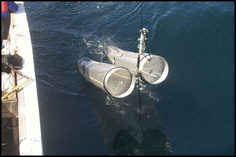
Bongo tows were made with a 0.61-m frame fitted with paired 335 mm mesh nets (Figure 9). A 45 kg ball was attached beneath the bongo frame to depress the sampler. Digital flow meters were suspended in the mouth of each net to determine the volume of water filtered. Tows were made according to standard MARMAP procedures, (i.e., oblique from surface to within five meters of bottom or to a maximum depth of 200 m while maintaining a constant wire angle throughout the tow). Wire payout and retrieval rates were 50 m/min and 20 m/min respectively. These rates were reduced in shallow water (<60 m) to obtain a minimum of a five minute tow or reduced due to adverse weather and sea conditions. A Seabird profiler CTD was attached to the towing wire above the frame to monitor sampling depth in real time mode and to measure and record temperature and salinity. Once back on board, the 335 mm mesh nets were rinsed with seawater into a 330 mm mesh sieve. The contents of one sieve were preserved in 5% formalin and kept for ichthyoplankton species composition, abundance and distribution. The other sample was preserved in 95% ethanol and kept for age and growth analysis of larval fish. The same preservation procedure was followed as for the 1-m2 MOCNESS.
The 1-m2 MOCNESS sampler was loaded with ten nets (Figure 10). Nets 1-4 were fitted with 150 mm mesh for the collection of older and larger copepodite and adult stages of the zooplankton. Nets 0, and 5-9 were fitted with 335 mm mesh for zooplankton (nets 0 and 5) and ichthyoplankton (nets 6-9) collection. Tows were double oblique from the surface to within 5 m from the bottom. The maximum tow depth for nets 0, 1 and 5 was 500 m, and for net 6 was 200 m (if net 5 was sampled deeper than 200 m, it was returned up to 200 m and closed). Winch rates for nets 0-5 were 15 m/min and for nets 6-9, 10 m/min. The depth strata sampled were 0-15 m, 15-40 m, 40-100 m, and >100 m. The first (#0) and sixth (#5) nets were integrated hauls. For shallow stations, with only 2 or 3 of the depth strata, not all nets were fished. The contents of nets 0-4 were sieved through 150 mm mesh sieve, subsampled using a 2-L plankton sample splitter if the final biomass volume was too large for one quart jar, and then preserved in 10% formalin. Samples from nets 5-9 were sieved through 330 mm mesh sieve and preserved in 95% ethanol. After 24 h of initial preservation, the alcohol was changed. The used ethanol was retained for disposal or recycling ashore. At priority 1 and 2 stations and at station 40, 100-ml subsamples were taken from nets 1-4 (150 mm mesh) and preserved in 10% formalin for Dr. C. Miller (OSU). At priority 1 and 2 stations, 100-ml subsamples from nets 1-4 were removed and preserved in 95% ethanol. At most priority 3 and 4 stations, a 100-ml subsample from the15-40 m net was removed and preserved in 95% ethanol. These samples were collected for Dr. A. Bucklin for population genetic studies to distinguish the Pseudocalanus species found on Georges Bank.

The 10-m2 MOCNESS was loaded with five 3.0 mm mesh
nets (Figure 11). Tows were oblique from surface to ~10 m from
bottom or a maximum depth of 500 m. The same depth strata were
sampled as with the 1-m2 MOCNESS. At most stations
where the water depth was <100 m, net 1 was fished horizontally
at maximum wire out until 4,000-5,000 m3 of water was
filtered; whereby this net was closed and net 2 opened. Nets 2-4
were fished vertically according to standard protocol. The winch
rate for vertical retrieval varied between 5 and 20 m/min depending
on the depth stratum. The slow winch rates were used in order to
filter at least 4,000-5,000 m3 of water per depth
stratum sampled. A stepped oblique tow profile during retrieval
was used to achieve this, if needed. Catches were sorted for
larval and juvenile cod and haddock. Specimens were preserved in
95% ethanol. The remainder of the sample was sieved through a 330
mm mesh, and preserved in 10% formalin.
When net 1 was fished horizontally near bottom, the sample from
this net was sorted for gadids which were preserved in 95% ethanol;
the remainder of the catch discarded.
A gasoline powered diaphragm pump was used to collect nauplii and younger, smaller copepodite stages of zooplankton (Figure 12). The intake hose was deployed off the port side hydro boom by affixing two release shackles to the end of the hose and clipping them to the hydro wire above and below a niskin-bottle clamp. The clamp was positioned on the winch wire above the end of the termination to keep the hose from falling down on the termination as the wire was raised during retrival. The winch meter block was zeroed at the surface and the wire out reading was used to determine the depth of the cast. Two 45 kg weights was used to depress the array. Two to four 30 m sections of 7 cm diameter hose were connected to the pump, allowing the intake hose to attain a maximum depth of approximately 100 m. At shallow stations (<100 m), the intake nozzle was lowered to 3-5 meters off the bottom. The discharge end of the hose was diverted to a surge dampener before it entered the collection net. This caused the flow to be laminar as it passed the flow meter, allowing a more accurate measurement of flow rate. Once the hose had been deployed to the desired depth it was raised at a constant rate and samples collected. Wire retrieval rate was approximately 4 m/min which provided volumes of about 200 L per 5 m depth interval. Sampling depths were from the maximum depth to 75 m, 75-40 m, 40-15 m, and 15 m to the surface. The hose was allowed to flush for a predetermined interval before collection began, before each net change, and once the hose had reached the surface. Flushing time was calculated based on the flow rate of the pump and depending on the length of hose used at each station. The three or four integrated depth samples were collected with 30 mm mesh nets, sieved through a 30 mm mesh sieve and preserved in 10% formalin.
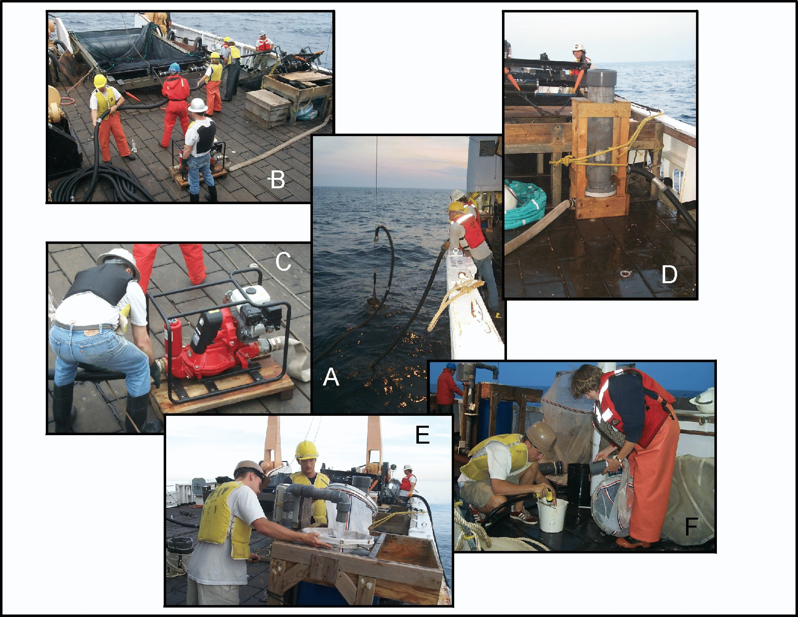
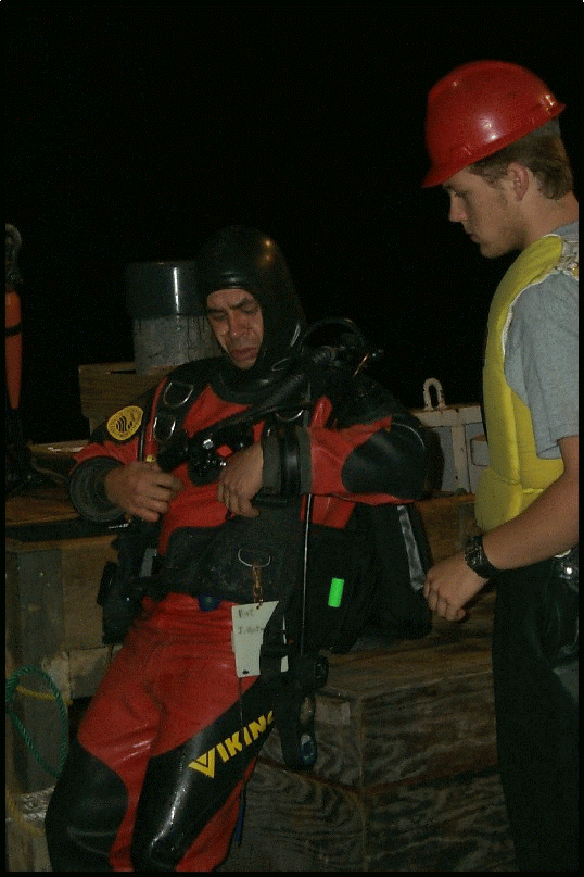
At standard station 34, the pump hose fouled on the propellor shaft after sampling was completed. Divers (William Amaro and Cecile Daniels) were sent to clear the shaft and approximately 40 meters of pump hose were lost. There was 24 m of spare hose on board, for a total of 104 m, so operations continued normally.

A 1-meter diameter Reeve net sampler was used to collect live specimens of Calanus finmarchicus (Figure 13). The cylindrical metal ring forming the aperture of the sampler was fitted with a 335 mm mesh net 4.0 m in length. Affixed to the cod end of the net was a PVC collection bucket 46 cm tall and 33 cm in diameter with screened ports. This collection bucket was supported by four nylon lines attached to the net mouth ring. Vertical tows were made from surface to within 10 m of bottom, or to a maximum depth of 200 m. The net was deployed at a winch rate of about 10 m/min and retrieved at a rate of 5 m/min. Depth of cast was determined by the actual wire out. Depression of the net was obtained by both filling the collecting bucket with sea water prior to deployment and also by the addition of between one to six 5-lb (2.3-kg) lead dive weights depending on sea conditions. The animals caught in the cod end bucket were gently released into 5 gallon plastic pails previously filled with seawater using the ship's sea chest. Preliminary analysis of the live organisms collected from the catch was done on ship board. After the catch was examined, the sample was preserved in 5% formalin.
Samples Collected by the Zooplankton and Ichthyoplankton Groups:
Gear Tows Number of Samples
1. Bongo nets, 0.61-m 41 tows 42 preserved, 5% formalin
335-mm mesh 41 preserved, EtOH
2. MOCNESS, 1-m2 41 tows
150-mm mesh(Nets 1-4) 126 preserved, 10% formalin
335-mm mesh(Net 0) 41 preserved, 10% formalin
335-mm mesh(Nets 5-9) 171 preserved, EtOH
3. MOCNESS, 10-m2 33 tows
3.0-mm mesh 140 preserved, 10% formalin
4. Pump 19 profiles
35-mm mesh 64 preserved, 10% formalin
5. Jelnet 10 tows
5-mm mesh 8 preserved, 10% formalin
6. Reeve Net 9 tows
335-mm mesh 9 preserved, 5% formalin
Preliminary Summary of Ichthyoplankton Findings.
(John Sibunka)
During the cruise, shipboard samples from all the 5% formalin preserved bongo AB@ nets were observed while in the jar for the presence and estimated quantities of fish larvae and eggs. These quick observations were done in an attempt to obtain a qualitative estimate of the ichthyoplankton abundances, distribution and size ranges on Georges Bank.
American plaice and yellowtail flounder (Hippoglossoides platessoides/Pleuronectes ferrugineus):
Microscopic examination is required to separate American plaice from yellowtail flounder larvae at sizes <16mm standard length (SL). Transformation for American plaice flounder begins at 18.0-34.0mm SL, usually >25mm SL; whereas yellowtail flounder commence transformation at 11.6-16.0mm SL. Since most of these flatfish larvae collected during this survey were less than 15.0mm SL, they were combined into one category. It is likely that the majority of these larvae are yellowtail flounder as the adults of this species on Georges Bank begin spawning later in the spring than American plaice and continue spawning into the summer months.
These fish were the most abundant larvae seen in the bongo plankton catches from this cruise. Their distribution ranged across Georges Bank (Figure 14). The largest catches of larvae were made along the south-central portion of the Bank between the 55m and the 90m isobath lines. The size of the larvae collected ranged from 5 to 16 mm SL, with most specimens between 7 to 12 mm SL. During this June survey small larvae (~5 mm SL) were collected mainly at stations located along the northern portion of the Bank. Larger larvae (10-16 mm SL) were found to be concentrated in the western portion of Georges Bank. The results of this survey are similar to those reported in the1998 broadscale survey in May (refer R/V ALBATROSS IV, Al-9806 cruise report).
Cod (Gadus morhua) and Haddock (Melanogrammus aeglefinnus):
The only cod larvae seen in the bongo plankton samples examined this cruise were at standard stations 2 and 27. An estimated four specimens were collected with an approximate size of 10 mm SL each. No haddock larvae, nor the eggs of either cod or haddock were observed in the bongo catch samples collected on Georges Bank during this June broadscale survey.
These results, which are similar to the results of previous broadscale surveys in June (refer R/V ALBATROSS IV Nos. 9607, 9707 and 9808 cruise reports) indicate that cod and haddock had almost completed spawning in the survey area for this year. Both post larval and juvenile stages of cod and haddock were seen in the 10-m2 MOCNESS samples collected on this cruise (refer 10-m2 MOCNESS catches/station in this report).
Miscellaneous Fish Larvae:
The following fish larvae were also identified in the ichthyoplankton samples collected during this broadscale survey.
1. Sand lance (juvinile) Ammodytes spp.
2. American plaice (>15.0mm) Hippoglossoides platessoides
3. Sculpin Myoxocephalus sp.
4. Silver hake Merluccius bilinearis
5. Sea snail Liparis sp.
6. Lantern fish Myctophidae (Family)
7. Leptocephalus Anguillidae (Order)
8. Windowpane flounder Scophthalmus aquosus
9. Butter fish (juvinile) Peprilus triacanthus
10. Fourbeard rockling Enchelyopus cimbrius
Preliminary Summary of the 10-m2 MOCNESS samples.
(Stephen Brownell)
The samples collected from 10-m2 MOCNESS were examined on shipboard for a qualitative estimate of abundance and distribution. Following is a listing of the species observed in the samples following preservation at standard stations.
Station 3 Haul 1 ctenophores, naked pteropods, hyperiid amphipods, salps, flounder, haddock.
Station 4 Haul 2 ctenophores, flounder.
Station 9 haul 6 ctenophores, pipe fish, flounder, salps, hyperiid amphipodes, ctenophores, cod.
Station 10 Haul 7 ctenophoeres, flounder, cod.
Station 11 Haul 8 ctenophores. (very small sample)
Station 12 Haul 9 pipe fish, lots of macro algae, a few ctenophores.
Station 13 Haul 10 isopods, ctenophores, small shrimp, flounder.
Station 14 Haul 11 isopods, ctenophores, naked pteropods, small shrimp, hyperiid amphipods, puffer fish, flounder, haddock
Station 16 Haul 12 euphausiids, amphipods, naked pteropods, small shrimp, hatchet fish, viperfish, myctophids.
Station 17 Haul 13 salps (21 gallons), pyrosomes, shrimp, pomolobus spp.
Station 18 Haul 14 ctenophores, salps, euphausiid, naked pteropods, cod.
Station 19 Haul 15 ctenphores.
Station 20 Haul 16 ctenophores, flounder, cod.
Station 21 Haul 17 ctenophores, euphausiids, naked pteropods, isopods, flounder, cod, haddock.
Station 23 Haul 18 ctenophores, naked pteropods, flounder, cod.
Station 39 Haul 19 euphausiids, squid, salps, amphipods, ctenophores, lg shrimp, myctophids
haddock.
Station 26 Haul 20 salps, shrimp euphausiids, amphipods, naked pteropods, ctenophores, haddock, hake, alligator fish, cod.
Station 27 Haul 21 ctenophores, amphipods, lion's mane jelly fish.
Station 28 Haul 22 ctenophores, naked pteropods.
Station 29 Haul 23 euphausiids, naked pteropods, ctenophores, salps, amphipods.
Station 30 Haul 24 isopods, ctenophores, shrimp, lion's mane jellyfish, sandlance, haddock.
Station 40 Haul 25 euphausiids, naked pteropods, shrimp, chaetognaths.
Station 31 Haul 26 isopods, naked pteropods.
Station 32 Haul 27 lion's mane jellyfish(4), naked pteropods.
Station 33 Haul 28 amphipods, lion's mane jellyfish, flounder.
Station 34 Haul 29 euphausiids, shrimp, naked pteropods, cod, sandlance, myctophid.
Station 35 Haul 30 euphausiids, ctenophores, amphipods, naked pteropods, sandlance.
Station 36 Haul 31 lion's mane jellyfish (2), euphausiids.
Station 37 Haul 32 ctenophores, chaetognaths, haddock.
Startion 38 Haul 33 euphausiids, shrimp, amphipods, sandlance, ocean pout.
Zooplankton Predator Sampling.

(For L. Madin, S. Bollens and E. Horgan)
The Jelnet is 1.5m2 at its opening and tapers to a shallow 50 cm deep flat bottom which has a collection sock to which a standard MOCNESS cod collar and end bucket was attached (Figure 15). Mesh size of the net is 5 mm (3/16"). The tubular aluminum frame is bridled from each of the corners to a common point above by a 5 mm (3/16") stainless steel wire with thimbles spliced into the wire ends. A 45-kg lead ball is attached to a 13 mm (2@) oblong stainless ring when the net is fished. Vertical tows were made from surface to within 10-15 m of bottom, or to a maximum depth of 100 m. The net was deployed at a winch rate of 20 m/min and retrieved at a rate of 5 m/min. Depth of cast was determined by the actual wire out. The contents of the nets were combined and preserved in 10% formalin and kept for species composition, abundance and distribution.
Zooplankton Observations on AL9906.
(Charles B. Miller)
Zooplankton biomass was very modest over and around Georges Bank in June 1999. We saw the usual separation between stations inside and outside the 60 m isobath. Inside that line the plankton on the filter screens resembled wet sand. I was on night watch, so I saw several night samples from the bank top. In those the brown, sand-like plankton would be polka-dotted with white amphipods. The Asand@ was composed almost entirely of copepodites of Centropages hamatus, Pseudocalanus spp. and Temora longicornis, in that order of abundance. The brown tone comes from the brown pigment banding on most of the C. hamatus. Of course, there was often an admixture of actual sand. I never saw a hydroid polyp on the whole cruise, much less any significant abundance. This is the first time that I have seen substantial numbers of Pseudocalanus over the top of the bank on a recurring basis. Usually they have been present in significant numbers at only a few stations without much pattern. A few samples from this subregion had substantial numbers of juvenile Sagitta elegans, which is a common occurrence in BroadScale sampling, but perhaps less frequent than usual on AL9906.
Plankton on the southern flank and Northeast Peak, outside the 60 m isobath was dominated by Calanus finmarchicus, but in very modest quantities. Small numbers of Metridia lucens were mixed with the Calanus, but never dominant. Sometimes Centropages typicus is part of the plankton on the south flank at this season, but none were seen in 1999. Large pteropods were abundant in the southwest sector of the bank, accompanied by a spectrum of smaller ones down to sand-grain size. The offshore stations (7, 16) were affected by warm core rings, and near-surface temperatures were greater than 20C. This water produced virtually no plankton when sampled by the MOC-1. What there was included a mixture of subtropical species. Only the deepest samples (ca. 350 or more to 100 m) from those stations had any significant amount of plankton, most of it resting stage C. finmarchicus.
Several stations on the south side of the Northeast Peak, as well as Station 25 across the channel on the Scotian shelf, were located in patches of Salpa aspera. At Station 25, for example, we caught 35 drained gallons in one MOC-1 net. It was virtually impossible to separate crustacean and other plankton from the huge mess of salps. We were forced to cancel the MOC-10 haul for risk of not being able to get the loaded nets aboard.
Stations north of the Bank at the edge of the Gulf of Maine (29, 40, 34) were strongly dominated by C. finmarchicus, the bulk of them being in the deepest nets. These were loaded with lipid, clearly resting stages. Much smaller numbers were caught in the surface layers. While resting Calanus dominated the deep plankton, they were only modestly abundant compared to the early years of the BroadScale Survey. In 1995 and 1996, we caught multiple liters of drained Astrawberry daiquiri@, and had to split samples three and four times to get a half liter for preservation. On this cruise we had only a few (two on my watch) samples from single depths that required even one splitting to store. These modest amounts were similar to those captured in 1998. This interannual variation correlates with the salinity anomalies observed by David Mountain on BroadScale cruises, and that correlation has the same sign as observed in MARMAP data over a longer interval (Mountain, personal communication). Refined evaluation of this relationship may be one of the best contributions of the GLOBEC program at Georges Bank. Since salinity is set by the relative importance of deep inflow to the region (more deep inflow installs more salt), a nutrient-driven, bottom-up process is suggested as the source of the correlation. If that proves true, it is a very exciting finding indeed. Large pteropods were absent from the Gulf of Maine stations, but numerous very small ones (0.2 mm) were at the bottom of most sample jars. They did not contribute significant biomass relative to Calanus.
Night hauls of both the 1-m2 MOCNESS and 10-m2 MOCNESS at southern Gulf of Maine stations produced good numbers of Meganyctiphanes, particularly the deepest nets on night hauls. Other than in those samples, euphausiids were rare. There were very few in the offshore stations along the south flank, which has not been typical of other cruises. Presumably the presence of warm-core rings had displaced the usually abundant Slope Water species to deeper water or some other location.
I was successful in finding along the southern flank just over 30 C. finmarchicus C5 with the short, forward-located gonad rudiment type called (provisionally in my laboratory) diapause-2. This type was very rare (1-2%), being far outnumbered by diapause-1 , which is longer and more posterior. These gonad rudiment types are pictured in the April BroadScale cruise report (OC341). I reared the diapause-2 specimens in small containers kept cool by flowing water from the ship=s scientific seawater system. This was not in fact always cool, temperatures rising to 23C when the ship was in some of the warm-core ring water. Surprisingly, the animals survived that well. They were fed particles concentrated from the surface water by filtration. With up to 6 animals in 130 ml, they were certainly all stressed for food. They survived that, too, and continued to make fecal pellets throughout. The specimens were preserved on arrival at Woods Hole and will be examined in Corvallis to see whether ovaries or testes have developed from them. This will be a large addition to our data set regarding this question. We have sufficient rearings of diapause-1 individuals from earlier cruises, most of which develop testes. Because of limited incubation space, only 6 diapause-1 individuals were raised on AL9906.
Egg production rates and gonad development of dominant copepod species
(Barbara Niehoff)
The aim of this study are (1) to describe and classify gonad developement stages of small copepod species dominant on Georges Bank and (2) to relate gonad morphology and egg production rates. In addition, female Calanus finmarchicus were to be collected for experimental work at WHOI in order to study gonad development at food limitation. The study during this cruise continues the work during two previous process cruises in February and April 1999 which was conducted in collaboration with Jeffery Runge.
Zooplankton samples were taken in vertical hauls with a Reeve Net (mesh size 335) at Standard station 7, 11, 15, 18, 25, 31, 35, 38 and 39 from close to the bottom to the surface. Female Centropages spp., Temora longicornis and Calanus finmarchicus were sortetd out immediately after capture. Twenty-four to 36 females of each species were placed individually in multi-well vials containing unfiltered surface seawater. The multi-well trays were kept for 24 h at 10 C in the dark. In 8 h intervals, eggs were counted and removed.
The rest of the samples was preserved in 5% formalin buffered with borax for later gonad stage analysis. As known from previous GLOBEC studies, Centropages spp. and Temora longicornis are abundant on the shallow portions of Georges Bank while Calanus finmarchius is found in deeper water. Correspondingly, sufficient females for incubation and gonad analysis of Centropages spp. and T. longicornis were found at station 7, 11, 18 and 31. More than 70% of the females spawned at these stations. Experiments with C. finmarchicus were conducted at Station 7, 15, 18, 38 and 39. Only 10 to 30% of the females laid eggs within the 24h incubation, except at station 18 where all females spawned. In general, spawning activity and egg production rates were much lower than during February and April. At station 25, zooplankton were too sparce for experiments.
At station 38, approximately 550 female Calanus finmarchicus were sorted for experiments which will be conducted at WHOI. In addition, live Centropages spp. and T. longicornis females were collected at varius stations for histological analysis of the gonad tissue.
Nutrients and Phytoplankton Studies.
(Abigal Dietz and Joanne Lardie - for David W. Townsend University of Maine)
[see also:
http://grampus.umeoce.maine.edu/globec/globec.html]
Overview:
We are collecting water samples on all six broad scale cruises in 1999 (January to June) to analyze for nutrients and phytoplankton biomass. During the June cruise, water samples were collected for analyses of:
dissolved inorganic nutrients (NO3+NO2, NH4, SiO4, PO4);
dissolved organic nitrogen and phosphorus;
particulate organic phosphorus;
particulate carbon, hydrogen, and nitrogen;
phytoplankton chlorophyll a and phaeophytin;
phytoplankton species composition
Alexandrium spp. densities
Methods:
Water collections were made at various depths at all of the regular hydrographic stations (Stations 1 - 41) sampled during the June 1999 broad scale survey cruise aboard R/V ALBATROSS IV, using the 1.7 liter Niskin bottles mounted on the rosette sampler. Additional near-surface water samples were collected at positions between the regular stations (Stations numbered >41) using a surface bucket sampler.
Samples for dissolved inorganic nutrients (DIN) and chlorophyll were collected at all stations, 1-41, and at all the intermediate stations (near-surface). Water samples for DIN were filtered through 0.45 mm Millipore cellulose acetate membrane filters, and frozen in 20ml polyethylene scintillation vials by first placing the vials in a seawater-ice bath for about 10 minutes. Samples will be analyzed following the cruise using a Technicon II AutoAnalyzer. Water samples (50 mLs) for dissolved organic nitrogen, and total dissolved phosphorus (both referred to as DON) were collected at 2 depths (2 and 20m) at each of the main stations and frozen as described above. These samples will be analyzed using a modification of the method of Valderrama (1981). Samples for particulate organic carbon, hydrogen, and nitrogen were collected by filtering 500 mLs onto pre-combusted, pre-ashed GF/F glass fiber filters from 2 depths (2 and 20m) at each of the main stations, wrapped in foil pouches and frozen. The filters will be fumed with HCl to remove inorganic carbon, and analyzed using a Control Equipment Model 240-XA CHN analyzer (Parsons et al., 1984). Samples for particulate phosphorus were collected as for CHN, filtering 200 mLs and freezing in glass petri dishes. Laboratory analyses will involve digesting the sample in acidic persulfate and then analyzing for dissolved orthophosphate.
Phytoplankton chlorophyll a and phaeopigments were measured in discrete water samples collected at all stations (see Appendix II). One hundred mLs of water was collected from each depth down to 100 meters, filtered onto a GF/F filter, and extracted in 10 mLs 90% acetone. The samples were allowed to extract for at least 6 hours, then analyzed at sea using a Turner Model 10AU fluorometer according to the method of Parsons et al., 1984.
Samples for phytoplankton species composition were collected from the surface at stations 1-41 by preserving a volume of 100 mls in Lugol=s solution. These samples will be available for analysis of the larger species using the Uttermohl inverted microscope method.
Alexandrium spp. samples were collected from the surface at standard stations 1-41 and all intermediate stations >41, by preserving a volume of 10 mls with 1 ml 5% buffered formalin. These samples will be analyzed for Alexandrium spp. cell densities using an antibody/antigen fluorescent tag and enumerated under an epifluorescence microscope.
Preliminary Results:
The only data immediately available following the cruise is the chlorophyll data presented here (Appendix II). We have seen a number of interesting phenomenon happening with the water column this cruise. Anomalous surface temperatures and salinity readings have occurred frequently and the chlorophyll values have also reflected somewhat of an erratic pattern. The chlorophyll values ranged from 5.78 to 0.00ug/l. It was noted that the surface temperature throughout most of this survey was up about 12* C. The usual temperature on Georges Bank for this time of year, according to chief scientist Peter Wiebe, is 8 - 10 C. After days of rain some thick layers of fresh water were observed during CTD casts. Please note that a complete table that will correlate chlorophyll data with station number, latitude and longitude will be posted on the web site listed above at a later date.
References:
Parsons, T.R., Y. Maita and C.M. Lalli. 1984. A Manual of Chemical and Biological Methods for Seawater Analysis. Pergamon, Oxford. 173 pp.
Valderrama, J.C. 1981. The simultaneous analysis of total nitrogen and total phosphorus in natural waters. Marine Chemistry 10: 109-122.
Stable Isotope Sampling
(Karen Fisher)
The purpose of this sampling is to determine the extent of temporal and spatial variability in isotopic concentrations of carbon, hydrogen, and nitrogen in several biological compartments: particulates and phytoplankton filtered from water samples; surface plankton caught in 150 and 330 micron mesh nets of the 1-m2 MOCNESS; and macroscopically identifiable species/genera from the zooplankton community.
Sampling occurred at 25 standard stations, averaging every second station. Seventy-five particulate samples were filtered onto GFF or GFD media and frozen from water obtained through CTD bottles, and the flow-through seawater system on the ship. Forty surface samples (whole community) of zooplankton were obtained from 20 stations (nets 4 and 9 at stations shallower than 100 meters). Where found, pteropods were decanted or picked from one of the buckets and frozen separately if time allowed. Shelled pteropods were qualitatively abundant at the first 3 stations (brown, size range averaged >400 microns and <2mm preserved separately at Stations 1, 3, 7, 9, 16, 36, shells only at 34), and on the north-east peak (size range averaged somewhere between 150-400 microns preserved separately at Stations 21, 22, 26, 29, 30, 32). However, adult Clione outnumbered total thecosomatous pteropods at many stations on the northern side of the Bank (preserved separately at Stations 3, 9, 21, 22, 39, 26, 29, 30, 34, 38 along with larvae) . Few of the larger Limacina were obtained after Station 9.
High Frequency Acoustics
(Peter Wiebe and Karen Fisher)
This is the last of three trips in 1999 to make high resolution volume backscattering measurements at 120 kHz and 420 kHz of plankton and nekton throughout the Georges Bank region on the GLOBEC broad-scale cruises. As on the previous broad-scale cruises, work on this cruise was designed to provide intensive continuous acoustic sampling along all the shipboard survey track lines in order to cover the entire Georges Bank region. The data are intended to provide acoustical estimates of the spatial distribution of animals which span the size range of the target species (cod, haddock, Calanus, and Pseudocalanus) and their predators. The spatial acoustical map and the along track temperature, salinity, and fluorescence data are also intended to provide a link between the physical oceanographic conditions on the Bank and the biological distributions of the species as determined from the net collections at the stations distributed throughout the Georges Bank region. Continuous acoustic data between stations can be used to identify continuity or discontinuity in water column structure which can in turn be used to qualify the interpretation of biological and physical data based on the point source sampling.
Methods.
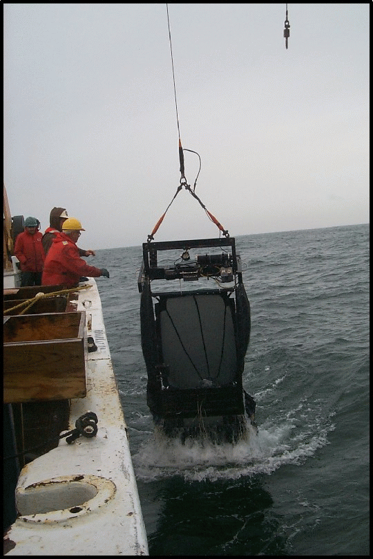
On this cruise, a portion of the R/V Albatross IV chem lab was the operations center for the high frequency acoustics work. The Aacoustics system@ consisted of the AGreene Bomber@, a five-foot V-fin towed body, a Hydroacoustics Technology, Inc Digital Echo Sounder (HTI-DES), several computers for data acquisition, post processing, and logging of notes, plus some other gear. In the Greene Bomber, there were two down-looking transducers (120 and 420 kHz each with 3 degree beams), a multiplexor pressure case for multiplexing the data from the two transducers, and an Environmental Sensing System (ESS). The ESS was mounted inside the V-fin with temperature, conductivity, and fluorescence sensors attached to a stainless steel framework outside of the fiberglass housing. The fish was also carrying a transponder that would have proved useful in locating it if it had happened to break free of the towing cable.
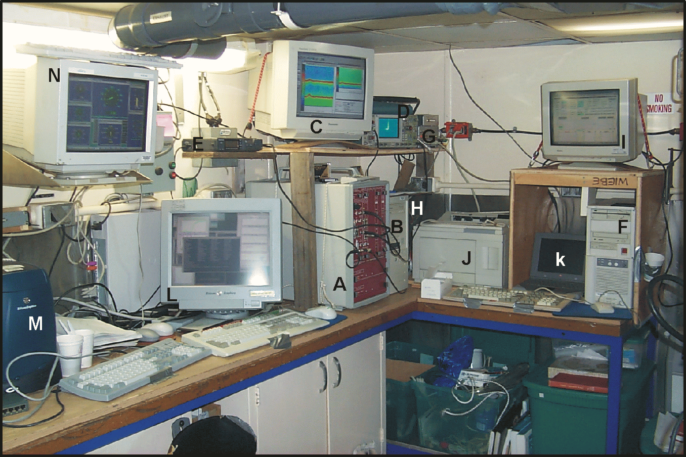
In the lab (Figure 16), the data came in on a single 24 conductor cable with separate shielded groups of wires, one for each transducer and one for the ESS. The HTI-DES has its own computer (a PC104-80486 -100 MHz) and five digital Signal Processor boards (DSPs). It received the data from the transducers, did a series of complex processing steps, and then transferred the results to the Pentium PC over a local area network (LAN) where the data were logged to disk and displayed. The Araw@ unprocessed data were also written to a DAT tape (each tape holds two gigabytes of data) and we used 95 tapes during this cruise - Appendix II. Immense amounts of data were handled very quickly by this system. The environmental data came into a second PC and were processed, displayed, and logged to disk. Both systems required GPS navigation data and those data were being supplied by the ship=s P-code GPS receiver which were logged as part of the ESS data stream. Periodically, the data were transferred to a third computer for post-processing. It was at this stage that we could visualize the acoustic records and begin to see the acoustic patterns that were characteristic of the Bank.

The tow-body was deployed from the starboard quarter of ALBATROSS
and collected data both during and between stations (Figure 17). A
braided steel wire (~0.5") was used to tow the Greene Bomber and the
electrical cable came from the interior of the body and paralleled
the towing wire until a point about 2 meters above the sea surface.
Plastic tubing was wrapped around the electrical cable at five
points starting just about the towing point on towed-body and spaced
about a meter apart. The bottom point was tie-wrapped and taped
directly to the towing wire. The next three points had a carabineer
tie-wrapped to the plastic tubing and snapped onto the towing wire.
About a meter above the final carabineer attachment point, a line
was attached to the electrical cable at the last point and it was
used to put tension on the electrical cable while the Greene Bomber
was in the water. When deploying or recovering the towed body, the
line was released and the carabineers slide down the towing wire to
the top of th e towed body. This provided the clearance needed to
haul the fish up and over the rail of the vessel. A tag line about
15 m in length was attached to the back end of the towed body and
was tied-up short when the ship was working on station to prevent
the towed body from turning 360 degrees and thus tangling the towing
and electrical cables. When steaming between stations, the line was
slacked to maximal extent so that the towed body was not
constrained.

The general towing speed was
about 6.5 to 7.0 kts. The echosounder collected data at two pings
per second per frequency during the cruise. Conditions for
conducting an echo sounder survey of the Bank were ideal during a
good portion of this cruise. There was a period of moderate wind
and the seas shortly after the start of the cruise, but most of the
cruise had light winds and low seas. Overall, the data are of very
good quality and they provide an excellent base from which to
compare the changes in the acoustic field on the Bank as viewed on
subsequent cruises in March and June. We were able to collect
acoustics data along all of the cruise trackline. The length of
trackline acoustically mapped was ~672 nm (1245 km - Figure 18).
Gear Problems
On Saturday, 19 June, Karen Fisher took a look at the Greene Bomber as it was towing along and realized that the electrical cable was looser than normal and that a carabineer that normally held the electrical conductor to the towing wire was loose. We decided that it had to come on board for a check out and replacement of the carabineer. Ken Rondeau worked the winch and J-frame while Tony Veira and Willy Amoro did the handling at the rail. P. Wiebe held the tail tag line and Karen loosened the line putting tension on the electrical cable and holding the carabineer. On board, it was evident that indeed, the carabineer had been sawed through by the action of rubbing up and down along the towing wire. In addition, one of the pins in a shackle holding the safety chain to an eye-bolt on top of the fish was missing (vibrated loose). These were fixed and within about 10 to 15 minutes the Greene Bomber was hoisted up and over the rail and then lowered down into the water to resume data acquisition.
Some Results.
The volume backscattering levels on both the 120 and 420 kHz
transducers were high throughout the water column from Station 1
until reaching the section marked by steaming southeast from Station
12. The pteropod, Limacina retroversa occurred in very large
numbers on much of the Western portion of the Bank (especially in
the Great South Channel) and may have been responsible for a large
portion of the volume backscattering in this region (
Figure 19).
Once out of the well-mixed region and into the stratified waters
(Station 14 to 15 and beyond) on this section, the volume
backscattering below the pcynocline became very low (especially on
the 120 kHz echogram) and this pattern persisted throughout the
northeast peak region. During the first half of the cruise, there
were few echoes from what appeared to be fish. There was a patch of
fish-like echoes in the vicinity of station 8 which the fisherman on
board speculated might have been silver hake (also known as whiting
-
Figure 20). On the northe ast peak region, more targets with
Afish@ characteristics were seen in the
otherwise low backscattering field (Figure 21). The targets looked
like stars on a moonless night sky on the color echogram. The
targets were much more apparent on the 120 kHz echogram than the 420
kHz echogram.
A section of the broad-scale survey trackline that has been
sampled most frequently during the broad-scale years is the one
that runs from Standard Station 8 up to Station 11, over to Station
12 and then down toward Station 14 (Figure
21). The section is one of contrasts that essentially captures
most of the acoustic features have been observed from one
broad-scale cruise to the next. For a good portion of the year,
the water column is stratified on the southern flank of the Bank,
especially in the deeper portions characterized by Stations 8 and
9. The stratification abruptly ceases at the tidal-mixing front
when crossing the 60 to 50 meter isobaths and the water column
becomes well-mixed because of the strong tidal currents. This
happens somewhere in the vicinity of stations 10 and 13. Stations
11 and 12 are always well mixed. The tidal mixing front is the
primary subject of the process oriented GLOBEC work this year. The
volume backscattering data are particularly good at providing a
visual display of the position and structure of the front (Figure 21). The stratification is
characterized in the acoustic imagery by strong scattering in both
the 120 kHz and 420 kHz echograms in the surface mixed layer or in
the pcynocline (where temperature and salinity change rapidly).
The horizontal layering in the stratified waters is often
vertically displaced, sometimes radically, by internal waves or
solitons which are formed in the vicinity of the shelf/Slope Water
break and propagate at 1 to 2 kts up to the tidal-mixing front (as
illustrated below).
However, within the well-mixed area, the acoustic structure on
the echograms is completely different (Figure
22). There is no horizontal acoustic layering (except perhaps
caused by storm induced bubbles right at the surface). Rather there
is a vertical banding of higher and lower volume backscattering that
usually runs from the surface to the bottom. This banding is now
thought to be due to small-scale vertical circulation cells that are
created by the swift tidal flow over a rough bottom. In some
places, the water is moving up to the surface and in others it is
moving down to the bottom. The distances between these upwelling
and downwelling areas may only be 50 to 200 m apart.
While it would be nice if the echoes coming back to the
echosounder were only coming from animals in the water column, any
kind of particle that is present will cause sound to backscatter.
As the fine mesh net tows taken at Stations 11 and 12 dramatically
showed on this cruise, sand can be present in the water column right
up to the surface. The sand is collected best by the
1-m2 MOCNESS with the 150 mm
mesh nets; much less is caught by the 335 mm mesh nets. Thus, the sand grains caught by
the nets have a size that is around 200 mm. From the acoustic point of view, an
individual sand grain of this size is a fairly small target, smaller
than what is easily detectable by the highest frequency on the
Greene Bomber, namely the 420 kHz sound wave. It is almost
invisible to the 120 kHz sound wave. If there were only a few
grains in the water column, they would not be a significant
contributor to the volume backscatter ing. But within the strong
vertical upwelling plumes, the sand grains can occur in the millions
per cubic meter. And numbers count. Blow-ups of the region around
Stations 11 and 12 where the MOCNESS tows were being made show the
plume like structures in some detail (Figure
23). In the highest resolution image (the total distance
traveled during the tow was about 456 meters), the first leg of the
double oblique towyo done by the 1-m2 MOCNESS cuts right
across a very strong backscattering Aplume@ and all of the nets on this towyo-leg
caught large amounts of sand. The relatively lower resolution image
taken at Station 12 that has the trajectory of the 10-m2
MOCNESS (the distance traveled was about 2106 meters) has more Aplumes@. The very coarse mesh (3000 mm) resulted in no sand being caught, but the
nets with finer mesh did catch sand at this station.
The importance of size in contributing to the volume
backscattering can perhaps best be illustrated by subtracting the
volume backscattering recorded at 120 kHz from that recorded at 420
kHz (Figure 24). If most of the particles
in the water column are smaller than those readily visible on the
120 kHz echogram, then the signal at 420 kHz will be larger. If the
particles are sized such that they are equally visible, then there
should be little or no difference. Finally, if the particles have a
gas inclusion or are in fact air bubbles which resonate when hit by
a sound pulse, then it is likely that the 120 kHz backscattering
will be larger. In a Adifference plot@, the top of the Bank in the vicinity of
station 11 shows a very strong Ahot spot@ where the 420 kHz has a much stronger
signal than does the 120 kHz frequ ency. In fact, the entire
well-mixed zone had stronger backscattering at 420 kHz except for a
few isolated areas near the surface which is where lots of white cap
injected bubbles occurred. In the stratified region, very little
difference in backscattering was observed giving rise to the idea
that whatever size distribution of the particles (animals) in the
water column, they were more equally visible to both
frequencies.
As noted above, internal waves and internal solitary waves or
Asolitons@ are characteristic of the stratified
waters of the Bank. The solitons are formed each tidal cycle when
the tide is flowing off the Bank and propagate onto the Bank when
the tide turns. Right from the start of work in the Southeast
Channel wave-like perturbations of the pycnocline were evident in
waters that were stratified. For the most part these were waves of
depression, that is, the density interface (pycnocline) separating
the thinner surface mixed layer from the thicker lower layer moves
downward from its equilibrium position as the wave passes. However,
if there is a pycnocline closer to the bottom than the surface,
waves of elevation can be created i.e. the lower layer is displaced
upward towards the surface. While most of the stratified waters had
the pycnocline closer to the surface, on the southern flank in the
vicinity of stations 5 to 9 , a warm-core ring off shore in the
Slope Water was strongly affecting the surface water structure and
there was also an intrusion of Slope Water up onto the Bank. This
set up a situation where there was a pycnocline near the surface and
also one near the bottom. The acoustic records along the trackline
in this region revealed a complex set of waves, some most intense
near the surface and others more intense along the near bottom
pycnocline (Figure 20). Another dramatic
image of a pair of solitons was observed during the steam along the
trackline between stations 14 and 15 (Figure
25). This feature was very unusual in that the soliton
structure was very complex suggesting that the waves might have had
different origins and we were observing them where they were close
to crossing. Further, the volume backscattering in the near surface
structure of the waves was much stronger at 120 kHz than 420 kHz
indicating that a significant source of the backscattering may have
been from micro-scale density contrasts i n the water column caused
by turbulence rather than particles (animals) present in the water
column.
The spatial patterns
illustrated by these acoustic images provide insight into the
ecological factors that are important in shaping the distribution of
plankton on the Bank. They also provide a means of evaluating the
coherence of the spatial pattern which in turn should help determine
the representativeness of the samples taken with nets at the
broad-scale stations.
Greene Bomber Environmental Data AL9906
The
completed Environmental Sensing System trackline obtained by Greene
Bomber made 189,958 measurements of temperature, salinity, and
fluorescence (Figure 26). In some
regions, remarkable adherence to an inverse correlation between
fluorescence and temperature is evident; in others, it just as
clearly breaks down. Notable features of the plot include the now
familiar sharpness of the surface fronts, the changes in variability
of the fluorescence data, and the large range in temperature
observed particularly on the Southern flank (approximately first
half of the record) where an intrusion of anomalously warm water was
observed. The position and steepness of this June=s Fluorescence front occurred
principally at the tidal mixing front that separates stratified
waters on the Bank flanks from well-mixed waters on top of the Bank
(Figure 27).
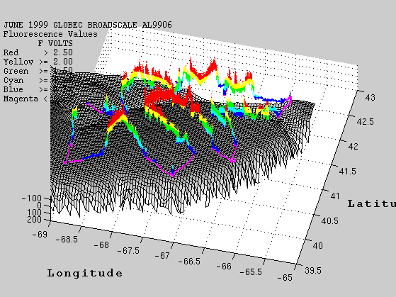
Having a very complete record of
surface fluorescence from June 1998 available for comparison to this
year=s track, we plotted
the fluorescence for both years, using linear color breaks (Figures
28 & 29). The overall impression is that the two years are
quite similar, in contrast to March 1999/1998, which showed nearly a
complete reversal in position of high and low values between the two
years. Notable June departures include: the location of highest
fluorescence (4-5 volts), Southern flank between stations 10 and 13
this year, Northern flank between 29 and 31 last year; lower
fluorescence between Stations 17 and 20, 35 and 37 this year; and
higher fluorescence between Stations 20 and 23 this year.
Additional fluorometer data will be analyzed in the near future from
the CTD casts, the ship=s
flow through system, and a newly installed Fast Repetition Rate
Fluorometer on the hurricane deck of the ALBATROSS IV.

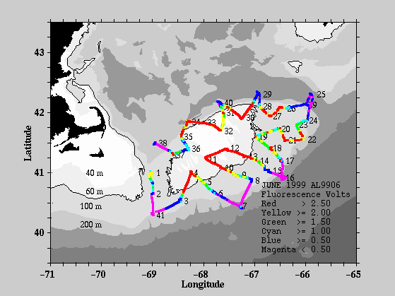

Drifter Deployments.
As part of the physical oceanographic studies of the current structure and circulation on Georges Bank being conducted by R. Beardsley and R. Limeburner, GLOBEC Drifter Buoys are deployed at strategic locations periodically throughout the year to track the Lagrangian flow from the point of deployment. This drifter is constructed with a holey sock drogue (a Dacron cylinder 90 cm diameter by 3 m tall with 5 circular hoop stays) at the bottom. The drogue is connected by either a 10 m or a 40 m cable to a small float (18 cm diameter) which in turn is connected by about 2.6 m of cable to a larger spherical surface float (about 32 cm diameter - Figure 30). The surface float contains a sea surface temperature sensor, a GPS receiver, and an ARGOS satellite transmitter. Temperature, time, and position data are transmitted periodically to shore through the ARGOS telemetry system. On this cruise, three pairs of drifters and a single were deployed. One pair was deployed at Station 28 and the other two pairs were deployed several miles apart as we steamed towards Station 29. Each pair had one 1-m diameter holysock 10-m drogue and one 2-m diameter 40-m drogue. The single 1-m diameter drogue with a 10-m tether was deployed at the end of the work at Station 38.
Shipboard ADCP (Acoustic Doppler Current Profiler) measurements.
No ADCP measurements were logged on this cruise.
CRUISE PARTICIPANTS
Scientific Personnel
1. Peter H. Wiebe Woods Hole Oceanographic Institution
2. Barbara Niehoff Woods Hole Oceanographic Institution
3. Maureen Taylor National Marine Fisheries Service, Woods Hole
4. John Sibunka National Marine Fisheries Service, Sandy Hook
5. Stephen Brownell National Marine Fisheries Service, Narragansett
6. Josh Fredrickson University of Rhode Island
7. Ryan Campbell University of Rhode Island
8. James Pierson University of Rhode Island
9. Niele Motola University of Rhode Island
10. Charles B. Miller Oregon State University
11. Abigale Dietz University of Maine
12. JoAnn Lardie Maine Department of Marine Resources
13. Karen Fisher Cornell University, New York
14. Benjamin Carr Cornell University, New York
Officers and Crew
1. Derick Sutton Captain
2. Cecile Daniels Executive Officer (XO)
3. David Zezula Field Operations Officer (FOO)
4. Kevin Cruise Chief Mechanical Engineer.
5. John Hurder 1stAssistant Engineer
6. Robert. Wint Junior Engineer
7. Orlando Thompson Engine Utility
8. Theopolus Gibson Wiper
9. Kenneth Rondeau Chief Bosun
10. Tony Alvernaz Lead Fisherman
11. Williiam Amaro Skilled Fisherman
12. Tony Veira Skilled Fisherman
13. John Saunders Skilled Fisherman
14. Anthime Brunette Fisherman
15. Doug Roberts Fisherman
16. Richard Whitehead Chief Steward
17. Jerome Nelson 2nd Cook
18. Henry Jenkins Electronic Technician
APPENDIX IV. CTD profiles.
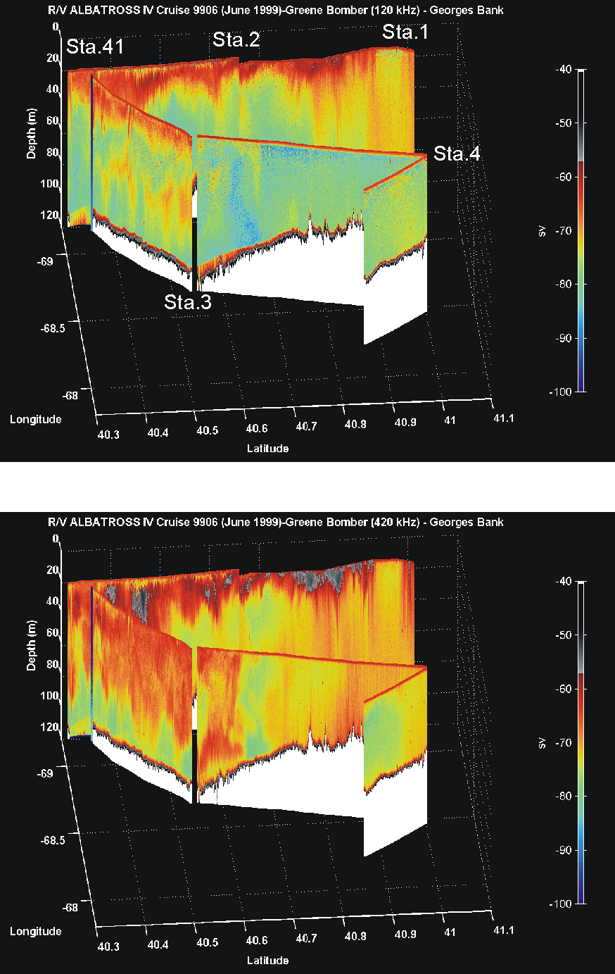
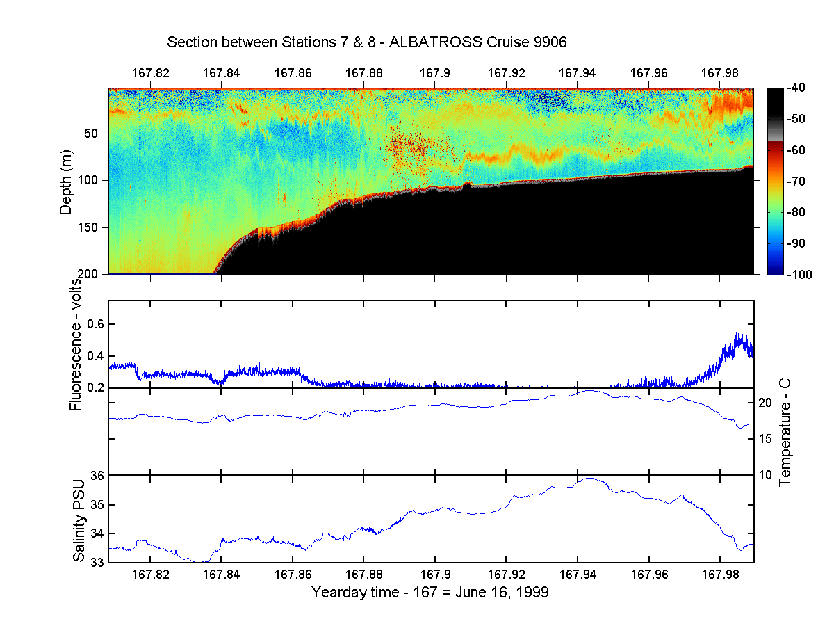
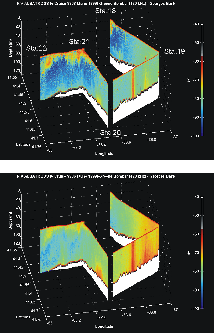
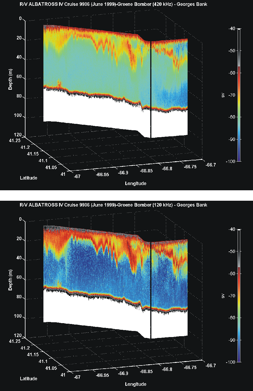