NOTE: Some tables still need reformatting for Web.
Currently
displays much better under Internet Explorer than under Netscape.
DWS, 2 October 2000.
*********************************************************************
REPORT ON C.C.G.S.
Cygnus CRUISE 98-079
23-31 March 1999
by
Peter C. Smith and Gary L.
Bugden
Ocean Sciences Division
Bedford Institute of
Oceanography Dartmouth, Nova Scotia
and
Jackie Spry
Sprytech Biological
Services, Inc.
CANADA
August, 1999
BEDFORD INSTITUTE OF OCEANOGRAPHY CRUISE REPORT Cygnus
98-079
Local Cruise Designation: 98-079
Vessel: C.C.G.S.
Cygnus
Dates: 23-31
March, 1999
Area: Southwest
Nova Scotia/Georges Bank
Responsible Agency: Ocean Sciences Division
Maritimes
Region, DFO
Ship's Master: Capt. M. Champagne
Scientific Personnel:
P.C.Smith Ocean
Sciences
M. Scotney Ocean
Sciences
G. Bugden Ocean
Sciences
B. Nickerson Ocean
Sciences
J. Spry Sprytech
Biological Services, Inc.
1. PURPOSE
The scientific objectives of
this cruise were:
·
Survey the distribution of temperature, salinity, nutrients, and
biological content of a cross-over event between Browns and eastern Georges
Bank,
·
Lagrangian measures of surface drift on Browns and eastern Georges
Banks.
The activities
planned for the cruise period include:
¨
Conduct CTD survey of a cross-over event off SWNS and eastern Georges
Bank,
¨
Make a series of biological measurements on Browns, Georges and
offshore,
¨ Conduct
monitoring activities at Halifax STN 2.
¨ Deploy an LTTM
mooring off Ketch Harbour, N.S.
2. NATURE OF DATA GATHERED
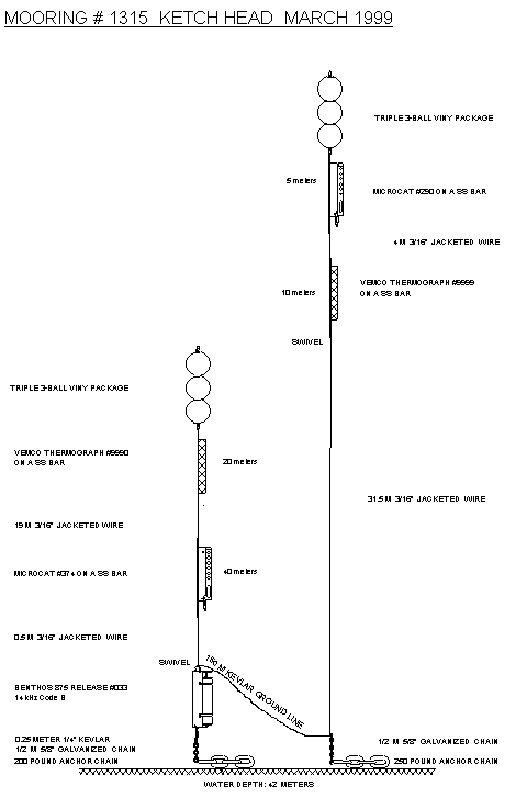
A double LTTM
mooring (Fig.1a; Table 1) was deployed in shallow water (~40 m) off Ketch
Harbour. The mooring carried two
MicroCat T,S recorders at 5 and 40 m and two Vemco temperature recorders at 10
and 20 m. The two mooring legs were
connected by a 150m Kevlar groundline.
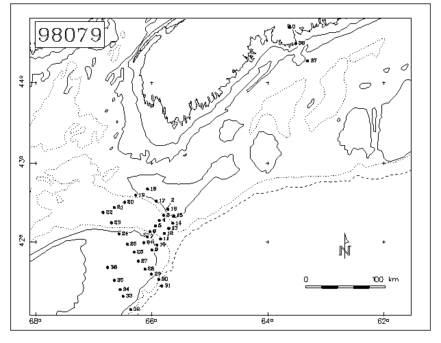
A total of 38 CTD
stations (Fig.1b, Table 2) were occupied in the vicinity of Northeast Channel,
primarily along the following sections:
1) Section Ia - across Northeast
Channel from Browns to Georges Bank on the mooring line, i.e. near the sill
(Fig.3),
2)
Section Ib - across Northeast Channel from Browns to Georges Bank south of the mooring line, i.e. toward the
mouth (Fig.4),
3)
Section II – along the western edge of Browns Bank (Fig.5),
4)
Section III - from Browns to the centre of Georges Basin (Fig.6),
5)
Section IV - across the eastern tip of Georges Bank (Fig.7), and
6)
Section V – across the southern flank of Georges Bank (Fig.8).
In addition to these sections, single stations were taken at the monitoring site (STN 2) off Halifax and at the mooring site.
The quality of
the CTD salinity measurements is quite acceptable (Table 2a), especially
considering the relatively high variability of the standards used. The YSI dissolved oxygen sensor was
calibrated to match surface saturation conditions at the temperature and
salinity measured there by the CTD. In
addition to these offsets, the YSI sensor exhibited occasional noise, spikes,
and hysteresis between the up- and downtraces.
Biological
measurements were taken at a total of 10 stations in the southwest Nova
Scotia-Georges Bank area (Table 3a) and the Halifax Station 2 monitoring site
was occupied on return to BIO (Table 3b).
Nutrient, chlorophyll and salinity samples were variously drawn at
roughly standard depths (0,10,30,50,70 m), and plankton samples were taken with
double-oblique bongo hauls to 50 m in shallow water (<100m) or a vertical
ring net cast in deeper regions.
Samples from one of the bongo nets was preserved in formalin; samples
from the other were preserved in alcohol for genetic analysis at Dalhousie U.
(Chris Taggart).
Surface sampling
of temperature, and salinity was undertaken along the ship’s track using
Biological Oceanography’s flow-through system.
Except for occasional freeze ups and periods of high noise during rough weather,
this system provided continuous surface data over the entire cruise. The calibration of the flow-through
measurements against surface values from the CTD show some offsets (Fig.2b,
Table 2b)
For the Lagrangian experiment, two WOCE drifters with drogues at 10 m were placed at the suspected origin of the cross-over event on Browns Bank (Table 4). The first was deployed at the Browns end of Section Ia, following station CTD16. The second was placed further into the Gulf along the ~100m isobath, following CTD17 (Fig.1b)
3. PROGRAM SUMMARY
Date From(UTC) To(UTC) Operation
23 Mar. 1200 1900 Depart
BIO enroute to Stn.2 monitoring site
1900 0130(24) Return to BIO for gyro repairs
24 Mar. 0130 1300 Depart
BIO enroute to NE Channel line
1300 1800 CTD2-8 on Section Ia
1900 2330 CTD9-15 on Section Ib
25 Mar. 0050 0500 CTD16-18
on Browns, Section II, biological
sampling,
deploy 2 drifters
0530 0930 CTD19-21 on Section III across
Georges
Basin
0930 2000 Engine breakdown (dirty fuel
tanks), head to
Shelburne
26 Mar. 2000 2200(29) Repairs
in Shelburne
29 Mar. 2200 0800(30) Depart
Shelburne for Georges Basin
30 Mar. 0800 1930 CTD22-31
on Section IV, biological
sampling
2220 0230(31) CTD32-36 on Section V
31 Mar. 2000 2100 CTD37,
biological sampling at STN2
2230 2315 CTD38; LTTM mooring placement in
Ketch
Harbour
1 Apr. 0100 Arrive BIO
4. MOORING OPERATIONS
Foul weather prevented the
deployment of the Ketch Harbour on leaving BIO, but conditions were favorable
upon return. Two locations in shallow
water (~40 m) were identified and the ship maneuvered over the first as the
floats and instruments were fed over the side.
The anchor was lowered to the bottom on the groundline. When the groundline was taut, the second
anchor was slipped to the bottom as the second set of floats and instruments
were payed out. The anchors ended in
nearly the intended positions.
5. HYDROGRAPHIC/BIOLOGICAL MEASUREMENTS
Hydrographic measurements, including dissolved oxygen, were made at a total of 37 stations (Table 2) using a Seabird 25 portable CTD system, equipped with a SBE 23Y Yellow Springs Instruments (YSI) dissolved oxygen sensor. The data were recorded internally and downloaded periodically to a laptop PC which processed them into ODF files.
In addition,
biological measurements, including 1) double-oblique Bongo casts to 50 m in
shoal waters (<100m); 2) ringnet casts to the bottom in deeper waters
(>130m), and 3) bottle casts for nutrient, chlorophyll, and salinity samples
(see Table 3a,b.). The bottle casts
generally took samples at some subset of standard depths (1, 30, 50, 70, 100,
150, 200, 300m). All of this work was
performed with the “trap-hauler” winch and Hyab crane located on the foredeck
of the ship. The only difficulties
arose when trying to read the dials on the metering block at night, but this
was not a major problem.
The surface
properties of the ocean (T and S) were monitored underway using Biological
Oceanography’s flow through system. Because of the short leadtime for installing
this system, it appears that the wrong calibration coefficients were used. This resulted in surface salinity readings
that were too high by roughly 1.5.
Another problem was the coating of the conductivity cell and surrounding
tubing with a metallic substance (e.g. rust?) from the sea water line. This plating undoubtly affected the
conductivity/salinity calibration as well.
Nevertheless, the sharp changes in salinity at fronts were detected,
allowing us to define our sampling criteria.
Finally, because of the passage of the seawater line through the ship,
the temperatures recorded by the flow-through system tended to be a bit higher
(~1oC) than those surface values from the SeaBird (Fig.2b).
Problems/Recommendations:
1.
Better (ie.
cleaner) pumping for the flow-through surface sampling system is required. A
separate pump may be necessary for greater stand-alone reliability.
2.
Ship
Problems: ship’s gyro shut down,
required resetting; sludge in the fuel tank should be eliminated.
3.
COS should
develop its own flow-through system, so that the calibration and other problems
may be fixed at sea with a minimum of lost data.
5a. Processing
The data from the portable SeaBird system were downloaded to a laptop computer after every 3-4 stations, and then processed into ODF files for archiving. The following is a summary of the processing procedure:
1) Convert raw frequency data to binary pressure, temperature, conductivity, etc. using SEABIRD's DATCNV program.
2) Align downcast pressure, temperature and conductivity using SEABIRD's ALIGNCTD program by advancing the conductivity signal by 0.073 sec. Also advance oxygen temperature and oxygen sensor current by 3 seconds.
3) Filter downcast
pressure using SEABIRD's FILTER program. This is a low pass filter and we used
a time constant of 0.5 seconds.
4) Mark downcast
scans where the CTD is moving less than the minimum velocity of 0.01 m/s using
SEABIRD's LOOPEDIT program.
5) Compute salinity
and dissolved oxygen in ml/l using SEABIRD's DERIVE temperature
6) Plot salinity and
dissolved oxygen vs. pressure using SEAPLOT program.
7) Bin average
downcast data to 0.5-dbar intervals using SEABIRD's BINAVG program.
8) Convert the down
cast from binary to ASCII using SEABIRD's TRANS program.
9) Convert downcast
to ODF format using OSD program SEAODF25.
10) Create IGOSS
message using OSD program ODF_IGOS.
Plots and status info
displayed by the SEASAVE program during the acquisition are discarded when the
program terminates. The post-processing
plotting was not included in the batch job because SEABIRD's SEAPLOT program
requires interactive operator attention.
Plots produced after each station include T, S, O2, and sq vs. pressure and T vs. S. Section plots were produced with Igor
Yakashev’s contour package, modified to compute sq and to accept .ODF files.
5b. Calibration
Because of the nature of
this operation (“rapid response”) and difficulties with loading associated with
the PSAC strike, the usual calibration standards were not maintained for this
mission. For selected CTD casts,
salinity samples was drawn from an
associated bottle cast were later analyzed at BIO and used to calibrate the
CTD (Table 2a). The relatively high
mean offset and large standard deviation for this calibration is due, at least
in part, to the difficulties of matching times and depths of the measurements
in regions of high gradients.
Similarly, selected salinity samples were drawn from the flow-through
system to assess its performance (Table 2a).
The flow-through properties were also compared to the near-surface CTD measurements
(Fig.2b; Table 2b). In addition,
duplicate nutrient samples were taken from the Nisken bottles to analyze the
accuracy of replicates (Table 2a).
Finally, although there were no dissolved oxygen samples taken, the
general accuracy of the YSI sensor was assessed by assuming that the surface
values are saturated (Fig.2a). The O2
traces still showed substantial hysteresis.
Problems/Recommendations:
(1) Efforts
should be made to remove the hysteresis between the up and down traces from the
YSI sensor by application of filters with various lags.
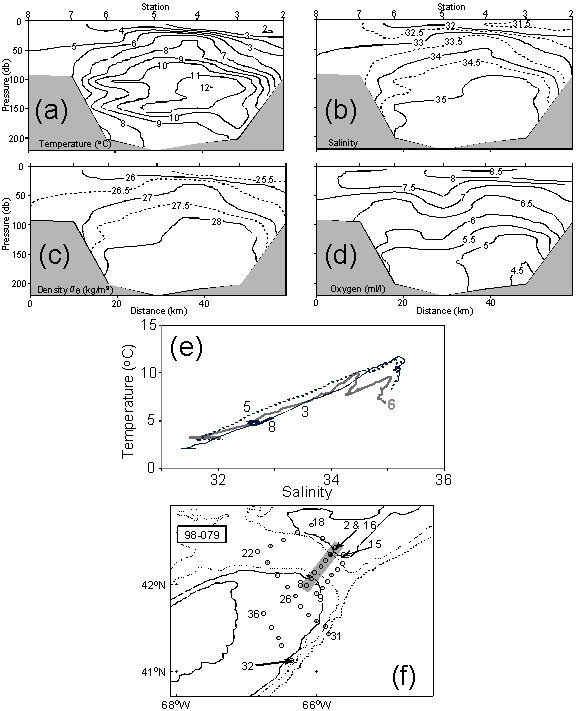
5c. Sections
CTD sections Ia,b, II, III,
IV, and V (Figs. 3-8) depict hydrographic conditions, 1) across the sill in
Northeast Channel, 2) across Northeast Channel roughly 10 km seaward of the
sill, 3) along the western edge of Browns Bank, 4) across the western flank of
Browns to the centre of Georges Basin, 5) across the eastern tip of Georges
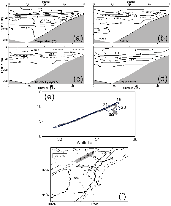
Bank, and 6) across the southeast flank of Georges, respectively. Section Ia (Fig.3) shows Warm Slope Water (WSW;
T~15oC, S~35.5) concentrated on the eastern side of Northeast
Channel at depth (>100 m), with an associated oxygen minimum. At the surface, a thin layer (10-20m) of
cold fresh (T<4oC, S<32) Scotian Shelf water stretches across
the Channel to CTD6 on the western side.
The T-S trace at CTD6 shows interleaving between WSW and an intermediate
water mass from the Gulf.
On Section Ib (Fig.4), the
distribution of high temperatures is much more pervasive than on Ia, both in
the NEC and on Browns Bank. The oxygen
minimum is now below 4 ml/l. The cold
fresh surface layer has virtually disappeared and warm, saline conditions
(10-11oC) prevail at depths near 50m on the eastern side. The minimum surface salinities (~32)
indicate that significant amounts of Scotian Shelf Water is not found in this
part of the NEC, except perhaps at CTD11.
The density section shows that the stratification and baroclinic
pressure gradient are governed primarily by salinity.
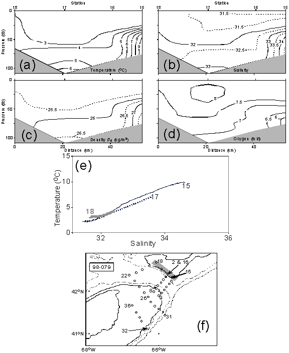
Section II (Fig.5) along the
west flank of Browns Bank shows a thick (~50 m) surface layer of cold Scotian
Shelf Water (T,<4oC, S<32) covering the Bank. Oxygen levels generally exceed 7 ml/l
in this layer. On the offshore side of
the section, the slope water encroaches at depth.
Section III (Fig.6) indicates
that the Warm Slope Water tongue penetrates Georges Basin along the western
flank of Browns, with maximum temperatures and salinities occurring at
CTD19. CTD22 appears to show remnants
of dilluted Labrador Slope Water occurring in the central part of Georges
Basin. The cold fresh surface layer of
SSW covers the section to depths of 30-50 m.
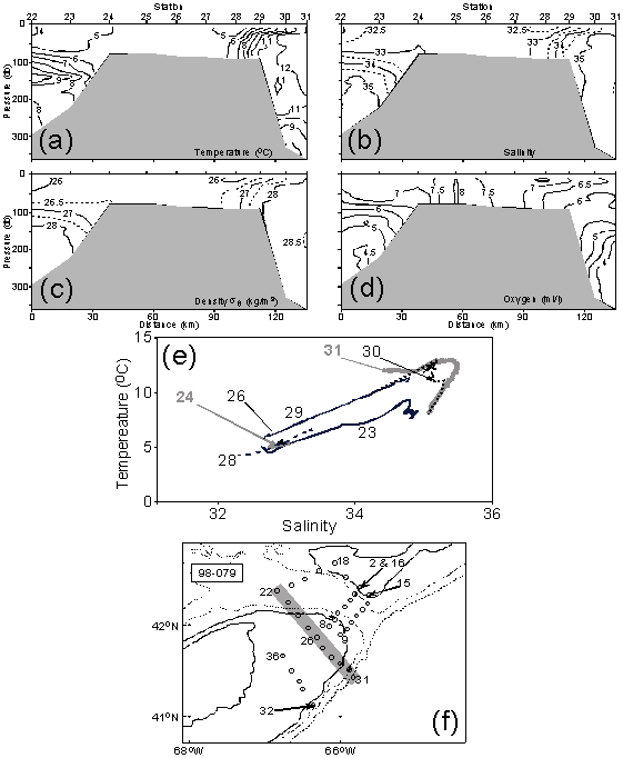
Conditions on Section IV
(Fig.7) show a stark contrast in T,S properties across Georges Bank. On the northern side, the classical Georges
Bank water resides from CTD23-27, while on the southern side, the encroaching
slope water brings higher temperatures and salinities as well as
stratification. The frontal boundary
with the WSW appears to lie near CTD30.
In the surface layers, there is very little evidence of Scotian Shelf
Water, except for a hint in the T,S trace at CTD28 on the southeast flank.
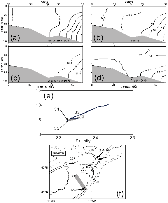
Conditions on Section V
(Fig.8) again show now strong evidence for the influence of SSW, except for
weak minima in temperature and salinity centred at CTD35. Again the foot of the shelf/slope front is
found near the 100 m isobath.
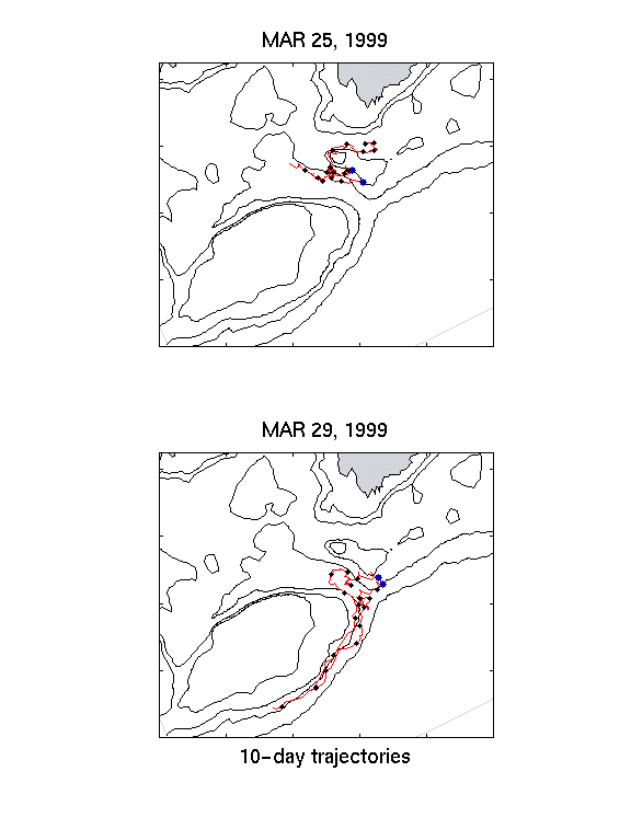
6. DRIFTER DEPLOYMENTS
A complement of two
WOCE-style drifters (spherical surface flotation ball encasing ARGOS
transmitter, holey sock drogue centred at 10 m) were deployed during the mission
(Tables 2 and 4). These were placed on
March 25 after the casts on CTD16 and CTD17, along Section II on the western
side of Browns Bank. Their initial
progress (10-day trajectories) was into the Gulf of Maine, with the inshore
drifter turning anticyclonically around Browns Bank, and the offshore buoy
heading into Georges Basin (Fig.9a).
By contrast, a second pair
of drifters were deployed on the southern flank of the Bank by a Fisheries
Patrol vessel on March 29. These two
buoys crossed Northeast Channel after penetrating some distance into the Gulf,
then exited the region along the southern flank of Georges near the 100 m
isobath (Fig.9b).
No major problems were
encountered during the drifter deployments.
Acknowledgements:
We are greatly indebted to the officers and crew of
the C.C.G.S. Cygnus for their skilled assistance and friendly cooperation,
which was vital to the success of this mission. We also thank Erica Head, Jim Reid and Jeff Anning for their advice
and support with the biological sampling systems.
TABLE 1. Moorings Deployed During Cygnus 98-078, 23-31, 1999
Mooring Site N. Lat. Placement Instrument
No. (Depth,m) W. Long. Time(Z),Date (Depth,m)
Guard NECW 42o07.38’ 1325, Feb.12 SC2325(1)
Buoy “V” (213) 66o01.08’
_________________________________________________________________________________
TABLE 2. CTD Stations During C.C.G.S. Cygnus 98-079,
23-31 March, 1999
|
|
|
|
|
|
|
|
|
Stn. No. |
Latitude |
Longitude |
Sounding |
Yearday |
Date Time(UTC) |
Sampling |
|
|
|
|
(m) |
|
dd/mm/yy hrs |
|
|
0(1) |
44 41.00 N |
63 37.97 W |
54 |
82 |
23/3/99 1258 |
tests |
|
2 |
42 24.95 N |
65 43.87 W |
100 |
83 |
24/3/99 1305 |
|
|
3 |
42 20.11 N |
65 47.97 W |
205 |
|
24/3/99 1337 |
|
|
4 |
42 16.24 N |
65 52.36 W |
228 |
|
24/3/99 1423 |
|
|
5 |
42 11.94 N |
65 56.43 W |
225 |
|
24/3/99 1515 |
|
|
6 |
42 07.61 N |
66 02.15 W |
212 |
|
24/3/99 1613 |
|
|
7 |
42 03.76 N |
66 04.81 W |
97 |
|
24/3/99 1656 |
|
|
8 |
41 59.19 N |
66 08.44 W |
94 |
|
24/3/99 1727 |
|
|
9 |
41 53.58 N |
66 00.03 W |
98 |
|
24/3/99 1837 |
|
|
10 |
41 57.45 N |
65 54.95 W |
116 |
|
24/3/99 1917 |
|
|
11 |
42 02.01 N |
65 51.12 W |
248 |
|
24/3/99 1950 |
|
|
12 |
42 06.18 N |
65 47.22 W |
251 |
|
24/3/99 2032 |
|
|
13 |
42 10.08 N |
65 42.55 W |
279 |
|
24/3/99 2135 |
|
|
14 |
42 14.03 N |
65 38.37 W |
115 |
|
24/3/99 2223 |
|
|
15 |
42 19.87 N |
65 37.30 W |
103 |
|
24/3/99 2303 |
Bot/Bong |
|
16 |
42 24.73N |
65 43.55 W |
100 |
84 |
25/3/99 0050 |
Dr#15234 Bot/Bong |
|
17 |
42 31.01 N |
65 55.47W |
126 |
|
25/3/99 0236 |
Dr#14572 Bot/Bong |
|
18 |
42 40.09 N |
66 04.55 W |
72 |
|
25/3/99 0453 |
Bot/Bong |
|
19 |
42 35.33 N |
66 16.70 W |
168 |
|
25/3/99 0553 |
|
|
20 |
42 30.07 N |
66 28.44 W |
260 |
|
25/3/99 0709 |
|
|
21 |
42 26.08 N |
66 38.95 W |
333 |
|
25/3/99 0820 |
|
|
22 |
42 22.28 N |
66 50.57 W |
341 |
89 |
30/3/99 0800 |
|
|
23 |
42 14.44 N |
66 41.92 W |
251 |
|
30/3/99 0910 |
|
|
24 |
41 05.92 N |
66 33.94 W |
81 |
|
30/3/99 1019 |
Bot/Bong |
|
25 |
41 58.05 N |
66 25.44 W |
85 |
|
30/3/99 1151 |
|
|
26 |
41 51.94 N |
66 18.50 W |
84 |
|
30/3/99 1250 |
Bot/Bong |
|
27 |
41 44.90 N |
66 14.20 W |
89 |
|
30/3/99 1413 |
Bot/Bong |
|
28 |
41 38.84 N |
66 07.11 W |
100 |
|
30/3/99 1525 |
Bot/Bong |
|
29 |
41 34.91 N |
66 00.41 W |
111 |
|
30/3/99 1630 |
Bot/Bong |
|
30 |
41 30.90 N |
65 52.93 W |
713 |
|
30/3/99 1822 |
Ring |
|
31 |
41 25.84 N |
65 49.87 W |
1650 |
|
30/3/99 1908 |
|
|
32 |
41 07.53 N |
66 22.04 W |
144 |
|
30/3/99 2220 |
|
|
33 |
41 17.83 N |
66 29.83 W |
95 |
|
30/3/99 2338 |
|
|
34 |
41 23.07 N |
66 32.87 W |
94 |
90 |
31/3/99 0016 |
|
|
35 |
41 30.14 N |
66 38.92 W |
79 |
|
31/3/99 0105 |
|
|
36 |
41 40.18 N |
66 45.85 W |
71 |
|
31/3/99 0207 |
|
|
37 |
42 16.03 N |
63 19.04 W |
153 |
|
31/3/99 1956 |
Bot/Ring |
|
38 |
44 29.03 N |
63 31.50 W |
44 |
|
31/3/99 2234 |
|
TABLE 2a. Temperature and Salinity Calibration
Results for Cygnus 98-079
QUANTITY NO. SAMPLES MEAN
DIFF. STD. DEV.
CTD vs. Standard
Salinity:
CTD-AutoSal. 25 -0.069 0.059
Flowthru-AutoSal 27 0.77 0.17
Standard vs. Standard
Nutrients:
Sampl.1-Sampl.2. not yet
available
______________________________________________________________________________
TABLE 2b. Surface Dissolved Oxygen Regression Results for Cygnus 98-079
Y = aX (Y=saturation, X=sensor)
SENSOR(CTD) NO. SAMPLES a±da ±dY(ml/l) r2
YSI(230678) 35 1.406±0.008 ±0.24 0.67
TABLE 2c. Surface CTD vs. Flow-Through System for Cygnus 98-079
Y =
aX+b (Y=surface CTD, X=flow-thru
system)
VARIABLE NO. a±da b±db(ml/l) ±dY(ml/l) r2
. SAMPLES
Temperature (oC) 31 1.023±0.010 -0.97±0.05 ±0.09 0.997
Salinity: Phase I 18 1.055±0.133 -3.14±4.46 ±0.30 0.797
(24-25 Mar.)
Phase II 16 0.997±0.046 -0.54±1.54 ±0.15 0.971
(30-31 Mar.)
________________________________________________________________________________
TABLE 3a. Click here.
________________________________________________________________________________
TABLE 3b. Click here.
_______________________________________________________________________________
TABLE 4.
Drifter Deployments during C.C.G.S. Cygnus 98-079
Buoy ID# N. Lat. W. Long. Time(Z),Date
15234 42o24.48’ 65o43.21’ 0131, 25 Mar.
14572 42o34.25’ 65o55.26’ 0321, 25 Mar.