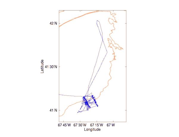
Figure 1. Track for R/V EDWIN LINK Cruise 9906 (EL9906), 14-23 June 1999.
Cruise Report
R/V Edwin Link Cruise EL9906
Woods Hole, MA to Woods Hole, MA
14-23 June 1999
Acknowledgments
Primary reason for any success during this phase of the experiment was the skill of officers and crew who sailed on R/V EDWIN LINK in 1999 and USGS colleagues. Without them the tripods on the array would have been lost and redeployment impossible. In particular, our cruise would have been a scientific disaster and financial catastrophe without the ROV operators, Ben Chiong and Alan Fuller, assisted by Brian Guest. The ROV pilots believed that they would pick up a single tripod that had a failed release. Instead they skillfully recovered the entire array of tripods in conditions of high currents and low visibility, with significant seas for a couple of days. Added to this was the splicing of a cable with fine wires after a break occurred, and the complete re-termination (on an open deck) of the tether to the ROV after both layers of the protective jacket were cut.
Special recognition is given to R/V CONNECTICUT which carried replacement releases from Woods Hole to Georges Bank.
This report was prepared by R. Schlitz with contributions from J. Manning, R. G. Lough, E. Broughton, and R. Gamble.
This research was sponsored by the NOAA Coastal Ocean Office under funding for the U. S. Global Ocean Ecosystem Dynamics Program Northwest Atlantic Field Studies, Phase III.
Table of Contents
1. Purpose of Cruise
2. Cruise Narrative
3. Cruise Results
4. Scientific Personnel on Cruise EL9906
List of Tables
Table 1. Summary of information on the moorings set during EL9906
Table 2. Event log for EL9906
1. Purpose of Cruise
This cruise had two major goals. The first was to recover and reset a closely-spaced array of moorings at seven sites centered at the 60 m isobath on southern Georges Bank. The array was situated approximately perpendicular to the local topography spanning the historical location of the tidally mixed front. (See cruise track, Figure 1)
Figure 1.
Track for R/V EDWIN LINK Cruise 9906 (EL9906), 14-23 June 1999.
The second goal was to examine the abundance, distribution, and condition of ichthyoplankton, specifically cod and haddock, along the array in relation to the hydrographic structure. EL9906 was the second in a series of three cruises, following OC339 in March 1999. The overall GLOBEC goal is to focus on the physical processes that determine the circulation within the regime of the tidally mixed front on southern Georges Bank and associated dynamics of plankton.
2. Cruise Narrative
We departed Woods Hole at 09:30 EDT on Monday, 14 June 1999 and steamed through Nantucket Sound toward Great Round Shoal on the way to the moored array. At 12:30 EDT there was a safety drill and at 19:00 a meeting at the request of the Master about the mooring work. The winds and seas were moderate and fog was present, sometime heavy and sometime not. The estimated time of arrival at Site 1 was about 00:30 EDT on 15 June at which time an ADCP section was run from Site 1 to Site 7, then a CTD section run back so that we would be back at Site 1 at 05:00 EDT to begin recovering the unprotected tripods. There were problems with both shipboard ADCP units.
At 05:00 EDT on Tuesday, 15 June 1999 we were at Site 1 for recovery. The weather was foggy, with slight seas and moderate swells. The transducer was placed in the water and communication was established with the release on the tripod. The command to release was sent a number of times with a response that it did not release. A short search at the area was conducted, then we went on to Site 3 to try the tripod there. At ~07:50 EDT we released the floats on the tripod at Site 3. The release was confirmed, and a search did not find the balls at the surface. At 09:00 EDT we departed for Site 5 to release the next tripod. There was an unknown signal that was interfering with the ability of the deck gear to talk with the release. The floats were released but again they were not seen on the surface. We arrived at Site 7 about 11:00 EDT to release tripod. Before doing it the ship did tight turns to find the tripod and balls on the “fishfinder” and determine attitude of the tripod if possible. This would be done again if balls did not come to surface to see if they could be detected in the water column. The release was triggered at Site 7 but no balls were seen. We returned to Site 3 at the time of minimum current toward the east (slack water) to see if balls were at the surface. Nothing was seen except R/V OCEANUS as rain started. At about 13:30 EDT rigging started for ROV operations. The ROV was successful in placing a line on the the tripod and it was recovered during the afternoon. The release did not work as designed, pulling the pin. One problem was with the flotation and the stainless steel rod. The flotation balls, over time, bent the stainless rod upward so that it was no longer in the u-shaped holders. This placed a torque on the attachment bar and ring that was in the release. There was enough friction caused by the torque so that the flotation was bound. On the next ROV rescue mission, the first action would be to try to jar the line loose. A solution was needed for the flotation before setting the instruments again. At ~17:30 EDT the mooring operations were done for the day. There would be a series of MOCNESS hauls at the 60 m isobath accompanied by short CTD/nutrient sections to define the local environment. There was a short power failure at ~18:30 that appeared to have done no damage to our equipment. MOCNESS tows, 3, and two short CTD sections overnight caught larvae across the tidal front
On Wednesday, 16 June 1999 we moved to Site 5 so that the ROV could help in recovering the tripod at this site. The release reported that it had released as had the tripod at Site 3. We performed an acoustic triangulation before ROV launch. The ROV was launched to get the tripod in less than ideal conditions with high current. With much skillful piloting the recovery line was attached. After the ROV was at the surface and on board, a line was seen wrapped around one of the thrusters. It was under tension and could not be released so it was cut. Soon thereafter the balls were seen at the surface astern on the boat. They were riding well in the current, so suspicion that the balls could be underwater after release was not substantiated. The tripod was recovered intact with some growth but not an unusual amount. At Site 7 there was no ranging due to dead batteries and the release command did not bring the balls to the surface. This was one of the sites that has noise in the water from an unknown source that did not allow communication with the release previously. The ROV launch was planned to coincide with low current after 13:00 EDT. The tripod was difficult to find at Site 7 but was finally seen. Then it was detected that the line for recovery was again wrapped around a thruster so the ROV was brought back on board to clear the thruster. At the same time we were told that the tripod legs were buried. Since the release transducer would be closer to the bottom another attempt to release the balls was made at high power before sending the ROV back into the water. Each tripod located by the ROV to date was is about 110 ft (~33.5 m) from the launch position, perhaps caused by caused by antenna location for the GPS receiver at launch. The tripod at Site 7 was recovered using the ROV without incident during the afternoon. At 17:18 EDT the surface marker at new Site 7 (J) was set easily. The position was 41° 00.40' N 67° 22.82' W in 68 m of water. The tripod was then set nearby at 41° 00.43' N 67° 22.90' W in 68 m of water at 17:54 EDT. The night watch was to continue with a series of MOCNESS hauls at the 60 m isobath and short CTD sections across the bank. The Broadband shipboard ADCP was back with the heading problem possibly resolved. Narrow band ADCP will not be functional since there was probably a chip failure in the deck box.
It is Thursday, 17 June 1999. Three MOCNESS hauls and two CTD sections were done overnight. Heading input to the ADCP failed early in the watch. At the end of the watch testing was done on the Broadband ADCP to see if there was any relation between speed and heading. None was found. There was contact with R/V OCEANUS to see if they had a spare synchro card for either unit. Mooring work was to begin the day by placing surface markers at new Sites 5, 3 , and 1. Then the ROV would be used at “slack” current at original Site 1 on the tripod. Winds and seas were higher from the N and NE. A surface marker was set the at new Site 5 (D) at 08:39 EDT in 63 m of water. The position was 41° 03.95' N 67° 23.99' W. The next was Site 3. We started setting surface marker at Site 3 (B). After the float was over the stern and one shot of chain was released it had to be brought alongside again since the black plastic bag covering the light was left on the marker. After removal, the buoy was set at new Site 3 (B) at 10:13 EDT in 59 m of water. The position was 41° 05.91' N 67° 24.99' W. The surface marker at new Site 1 was set without incident at 11:24 EDT in 67 m of water. The position was 41° 08.79' N 67° 26.54' W. Next operation was the recovery of the tripod at Site 1 with the ROV. We began as Site 1 after lunch, as the tidal current moved toward the east. After consulting with R/V OCEANUS, RDI, and the onboard technicians a rendezvous with R/V OCEANUS was planned to get a circuit board that may get the narrow band ADCP functioning. The Master would contact them after the ROV is completed. We learned that all the ADCPs for the first setting were recorded in earth coordinates rather than beam coordinates due to an error in setting up the instruments. The second setting would be in beam coordinates. However, the magnetic declination was not included so the records were now magnetic earth coordinates when recorded. The ROV hooked the tripod at Site 1 but the hook straightened out when tension came on the line and the tripod remained in place. The situation with the releases was grim at the moment. Calls were made to USGS in Woods Hole to see if old releases at USGS could get to the ship in some way so that the tripods could be put back in. The ROV captured the tripod at Site 1 and it was brought on board at 16:55 EDT. After the deck was secured we headed toward the position where R/V Oceanus would be located. Paige Valentine from USGS was coming to Georges Bank on R/V CONNECTICUT and was willing to bring the releases and associated hardware. At ~19:15 EDT the small boat was launched in less than ideal conditions to get the circuit board from R/V OCEANUS.
The new board was placed in the narrow band ADCP and appeared to have cured the problem. Now the conditions were rough enough to be marginal. Only a CTD section with nutrients was completed along the new mooring line designated as Site 11 etc., overnight. This morning, Friday, 18 June 1999, a tripod would be set at Site 11 then recoveries continued. The tripod at Site 11 was set after the release mechanism was tested successfully on the tripod. It was set at 09:06 EDT at 41° 08.83' N 67° 26.54' W in 57 m of water. We headed to Site 2 for recovery of the subsurface mooring and ROV operation on the tripod that never responded on OC339. The subsurface mooring at Site 2 was recovered, but with some difficulty due to the seas. The pickup could not be made into the eye with a pole, so the grapnel was used. The ROV crew needed to fix a cable-break before the ROV could be used again. At Site 2 the surface marker A was recovered. All temperatures from 11 Minilogs (10 t and 1 t/p) were downloaded and looked good. We headed to Site 4 for the subsurface float while the ROV cable repair potting continued to cure. The subsurface mooring at Site 4 was recovered. There was some confusion about the Minilogs that was being resolved. We heading back to Site 2 for a ROV recovery. The ROV had trouble finding the tripod after a couple of hours of search. The Minilogs at Site 4 were downloaded. All worked fine except one had a communication problem, the pressure sensor drifted near the beginning of the record (there was an offset at the end), and one was short because it was borrowed and had less memory. The tripod at Site 4 came on board 19:30 EDT. A MOCNESS at station 100 was planned then at ~23:00 EDT, we needed to leave and meet R/V CONNECTICUT, not in Great South Channel as previously believed but on the northern edge of Georges Bank. Here the transfer of releases and modification equipment for tripods would occur. ROV ~$250,000 and not yet done.
Early on Saturday, 19 June 1999 we steamed toward the Northern Edge to meet R/V CONNECTICUT. The transfer of four releases and associated gear took place by small boat at ~07:00 EDT and we started back toward the mooring line for more recovery. We were headed to Site 2 when the ROV crew noticed that their tether was cut and they would not be able to use the ROV further. Since the weather was good and the forecast was good they would try to re-terminate but the ROV would be out of commission for at least 12 hours. Based on the potential loss of Sites if the remaining two releases failed and the ROV could not be used again, we would immediately move to Site 4, at the 60 m isobath. A surface marker at Site 41 was launched in 60 m of water at 12:59 EDT. The position was 41° 04.95' N 67° 24.56' W. The next operation was a sub-surface mooring at Site 41. The sub-surface mooring was launched at 15:10 EDT in 60 m of water. The position was 41° 04.86' N 67° 24.51' W. The release was interrogated and replied. The final operation at Site 41 was to launch the tripod. The tripod was launched at 16:55 EDT in 60 m of water also. The position was 41° 04.98' N 67° 24.51' W. The release used was one of the Edgetech shallow water releases that functioned properly on the first deployment. Then we has a surprise as two of the new releases transferred from the R/V CONNECTICUT did not check out. The result was that we were now down one tripod for the new line. The sub-surface mooring at Site 6 was next. When the release was fired only two balls were seen at the surface. Also the location where they surfaced was very close to the surface marker. When recovered, ~19:59 EDT, the top sub-surface ball was missing and the top shot of wire was wrapped around the remainder of the mooring but stripped clean of the insulation. A number of Minilogs were lost. This appeared to be damage from trawling although the position was well inside the Closed Area. An attempt was made to talk with the tripod here. It was successful, reporting upright. We then went to the tripod at Site 4 to check the release. It also was successful. Now (20:00 EDT) and until the ROV pilots finish on deck, we are steaming an ADCP line along the new array at 4-5 kts in order to avoid any cavitation. The ROV folks said at 21:00 EDT that they have completed repairs electrically with the ROV and just need to complete a couple of things tomorrow.
Overnight here were three MOCNESS hauls at station 100 and two ADCP transects along the new line. On Sunday, 20 June 1999 in the morning we were at Site 31 to launch a tripod. Preparations were proceeding slowly. The tripod was launched at 08:31 EDT in 59 m of water. The position was 41° 05.89' N 67° 25.01' W. We proceeded to Site 51 for launch of the tripod. On the way a line was seen submerged and the ship returned to investigate and nothing found then. The tripod at Site 51 was launched without incident at 09:23 EDT in 61 m of water. The position was 41° 03.87' N 67° 24.09' W. At 11:30 EDT we completed a MOCNESS tow and headed for old mooring line to recover the two remaining surface floats and tripods. The ROV was to be ready at that time. We recovered surface marker at Site 4 (L) after some problems with maneuvering. The release on the tripod at this site was turned on, ranged, and released. There was confirmation but the balls did not come to the surface. We left Site 4 to reset the surface buoy at Site 21 then return to Site 4 for the ROV work. On the way over to the location, there was a report that the drifter set by R/V OCEANUS was seen. We planned pick it up, as requested, on the way back. The surface marker at Site 21 was set at 14:41 EDT in 58 m of water. There was confused communication with the bridge so the anchor was dropped off station by a bit, but not serious problem. The position was 41° 07.20' N 67° 25.75' W. We then moved back to Site 4 for ROV recovery of the tripod since the balls did not come to the surface in the interim. The drifter was not seen even though a waypoint was set for the location. Also there was not a VHF radio transmission received on R/V EDWIN LINK from the drifter. The ROV was sent after the tripod at site 4. Within about 30 min. the balls were released by the ROV resulting from giving a couple of jolts to the tripod. The balls came up about 50 m on the port beam and the tripod recovered without incident. The tripod however was not in good shape. There was rust visible everywhere and corrosion was seen to the level that the tripod was replaced before another setting. There was no obvious reason for this deterioration. At 17:00 EDT the marine forecast for Georges Bank on Monday night was such that the surface buoy at Site 6 would be recovered and the ROV would go after the tripod on this evening. The surface buoy at Site 6 was recovered without too much problem at 18:00 EDT. However the boot at the top end of the jacketed wire was cracked and the wire rope near the top was stripped. Following recovery the deck was cleared. After triangulation of the release, the ROV went after the tripod. Although the release would talk nicely, there was no confirmation that it had released after the command was sent. Even though the ship was held in position over the tripod (the return from the tripod was on the sonar display for long periods of time with strong returns) the ROV had some difficulty locating the tripod. When it was finally hooked the tripod was recovered without incident at about 21:30 EDT. The rest of the night would be for MOCNESS tows then CTD/nutrient sections along the new mooring line.
There was an ADCP section at the end of the night watch early on Monday, 21 June 1999. The first work today would be setting the surface marker at Site 61. We did an ADCP section toward the south to Site 71 then returned to set the buoy. The light at Site 2 was extinguished. We planned later to go over with the small boat to tie on an “emergency” light. Also unless a call to Edge Tech resolved the problems with the new releases, there would not be one for the seventh tripod. The surface buoy at Site 61 was set at 08:12 EDT in 63 m of water. The position was 41° 02.68' N 67° 23.35' W. We headed to Site 21 to send the small boat over to place a small self-contained light on the buoy. If we remained one release short, the preference was to put a tripod back in rather than the temperature string on a subsurface mooring. The light was attached to the buoy at Site 2 at ~09:20 EDT. The sub-surface mooring at Site 21 was set at 11:48 EDT in 58 m of water. The position was 41° 07.24' N 67° 25.73' W. While the releases tested there would be a MOCNESS at station 100 starting about 12:30 EDT. We determined that we could set everything by using the release that drops the tripods on the last sub-surface mooring. The tripod at Site 21 was set at 15:55 EDT in 58 m of water. The position was 41° 07.17' N 67° 25.80' W. This was done without problem. We steamed for Site 61 to set the tripod and sub-surface float. There was some delay while the instruments were prepared for placing on the tripod. Also a hydraulic coupling on the ROV winch blew spraying some oil causing a slight further delay. The tripod at Site 61 was set at 17:38 EDT in 64 m of water. The position was 41° 02.60' N 67° 23.41' W. The night was scheduled for MOCNESS, ADCP, MOCNESS, and CTD/nut section. The intention was to be in position for a MOCNESS at 06:30 EDT in the morning. There was a call from R/V ENDEAVOUR about the possibility of transferring some people to return them to Woods Hole. They would be back in touch tomorrow. The ETA was set at 12:00 EDT on Wednesday.
Overnight there was an ADCP section with sampling at 1 min rather than 5 min averages to try to get finer resolution, MOCNESS, CTD/nut section, MOCNESS, and ADCP section. At 06:30 EDT on Tuesday, 22 June 1999 we were at station 100 for a MOCNESS haul. The Mate reported that during the night watch the light was extinguished at Site 2. The best guess was that the battery was not able to charge under the sky conditions yesterday. We would investigate after lunch. The Master talked with R/V ENDEAVOUR about the transfer of personnel to R/V EDWIN LINK for return to Woods Hole. The people were trying to rebuild an instrument and would call at noon. It sounded like a MOCNESS 10 was lost or damaged, but nothing was certain in the conversation. The final sub-surface mooring was set at Site 61 in 64 m of water at 09:57 EDT without incident. The position was 41° 02.67' N 67° 23.29' W. We then headed back to station 100 for a MOCNESS haul. After the completed MOCNESS haul we steamed to Site 21 and set over the small boat to check the light. When the lamp was covered the light came on. The battery just needed charging through the solar panel. After the small boat was recovered and secured we steamed to Site 11 and started an ADCP line toward Site 71 at ~7 kt due to the good sea conditions. The line started at about 13:15 EDT. We would meet R/V ENDEAVOUR on the way home at about midnight and transfer three people who would be coming back to Woods Hole with us. The ADCP line ended at 14:40 EDT. We then steamed to station 100 for a MOCNESS tow that started around 15:30 EDT. We received a message from Bob Groman in the GLOBEC office indicating that the file with all array positions was received and would be distributed. The MOCNESS tow ended at about 16:30 EDT. The next and last tow would be at 19:30 EDT before heading home. A final ADCP section is being taken from north to south along the array. There could have been a problem near the beginning with navigation since the GPS receiver was changed on the bridge. The final MOCNESS haul at station 100 began at about 19:00 EDT. At end of MOCNESS haul, scientific sampling ended for this cruise. We headed toward Woods Hole via Great Round Shoal with the intention of meeting R/V ENDEAVOUR on the way and transferring three people.
The pick up added a fourth person from R/V ENDEAVOUR. We steamed for Woods Hole with ETA at noon on Wednesday, 23 June 1999. All were relieved and very appreciative that the presence of talented ROV operators and shipboard personnel averted a major disaster for the experimental program.
3. Cruise Results
There were two primary goals for EL9906. The first was to recover and reset a closely-spaced linear array of seven moorings centered at 60 m (Figure 2) in order to examine the circulation and hydrography, thermal structure in particular, at the tidally mixed front on the southern flank of Georges Bank.
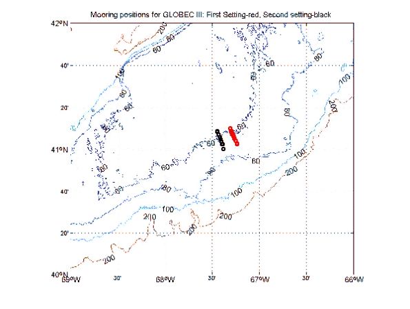
Figure 2.
Moored array recovered and reset during EL9906. The positions for the array
recovered are in red. The second setting of the array is in black:
A. The setting of the arrays in
relation to the regional bathymetry for Georges Bank.
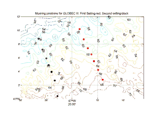
Figure 2. Moored array recovered and
reset during EL9906. The positions for the
array recovered are in red. The second setting of the array is in black:
B. The arrays in relation to the
detailed bathymetry along the southern flank. These moorings are
designated Sites 1-7 from North to South with particulars about the
second setting presented in Table 1
This was successful but extremely difficult as seen from the cruise narrative above. The second setting was moved toward the west due to the unplanned and rather sudden opening of Closed Area II for scalloping. The designated area was scheduled to remain closed for the duration of the experiment, March-August 1999. At each location a tripod was placed on the bottom with an upward-looking ADCP (Figure 3) that resolved the currents within the water column at 1 m intervals and temperature, salinity, and pressure recorders.
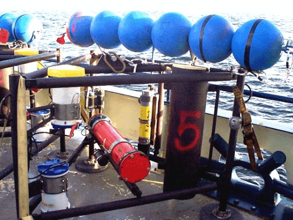
Figure 3. A tripod for the
array recovered and reset at Sites 1-7 during EL9906.
Also surface and sub-surface moorings were placed at Sites 2, 4, and 6 to provide temperature records throughout the water column. Data for the moorings in the array during the second setting on the southern flank of Georges Bank are summarized in Table 1.
Table 1. Summary of information on the moorings set during EL9906. This is an array to study physical processes at the tidally mixed front on the southern flank of Georges Bank.
| Site number | Latitude N | Longitude W | Depth (m) | Time (Z) | Date |
|---|---|---|---|---|---|
| 11 surface (E) | 41 08.79 | 67 26.54 | 57 | 1524 | 17 June |
| 11 tripod | 41 08.83 | 67 26.54 | 57 | 1306 | 18 June |
| 21 surface (L) | 41 07.20 | 67 25.75 | 58 | 1841 | 20 June |
| 21 sub-surface | 41 07.24 | 67 25.73 | 58 | 1548 | 21 June |
| 21 tripod | 41 07.17 | 67 25.80 | 58 | 1955 | 21 June |
| 31 surface (B) | 41 05.91 | 67 24.99 | 59 | 1423 | 17 June |
| 31 tripod | 41 05.89 | 67 25.01 | 59 | 1231 | 20 June |
| 41 surface (A) | 41 04.95 | 67 24.56 | 60 | 1659 | 19 June |
| 41 sub-surface | 41 04.86 | 67 24.59 | 60 | 1910 | 19 June |
| 41 tripod | 41 04.98 | 67 24.51 | 60 | 2055 | 19 June |
| 51 surface (D) | 41 03.95 | 67 23.99 | 63 | 1239 | 17 June |
| 51 tripod | 41 03.87 | 67 24.09 | 61 | 1323 | 20 June |
| 61 surface (F) | 41 02.68 | 67 23.35 | 63 | 1212 | 21 June |
| 61 sub-surface | 41 02.67 | 67 23.29 | 64 | 1357 | 22 June |
| 61 tripod | 41 02.60 | 67 23.41 | 64 | 2138 | 21 June |
| 71 surface (J) | 41 00.40 | 67 22.82 | 68 | 2118 | 16 June |
| 71 tripod | 41 00.43 | 67 22.90 | 68 | 2154 | 16 June |
The second goal was the physical and biological characterization across the southern flank of Georges Bank emphasizing the area near the tidally mixed front. This was done through a series of CTD sections and MOCNESS hauls.
A number of temperature and salinity sections, including nutrients to be analyzed by D. Townsend, were completed along the moored array. The positions are shown in Figure 4.
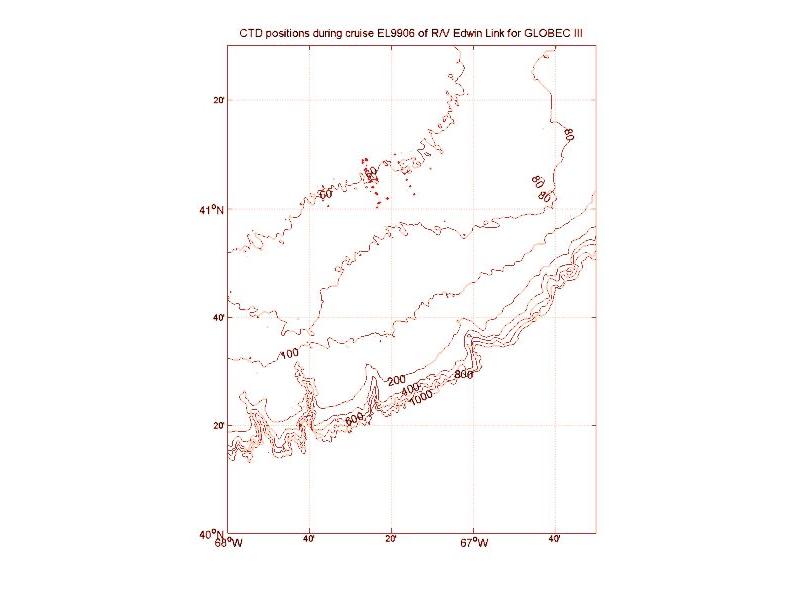
Figure 4. Positions for CTD casts
completed during EL9906: A. Stations
in relation to the bathymetry on the southern flank of Georges Bank.
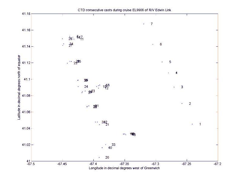
Figure 4. Positions for CTD casts
completed during EL9906: B. Station
positions and numbers for CTD casts.
The first section along the first setting of the array, stations 1-7, showed the early development of the seasonal thermocline near a depth of 10 m (Figure 5). Clearly temperature controlled the density structure in the vicinity of the tidally mixed front.
Figure 5. CTD section for stations 1-7
during EL9906, 14-23 June 1999. The stars represent the
positions of the Sites 1-7 for the moored array as presented in Table 1:
A. Temperature in °C.
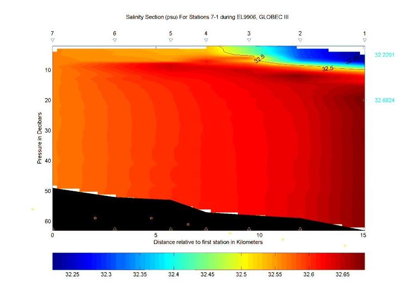
Figure 5. CTD section for stations 1-7
during EL9906, 14-23 June 1999. The stars represent the
positions of the Sites 1-7 for the moored array as presented in Table 1:
B. Salinity in psu.
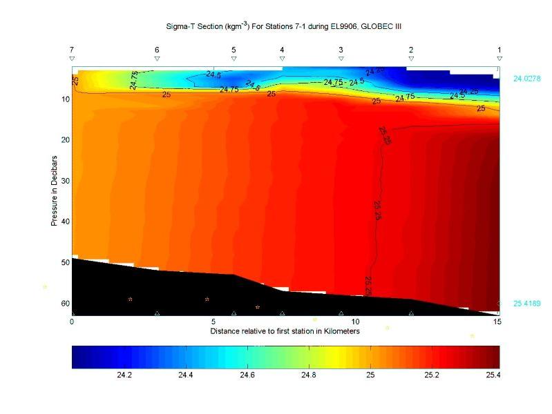
Figure 5. CTD section for stations 1-7
during EL9906, 14-23 June 1999. The stars represent the
positions of the Sites 1-7 for the moored array as presented in Table 1:
C. Sigma-T in kgm-3.
The second section, stations 20-26, along the second setting of the array generally reflects the first with the thermocline between 10-15 m capping the cooler water (Figures 6). Also the offshelf gradient in temperature below the thermocline is clear.
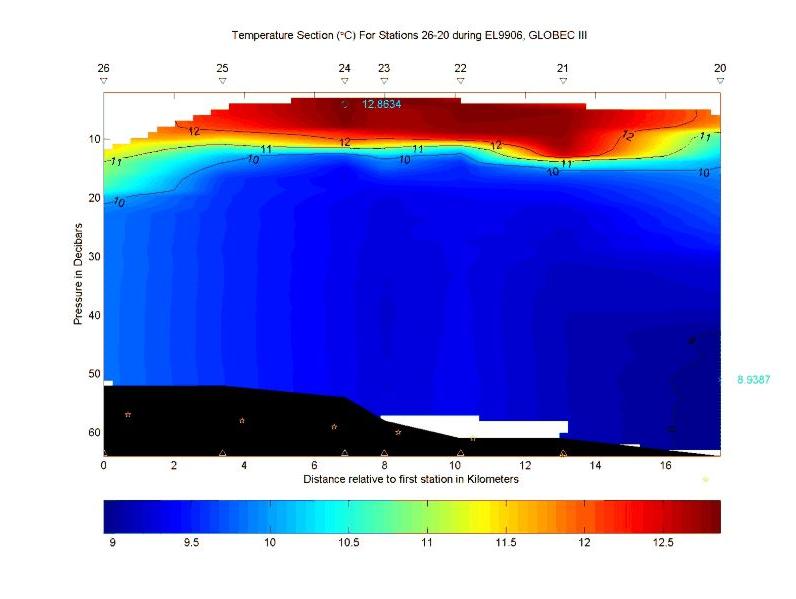
Figure 6. CTD section for stations
20-26 during EL9906, 14-23 June 1999. The stars represent
the positions of the Sites 1-7 for the moored array as presented in Table 1:
A. Temperature in °C.
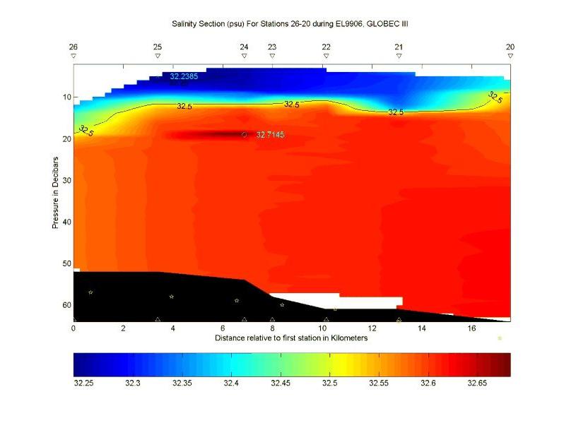
Figure 6. CTD section for stations
20-26 during EL9906, 14-23 June 1999. The stars represent
the positions of the Sites 1-7 for the moored array as presented in Table 1:
B. Salinity in psu.
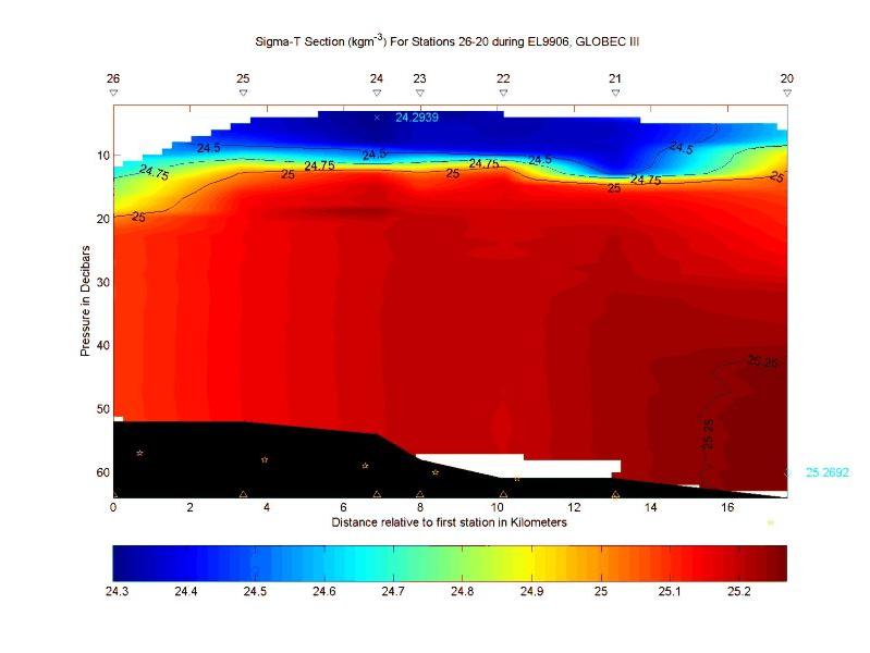
Figure 6. CTD section for stations
20-26 during EL9906, 14-23 June 1999. The stars represent
the positions of the Sites 1-7 for the moored array as presented in Table 1:
C. Sigma-T in kgm-3.
Both the third and fourth sections (Figure 7 and Figure 8) along the second setting show the tidally mixed front near Site 4. Isothermal and isopycnal surfaces begin to spread at the thermocline as the water column transforms from a two layer system to a one layer structure moving onbank. These hydrographic structures were used to initialize a two-dimensional primitive-equation numerical model that was being developed and tested during the cruise.
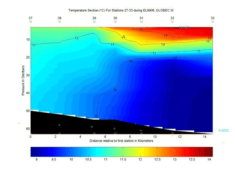
Figure 7. CTD section for stations
27-33 during EL9906, 14-23 June 1999. The stars represent
the positions of the Sites 1-7 for the moored array as presented in Table 1:
A. Temperature in °C.
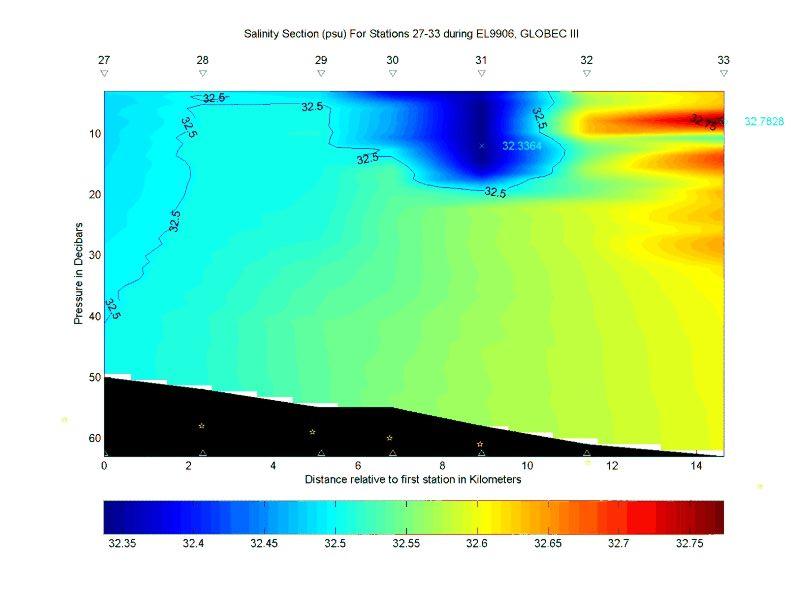
Figure 7. CTD section for stations
27-33 during EL9906, 14-23 June 1999. The stars represent
the positions of the Sites 1-7 for the moored array as presented in Table 1:
B. Salinity in psu.
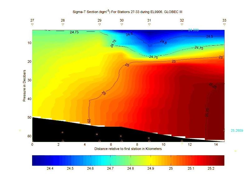
Figure 7. CTD section for stations
27-33 during EL9906, 14-23 June 1999. The stars represent
the positions of the Sites 1-7 for the moored array as presented in Table 1:
C. Sigma-T in kgm-3.
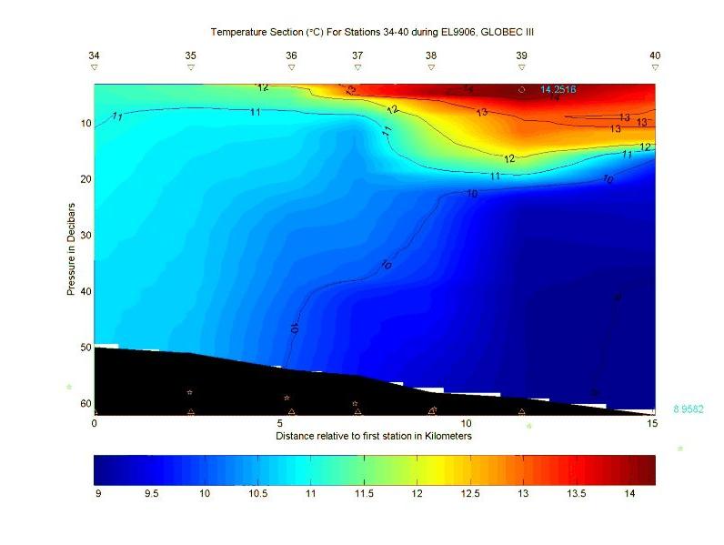
Figure 8. CTD section for stations
34-40 during EL9906, 14-23 June 1999. The stars represent
the positions of the Sites 1-7 for the moored array as presented in Table 1:
A. Temperature in °C.
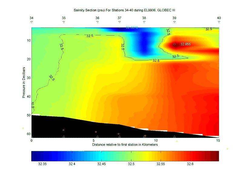
Figure 8. CTD section for stations
34-40 during EL9906, 14-23 June 1999. The stars represent
the positions of the Sites 1-7 for the moored array as presented in Table 1:
B. Salinity in psu.
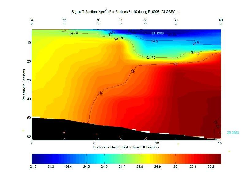
Figure 8. CTD section for stations
34-40 during EL9906, 14-23 June 1999. The stars represent
the positions of the Sites 1-7 for the moored array as presented in Table 1:
C. Sigma-T in kgm-3.
Ichthyoplankton-zooplankton studies during the cruise were managed and reported by R. G. Lough. Cruise Report R/V EDWIN LINK 9906. The 1-m2 MOCNESS with nine 0.333-mm mesh nets was used to sample larval fish and larger zooplankton. Sensors included light and fluoresence; the transmissometer was not working. A video Plankton Recorder (VPR) also was attached to the MOCNESS frame to record fine-scale zooplantkton during the tow. This particular system was held in four underwater housings and consisted of two Hi-8 Video Camcorder interfaced with Tattletale Computer Software, a low (5.6x) and a high (72x) magnification cameras synchronized at 60 Hz with a xenon strobe, a Horita time-code generator and a 24V-8amp Gel battery pack. Operation was independent of MOCNESS. Recordings were downloaded to SVHS tape format. No image processing was done in real-time. Tow profile was nominally 10-m strata within 5 m of the bottom; extra nets were used for special collections. The 1-m2 MOCNESS nets typically sampled for 5 minutes to filter about 250 m3 of water. Extra double-oblique net profiles from the 1-m2 MOCNESS of the entire water column were picked for larval cod and haddock. Samples were frozen in liquid nitrogen for biochemical analysis or preserved in alcohol for otolith analysis. Prior to freezing, larval fish were video taped with a Zeiss Stemi SV6 stereomicroscope rigged with an MTI CCD72 black and white video camera. Other larvae were measured to the nearest 0.01 mm SL using Optimas image analysis software connected to a Zeiss Stemi SV6 stereomicroscope, with a Hitachi HV-C20 color video camera.
The center of the tidal front was located at the 60-m isobath as in May (EL9905), so we continued to sample on former station 100 (41 5.5, 67 23.5), attempting to catch the tide in all its phases. A total of 19 1-m2 MOCNESS tows were successfully made at this station, mostly between 0630 and 1830 h, since mooring operations were conducted during daylight hours. Tows were made during all phases of the tidal cycle, but only 8 tows were made during night because of the long day-light hours. Good VPR recordings were made on all MOCNESS tows, except for the first three tows (294-296) when only the low-magnification camera was working. All MOCNESS tows were conducted in the same manner sampling from 55m to surface with nets 1-6 and then using net 7 to collect plankton from surface to 20m, and net 8 to sample from 20-50m. Nets 7 and 8 were picked for gadid larvae, but very few were collected by the 1-m MOCNESS. Only two cod and 20-30 haddock larvae were frozen for biochemistry. Their were numerous flounder larvae in the samples from recently-hatched to pelagic juveniles. Most abundant plankton was the copepod Temora longicornis, Sagitta elegans, crab larvae, and ctenophores.
4. Scientific Personnel on Cruise EL9906
| Name | Title | Affiliation |
|---|---|---|
| Ronald Schlitz | Chief Scientist | NOAA/NMFS/NEFSC, Woods Hole, MA |
| R. Gregory Lough | Oceanographer | NOAA/NMFS/NEFSC, Woods Hole, MA |
| James Manning | Oceanographer | NOAA/NMFS/NEFSC, Woods Hole, MA |
| Elisabeth Broughton | Biological Technician | NOAA/NMFS/NEFSC, Woods Hole, MA |
| Antonie Chute | Biological Technician | NOAA/NMFS/NEFSC, Woods Hole, MA |
| Marie Kiladis | Biological Technician | NOAA/NMFS/NEFSC, Woods Hole, MA |
| Bruce Burns | Biological Technician | NOAA/NMFS/NEFSC, Woods Hole, MA |
| Ian Heavers | Summer Student | NOAA/NMFS/NEFSC Narragansett, RI |
| Changsheng Chen | Assistant Professor | U. of Georgia, Athens, GA |
| Malinda Sutor | Biological Technician | University of Rhode Island, Kingston, RI |
| Jennifer Skelly | Student | University of Rhode Island, Kingston, RI |
| Keston Smith | Oceanographic | Technician PTSI, Norfolk, VA |
| Marinna Martini | Ocean Engineer | USGS Field Center, Woods Hole, MA |
| Jessica Cote | Ocean Engineer | USGS Field Center, Woods Hole, MA |
| Jonathan Borden | Electronic Technician | USGS Field Center, Woods Hole, MA |
| Jason Hyatt | Oceanographer | USGS Field Center, Woods Hole, MA |
| Brian Guest | Engineering Assistant | WHOI, Woods Hole, MA |
| Katheryn Privett | Biologist | Florida Dept. of Natural Resources |
| Paul Gaynor | Student | Boston University, Boston, MA |
Table 2. Event log for EL9906