This report was prepared by Cabell Davis and Carin Ashjian. This cruise was sponsored by the National Science Foundation.
1. Introduction
1.2 Cruise Overview
3. Results
3.1 Video Plankton Recorder Survey
3.2 Drifter movements and Initial Tracks
3.4 Underway data
4.0 Conclusions
Appendix II - Event Log
1. Introduction
1.1 Purpose of Cruise
The goal of the U.S. GLOBEC program is to understand how biological and physical processes interact to control the abundance and production of marine animal populations. It is recognized that important controls of population abundance of these organisms are rooted in the early life stages which are generally planktonic.
The U.S. GLOBEC Georges Bank program is focusing on the biological and physical mechanisms regulating the abundance of cod and haddock larvae and the dominant zooplankton species, Calanus finmarchicus, and Pseudocalanus spp. upon which they feed. The program includes a combination of field sampling/data analysis and modeling.
The field sampling includes broadscale sampling (conducted monthly from January to June each year) to quantify the population abundance and distribution over the bank and process studies (every other year) which focus on specific dominant physical processes affecting abundance on the bank as well as traditional life history rate measurements. In 1995, the dominant physical process studied was the development of vernal stratification and its effect on growth and survival of the target species. In 1997, the dominant physical process being studied is the transport of plankton onto and off of the bank (i.e. immigration and emigration) by ocean currents.
As part of this effort, the purpose of this cruise was to use the Video Plankton Recorder (VPR) together with ship's hull-mounted Acoustic Doppler Current Profiler (ADCP) to quantify the flux of the copepods Calanus finmarchicus and Pseudocalanus spp. across the northern edge of Georges Bank during January. A ten-year data set from the MARMAP program reveals a strong gradient in Calanus finmarchicus across the northern edge of the bank in fall and winter and GLOBEC Georges Bank circulation models and ARGOS drifters have shown that surface particles have a net movement onto the bank across the northern edge in winter. This potential influx of Calanus across the northern edge during winter is hypothesized to be the major source of these copepods to the bank. This influx is thought to provide seed populations of Calanus which subsequently undergo in situ (on-bank) growth giving rise to their large spring population.
The flux of copepods across the edge of the bank can be
determined from their concentration and the current magnitude and
direction. The VPR serves as a tool for measuring the
concentrations of plankton and other variables (temperature,
conductivity, fluorescence, beam attenuation, and incident light)
with high along-path resolution (cm to 100s of kilometers). The
sampling rate is currently at 60 Hz for video and 3-6 Hz for the
ancillary data. The product of these concentration measurements and
the on-bank water flow yields an estimate of the influx of the
copepods to the bank.
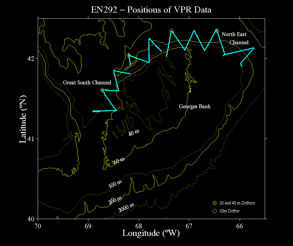
1.2 Cruise Overview
During the cruise, to measure the copepod concentrations and
water flow across the northern edge of the bank, we conducted
sampling in a zig-zag pattern along the northern edge from the Great
South Channel to the west to the Northeast Channel to the east
(Fig. 1).
Despite severe weather which delayed our departure for a few
days and interrupted our at-sea sampling, and despite equipment
problems, we were able to map the entire northern edge of the bank
using the VPR. We also deployed six ARGOS drifters for Limeburner
et al.
2. Cruise Narrative
(Time in EST)
1/8/97 - Wednesday. The R/V ENDEAVOR arrived Woods Hole at ~1000. We spent the day loading ship. Gale force winds precluded leaving port.
1/9/97 - Thursday. Winds remained at gale force. We left the dock at 1253 to conduct testing in Vineyard Sound. Three deployments were made to test flight stability, (pitch, roll, etc) between 1400-and 1530 (Test #1 1402-1437, 4126.4 7046.12 - 4124.51 7049.91; Test #2 1445-1459 4124.38 7045; Test 3 -1529 4124.65 7049.46). The VPR was towed successfully at 10 knots after adjusting the vertical trim tabs to match the configuration used on the R/V ASTERIAS test trip on 1/3/97. All instrumentation worked well except for loss of video/data channel while hauling back rapidly at 10+ knots (VPR speed near 14 knots). We were back at the dock at 1630.
1/10 to 1/12 - Friday through Sunday. We remained in port awaiting abatement of bad weather. Gale force winds were blowing almost constantly during this period due to a series of low pressure cells moving across the region. the R/V ALBATROSS and R/V OCEANUS also remained in port waiting for a break in the weather. Finally, high pressure was forecast for Tuesday - Thursday with5 winds diminishing below gale force on Monday. During this period (1/10-1/12), work was done on board refining data acquisition and analysis programs. The VPR was calibrated manually and by using the new automatic focus detection system. We found a flaw in the focus-detection algorithm developed by the engineering group which precluded using it during our cruise.
1/13 - Monday - The ship left Woods Hole at 0748. We steamed through Great Round Shoal toward the Great South Channel to start the zig-zag transect along the northern edge of the bank. Winds were still strong but below gale force.
We arrived at a location 5 miles from the start of the zig-zag transect (on a line from the Great Round Shoal buoy) to deploy the VPR. The VPR was deployed at 1541 (4120.86 6858.49) at 4 then 8 knots. The VPR was towing erratically (porpoising from port then starboard and back). We retrieved the VPR at 1622. We removed the top section of Flex-nose faring (about 3 m) and towed again, but the towing remained erratic. We removed the rest of the faring to have the same configuration last used in Vineyard Sound on 1/9/97, but the VPR towed far off to port and broke the surface. A new starboard vertical trim tab was used and cut until the VPR towed correctly. A total of 5 test deployments were made during this period.
Once correct towing attitude was achieved, at 1905 we began VPR-1, towyoing at 8 knots (through-water speed) along the zig-zag path from the starting point in the Gulf of Maine (4120.8 6854.4). It took about 12-13 minutes for a complete towyo down to 100 m and back to the surface. The new image processing system was not functioning correctly, and due to ship motion, the personnel were not feeling well enough to fix it. We could not display captured images in real time because the lead engineer had removed the PCI video card from the image processing computer the night before we sailed in order to use a higher bandwidth ethernet card in that slot.
Towyoing was continued toward the first vertex of the zig-zag on the bank. We completed the first leg of the zig-zag at 2145 (4121.29 6828.87) during which we found that the level-wind on our new SeaMac winch would need constant attention.
1/14 - Tuesday - At the end of Leg 2, a surface drogued ARGOS drifter was deployed for Limeburner et al at 0012 (4136.6 6840.5). The VPR was held near the surface during the drifter deployment and the turn to start Leg 3. During the first towyo of Leg 3 (at 0029), we lost video and data signals and the VPR was brought on board at 0109. It was found that two of the three optical fibers in our new tow cable (0.322 inch diameter) were broken (probably by uneven level-winding over a loose wrap). The ship returned to the location where the signal was lost (4136.6 6840.5). The VPR was reconfigured so that the third (spare) fiber was used for transmission of data and video from the low magnification camera. VPR-2 was started at 0331 and the ship's speed was slowed to 5 knots in order to reduce cable stress. Leg 3 was completed at 0540 (4136 6824) and Leg 4 at 0850 (4151 6830). At 1140, at the end of Leg 5, we lost video/data signal (perhaps due to a bad wrap), so we headed into deeper water along Leg 6 and spooled out more cable; the signal returned. We began towyoing again at 1348 and ended Leg 6 at 1458. The VPR was held at the surface while surface and 40 m ARGOS drifters were launched for Limeburner et al (4202.85 6811.96). We began leg 7 at 1504. At 1748 the VPR lost signal again, and we brought it aboard. We made some cable adjustments and redeployed at 2034 (4205.6 6751.39) (VPR-3a), but there was still no signal. At 2118 we recovered the VPR again. We then repolished a fiber optic connector to improve reception of the weak signal.
1/15 - Wednesday - We deployed the VPR at 0214 (VPR-3) and resumed towyoing along Leg 7, completing it at 0256 (4157 6748). Leg 8 was completed at 0726 (4215.00 6748.00). Along Leg 9 at 0943, the VPR lost data signal again (video signal still good), and after some in-water testing, at 1037 we steamed northwest to deeper water to let out more cable. The VPR was brought aboard at 1256. The VPR was reconfigured to run on a sail-loop using the copper elements in the cable rather than fiber for data transmission. The video remained on the fiber. The VPR was redeployed at 2239 (VPR-4a), but no signal was obtained.
1/16 - Thursday - After further adjustments, the VPR again was deployed at 0340 (VPR-4b) but still gave no signal. It was decided at that point to steam to the two remaining drifter sites to deploy the Limeburner et al drifters. A surface drifter was deployed at 0547 (4220.8 6720.8), and both a surface and 40 m drifter were deployed at 0938 (4220.98 6627.03). While the VPR was being modified, we deployed the MOCNESS in the Gulf of Maine in Georges Basin (4215.79 6627.77) at 1330, but at about 50 m depth it stopped producing a signal and communication with the instrument ceased. The MOCNESS was recovered at 1402 having collected no samples. Since a storm was forecast, we steamed to the start of Leg 14 (4207.3 6839.9) on the northern edge of the bank in order to measure on-bank flow using the ship's ADCP. We arrived at this station at 1658. We "hove to" and rode out the storm which had sustained 50+ knot winds with gusts of 60+ knots and seas of about 6-7 meters.
1/17 - Friday - We remained hove to until 2008, when the weather broke, and we rode a following sea to the end of Leg 15 to start a VPR zig-zag from Leg 15 back through Leg 10. We had repaired the VPR after technical advise from SeaScan, Inc. regarding the sail-loop electronics. We arrived on station at 2330 (4203 6618)
1/18 - Saturday - We deployed the VPR (VPR-4) at 0011 (4201.93 6619.79) to begin Leg 15 (in the reverse direction). Leg 15 was completed at 0415 (4221 6627) and Leg 14 was completed at 0826 (4206 6642). At 1247 the VPR was brought aboard because of bad temperature values. The temperature probe had a bad cable connection, and the probe was replaced with one borrowed from Bill Fanning (ENDEAVOR tech) (the cable was also replaced with one of our spares). The VPR (VPR-5) was redeployed at 1355 at the location where the temperature probe stopped working (4215 6649.2). During the first towyo after redeployment the transmissometer probe was giving bad data, so the VPR was brought on board at 1446 and the connections were examined and reseated. The VPR (VPR-6) was redeployed at 1500 (4217.73 6651.50). Leg 13 was completed at 1552. Leg 12 was completed at 1848 in heavy snow squalls (white out conditions). Due to worsening weather conditions and heavy seas, the VPR was brought on board during Leg 12 at 2241 (4220.32 6720.14) and the ship hove to for the night.
1/19 - Sunday - At 1021 the VPR (VPR-7) was deployed at the previous take-out point (4219.5 6719.19) (still towing a 5 knots) and at 1047 we completed Leg 11. During this tow (VPR-7), at 1120 the VPR was brought on board to clear a line that had wrapped around the tow cable. On retrieval, the line cleared itself, and the VPR was immediately redeployed. At 1408 the VPR was brought aboard to check why its roll was negative. A loose bundle of sensor cables was tie-wrapped down, and the VPR (VPR-8) was redeployed at 1422, and the roll was correct after that. The VPR was brought on board after Leg 10 was completed at 1508 (4201.77 6727.55). At that point we steamed east to attempt completion of the final legs of the transect (Legs 16-19). We began towyoing (VPR-9) at the start of Leg 16 at 2023 (4203.02 6617.96).
1/20 - Monday - We completed Leg 16 at 0031. Since we
were running out of time to complete the zig-zag transect, we
decided to stop short of the end of Leg 17 and turn southeast for a
final leg. Shortly after this turn, the VPR strobe was damaged
after hitting the ship. VPR was recovered at 0424. The strobe was
replaced by a spare in short order, but it was too late to conduct
further sampling. We decided at that point to steam for home,
having completed nearly all of the proposed zig-zag pattern along
the northern edge of the bank.
3. Results
3.1 Video Plankton Recorder Survey
Our VPR towyos on the 665 kilometer zig-zag transect along the northern edge of Georges Bank yielded 64 hours of video footage for the low magnification camera and 3-6 Hz data from the ancillary sensors. We also collected 6 hours of video data from the high magnification camera that will be used for identification of phytoplankton and small zooplankton taxa and to aid in analysis of the concomitant low magnification video. Since the underway video processing system was not functional during this cruise, the video will be processed on shore from the analog SVHS tapes using the automated system when it comes on line. Below is a description of the ancillary data collected by the VPR.
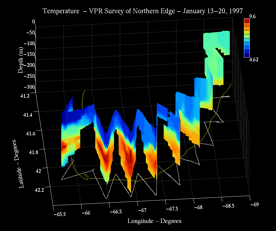
The hydrographic properties along the bank edge were highly structured both horizontally and vertically. The temperature structure in the Gulf of Maine revealed strong winter cooling at the surface and warmer waters at depth. Along the western edge of the bank (legs 1-4; Fig. 2), temperatures were well-mixed on the bank and down to 90-100 m in legs 1 and 2. Toward the end of leg 2, the deeper water (>70 m) was warmer (near 8 oC) and saltier (>33 psu) and had a lower fluorescence and higher beam attenuation. (note that Figures 2-6 are dot plots with dot color representing the value of the variable, scaled as shown. No spatial interpolation is performed in these plots. Every 30th point is plotted along the tow path representing an elapsed time of 2.5 to 5 seconds depending on whether the data were collected at 3 or 6 Hz). Fluorescence generally increased from west to east along legs 1-4 (Fig. 2). (note that the transmissometer data is suspect and requires further in-depth analysis; although the relative changes appear reasonable, the absolute magnitude of the attenuation varied greatly from west to east along the entire zig-zag transect.)
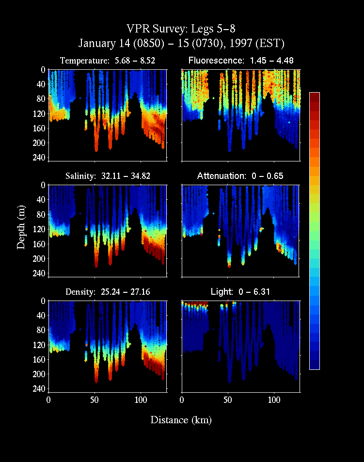
The vertical structure of the variables was pronounced in legs 5-8 (Fig. 3). Again, the water column was well mixed with respect to temperature, salinity, and fluorescence down to about 100 m. Surface temperatures were colder (< 6 oC) than in legs 1-4 and the deeper water (> 100 m) was warmer (>8 oC) and saltier (max = 34.82 psu). Fluorescence had a very similar pattern to temperature (but inversely related) (Fig. 3), with values changing markedly below 100 m. Highest values were found from the surface down to 100 m.
The west to east trend of decreasing temperature continued in legs 9-12 (<5 oC) (Fig. 4). Temperature, salinity, density, and fluorescence were well mixed down to 80-120 m, below which temperatures became much warmer (9.6 oC) than in legs 1-8 (Figs. 2 , 3). There appeared to be a shoaling of the isopycnals in moving into shallow waters between legs 9 and 10. Again, patterns in fluorescence followed those for temperature. Smaller scale patterns in these variables also can be seen, with a local temperature minimum appearing in the upper 40 m between 80-100 km along this section, and a local maximum appeared just below this surface feature at a depth of 150-180 m. Beam attenuation values were very large in the deeper regions of this section and in legs 13-17, but as mentioned before, these data require further analysis.
The minimum temperature was coldest in legs 13-17 at a value of 4.6 oC (Fig. 5). This cold water penetrated to a depth of about 70-80 m and had local horizontal maxima. The deep salty warm water was present below 80 m and also had local maxima. Below this deep warm water, a deeper cooler layer began to appear at the end of the transect. This water may represent an intrusion of deep slope water, but no salinity data are available for this last part since the conductivity probe began giving bad data after contact with the bottom midway along leg 16.
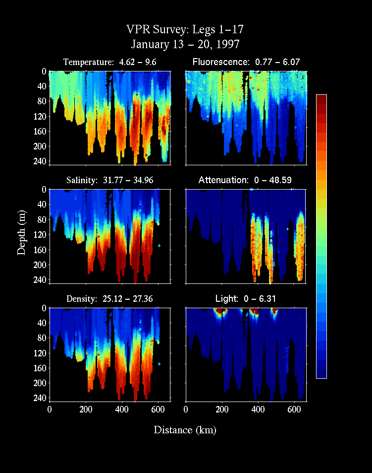
When all legs are plotted together (Fig. 6), the west to east trend toward colder temperature can be seen clearly. The temperatures on the western portion were more well mixed and had a value around 7 oC whereas the values in the eastern regions ranged from 4.6 - 9.6 oC. The colder surface water on the eastern end of the transect was also fresher and less dense. The salinity and density are seen to have highest values below 80 to 120 m. Both temperature and salinity appeared to shoal along the transect between the 200 - 500 km points in along-track distance and deepen again thereafter. Fluorescence was highest in the mid section of the transect (between 150 and 450 km) with lower values east and west of this region. The pattern in downwelling light shows the periods of day and night, indicating that most of the region was sampled during darkness. The two "patches" of attenuation may have been a faulty probe or A/D conversion, and again these data require further analysis.
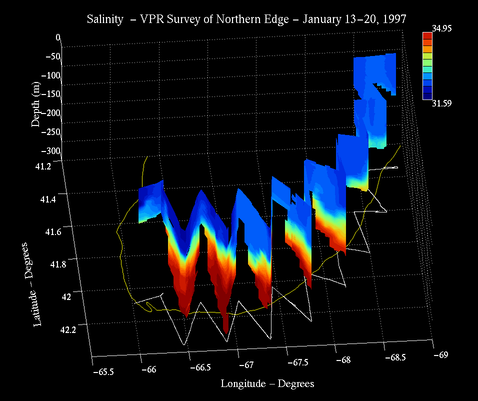
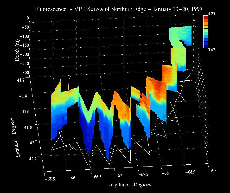
The three-dimensional distribution of temperature, salinity, and fluorescence can be seen in the color curtain plots for each variable (Figs. 7 8 and 9). The view in these figures is from the northeast looking toward the southwest. The cold fresh water in the northeast peak can be seen clearly in these figures as it extends toward the west along the north edge of the bank. The geometry of this cold fresh water mass in the surface water around the northeast peak suggests it resulted from an intrusion of Scotian Shelf water from the northeast.
This intrusion is evident in the satellite imagery on Jan 22 (Fig. 10; base image downloaded from
Bisagni's GLOBEC data archive). This image was taken 2 days after
our cruise ended and is the first cloud free image of Georges Bank
in January 1997. It can be seen in this figure that legs 12 to 17
of the zig-zag survey sampled this Scotian Shelf intrusion. The
survey showed that this water penetrated to a depth of 60-80 m at
the northeast peak of the bank ( Fig. 6).
The survey also revealed a subsurface temperature maximum over 9
oC that was not evident in the satellite image (Fig. 7). This water may have been a remnant
from the previous warm season that had not yet been convectively
cooled. The highest fluorescence in the Gulf of Maine water was
associated with the leading portion of the intrusion (from 200-400
km).
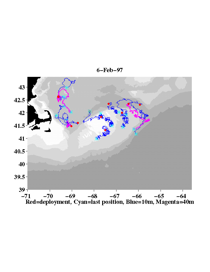
3.2 Drifter movements and Initial Tracks
Shortly after deploying the deep and shallow drifters north of
the northeast peak in the Gulf of Maine, the winds blew from the
southwest at 50-60 knots for a 24 hr period. The shallow drifter
(Fig. 11; thin line) moved to the
southeast about 40 km during this short period. The deep drifter
(thick line) on the other hand remained in place and showed no
apparent translation from the strong wind forcing. This deep
drifter was well within the Scotian Shelf water intrusion,
indicating that the intrusion itself may have been little affected
by this storm. The deep drifter moved toward the southeast across
the northeast peak over a 12 day period indicating that the
intrusion may have a net movement clockwise around the northeast
peak and not westward as the satellite image suggests. The drifters
deployed in the Gulf of Maine north of the Great South Channel did
not move onto the bank over a 15 day period. Instead, these
drifters had a net movement in the opposite direction, toward
Wilkinson Basin. The two other drifters launched in the Gulf of
Maine did move onto the bank during this period.
3.3 ADCP measurements
The hull-mounted ADCP was run continuously during the cruise.
The raw data are stored on disk archives and await processing.
3.4 Underway data
The ships flow-through measurement of temperature, salinity, and
fluorometry collected data continuously while underway. These data
also are stored on disk archives and await processing.
4.0 Conclusions
In general, the cruise was marginally successful. Due primarily
to bad weather, we did not have time to conduct repeated
realizations of the zig-zag survey as originally planned. Nor were
we able to conduct repeated tidally resolved transects at selected
locations on the northern edge. The latter would have enabled us to
measure flux of copepods directly. In addition to bad weather, we
lost 1.5 days to equipment problems. Our engineering team failed to
have the automatic video processing system working properly for this
cruise as was originally intended. We thus were unable to acquire
data on the distributional patterns of the animals in real time.
Nonetheless, we were able to obtain high resolution distributional
data on hydrography, currents, fluorescence, and plankton taxa and
size composition. The data on currents and plankton remains to be
analyzed. Video processing will be performed on the tapes and these
data together with the ADCP current measurements will allow us to
measure flux of the copepods onto the bank, which was our primary
goal.
Appendix I.
Personnel List
| Name | Title | Organization |
| Cabell Davis | Chief Scientist | WHOI, Woods Hole, MA |
| Scott Gallager | Associate Scientist | WHOI, Woods Hole, MA |
| Carin Ashjian | Assistant Scientist | WHOI, Woods Hole, MA |
| Xiaoou Tank | Postdoctoral Investigator | WHOI, Woods Hole, MA |
| Andrew Girard | VPR Technician | WHOI, Woods Hole, MA |
| Fernando Serra | Software Technician | Imaging Technology, Inc. |