EN319 CRUISE REPORT
21 February - 4 March, 1999
Acknowledgments: We wish to thank the crew of the R/V Endeavor for their professionalism and friendly support. Their cooperation and assistance made the success of this cruise possible.
This cruise was sponsored by the National Science Foundation and prepared by Ted Durbin, Jeff Runge, Melissa Wagner, and Barbara Niehoff.
TABLE OF CONTENTS
Introduction............................................................................3
Cruise Narrative.....................................................................4
Hydrography..........................................................................5
Chlorophyll and Nutrients....................................................13
Zooplankton Abundance.......................................................15
Egg Production Studies.........................................................25
List of Scientific Personnal....................................................26
Event Log...............................................................................27
INTRODUCTION
The
objective of the cruise was to determine egg production and growth rates, and
physiological condition and mortality rates of the dominant copepod species on
Georges Bank including the target species Calanus
finmarchicus and Pseudocalanus.Ā The general plan was to deploy ARGOS-tracked
drogues on the NE Peak of Georges Bank and follow these for 8-10 days.Ā Each day we planned to carry out a CTD and
bottle cast (for chlorophyll a determinations) next to the drifter and sample
the zooplankton with a plankton pump (5 replicate profiles) and a bongo net (3
profiles).Ā AtĀ the same time we planned to carry out molting rate and egg laying
rates on the Calanus finmarchicus.Ā From these measurements we planned to
determine stage specific mortality rates of Calanus
using the population surface method and the vertical life table approach.Ā At the beginning of the drifter deployment
and every other day subsequently we planned to carry out a 1 m2 MOCNESS tow to
collect potential invertebrate zooplankton predators.Ā Prior to deployment of the drifters we planned to carry out
several CTD and bongo transects in an east-west direction between the 60 and
200m depth contours on the NE Peak.Ā
Information from these transects was intended to enable us to determine
a suitable location for deployment of the drifters.
Following the drifter tracking study we planned to carry out a study of the abundance, stage and depth-distribution of Calanus, as well as determining egg laying rates and physiological condition, along transects in the Gulf of Maine.Ā The objective was to determine the reproductive status of the overwintering Calanus population in the Gulf of Maine prior to the occurrence of the spring phytoplankton bloom.Ā The first transect was planned to begin on the NE Peak and extend north to Maine Coastal waters adjacent to Mt. Desert Island.Ā The second was to extend west across the Gulf to Cape Cod Bay.Ā At each station we planned to deploy the CTD and collect water for chlorophyll a, carry out MOCNESS and pump deployments, and collect live animals for experiments.Ā Stations were to be approximately 30 miles apart.
Because of extremely bad weather throughout the cruise with a succession of storms passing through we were unable to achieve most of these objectives. The cruise was initially delayed several days because of weather.Ā When we reached the NE Peak of Georges Bank to begin the initial transects conditions were too rough to work.Ā A major storm was forecast so we left to shelter in Portland, Maine. At this stage there was insufficient time to complete the planned drifter study. On returning from Portland we carried out a transect across the Gulf of Maine from Maine coastal waters at the mouth of Penobscot bay, across Jordan and Georges Basins, and onto Georges Bank, sampling zooplankton with a pump and Mocness, carrying out egg laying experiments, collecting animals for RNA/DNA measurements, and measuring growth and molting rates. This transect was also interrupted by weather. At the end of the transect we planned to carry out several diel studies of Calanus egg laying on Georges Bank. Bad weather prevented even these limited objectives so we returned to Narragansett.
Although most of our initial objectives were not met, we considered that the N-S Gulf of Maine transect provided useful and new information for this region during the winter.
CRUISE NARRATIVE
We left GSO on Sunday, 21 February at 09:15 after a two delay due to bad weather.Ā We proceeded out through Buzzards Bay, Cape Cod Canal and to our station on the NE Peak of Georges Bank, arriving at the station at 08:00 am on the 22nd. Shortly before we arrived winds picked up to over 30 kts, gusting up to 40, and after readying the CTD for deployment we decided that conditions were too severe to start work.Ā We began jogging slowly.Ā Winds were predicted to remain between 30-40 for the rest of the day and we didnÆt expect to begin work until early Tuesday.
On Tuesday morning winds were still blowing around 30 kt and air temperatures were -7.0 C.Ā However, winds were slowly decreasing so we turned around (during the storm we had jogged about 25 miles N of the station) and steamed back to the station (St 1), arriving there around 13:30.Ā We carried out a CTD cast collecting water for chlorophyll.Ā We then carried out two live tows with a 156 Ąm, 1 m diameter net towed between the surface and near the bottom (47 m).Ā Conditions during the casts were marginal and it would not have been possible to carry out either a 1 m2 MOCNESS tow or a plankton pump cast.Ā At the end of the station the Captain came down with news of more bad weather predicted for the Gulf of Maine and Georges Bank (storm level winds) beginning Wednesday night and wanted to break off work and head into shelter.Ā Portland, Maine was decided upon since we felt it would provide an opportunity to carry out a transect from N to S in the Gulf of Maine as we returned to Georges Bank.
The live tows, meanwhile, were immediately sorted for Calanus and Pseudocalanus adult females and Calanus older stage copepodites.Ā Groups of Calanus were preserved for RNA/DNA measurements.Ā Additional females were sorted for egg laying measurements (Runge/Joly) and to lay eggs for the production of nauplii which would be used when we return to the bank in feeding experiments (Sandrin).Ā Calanus was quite sparse at the station.Ā Other copepods present included Metridia, Pseudocalanus, Oithona and Centropages.
We arrived in Portland on 24 February and departed at 06:00 on the 27th and headed out to the first station of our N-S Gulf of Maine transect off Manincus Island at the mouth of Penobscot Bay. The general approach at each station was to carry out a CTD and collect samples for nutrients and chlorophyll a, do a 1 m2 MOCNESS and a pump cast, and then collect live animals for sorting for egg laying experiments with Calanus and Pseudocalanus.Ā At each station a 75 Ąm mesh net tow was preserved for egg ratio estimates of egg production by Pseudocalanus.Ā Subsamples were taken from surface and deep MOC nets for RNA/DNA and C & N measurement on older stager copepodites and adult females of Calanus.Ā At every other station Calanus nauplii were sorted for RNA/DNA.
ĀThe weather was great for two days and we completed two stations (St 2 and 3) the first day and then broke of for the night so that we could collect live animals during daylight at St 4.Ā At St 2 we were in the lower salinity Maine Coastal Current.Ā Calanus was present, both adults and nauplii, as well as Metridia and two spp of Pseudocalanus.Ā At St 3 there were fewer Pseudocalanus and Calanus, but large numbers of Metridia.Ā St 4 was started first thing in the morning and we completed 5 and 6 during the day.Ā There was much large Rhizosolenia at these stations and appeared to be fewer Calanus nauplii.Ā By evening the wind was picking up and since it was predicted to blow 30-40 kts overnight and the next morning we stowed everything on deck away.Ā The next morning (March 1st) was warmĀ with the wind between 20 and 30 but the seas were large and confused.Ā It rained off an on.Ā By midday the wind began to drop but the seas remained large preventing any work being done that day.Ā By 2000 hrs we decided to proceed to the NE Peak of Georges Bank to begin the 36 hr station the following morning.Ā The swell was still large by morning but we took net tows at St 7 to see if the Calanus populations were suitable for the study of diel periodicity in egg laying and diel changes in egg and naupliar abundance in the water column.Ā Unfortunately Calanus abundance was very low and it was not a good location for the study.Ā We then completed regular sampling atĀ the station and then headed north back to the Gulf of Maine to complete the last station on the GOM transect. This was completed at night in some rather wild conditions with the wind blowing around 30 kts and large swells.Ā Everything was completed, however, with no mishaps.Ā
A large storm was predicted for Thursday with 40-45 kt winds on Georges bank.Ā This would preclude us carrying out any time series study in the GOM or on GB before we had to leave on Friday to come in.Ā We decided to head into sheltered waters in Massachusetts Bay to see if we could find sufficient animals to carry out the 36 hr study in sheltered waters while the storm was blowing.Ā We stopped in the western Wilkinson Basin and collected Calanus for experiments and proceeded to a location just inside Stellwagen Bank in Massachusetts Bay.Ā Unfortunately a net tow revealed very few Calanus and incredibly large numbers of phytoplankton which clogged even a 333 Ąm net which precluded us from carrying out the 36 hr study at this location.Ā The weather forecast at this point was predicting high wind and 22 ft seas for the following day in the S Gulf of Maine Georges Bank area.Ā At this point we decided to return to Narragansett since we would not have been able to accomplish anything significant on Friday morning (if we were able to work at all), before having to break off to return to Narragansett on Sat.
Individual reports follow.
HYDROGRAPHY
CTD profiles for St 2-8 are shown in Figures 2-9. Adjacent to the Maine coast at St 2Ā (Fig. 2) water was mixed to the bottom (120m) with temperature about 3.7 and salinity 32.5. Chlorophyll fluorescence was low. Across the Gulf at Sts 3-6 the surface mixed layer extended down to about 60m and there was high chlorophyll fluorescence within this layer. Surface temperature was between 3.5 and 4.5 and salinity between 32.4 and 32.6. At St 8 adjacent to Georges Bank the mixed layer extended down to 100m, the temperature warmer than at other stations in the GOM (5.2 C), and chlorophyll fluorescence low (Fig 8). On Georges Bank (St 7) there were suggestions of a slightly colder fresher layer at the surface and then a well-mixed water column beneath this (Fig 9). Water temperature and salinity was higher than in the GOM (6 C and 33 respectively).

ĀĀĀĀĀĀĀĀĀĀĀĀĀĀĀĀĀĀĀĀĀĀĀĀĀĀĀĀĀĀĀĀĀĀĀ Figure 2. Station 2 CTD profiles

ĀĀĀĀĀĀĀĀĀĀĀĀĀĀĀĀĀĀĀĀĀĀĀĀĀĀĀĀĀĀĀĀĀĀĀ Figure 3. Station 3 CTD profiles
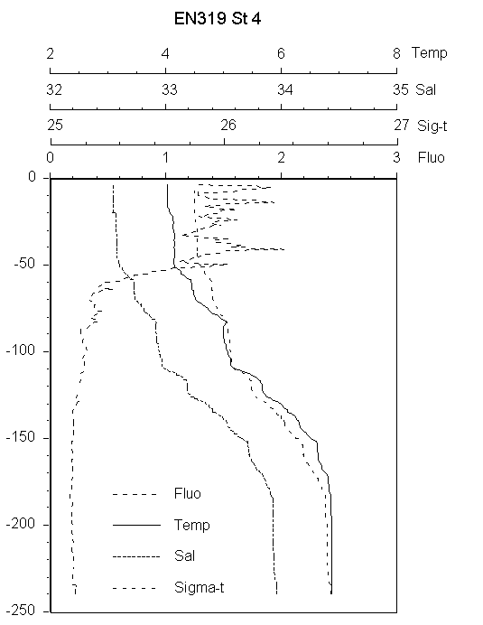
ĀĀĀĀĀĀĀĀĀĀĀĀĀĀĀĀĀĀĀĀĀĀĀĀĀĀĀĀĀĀĀĀĀĀĀ Figure 4. Station 4 CTD profiles
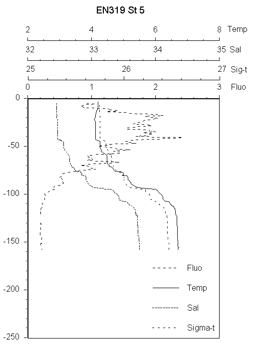
ĀĀĀĀĀĀĀĀĀĀĀĀĀĀĀĀĀĀĀĀĀĀĀĀĀĀĀĀĀĀĀĀĀĀĀ Figure 5. Station 5 CTD profiles
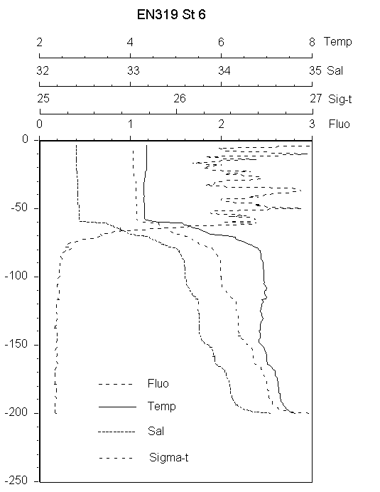
ĀĀĀĀĀĀĀĀĀĀĀĀĀĀĀĀĀĀĀĀĀĀĀĀĀĀĀĀĀĀĀĀĀĀĀ Figure 6. Station 6 CTD profiles
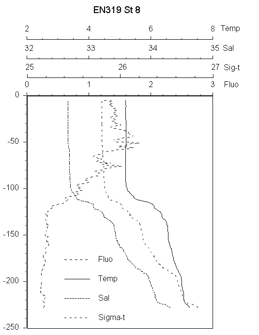
ĀĀĀĀĀĀĀĀĀĀĀĀĀĀĀĀĀĀĀĀĀĀĀĀĀĀĀĀĀĀĀĀĀĀĀ Figure 8. Station 8 CTD profiles

ĀĀĀĀĀĀĀĀĀĀĀĀĀĀĀĀĀĀĀĀĀĀĀĀĀĀĀĀĀĀĀĀĀĀĀ Figure 7. Station 7 CTD profiles
CHLOROPHYLL and NUTRIENTS
At each station size-fractionated chlorophyll a (<5Ąm and Total) and nutrients (NH4, NO3,Ā NO2, PO4) were measured at 10 m intervals down to 60 m and at the bottom. Values are shown in Table 02. At St 2 in Maine Coastal Water chlorophyll a was <1 Ąg l-1 with most being in the <5 Ąm fraction suggesting that the spring bloom had not yet begun. Nitrate and phosphate were high (>10 ĄM and > 1.0 Ąm) and the same throughout the 112 m water column. At St 3-6 across the Jordan and into the northern edge of Georges Basin total chlorophyll a was between 2 and 7 Ąg L-1. Most of the phytoplankton was in the larger size-fraction. Nitrate and phosphate were lower than in Maine Coastal Water and decreased from towards the south (St 6) where nitrate was around 6 ĄM and phosphate 0.7 ĄM. These higher chlorophyll values coupled with lower nutrients, indicated that the spring bloom had already begun. This is very early for the central Gulf of Maine where typically high chlorophyll values are not seen until April and May (OÆReilly and Zetlin 1999). Perhaps it reflected the calmer weather experienced up until the time of the cruise.
|
Table 1. Chlorophyll a and
nutrients from EN319. |
||||||
|
|
|
|
|
|
|
|
|
Station |
Depth, m |
<5 Ąm Chl a |
>5 Ąm Chl a |
Total Chl a |
DIP |
NO3 |
|
|
|
ug L-1 |
ug L-1 |
ug L-1 |
uM |
uM |
|
1 |
0 |
0.58 |
1.17 |
1.75 |
|
|
|
1 |
5 |
0.50 |
1.01 |
1.51 |
|
|
|
1 |
10 |
0.67 |
0.92 |
1.59 |
|
|
|
1 |
20 |
0.53 |
1.26 |
1.79 |
|
|
|
1 |
30 |
0.54 |
1.13 |
1.67 |
|
|
|
1 |
40 |
0.63 |
1.12 |
1.75 |
|
|
|
1 |
44 |
0.49 |
0.94 |
1.43 |
|
|
|
|
|
|
|
|
|
|
|
2 |
0 |
0.40 |
0.20 |
0.60 |
1.10 |
11.04 |
|
2 |
5 |
0.40 |
0.40 |
0.80 |
1.07 |
10.82 |
|
2 |
10 |
0.40 |
0.10 |
0.50 |
1.07 |
10.61 |
|
2 |
20 |
0.38 |
0.29 |
0.67 |
1.08 |
10.72 |
|
2 |
30 |
0.40 |
0.14 |
0.54 |
1.13 |
10.73 |
|
2 |
40 |
0.30 |
0.06 |
0.37 |
1.08 |
10.93 |
|
2 |
60 |
0.27 |
0.33 |
0.60 |
|
|
|
2 |
112 |
|
|
|
1.12 |
10.93 |
|
|
|
|
|
|
|
|
|
3 |
0 |
0.75 |
2.06 |
2.81 |
0.99 |
8.66 |
|
3 |
5 |
0.80 |
2.16 |
2.96 |
0.96 |
8.70 |
|
3 |
10 |
0.95 |
1.86 |
2.81 |
0.94 |
8.45 |
|
3 |
20 |
0.80 |
2.11 |
2.91 |
0.96 |
8.64 |
|
3 |
30 |
0.90 |
1.61 |
2.51 |
0.95 |
8.77 |
|
3 |
40 |
0.85 |
1.76 |
2.61 |
0.95 |
8.61 |
|
3 |
60 |
0.05 |
0.15 |
0.20 |
0.94 |
8.58 |
|
3 |
168 |
|
|
|
1.35 |
13.86 |
|
|
|
|
|
|
|
|
|
4 |
0 |
0.66 |
1.97 |
2.63 |
0.93 |
8.19 |
|
4 |
5 |
0.73 |
1.74 |
2.47 |
0.90 |
8.20 |
|
4 |
10 |
0.73 |
1.55 |
2.28 |
0.90 |
8.19 |
|
4 |
20 |
0.70 |
1.82 |
2.51 |
0.90 |
8.23 |
|
4 |
30 |
0.66 |
1.58 |
2.24 |
1.00 |
8.46 |
|
4 |
40 |
0.31 |
0.73 |
1.04 |
1.24 |
8.86 |
|
4 |
50 |
0.02 |
0.01 |
0.04 |
1.11 |
9.69 |
|
4 |
239 |
|
|
|
1.55 |
18.99 |
|
|
|
|
|
|
|
|
|
5 |
0 |
0.66 |
2.32 |
2.98 |
0.83 |
7.06 |
|
5 |
10 |
0.58 |
2.43 |
3.01 |
0.84 |
7.01 |
|
5 |
20 |
0.77 |
2.09 |
2.86 |
0.81 |
7.12 |
|
5 |
30 |
0.70 |
2.43 |
3.13 |
0.84 |
7.27 |
|
5 |
40 |
0.71 |
4.18 |
4.89 |
0.82 |
7.05 |
|
5 |
60 |
0.70 |
2.40 |
3.09 |
0.84 |
7.32 |
|
5 |
157 |
|
|
|
1.39 |
16.83 |
|
|
|
|
|
|
|
|
|
6 |
0 |
0.62 |
2.28 |
2.90 |
0.75 |
6.25 |
|
6 |
10 |
0.77 |
2.47 |
3.25 |
0.72 |
6.09 |
|
6 |
20 |
0.70 |
2.16 |
2.86 |
0.74 |
6.22 |
|
6 |
30 |
0.62 |
6.34 |
6.95 |
0.73 |
6.27 |
|
6 |
40 |
0.77 |
2.05 |
2.82 |
0.72 |
6.27 |
|
6 |
60 |
0.85 |
2.32 |
3.17 |
0.79 |
7.18 |
|
6 |
199 |
|
|
|
1.39 |
19.81 |
|
|
|
|
|
|
|
|
|
8 |
0 |
0.62 |
1.35 |
1.97 |
0.90 |
8.96 |
|
8 |
10 |
0.73 |
0.89 |
1.62 |
0.90 |
8.78 |
|
8 |
20 |
0.77 |
1.08 |
1.85 |
0.92 |
8.70 |
|
8 |
30 |
0.77 |
1.24 |
2.01 |
0.90 |
8.99 |
|
8 |
40 |
0.93 |
1.24 |
2.16 |
0.91 |
8.98 |
|
8 |
60 |
0.66 |
1.12 |
1.78 |
0.93 |
8.93 |
|
8 |
226 |
|
|
|
1.47 |
18.40 |
|
|
|
|
|
|
|
|
|
7 |
0 |
0.58 |
1.28 |
1.85 |
0.80 |
10.05 |
|
7 |
10 |
0.35 |
1.12 |
1.47 |
0.80 |
7.66 |
|
7 |
20 |
0.35 |
1.12 |
1.47 |
0.81 |
7.93 |
|
7 |
30 |
0.46 |
1.39 |
1.85 |
0.81 |
7.93 |
|
7 |
40 |
0.39 |
1.51 |
1.89 |
0.82 |
7.95 |
|
7 |
66 |
0.62 |
1.08 |
1.70 |
0.76 |
8.03 |
ZOOPLANKTON ABUNDANCE
Below we present zooplankton pump counts.Ā At this stage the MOCNESS samples have not been enumerated.
Plankton Pump Counts. Zooplankton pump samples were collected and counted using standard GLOBEC Broadscale Survey Procedures.Ā Samples were normally collected from 100-70m, 70-40m, 40-15m and 15-0m. Table 2 shows the abundance of Calanus finmarchicus stages for the different depths, while Table 3 shows the total abundance of Calanus over the whole water column at each station. At all stations there was a population of young nauplii and copepodites. Abundance of nauplii was lowest at St 8, adjacent to Georges Bank (8,700 m-2); elsewhere across the Gulf numbers were between 23,000 (St 2) and 55,000 m-2 (St 5). On Georges Bank (St 7) abundance of Calanus nauplii was higher (76,000 m-2), but there were relatively fewer older stages present compared with St 2-6 in the Gulf of Maine.
Other abundant copepod nauplii included Oithona, Calasocalanus/Paracalanus, Metridia and Pseudocalanus (Table 5). Oithona was particularly abundant with total numbers >1,000,000 m-2 at all stations but St 2 and 4. Microsetella was quite abundant but was present mostly as copepoidites at depth.