Table of Contents
Hydrography (David Mountain and Cristina Bascunan)
Preliminary Summary of Ichthyoplankton Findings (Rebecca Jones and John Sibunka)
Preliminary Summary of the 10-m2 MOCNESS samples (Maria Casas and Stephen Brownell)
Population Genetic Studies of Zooplankton (Ann Bucklin and Sara Smolenack)
Calanus Life History Studies (Jennifer Crain)
Zooplankton Predator Sampling (Larry Madin, Steve Bollins, Erich Horgan; and Annette Friese)
Phytoplankton Chlorophyll, Nutrients and Light Attenuation Studies (David Townsend)
Stable Isotope Analysis of Particulate and Zooplankton Samples (Karen Fisher)
High Frequency Acoustics (Peter Wiebe and Karen Fisher)
Appendix I. Event log for Broadscale Survey cruise EN-320.
Appendix II. CTD Profiles for Standard Stations sampled during EN-320
R/V ENDEAVOR (Cruise EN-320)
U.S. GLOBEC Broadscale Survey
March 10 - 23, 1999
The U.S. GLOBEC Georges Bank Program is now into its fifth full field season and this cruise was the third in a series of six Broadscale cruises taken place at monthly intervals between January and June. Our specific objectives were:
1) To conduct a Broadscale survey of Georges Bank to determine the abundance and distribution of U.S. GLOBEC Georges Bank Program target species which are the eggs, larval, and juvenile cod and haddock and the copepods Calanus finmarchicus and Pseudocalanus spp.
2) To conduct a hydrographic survey of the Bank.
3) To collect chlorophyll data to characterize the potential for primary production and to calibrate the fluorometer on the CTD.
4) To map the bank-wide velocity field using an Acoustic Doppler Current Profiler (ADCP).
5) To collect individuals of C. finmarchicus, Pseudocalanus spp., and the euphausiid, Meganyticphanes norvegica, for population genetic studies.
6) To conduct lipid biochemical and morphological studies of C. finmarchicus.
7) To conduct acoustic mapping of the plankton along the tracklines between stations using a high frequency echo sounder deployed in a towed body.
8) To deploy drifting buoys to make Lagrangian measurements of the currents.
The cruise track was determined by the position of the 41 "Standard" Stations that form the basis for all of the Broadscale cruises (Fig. 1). All of Georges Bank, including parts that are in Canadian waters, was surveyed.
The work was a combination of station and underway activities. The along-track work consisted of high frequency acoustic measurements of volume backscatter of plankton and nekton throughout the water column and surface measurements of temperature, salinity, and fluorescence from the towed body. The ship's 150 kHz ADCP unit was used to make continuous measurements of the water current profile under the ship, in order to construct the current field over the whole of Georges Bank. Meteorological data, navigation data, and sea surface temperature, salinity, and fluorescence data were measured aboard the R/V ENDEAVOR.
A priority was assigned to each of the 41 standard stations that determined the equipment that was deployed during the station's activities. At high priority "full" stations, a Bongo net equipped with a SeaBird CTD was towed obliquely to near the bottom. A CTD (equipped with a fluorometer and transmissometer) profile to the bottom was made and rosette bottles collected water samples for salinity and chlorophyll calibrations, chlorophyll concentrations, phytoplankton species counts, and 18O/16O water analysis. A large volume zooplankton pumping system was used to profile the water column. A 1-m2 MOCNESS was towed obliquely to make vertically stratified collections for zooplankton (150 μm mesh) and then to make collections of fish larvae (335 μm mesh). Weather permitting, a 10-m2 MOCNESS was towed obliquely to make vertically stratified collections of juvenile cod and haddock, and the larger predators of the target species. At lower priority stations, a Bongo tow, CTD profile, and 1-m2 MOCNESS tow were made. At some stations, the SeaBird CTD/Niskin bottle cast was made for calibration purposes. A summary of the sampling events that took place during the cruise is provided in Appendix I.
Day 1: Wednesday, March 10th
Our departure was delayed from the originally-scheduled 1100 hr, to await arrival of a reconditioned block and to allow time for Peter Wiebe to splice the Greene Bomber cable. Peter, the new cable, and the reconditioned block arrived at 1400 hr. After a quick check-out and pool test of the Greene Bomber, we were all set to go. We held a science meeting at 1630 hr to go over changes and additions since the last cruise, and to lay out a time-table for the first watches. Lines were dropped at 1715 hr with sunny skies and breezy, cold conditions. We steamed away from the dock far enough to swing the 10-m2 MOCNESS, setting the cable termination.
Day 2: Thursday, March 11th
Our weather window continued, with light winds, choppy seas, and heavy overcast. We arrived at the first station at 0800 hr. Bill Fanning took both watches through deployment of all the gear. With gear delays and demonstrations, it turned out to be a longish station even as first stations go. Day watch worked at Stations 2 and 41, completing all but the 1-m2 MOCNESS recovery before midnight. Weather choppy and wet, but workable.
Day 3: Friday, March 12th
Work continued, with the long steams between stations over this portion of the Bank seeming to slow our progress. Worsening conditions shut down work on the nightwatch. Day watch got back to work with calming winds, taking over a pump deployment at Station 3 at the start of the watch. Despite waves breaking over the rail and vertiginous plunges of the fantail, station work was done without incident. Night watch sat out the steam, and day watch worked Station 4. All the gear seemed to be working well, including the Greene Bomber - with the exception of a mysterious malfunction of the conductivity probe.
Day 4: Saturday, March 13th
Work at Station 5 was completed by the nightwatch without difficulty. The 1-m2 MOCNESS developed an intermittent problem, losing contact with the options module and/or the underwater unit shortly after immersion. Despite replacing the battery, the problem continued. After an aborted tow, the 1-m2 MOCNESS was replaced with a bongo at Station 6. A bongo again replaced the 1-m2 MOCNESS at Station 7, due to continued electronic problems in addition to deteriorating weather conditions. Work ceased at 1600 hr in rising winds and seas, and the ship was secured for weather. We hove to on the way to Station 8, steaming slowly into the North-Northeast winds at 1 kt. The ride remained comfortable enough, although the night watch did no work.
Day 5: Sunday, March 14th
Winds and seas calmed enough in the morning to begin work on Station 8 at 0800 hr, with the start of the day watch. The 1-m2 MOCNESS behaved itself well enough to complete the tow. The system worked better when the transmissometer was deselected; it was decided to deploy the 1-m2 MOCNESS with the options module deselected if necessary. This seemed to solve the problem, isolating the problem to the fluorometer, transmissometer, or their cables.
Station 9 was occupied during the afternoon. A slow (5 m/min) vertical “jel net” (i.e., a bongo with 1000 um mesh net) tow was done for Larry Madin, with another, faster tow of the same net for his student, Annette Friese, to collect swimming predators. Despite dire predictions of storms, gales, and 50 knot winds, we continued working through the day, completing work at Station 10 before midnight.
Day 6: Monday, March 15th
In curiously calm and flat conditions, the nightwatch completed our first “perfect” station, including pump and 10-m2 MOCNESS deployment, at Station 12. The wind sprang up just as the 10-m2 MOCNESS nets were being lashed down. Weather conditions worsened through the early morning. The decks were secured for weather at 0845 hr, postponing work at Station 13 until after the coming gale. Captain McMunn plans to take the ship into deeper waters to the south and east of the Bank.
Day 7: Tuesday, March 16th
Hove to all day for weather. Winds gusting over 50 knots, slowly coming around from North to West as the day progressed. We kept into the wind to the south of the Bank. We held a short science meeting at 1600 hr to develop a strategy to make up time lost. The decision was made to curtail station work at most stations (dropping the 10-m2 MOCNESS at priority 1 stations; the pump at priority 2 stations; replacing the 1-m2 MOCNESS with a bongo at priority 3 stations; and omitting priority 4 stations). During fair weather, the Bridge was asked to proceed toward the next station as soon as all gear was on deck. We will keep to this plan through Station 25, at which time we will re-evaluate our progress and develop a strategy for the remainder of the cruise.
Nightwatch sat through the last of the 48 hr weather downtime, with Neile and Christina using the time to make St. Patrick’s Day favors for a “Stupid Hat Party”. Winds had lessened to 30 kts by midnight and continued to fall through the night.
Day 8: Wednesday, March 17th
By daybreak, conditions were workable. The ship turned around and steamed east back toward Station 13. The daywatch unsecured the decks to prepare for work. We discovered that one of the stanchions holding the 1-m2 MOCNESS was severed and a net was ripped (which was then swapped out). We reached Station 13 at 0850 hr, and completed planned work without incident. Stations work required only one hour - much easier and quicker in good working conditions. The watches split the work at Station 14, a priority 3 station, with a bongo-bongo-CTD series. The pace of work picked up with good working conditions and truncated station work. Station 15 was skipped, with only an intermediate bongo at the spot. Work proceeded well at Station 16 until just prior to the 1-m2 MOCNESS deployment, when we decided to change out the battery for the long (3 hr +) tow. After the battery replacement, the sea cable linking the deck box and the underwater unit could not be set up. After an hour of trouble-shooting with E.T. Bill Fanning and others (during which the battery cable was replaced, a dummy plug replaced a smashed transmissometer, and all cables were checked), the problem was resolved by using the 10-m2 MOCNESS sensor package. The tow was completed successfully, except for a malfunctioning flourometer, with recovery after 0000 hr. The cause of the failure remained unclear, since the 1-m2 MOCNESS had performed flawlessly on the previous tow. It seemed possible that the system was damaged during the stanchion repairs, which were also thought to have caused the damage to the transmissometer.
Day 9: Thursday, March 18th
Weather continued workable, with a partly sunny and warm morning threatening some rain. Station 17 was completed by the nightwatch, with the daywatch taking over for the intermediate bongo. The Greene Bomber was recovered, checked, and redeployed during Station 18. Both watches kept a rapid pace, working through stations as efficiently as possible. Continuing the dubious record-setting nature of the cruise, David Mountain claimed that work at Station 19 was completed in just 34 min - confirming the time saving we will achieve by trimming priority 3 station work to two bongo tows and a CTD cast. By 2100, work at Station 20 began. The 1-m2 MOCNESS, the last deployment, was cocked and wrapped by midnight. We headed immediately for Station 21 on a southeastward course. During the station work, the winds came up some, gusting to 30 kts out of the southwest. The pump tank and surge suppressor were pulled back off the starboard rail and lashed amidships, to protect the gear from the weather.
Peter Wiebe and David Mountain examined the data from the 1-m2 MOCNESS fluorometer and transmissometer and concluded that neither sensor worked during any cast on this cruise, nor on the previous two cruises. These data should be discarded. After testing, it was also clear that the 1-m2 MOCNESS underwater unit is non-functional and will require repair. Bill Fanning summarized the current status of the URI 1-m2 MOCNESS unit in a memo to Bill Freitag. The entire system is in need of overhaul; this conclusion was included in the recommendations section of the narrative.
Day 10: Friday, March 19th
Blue skies, fair winds, and a few white caps this morning: the day began very well. The predicted overnight gale only resulted in 30 kt winds and kicked up the sea a bit. Just after the morning watch change, the 1-m2 MOCNESS deployment at Station 23 was completed, the Greene Bomber was recovered and secured on deck, and we headed for Station 39 at 13 kts.
A science meeting was held at the watch change at 1600 hr to formulate a strategy for the remainder of the cruise. Working backward from our desired arrival time, we built a schedule in which all remaining stations were to be occupied, with station work trimmed. Plan “B” called for dropping all 10-m2 MOCNESS deployments, dropping pump deployments at priority 2 stations, and replacing 1-m2 MOCNESS deployments with bongos at priority 4 stations. This plan should have us wrapping up work at 2200 hr on Monday. We discussed with Captain McMunn the possibility of stopping at Woods Hole to off-load all heavy gear. If the sea state allows us to cross Nantucket Shoals, we should be able to make Woods Hole on the morning high tide (beginning 0800 hr) and then Narragansett on the afternoon tide (no later than 1630 hr). In the event of foul weather, we will head around the shoals and plan for a 1200 hr arrival in Narragansett.
Work continued despite some heavy weather during the night. At Station 26, the wind came up, making for a cold and wet recovery of the 1-m2 MOCNESS. Decks awash as typical this cruise. A curious Canadian fishing vessel; appeared to follow us during 1-m2 MOCNESS deployment.
Day 11: Saturday, March 20th
Nightwatch completed work at Station 28 and deployed one pair of drifters. Daywatch took over for the second and third pairs of drifter deployments. We then delayed the intermediate bongo tow for an abandon-ship drill, with testing of survival suits. We worked to our “Plan B” schedule, gaining some time on the schedule during the morning. Nightwatch finished Station 29 in the afternoon, and the daywatch occupied Station 30 in the evening. The CTD cast was redone after the 1-m2 MOCNESS deployment. The problem on the first cast - discovered after testing eliminated all other causes - was only cock-pit error. Conditions continued calm, with the seas about as flat as we had seen them this trip.
Day 12: Sunday, March 21st
Keeping to Plan B, we continued moving through the stations at a good clip. The morning weather forecast predicted a storm by Monday night, again casting the completion of all station work again in doubt. Captain McMunn laid out a plan to return via the Cape Cod Canal, and left open the idea of stopping in Woods Hole to off-load gear. We planned to continue working according to plan through Station 35, at which point we would decide whether to head immediately for Station 38 (with the possibility of ending our work after that) or to continue on course to Station 36.
This day was beautiful - warm (for March) and sunny, with light winds and a low chop. At noon, during work at Station 33, we moved and secured the 10-m2 MOCNESS for our return. We held a quick science meeting at the 1600 hr watch change to decide on a plan for the remainder of the cruise. We will keep to Plan B station work, working Stations 34, 35, 36, and 38, replacing Station 37 with a double bongo on the track between Stations 36 and 38. According to this plan, we will finish work just after 1200 hr on Monday, with possible arrival in either Woods Hole or Narragansett by Tuesday morning.
Figure 2 (above). Graphs of underway measurements for wind speed (kts), air temperature (oC), sea surface temperature (oC), and barometric pressure (mlb) during the March, 1999 Broadscale Survey cruise (EN-320). March 15th (day 74) provided a brief respite during a rough cruise, enabling us to complete the only MOC-10 deployment of the entire cruise.
Figure 3 (below). Duration of wind speed (in 5 kts intervals) based on SALE system data. Winds blew better than 30 kts for 14% of time during EN-320. More than half the cruise was spent in winds greater than 20 kts.
Winds reached 25 - 30 kts during work at Station 36. Despite seas over the rail, we completed all deployments, including the pump, without incident and on schedule.
Day 13: Monday, March 22nd
With following seas, we steamed off the Bank toward Station 38 with the Greene Bomber in the water for the final transect. Surprisingly, the winds did not continue to build through the night, and conditions were workable (with 35 kts of wind) when we reached Station 38 at 0530 hr. We deployed the 1-m2 MOCNESS first, then did bongo and jel-net tows, and the final CTD cast, but were unable to deploy the pump in the marginal working conditions.
After breakfast, we set a course for home through Cape Cod Bay and the Canal. We rolled and pitched our way home, just as we have lived and worked for 13 days. Watches were cancelled, to help the nightwatch re-acclimate to a regular sleep schedule. E.T.A. was set at 0745 hr in Woods Hole (with subsequent arrival in Narragansett at 1630 hr) or 0900 hr in Narragansett, without the Woods Hole stop.
A final science meeting was held at 1530 hr to assign tasks for clearing and cleaning the labs, staterooms, and decks. The remainder of the evening was given over to waiting - with novels, movies, and sleep.
Day 14: Tuesday, March 23rd
We were making 12 kts by 0700 hr, with calm enough seas to allow work on deck. The MOCs and the pump were broken down for shipment. E.T.A. was set for 1130 hr in Narragansett.
In all, we lost 62 hrs to weather: 1622 hr (3/13) to 0750 hr (3/14) and 0844 hr (3/15) to 0851 hr (3/17). The 48 hr shut-down was probably a record for Broadscale Surveys. Winds reached velocities were 25 - 30 kts or nearly 30% of the time during the 13-day cruise (Figs. 2 and 3). In the early portion of the cruise, we had one night of calm work (March 15th), during which we completed the only 10-m2 MOCNESS deployment. Most of the station work was completed during 48 hrs of calm and sunny weather on March 19 - 21.
Recommendations from the Chief Scientist
1. Deployment and recovery of the 10-m2 MOCNESS would be easier if the stanchions were moved further to port (requiring repositioning of the tuggers), or removed altogether to allow the 10-m2 MOCNESS to stand on its own feet.
2. Floors of science heads are always wet and slippery. If the problem cannot be solved, bath mats should be provided.
3. It would be helpful for all hands to increased awareness and attention to overall efficiency of vessel operations, especially for intensive and time-limited oceanographic programs such as the Broadscale Surveys. Suggestions include: 1) proceeding to next station immediately after gear recovery, except when weather conditions make work on deck while underway difficult or dangerous; 2) optimistic advance planning to ensure rapid return to station after weather shut-downs, allowing resumption of work as soon as possible; and 3) flexibility in vessel operations with unexpected weather conditions and gear operation (either good or bad).
4. The URI 1-m2 MOCNESS system requires genuine overhaul. We concluded during this cruise that the fluorometer and transmissometer were not working, and furthermore (based on examination of data from these sensors for the previous two cruises) had not functioned properly for some time. The fluorometer was repaired; the transmissometer will require significant repairs. The 1-m2 MOCNESS underwater unit ceased functioning during the cruise for reasons that are unclear. It was swapped out for a spare on board, and must be repaired after the cruise. The side net retaining rings currently in place were too large, and make cocking the nets in the resting position used on this vessel very difficult.
Hydrography (David Mountain and Cristina Bascunan)
The primary hydrographic data presented here were collected with a Seabird 911+ CTD (SBE911+) system, which provides measurements of pressure, temperature, conductivity, and fluorescence at a rate of 24 observations per second. A Biospherical Instruments light sensor was also installed in the SBE911+ for this cruise - courtesy of the URI Marine Tech group - which provided values proportional to the log of the light intensity. The fluorescence values are reported in 2*volts - see discussion below. The CTD is equipped with a rosette (Seabird 32 carousel) for collecting water samples at selected depths. Profiles with the SBE911+ were obtained at each standard station that was occupied. Bongo hauls were made at all of the stations occupied. A Seabird model 19 profiling CTD (SBE19 Profiler) was used on each bongo tow to provide depth information during the tow. Pressure, temperature, and salinity observations are recorded twice per second by the Profiler.
The following is a list of the CTD data collected with each of the sampling systems used on the cruise:
Instrument # casts
SBE911+ 37
SBE911+ calibration 37
SBE19/ Bongo 79
SBE19/ calibration 8
The SBE911+ was deployed with 10 bottles on the rosette and samples were collected for various investigators. Samples were collected for oxygen isotope analysis at selected depths (R. Houghton, LEDO) and a sample was taken at the bottom for calibrating the instrument’s conductivity data (D. Mountain, NMFS). Samples for chlorophyll and nutrient analysis were taken from multiple depths at each of the standard stations (see the section in this report by D. Townsend, Univ. of Maine).
Parameter # samples
oxygen isotope 147
Species composition 18
Preliminary processing of the SBE Profiler and 911 data was completed at sea using the Seabird manufactured software routines to produce 1 decibar averaged ASCII files.
Fluorescence Values:
The SEATEK fluorometer provides an output of 0-5 volts which is linear in the fluorescence intensity. The instrument is set internally for a range that is supposed to represent 0-10 mg m-3. In the configuration settings for the SBE911+, the a scale factor is identified to reflect the range setting of the instrument, such that the output value is:
value = volts*(scale factor/5)
With >scale factor = 10, the output value is twice the voltage output by the fluorometer. In previous years of the Broadscale program, a NBIS Mark V CTD was used and the fluorescence values reported were simply the volts output by the fluorometer. Therefore, for comparison, the SBE911+ values are twice what the Mark V would provide. To have a consistent data set, the SBE911+ values ultimately will be reported in simply volts. However, for the data listings and plots here, the units of the fluorescence data are 2*volts.
Results:
The location and cast number of the SBE911+ profiles are shown in Fig. 4. Using these data, the surface and bottom temperature and salinity distributions are shown in Figs. 5 and 6. Temperature and salinity anomalies (using the MARMAP reference) are shown in Figs. 7 and 8. The distribution of fluorescence (expressed in 2* volts) are shown in Fig. 9. Stratification over the upper 30 meters of the water column and the stratification anomalies relative to the MARMAP hydrographic data reference are shown in Fig. 10.
The volume average temperature and salinity of the upper 30 meters were calculated for the four sub-regions shown in Fig. 11. These values are compared with characteristic values that have been calculated from the MARMAP data set for the same areas and calendar days. The volume of Georges Bank water (salinity < 34 PSU) was also calculated and compared against the MARMAP values. The SBE911+ profiles for each standard station, along with a compressed listing of the preliminary data, are provided in Appendix II.
The surface salinity distribution (Fig. 6) indicates the intrusion of low salinity water (< 32.50 PSU) from the Scotian Shelf onto the eastern end of Georges Bank. The surface temperature distribution indicates that this water was also somewhat colder then the rest of the Bank (< 4.5 c), as would be expected. The Scotian Shelf water is not evident in the bottom parameter distributions (Figs. 5 and 6). The spatial distribution of the Scotian Shelf water intrusion is similar to that observed on the February 1999 survey.
The anomaly distributions (Figs. 7 and 8) , as well as the values in Fig. 11, show that the Bank was fresher and warmer than the MARMAP reference. Again, this is similar to the situation observed on the February survey. However, the -0.4 PSU salinity anomaly in the NW portion of the Bank (Fig. 11) is higher (less negative) than the values observed earlier this year and in 1997 and1998. It suggests that the very low salinity conditions reported in the previous years may be abating.
There was very little stratification (Fig. 10), even in the intrusion of Scotian Shelf water on the eastern part of the Bank. The fluorescence values (Fig. 9) of 0.3 - 0.4 volts are comparable to those observed in 1998, but significantly lower than values observed in February 1995 and 1996.
To compare the fluorescence values measured by the SBE911+ with those measured by the 1-m2 MOCNESS, the SBE911+ values were averaged over the depth strata used in the 1-m2 MOCNESS sampling. The 1-m2 MOCNESS values are compared to the SBE911+ values in Fig. 12. The relationship is quite good, with an R2 for the linear regression of 0.94. The slope of the regression line is 1.88. Given that the SBE911+ values are 2*volts (see above), the slope of a volts-to-volts comparison would be about 3.8. With the 1-m2 MOCNESS fluorometer set on a 0-3 scale and the SBE911+ instrument on a 0-10 scale, the expected slope would be 3.33. Therefore, the two instruments are believed to be providing values that are quite comparable. It is of interest to note that the SBE911+ and the 1-m2 MOCNESS values are separated on average by a kilometer or so - as the 1-m2 MOCNESS is towed away from the location of the SBE911+ cast. The close relationship in Fig. 12 suggests that when the fluorescence values are averaged over a depth bin (and some period of time), the coherence scale is at least a kilometer.
Zooplankton and Ichthyoplankton Studies (John Sibunka, Maria Casas, James Pierson, Rebecca Jones, Neile Mottola, Stephen Brownell, and Ryan Campbell)
Objectives:
(1) Principle objectives of the ichthyoplankton group in the Broadscale part of the U.S. GLOBEC Georges Bank Program were to study the composition of the larval fish community on Georges Bank, to define larval fish distribution across the Bank and within the water column, to determine those factors which influence their vertical distribution, and to determine bank-wide versus "Patch-Study" mortality and growth rates. Emphasis in this study is on cod and haddock larvae along with their predators and prey. This study also includes larval distribution and abundance, and age and growth determination. These objectives were implemented through use of bongo net and 1-m2 MOCNESS to make the zooplankton and ichthyoplankton collections. A 10-m2 MOCNESS was used to collect larger pelagic invertebrates and juvenile fish.
(2) The primary objective of the zooplankton group was to complete a bank-wide survey of Georges Bank to determine the distribution, abundance, and stage composition of the target species Calanus finmarchicus and Pseudocalanus spp. A second objective was to identify, quantify, and describe the occurrence of abundant non-target species in order to provide a description of the environment occupied by the target species. These objectives were implemented by using the 1-m2 MOCNESS for sampling copepods and larger zooplankton. A bongo-Jelnet cast was made to collect gelatinous predators and a submersible pump was deployed for sampling the small copepod naupliar stages.
In addition to these objectives, the zooplankton group was responsible for obtaining
subsamples from the 1-m2 MOCNESS hauls for population genetic studies of Pseudocalanus spp. to be completed by A. Bucklin (University of New Hampshire).
Methods:
Bongo tows were made with a 0.61-m frame fitted with paired 335 μm mesh nets. A 45 kg ball was attached beneath the bongo frame to depress the sampler. Digital flow meters were suspended in the mouth of each net to determine the volume of water filtered. Tows were made according to standard MARMAP procedures, (i.e., oblique from surface to within five meters of bottom or to a maximum depth of 200 m while maintaining a constant wire angle throughout the tow). Wire payout and retrieval rates were 50 m/min and 20 m/min respectively. These rates were reduced in shallow water (<60 m) to obtain a minimum of a five minute tow or reduced due to adverse weather and sea conditions. A Seabird profiler CTD was attached to the towing wire above the frame to monitor sampling depth in real time mode and to measure and record temperature and salinity. Once back on board, the 335 μm mesh nets were rinsed with seawater into a 330 μm mesh sieve. The contents of one sieve were preserved in 5% formalin and kept for ichthyoplankton species composition, abundance and distribution. The other sample was preserved in 95% ethanol and kept for age and growth analysis of larval fish. The same preservation procedure was followed as for the 1-m2 MOCNESS.
At stations where the 1-m2 MOCNESS system was not used, a second bongo tow was made. This frame was fitted with both 335 μm mesh and 200 μm mesh nets. Digital flow meters were suspended in the mouth of each net to determine the volume of water filtered. Tows were made according to standard MARMAP procedures except maximum tow depth was 500 m. Wire payout and retrieval rates were 50 m/min and 20 m/min respectively. The nets were each rinsed with seawater into a corresponding mesh sieve. Large catches were subsampled so as to retain only one sample jar per net. The 200 μm mesh sample was retained for zooplankton species composition, abundance and distribution, and preserved in 10% formalin. The other sample (335 μm mesh) was kept for molecular population genetic analysis of the copepod, Calanus finmarchicus, and preserved in 95% ethanol. After 24 h of initial preservation, the alcohol was changed.
The 1-m2 MOCNESS sampler was loaded with ten nets. Nets 1-4 were fitted with 150 μm mesh for the collection of older and larger copepodite and adult stages of the zooplankton. Nets 0, and 5-9 were fitted with 335 μm mesh for zooplankton (nets 0 and 5) and ichthyoplankton (nets 6-9) collection. Tows were double oblique from the surface to within 5 m from the bottom. The maximum tow depth for nets 0, 1 and 5 was 500 m, and for net 6 was 200 m (if net 5 was sampled deeper than 200 m, it was returned up to 200 m and closed). Winch rates for nets 0-5 were 15 m/min and for nets 6-9, 10 m/min. The depth strata sampled were 0-15 m, 15-40 m, 40-100 m, and >100 m. The first (#0) and sixth (#5) nets were integrated hauls. For shallow stations, with only 2 or 3 of the depth strata, not all nets were fished. The contents of nets 0-4 were sieved through 150 μm mesh sieve, subsampled using a 2-L plankton sample splitter if the final biomass volume was too large for one quart jar, and then preserved in 10% formalin. Samples from nets 5-9 were sieved through 330 μm mesh sieve and preserved in 95% ethanol. After 24 h of initial preservation, the alcohol was changed. The used ethanol was retained for disposal or recycling ashore. At priority 1 and 2 stations and at station 40, 100-ml subsamples were taken from nets 1-4 (150 μm mesh) and preserved in 10% formalin for C.B. Miller (Oregon State University). At priority 1 and 2 stations, 100-ml subsamples from nets 1-4 were removed and preserved in 95% ethanol. These samples were collected for A. Bucklin for population genetic studies to distinguish the Pseudocalanus species found on Georges Bank.
The 10-m2 MOCNESS was loaded with five 3.0 mm mesh nets. Tows were oblique from surface to ~10 m from bottom or a maximum depth of 500 m. The same depth strata were sampled as with the 1-m2 MOCNESS. The winch rate for retrieval varied between 5 and 20 m/min depending on the depth stratum. The slow winch rates were used in order to filter at least 4,000-5,000 m3 of water per depth stratum sampled. A stepped oblique tow profile during retrieval was used to achieve this, if needed. Catches were sieved through a 330 μm mesh, and preserved in 10% formalin.
A gasoline powered diaphragm pump was used to collect nauplii and younger, smaller copepodite stages of zooplankton. The intake hose was deployed off the starboard side J-frame by affixing a release shackle to the end of the hose and clipping it to the weight used to depress the array. Snap clips attached to the hose at 10 m intervals were clipped to the winch wire as the hose was deployed. A book clamp was positioned on the winch wire just above the end termination to keep the hose from falling down on the termination as the wire was raised during retrieval. Clipping the hose to the winch wire assured that the hose was no more than 5 m from the wire and kept it from getting fouled on the ship. This arrangement also allowed the hose to move vertically along the winch wire as it was retrieved. The winch meter block was zeroed at the surface and the wire out reading was used to determine the depth of the cast. A 100 kg weight was used to depress the array. Three or four 30 m sections of 7 cm diameter hose were connected to the pump, allowing the intake hose to attain a maximum depth of approximately 100 m. At shallow stations (<100 m), the intake nozzle was lowered to 3-5 meters off the bottom. The discharge end of the hose was diverted to a surge dampener before it entered the collection net. This caused the flow to be laminar as it passed the flow meter, allowing a more accurate measurement of flow rate. Once the hose had been deployed to the desired depth it was raised at a constant rate and samples collected. Wire retrieval rate was approximately 4 m/min which provided volumes of about 200 L per 5 m depth interval. Sampling depths were from the maximum depth to 75 m, 75-40 m, 40-15 m, and 15 m to the surface. The hose was allowed to flush for a predetermined interval before collection began, before each net change, and once the hose had reached the surface. Flushing time was calculated based on the flow rate of the pump and depending on the length of hose used at each station. The three integrated depth samples were collected with 30 μm mesh nets, sieved through a 30 μm mesh sieve and preserved in 10% formalin.
Samples Collected by the Zooplankton and Ichthyoplankton Groups:
Gear Tows Number of Samples
1. Bongo nets, 0.61-m 78 tows 73 preserved, 5% formalin
335-μm mesh 89 preserved, EtOH
200-μm mesh 10 preserved, 10% formalin
2. MOCNESS, 1-m2 28 tows
150-μm mesh(Nets 1-4) 86 preserved, 10% formalin
335-μm mesh(Net 0) 28 preserved, 10% formalin
335-μm mesh(Nets 5-9) 122 preserved, EtOH
3. MOCNESS, 10-m2 1 tow
3.0-mm mesh 6 preserved, 10% formalin
4. Pump-D 9 profiles
35-μm mesh 26 preserved, 10% formalin
5. Jelnet-2 15 tows
1000-μm mesh 9 tows 10 preserved, 10% formalin
1000-μm mesh 6 tows 7 preserved, EtOH
Preliminary Summary of Zooplankton Findings (Maria Casas, James Pierson, Neile Mottola and Ryan Campbell)
Preliminary observations were made from the samples collected using the 1-m2 MOCNESS after preservation. Calanus finmarchicus appears to be distributed throughout most of the regions of the bank. But this seems to be a Metridia lucens year. It appears to be more abundant at most stations where it was observed than C. finmarchicus. All along the deep stations along the northern portion of the bank at stations 34 and 38, and 40, the water column was almost exclusively M. lucens.
The diatoms, Coscinodiscus and Rhizosolenia were in full bloom at many of the stations inside the 100 m isobath. The ctenophore, Pleurobrachia spp. was also very abundant at many of the stations sampled. And, the pteropod, Limacina spp., was not as numerous as in previous Broadscale cruises this year.
Brief descriptions of zooplankton species composition appear below. Observations were made at most standard stations sampled during this cruise from the net #0 samples (335 μm mesh) 1-m2 MOCNESS, unless otherwise stated.
Station 1 Although not very abundant C. finmarchicus appeared to be the dominant copepod at this station, mostly C5 and adult females. Centropages typicus were also present. Other invertebrates included the chaetognath Sagitta elegans, bryozoans, medusae and amphipods.
Station 2 Centropages hamatus was dominant here with Pseudocalanus spp. also present in large numbers. Few C. finmarchicus and Temora longicornis were seen in the sample. Chaetognaths were extremely abundant with lesser numbers of hydroids, polychaetes and barnacle nauplii.
Station 3 This station was a mix of M. lucens, C. finmarchicus (all stages), C. typicus and Pseudocalanus spp. Other invertebrates included chaetognaths, hydroids and barnacle nauplii.
Station 4 The mix at this station was mostly C. hamatus, C. typicus, M. lucens, C. finmarchicus, Pseudocalanus and a few T. longicornis. Chaetognaths were very abundant here together with a moderate numbers of hydroids.
Station 6 Same copepod mix as at station 4. The diatom Coscinodiscus was abundant as was Rhizosolenia. No hydroids here.
Station 7 Replacement Bongo. All stages of C. finmarchicus found here, as well as Clausocalanus arcuicornis, Aetideus armatus, and Paracalanus parvus. Rhizosolenia very abundant as well as pteropods.
Station 8 Mostly older stages of C. finmarchicus and M. lucens at this station. Lesser numbers of Pseudocalanus spp., and T. longicornis. Rhizosolenia very abundant.
Station 9 The copepod mix was similar to the previous station. In addition, there were moderate numbers of pteropods and larvaceans.
Station 11 A mix of mostly older stages of C. hamatus, C. finmarchicus, M. lucens and Pseudocalanus spp. Large numbers of chaetognaths and hydroids were also present with lesser number of polychaete larvae.
Station 12 Similar zooplankton assemblage as at the previous station, but less copepods present and more hydroids.
Station 13 Copepods made up mostly of Pseudocalanus spp., with lesser numbers of C. typicus, C. finmarchicus, and M. lucens. Hydroids, chaetognaths, polychaete larvae, and diatoms made up the balance of the zooplankton at this station.
Station 16 Typical off-Bank zooplankton mix of an abundance of euphausiids, large and small shrimps, C. finmarchicus, M. lucens and Euchaeta norvegica.
Station 17 Rhizosolenia was extremely abundant here. Most stages of C. finmarchicus and Pseudocalanus spp. were also present. Lesser numbers of M. lucens and T. longicornis were seen.
Station 19 Replacement Bongo. Very few copepods were seen at this station. Coscinodiscus is king!
Station 20 and 23 Rhizosolenia in vast quantities, also present were ctenophores, chaetognaths, gammerid amphipods and the diatom Coscinodiscus. The largest number of T. longicornis were seen at this station so far on this cruise. There was a mix of M. lucens and C. finmarchicus together with some Centropages spp. and Pseudocalanus spp.
Station 25 M. lucens was by far the most abundant copepod, and it was located almost exclusively in the deepest net. C. finmarchicus was also present with a mix of stages.
Station 27 About equal numbers of M. lucens and C. finmarchicus with lesser numbers of Pseudocalanus spp. and C. typicus. Some Coscinodiscus also present.
Station 29 Both C. finmarchicus (stages greater than C4, mostly C5 and adult females) and M. lucens (all stages) were present in large numbers. Other copepods were C. typicus and E. norvegica.
Station 40 The water column was made up of M. lucens almost exclusively. Very little of anything else.
Station 32 Back on the Bank and Coscinodiscus! Ctenophores were also very abundant. The copepods were primarily C. finmarchicus and M. lucens with lesser numbers of Centropages spp. and Pseudocalanus spp.
Station 34 and 38 Almost all M. lucens! Very few C. finmarchicus, and moderate numbers of C. typicus.
Preliminary Summary of Ichthyoplankton Findings (Rebecca Jones and John Sibunka)
During the cruise, shipboard samples from all the 5% formalin preserved bongo “B” nets were observed while in the jar for the presence and estimated quantities of fish larvae and eggs. These quick observations were done in an attempt to obtain a qualitative estimate of the ichthyoplankton abundances, distribution and size ranges on Georges Bank.
Cod (Gadus morhua) and/or pollock (Pollachius virens) larvae
Very few cod/pollock larvae were observed in the bongo samples this month. It must be kept in mind that the phytoplankton spring bloom is occurring so a few samples were too thick with phytoplankton for a thorough examination. The greatest concentration of the cod/pollock larvae was in the central section of the bank, with 30 larvae (4-6 mm) at Station 51 (Fig. 13A). A few small larvae from 5-10 mm were sampled at Stations 1, 41 and 44 in the Great South Channel. Larger larvae were in the catch from Stations 26 and 56, at 18 mm and 22 mm respectively. This pattern is similar to the catches from March 1996 and March 1997 (refer to cruise reports OC275 & OC300). It is interesting to note that the estimated larval cod catches during March 1998 (OC319) were the greatest during the March Broadscale cruises with catches in the 100’s.
Haddock larvae (Melanogrammus aeglefinus)
Station 34 had one haddock larva (7 mm) and station 51 had 5 larvae (4-5 mm).
Pollock larvae (Pollachius virens)
A small patch of pollock larvae was observed on the northern edge of the bank at stations 31,69 and 33. These larvae were an average size of 20 mm.
Cod/Haddock eggs
Catches of cod/haddock eggs were sparse throughout the bank with the exception of the Great South Channel and the Northeast Peak area. Eggs were most abundant at stations 58, 60, and 23 with numbers estimated from 300-500 eggs/station (Fig. 13A). The egg observations from this cruise closely resemble the distribution pattern of previous March Broadscale cruises with concentrations of eggs on both the Northeast Peak region and the Great South Channel area. Numbers of eggs caught during this month were close to observed numbers for March 1996 and 1997 (refer to cruise reports OC275 and OC300). The March cruise of 1998 (OC319) stands out from this March cruise and the others because it seems to exhibit an earlier spawning of cod by the smaller observed numbers of eggs and larger numbers of larvae.
Sand lance (Ammodytes spp.) larvae
Sand lance larval distribution for this cruise was generally patchy, with the greater number of larvae being found on the western portion of the bank. Larval numbers were low (1-40 larvae/station) at most stations with two exceptions, stations 46 and 51, which are along the 60-meter isobath on the central portion of the Bank (Fig. 13B). These two stations had the highest concentrations of sand lance with numbers of 75 and 60 respectively. The standard lengths ranged from 15 – 45 mm with a mean of ~20 mm.
Miscellaneous larvae
sculpin (Myoxocephalus sp.)
Atlantic herring (Clupea harengus)
myctophid
seasnail (Liparis sp.)
Preliminary Summary of the 10-m2 MOCNESS samples (Maria Casas and Stephen Brownell)
The samples collected from 10-m2 MOCNESS were examined on shipboard for a qualitative estimate of abundance, distribution, and size range of both the invertebrate and the fish community at station. The following observations are based on examination of the samples following preservation.
Station 12, Haul 1
ctenophores (Pleurobrachia spp.)
sand lance (Ammodytes spp.)
Population Genetic Studies of Zooplankton (Ann Bucklin and Sara Smolenack)
Population genetic studies have examined molecular genetic diversity and structure of the the copepod, Calanus finmarchicus, and the euphausiid, Meganyctiphanes norvegica, using U.S. GLOBEC Broadscale Survey samples. The population genetic analyses have typically used the down-haul of the MOC-1 (usually Net #5), which provides an integrated sample and uses a 333 um mesh net.
Ongoing studies of the distribution and abundance of Pseudocalanus moultoni and P. newmani are using a rapid molecular protocol, species-specific Polymerase Chain Reaction (PCR), to discriminate adults, copepodites, and larvae of the sibling species. Samples for this study are obtained by subsampling from Nets # 1 - 4 (as appropriate) of the MOC-1 casts at all primary and secondary stations. For the March Broadscale cruise, subsamples were also taken for molecular analysis of Pseudocalanus distributions at all other stations, for the net sampling the 40 - 15 m stratum. The subsamples are taken by bringing the net sample up to a known volume (typically about 1 l), and removing 90 ml in a small beaker. The subsample is then sieved to remove excess seawater and preserved in ETOH.
The samples from Net 5 and the subsamples from Nets 1 - 4 of the 1 m2 MOCNESS are archived at the University of New Hampshire. Samples are available for use by interested scientists and students by contacting A. Bucklin.
Calanus Life History Studies (Jennifer Crain)
We are currently involved in a study of gonad development in Calanus finmarchicus fifth copepodites (C5). Analysis of animals collected during the 1998 U.S. GLOBEC cruise season has revealed two distinct types of early stage gonads. The reason for the two different early gonad morphologies has yet to be determined, but may be a reflection of gender. There is a strong correlation between gonad assessments made on live C5’s in the field and the same individuals in the laboratory after preservation. On EN-320, I separated fifth copepodites from stations 1 and 17 based on gonad type and carried out simple onboard incubations of 25 individuals with early stage gonads. The animals were held in approximately 150 ml seawater in small plastic beakers. The beakers were arranged in a bath of running seawater to maintain a constant temperature. Each day, five liters of seawater was filtered down to a 500 ml volume using a siphon fitted with 40 micron mesh to concentrate the natural plankton, then used to replace the water in the beakers. After approximately five days, the copepodites were preserved for examination in the laboratory to determine the developing sex.
Formalin-preserved subsamples (100/600 ml) were taken from nets 1 through 4 of 1-meter mocness tows at all priority 1 and 2 stations. These samples are to be used in ongoing U.S. GLOBEC studies of C. finmarchicus life history strategies. I also collected ethanol-preserved subsamples (usually 100/400 ml) from net 5 of 1-meter mocness tows at all priority 1 and 2 stations for anticipated use in future molecular studies of C. finmarchicus.
Zooplankton Predator Sampling (Larry Madin, Steve Bollins, Erich Horgan; and Annette Friese)
Vertical casts and oblique tows were made using a 0.61-m bongo frame fitted with paired 1000 μm mesh nets to collect larger gelatinous predators (referred to as Jelnet-2 in the Event Log). A 45 kg ball was attached beneath the bongo frame to depress the sampler. The vertical casts were made from surface to within 10-15 m of bottom, or to a maximum depth of 100 m. The net was deployed at a winch rate of 20 m/min and retrieved at a rate of 4-5 m/min. Depth of cast was determined by the actual wire out. The contents of the nets were combined and preserved in 10% formalin and kept for species composition, abundance and distribution.
An additional Jelnet sample was obtained at 6 stations (9,12,16,20,40, and 36) where zooplankton predators, such as euphausiids and shrimp, were observed in the bongo tows. This observation occurred primarily at deep water stations at night. As with the pump, the winch meter block was zeroed at the surface and the wire out reading was used to determine the depth of the cast. Oblique tows were made to a maximum of 100 m of wire out at rates of 20 m/min down and ~15 m/min up. Vessel speed was between 1.5 to 2 kts. The contents of the nets were combined and preserved in 95% ethanol and kept for DNA analysis of the gut contents of the zooplankton predators.
Phytoplankton Chlorophyll, Nutrients and Light Attenuation Studies (David Townsend)
Water samples were collected during the March 1999 R/V ENDEAVOR Broadscale survey cruise to Georges Bank for the analysis of:
Only the chlorophyll data are reported here; other data can be found on our web site:
see: http://grampus.umeoce.maine.edu/globec/globec.html
Collections were made at various depths at all of the regular hydrographic stations sampled sampled during the March 1999 Broadscale survey cruise aboard R/V ENDEAVOR, using the 1.7 liter Niskin bottles mounted on the rosette sampler. Additional surface water samples were collected at positions between the regular stations (Stations numbers >41) using water collected from the ship’s flowing seawater system (sample depth ca. 2m).
Light attenuation of photosynthetically active radiation (PAR) was measured during daylight hours at all CTD stations using a Biospherical Instruments, Inc., QSP-200L Log Quantum Scalar Irradiance Sensor attached to the SeaBird 911 CTD.
Samples for dissolved inorganic nutrients and chlorophyll were collected at all stations. Water samples for DIN were filtered through 0.45 μm Millipore cellulose acetate membrane filters, and the samples frozen immediately in 20ml polyethylene scintillation vials by first placing the vials in a seawater-ice bath for about 10 minutes. Samples will be analyzed on shore immediately following the cruise using a Technicon II 4-Channel AutoAnalyzer.
Water samples (50 mls) for dissolved organic nitrogen, and total dissolved phosphorus were collected at 2 depths (2 and 20m) at each of the main stations and frozen as described above. These samples will be analyzed ashore using a modification of the method of Valderrama (1981).
Samples for particulate organic carbon and nitrogen were collected by filtering 500 mls from 2 depths (2 and 20m) at each of the main stations onto pre-combusted, pre-ashed GF/F glass fiber filters, and filters frozen for analysis ashore. The filters will be fumed with HCl to remove inorganic carbon, and analyzed using a Control Equipment Model 240-XA CHN analyzer (Parsons et al., 1984).
Samples for particulate phosphorus were collected as for PON (but 200 mls will be filtered) and frozen at sea. Laboratory analyses will involve digesting the sample in acidic persulfate and then analyzing for dissolved orthophosphate.
Phytoplankton chlorophyll a and phaeopigments were measured on discrete water samples collected at all stations (see Table 1) and determined fluorometrically (Parsons et al., 1984). The extracted chlorophyll measurements involved collecting 100ml from all bottle samples taken at depths shallower than 60m, filtering through GF/F filters, and extracting the chlorophyll in 90% acetone in a freezer. The samples were analyzed at sea using a Turner Model 10 fluorometer. These data will be used in regressions against measurements of in situ fluorescence as part of the regular CTD casts.
Literature Cited
Parsons, T.R., Y. Maita and C.M. Lalli. 1984. A Manual of Chemical and Biological Methods for Seawater Analysis. Pergamon, Oxford. 173 pp.
Valderrama, J.C. 1981. The simultaneous analysis of total nitrogen and total phosphorus in natural waters. Marine Chemistry 10: 109-122.
Figure 14. Station locations for samples for phytoplankton chlorophyll, nutrients and light attenuation studies during the March 1999 R/V ENDEAVOR U.S. GLOBEC Georges Bank Broadscale Survey Cruise.
Figure 15. Surface chlorophyll for March 1999 R/V ENDEAVOR Cruise.
Table 1. Chlorophyll data for March 1999 R/V ENDEAVOR GLOBEC Georges Bank Broadscale Survey Cruise.
Stable Isotope Analysis of Particulate and Zooplankton Samples (Karen Fisher)
The focus of this effort is to analyze spatial and temporal patterns of stable isotopes (C, H, and N) around Georges Bank to characterize the timing and magnitude of fluxes from dissolved nutrients entering, to detritus leaving, the photic zone. The intermediate steps in this flux (phytoplankton, zooplankton, and sinking particulate matter) are the compartments being measured. This method is theoretically possible because of the gradient in N15/N14 values that is maintained by biological activity. This gradient exists at every level of the food web, from dissolved nutrients through all levels of producers, and back to dissolved form.
In deep water, a hypothetical seasonal summary of the stable isotopes of nitrogen might look like Fig. 16. The transition shows photic zone water supplied by winter mixing of “light” deep ocean water (high in N14 relative to N15) modified to “heavy” water sequestered by summer stratification near the surface. Phytoplankton preferentially take “light” nitrate out of the water in the spring, as soon as the mixed layer depth shoals sufficiently to allow them enough light to grow.
An influx of light isotopes allows the phytoplankton themselves to become increasingly light in nitrogen isotopes, bounded by the increasing scarcity of N14 in the nitrate pool that had been supplied by winter mixing. Zooplankton lag behind the phytoplankton, becoming lighter by summer. As well, their isotopic weight is shifted in magnitude depending on their trophic level; animals preferentially excrete lighter isotopes, leading to each animal tending to be isotopically heavier than its food source. Zooplankton grazers will ultimately come closest to their phytoplankton prey, while carnivorous predators farther up the web will be isotopically heavier. Sinking organic material varies in isotopic composition with both time and depth, as decomposition progresses.
Each level of the trophic system reflects the integrated food sources utilized. Analyzing the relationships between compartments over time yields an estimate of the flux of the light isotope through the trophic system. The isotopic N15/N14 compartment indicates the relative proximity of inorganic light (relatively more N14) nitrogen. For example, a grazer such as Limacina retroversa will be lighter if grazing on new production phytoplankton cells; a carnivorous Clione limacina feeding on local pteropods should reflect the laboratory determined shift in isotopic weight from the postulated food source. If most new production sinks, or is otherwise transported out of the grazing area, then the entire assemblage should be isotopically heavier. Changes in isotopic weight of the entire assemblage over time reflects the passage of allocthonous nitrate through the system.
Methods
On this cruise, I sampled at 22 stations (Table II). At each station, multiple 2 to 4 liter samples of sea water were filtered to obtain particulate isotopic weights from various depths. Surface water particulate samples were filtered onto both GFF and GFD filters, for analysis of bacterial contributions to the particulate isotopic weights. Water from the CTD bottles was then filtered onto GFD’s, divided into mixed layer and deep samples.
Figure 16. Shades of grey in the water column, phytoplankton (boxes), and zooplankton (ovals) indicate the relative isotopic weight of each compartment during that season: light grey to dark grey indicates the spectrum from light to heavy within each compartment.
All particulate samples were then frozen in histoprep tissue capsules suspended directly in liquid nitrogen. Zooplankton samples were obtained from unfished 1 m2 MOCNESS nets closed at the surface (Nets 4 and 9 at stations shallower than 100 m). At stations greater than 100 m in depth, target animals were picked from non-quantitative down nets (5 and 0) and noted in the log book. Net 4 was filtered in 150 um mesh, scooped into a ziplock bag, wrapped in foil, and flash frozen in liquid nitrogen. Some or all designated target animals were first removed to petrislides from Net 9 before the same procedure was followed for the remainder of the sample. Target animals were ranked as follows: thecosomatous pteropods; naked pteropods; fish larvae; euphausiids; amphipods; ctenophores; chaetognaths; all other predators greater than 2 mm. When possible, copepod-algae slurry was also isolated in petrislides for further separation in the lab. These animals were picked from samples as time allowed between stations, and frozen in a -15 oC freezer.
Samples are then transported back to the Cornell Stable Isotope Laboratory located at the Boyce Thompson Institute for Plant Research on dry ice, or kept in liquid nitrogen, and then freeze-vacuum dried progressively from -40 oC to room temperature over 4-5 days. The dried samples are then weighed, and loaded into 10 mm tin cups for analysis in the mass spectrometer.
Flux estimates will result from the temporal and spatial variability in isotopic weight of samples obtained during the three U.S. GLOBEC Broadscale cruises (June 1998, January and March 1999) from which material has been gathered. The mass spectrometer work is funded by a Cornell University Research Training Grant from the Biogeochemistry Program.
Table II. Stations sampled for stable isotope studies and preserved for analysis of different components of the sample.
STATIONS SAMPLED |
Clione & Limacina |
Limacina Only |
Clione Only |
No Pteropods Isolated |
GFD and GFF Nets 4 and 9 |
1,4,8,9,11,26,34,36 |
41,3,18,20,23, 32 |
10 |
13, 30 (33 water only) |
GFD and GFF Nets 0 and/or 5 |
39,25 |
29 |
16 |
|
High Frequency Acoustics (Peter Wiebe and Karen Fisher)
This was the second of three planned trips in 1999 to make high resolution volume backscattering measurements at 120 kHz and 420 kHz of plankton and nekton throughout the Georges Bank region on the U.S. GLOBEC Broadscale cruises. As on Broadscale cruises of previous years, work on this cruise was designed to provide intensive continuous acoustic sampling along all the shipboard survey track lines in order to cover the entire Georges Bank region. The data are intended to provide acoustical estimates of the spatial distribution of animals which span the size range of the target species (cod, haddock, Calanus, and Pseudocalanus) and their predators. The spatial acoustical map and the along track temperature, salinity, and fluorescence data are also intended to provide a link between the physical oceanographic conditions on the Bank and the biological distributions of the species as determined from the net collections at the stations distributed throughout the Georges Bank region. Continuous acoustic data between stations can be used to identify continuity or discontinuity in water column structure which can in turn be used to qualify the interpretation of biological and physical data based on the point source sampling.
Methods.
On this cruise, a portion of the R/V ENDEAVOR lab was the operations center for the high frequency acoustics work. The “acoustics system” consisted of the “Greene Bomber”, a five-foot V-fin towed body, a Hydroacoustics Technology, Inc Digital Echo Sounder (HTI-DES), several computers for data acquisition, post processing, and logging of notes, plus some other gear. In the Greene Bomber, there were two down-looking transducers (120 and 420 kHz each with 3 degree beams), a multiplexor pressure case for multiplexing the data from the two transducers, and an Environmental Sensing System (ESS). The ESS was mounted inside the V-fin with temperature, conductivity, and fluorescence sensors attached to a stainless steel framework outside of the fiberglass housing. The fish was also carrying a transponder that would have proved useful in locating it if it had happened to break free of the towing cable.
In the lab, the data came in on a single 24 conductor cable with separate shielded groups of wires, one for each transducer and one for the ESS. This was a new cable that replaced the one that failed on the previous cruise (AL9901, January 1999). The HTI-DES has its own computer (a PC104-80486 -100 MHz) and five digital Signal Processor boards (DSPs). It received the data from the transducers, did a series of complex processing steps, and then transferred the results to the Pentium PC over a local area network (LAN) where the data were logged to disk and displayed. The “raw” unprocessed data were also written to a DAT tape (Table III; each tape holds two gigabytes of data and we used about 89 tapes during this cruise). Immense amounts of data were handled very quickly by this system. The environmental data came into a second PC and were processed, displayed, and logged to disk. Both systems required GPS navigation data and those data were being supplied by the ship’s P-code GPS receiver which were logged as part of the ESS data stream. Periodically, the data were transferred to a third computer for post-processing. It was at this stage that we could visualize the acoustic records and begin to see the acoustic patterns which were characteristic of the Bank.
The tow-body was deployed from the port quarter of ENDEAVOR using a combination J-frame and winch that was used previously on R/V OCEANUS Cruise 319 in March 1998 (Fig. 17). The only difference was that a smaller power pack was used to supply hydraulic fluid to the winch and J-frame-arm cylinder.
Data were collected both during and between stations. The general towing speed was about 7.0 kts. The echosounder collected data at two pings per second per frequency during most of the cruise. Conditions for conducting an echo sounder survey of the Bank were less than ideal during a good portion of this cruise. There were several periods of wind and the seas at the beginning, in the middle, and at the end of the cruise that significantly degraded the quality of the acoustic records. Time limitations in the work schedule were introduced by the long periods of storminess when no work was possible. In order to make up some additional time available for station work, during a good weather period the Greened Bomber was brought on deck to make it possible to steam at 12+ knots between Standard Stations 23 and 39 and between 39 and 25 (the section from the Northeast Peak to the east side of the Northeast Channel). While this resulted in the loss of that section of data, a similar section was obtained during the steam from Station 25 to 26 with the Greene Bomber back in the water.
Gear Problems.
We also had a problem with the acquisition of conductivity data from the SeaBird sensor which forced us to stop acquiring data until the problems could be fixed. From the beginning of the first deployment, the conductivity sensor on the Greene Bomber did not appear to be working. The towed body was brought on the deck at the beginning of Station # 2. A number of checks were made, but nothing wrong was found with the sensor or cable. The fish was returned to the water without the system producing good salinity data. Additional checks and modifications to the gear were made during periods when the towed body was brought on deck for maintenance including a replacement of the electrical cable going between the sensor and the underwater unit. Nothing worked. Finally, a more thorough study of the calibration constants was done. This conductivity cell was recently calibrated and new calibration values were being used in the data acquisition program. This revealed that two of the values were in the wrong order in the calibration file, and once that was fixed, “good” salinity values were produced. Earlier recorded values were corrected by post-processing the “raw” ESS data files.
In spite of the weather related problems, overall the data are of reasonable quality and they provide an adequate base from which to compare the changes in the acoustic field on the Bank. We were able to collect acoustics data along nearly the entire trackline of the cruise. The length of trackline acoustically mapped was ~596 nm (1104 km - Fig. 18).
Some Results.
This March cruise offers some strong contrasts to the cruise of March 1998. In general, backscattering levels this year appeared to be lower on the flanks of the Bank. Last year at this time, there were tremendous numbers of the pteropod, Limacina retroversa, present in the stratified waters around the outer margins of the Bank. The animals are very efficience sound scatterers. During this cruise, far fewer pteropods were present, perhaps accounting for the lower acoustic scattering levels.
The acoustic sections crossing the southern flank of the Bank from the Slope Water to the bank crest showed the transition from well-mixed acoustic structure to stratified structure occurred in about the same places that were observed on the January Broadscale cruise (Fig. 19). This cruise was one of the first that did not provide acoustic images of well defined internal wave packets or solitons. In the stratified regions along the southern flank, a subsurface layer of strong acoustical backscattering did show some wave-like structures, but they were not well structured like the ones observed in January or any of the cruises in June. On the way from Station # 28 to #29, there was what appeared to be a very strong lee-wave just of the edge of the shelf break (Fig. 20). With the Bank waters well stratified at Station #28, however, if there was energy propagation towards the Bank, it must have been dissipated at the front.
Small patches of dense scatterers (probably fish schools) were seen on the mid-sections of the southern flank (Stations 5 to 6, 9 to 10, 14 to 15) and also in Georges Basin in the vicinity of Station 29 (Fig. 20). On the southern flank, the patches were typically between just above the bottom to about half-way to the surface (Fig. 19). However, at the shelf break near Station 17, there was a large very dense aggregation of very strong acoustic scatterers. They formed a layer very close to the bottom offshore, but rose up to mid-water depths as we moved onto the Bank. We postulate that this was a substantial gadoid fish school.
In Georges Basin, the patches were present in a zone centered around 140 meters (Fig. 20). In the MOCNESS samples taken at Station 29, there were a number of fish scales. During the tow, the 120 kHz echogram showed numerous “fish” patches along the tow patch. Identification of the scales may provide insight into what kind of fish were in the acoustic patches.
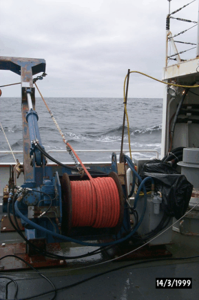
Figure 17. The J-frame with the Greene Bomber deployed on R/V ENDEAVOR 320. Note the way the towing line is lead through two blocks on the J-frame to enable the towed body to be picked up from the aft block and still be able to wind the cable onto the winch which lines up with the forward block. Also note that carabineers were used to keep the electrical cable “attached” to the towing line.
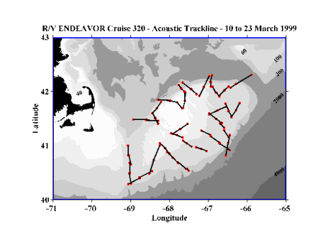 Figure 18.
Trackline segments along which high frequency acoustic data
were collected between broad-scale stations on R/V ENDEAVOR cruise
320. The closed circles mark the beginning or ending of a trackline
segment.
Figure 18.
Trackline segments along which high frequency acoustic data
were collected between broad-scale stations on R/V ENDEAVOR cruise
320. The closed circles mark the beginning or ending of a trackline
segment. 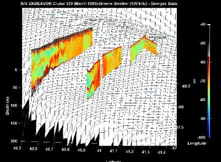
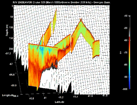
Figure 19. (Top) Acoustic sections taken on the southern flank of Georges Bank from Stations 4 to 6 (most westerly) and Stations 8 to 12 (most easterly). Note the strong mid-depth acoustic layer running from the shelf break to the acoustically well-mixed zone. (Bottom) Acoustic sections taken further to the east running from Stations 13 to 16 (partially hidden) and from 16 to 20. Again note the strong mid-depth layer which runs about a third of the way towards the crest of the Bank before it intersects the well-mixed zone. Also present at the shelf break was a large very dense aggregation of very strong acoustic scatterers. We postulate that this was a substantial gadoid fish school.
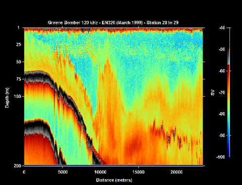
Figure 20. A short portion of the acoustic section running between Stations 28 (Northeast Peak) and 29 (Georges Basin) illustrating what appears to be a large lee-wave (the layer which runs along the bottom topography and then swoops up to near the surface). In this section further out into Georges Basin, small dense patches of scatterers occurred in a zone centered about 140 meters. These patches may have been herring schools. R/V ENDEAVOR 320 (March 1999).
Table III. Data Acquisition Log for R/V ENDEAVOR - GLOBEC Cruise 320 |
|||||||||
HTI-244 Echosounder running 120 and 420 kHz Tranducers, config file al9901.cfg |
|||||||||
Sta/Leg |
Date YR/YD |
DAT Tape # |
Start DAT |
Stop DAT |
Acoustic File |
Start ESS |
End ESS |
ESS File Name |
Comments |
dock |
99069 |
|
|
|
|
|
|
|
Diptest at dock; conductivity tube on. |
1-2 |
99070 |
1 |
1156 |
1305 |
W0701143 |
115? |
1601 |
gb00001 |
Deploy Greene Bomber; sample duration 0.5 minutes |
1-2 |
99070 |
|
|
|
end 1601 |
|
|
|
1208 Coming up to 7 knots; record clear, surface turb. |
bongo |
99070 |
2 |
1305 |
15?? |
|
|
|
|
Tape 2 |
2 |
99070 |
3 |
1753 |
2000 |
W0701751 |
1751 |
0753 |
gb00002 |
?when started? 070.744155 17:51:34 071.328646 7:53:15 |
|
99070 |
4 |
2000 |
2208 |
|
|
|
|
Tape 4; nearly to Bongo |
|
99070 |
5 |
2208 |
0015 |
W0702358 |
|
|
|
|
3 |
99071 |
6 |
0015 |
0221 |
|
|
|
|
New Acoustics file STATION 3 |
|
99071 |
7 |
0223 |
0430 |
W0710429 |
|
|
|
|
|
99071 |
8 |
0430 |
0637 |
|
|
|
|
|
|
99071 |
9 |
0637 |
0844 |
|
0758 |
1717 |
gb0003 |
SHUT DOWN to work on Fish at start of Station 4 |
|
99071 |
10 |
0845 |
(1053) |
|
|
|
|
missed 10 minutes of record. |
|
99071 |
11 |
1102 |
1307 |
|
|
|
|
|
|
99071 |
12 |
1308 |
1516 |
W0711319 |
|
|
|
|
|
99071 |
13 |
1638 |
1747 |
end 1717 |
1746 |
0215 |
gb0004 |
NO TIMER missed 1 hour 20 min. |
4 |
99071 |
14 |
1747 |
1955 |
W0711746 |
|
|
|
GB out for tow line check and taping of chewed data cable |
4 |
99071 |
15 |
2001 |
2209 |
|
|
|
|
6 minutes late; launch of Moc-1 delayed a bie |
4-5 |
99071 |
16 |
2210 |
0016 |
W0712222 |
|
|
|
SWITCH to C drive; 55 MB left on D c:\hti_dep\en320 |
4-5 |
99072 |
17 |
0016 |
0224 |
|
|
|
|
end at end of STATION 5 (ESS and Acoustics) |
5 |
99072 |
18 |
0224 |
0431 |
W0720222 |
|
|
|
|
5-6 |
99072 |
19 |
0432 |
(0640) |
|
|
|
|
missed tape change by a few minutes (15) |
6 |
99072 |
20 |
0655 |
0902 |
W0720654 |
|
|
|
|
6-7 |
99072 |
21 |
0903 |
1110 |
|
|
|
|
|
6-7 |
99072 |
22 |
1110 |
1259 |
W0711150 |
|
|
|
Bomber out 1259 (station 7); due for pit stop and conductivity check. |
8 |
99073 |
23 |
0804 |
1013 |
W0730803 |
0803 |
1306 |
gb00006 |
Bomber back in at start of Station 8 (long wait...) |
8-9 |
99073 |
24 |
1013 |
1219 |
end 1637 |
|
|
|
|
9 |
99073 |
25 |
1220 |
1427 |
|
|
|
|
Just arrived on Station 9 |
9 |
99073 |
26 |
1428 |
1635 |
|
1315 |
|
gb00007 |
Found Salinity problem in constants for probe– FIXED S |
9-10 |
99073 |
27 |
1636 |
1837 |
W0731637 |
|
|
|
|
10 |
99073 |
28 |
1837 |
2046 |
|
|
|
|
HTI quit– invalid calibration file |
10-11 |
99073 |
29 |
2046 |
2253 |
W0732052 |
|
|
|
c:\hit_dep\al9901_config.cfg RESTART and SAVE after bongo– GPS lost, start on com2, but not saved yet...2055 |
11-12 |
99073 |
30 |
2255 |
0102 |
end 0232 |
|
|
|
missed 2 minutes- doing moc-1 |
11-12 |
99074 |
31 |
0103 |
0309 |
W0740233 |
0235 |
0829 |
gb00008 |
Started new files at Station 12 |
12 |
99074 |
32 |
0310 |
0516 |
end 0353 |
|
|
|
problem with GPS not recording properly– tunred off machine and rebooted– tough go– had to reboot a couple of times and turn com GPS off and on before it would begin to acquire data |
12 |
99074 |
33 |
0517 |
0744 |
W0740410 |
|
|
|
missed tape change by 20 minutes or so |
12-13 |
99074 |
34 |
0745 |
0828 |
end 0829 |
|
|
|
stopped DAT tape- to hove to wait for storm to pass |
13 |
99076 |
35 |
0856 |
1104 |
W0760855 |
0855 |
1619 |
gb00009 |
RESTART after STORM; ducers off at start |
13-14 |
99076 |
36 |
1104 |
1310 |
|
|
|
|
|
14-16 |
99076 |
37 |
1311 |
1518 |
|
|
|
|
STATION 15 DROPPED; Bongo instead |
14-16 |
99076 |
38 |
1518 |
1725 |
W0761618 |
1621 |
0109 |
gb00010 |
after midway bongo tape change; started at STATION 16 |
16 |
99076 |
39 |
1725 |
1933 |
|
|
|
|
|
16 |
99076 |
40 |
1933 |
2141 |
|
|
|
|
|
16 |
99076 |
41 |
2141 |
2349 |
|
|
|
|
|
16 |
99076 |
42 |
2349 |
0153 |
W0770109 |
0111 |
|
gb00011 |
NEW TAPES SHORTER; missed real end by 3 minutes? Started new acoustics and ESS at end of station (moc-1) |
16-17 |
99077 |
43 |
0153 |
0356 |
|
|
|
|
Tape out by the time timer started chirping |
16-17 |
99077 |
44 |
0357 |
0559 |
|
|
|
|
|
17 |
99077 |
45 |
0600 |
0819 |
|
|
|
|
watch change– missed change by 15 minutes. |
17-18 |
99077 |
46 |
0819 |
1018 |
W0770821 |
|
0942 |
gb00012 |
missed 15 min of tape– no timer |
18 |
99077 |
47 |
1019 |
1220 |
|
|
|
|
DAT tape left running while FISH out |
18-19 |
99077 |
48 |
1221 |
1423 |
W0771054 |
1054 |
1621 |
gb00013 |
RESTART after PULL FISH for service and checking Station 18 |
18-19 |
99077 |
49 |
1424 |
1625 |
|
|
|
|
|
19 |
99077 |
50 |
1625 |
1828 |
W0771628 |
1628 |
0223 |
gb00014 |
ended at start of station 21 |
19-20 |
99077 |
51 |
1821 |
2031 |
|
|
|
|
|
19-20 |
99077 |
52 |
2031 |
2234 |
|
|
|
|
|
20 |
99077 |
53 |
2234 |
0036 |
W0780037 |
|
|
|
started sometime after Station 20 |
20-21 |
99077 |
54 |
0037 |
0238 |
end 0816 |
0225 |
0816 |
gb00015 |
started at start of Station 21 |
21 |
99078 |
55 |
0239 |
0440 |
|
|
|
|
|
21-23 |
99078 |
56 |
0440 |
0642 |
|
|
|
|
|
23 |
99078 |
57 |
0642 |
0817 |
|
1043 |
|
gb00016 |
PULL FISH TO STEAM TO STATION 29 |
39 |
99078 |
58 |
1043 |
1245 |
W0781043 |
|
|
|
|
39 |
99078 |
59 |
1246 |
1314 |
|
|
|
|
1314 SHUTDOWN |
25 |
99078 |
60 |
1429 |
1625 |
W0781429 |
1429 |
2009 |
gb00017 |
Start at STATION 25 again |
25 |
99078 |
61 |
1635 |
1834 |
|
|
|
|
|
25-26 |
99078 |
62 |
1835 |
2040 |
W0782009 |
2009 |
0859 |
gb00018 |
missed 5 min. ESS accidentally hit cntrl key and restarted both files at Bongo |
25-26 |
99078 |
63 |
2040 |
2242 |
end0053 |
|
|
|
|
26 |
99078 |
64 |
2243 |
0045 |
|
|
|
|
|
26-27 |
99079 |
65 |
0046 |
0247 |
W0790053 |
|
|
|
DAT change at halfway Bongo station |
27 |
99079 |
66 |
0247 |
0449 |
end 0859 |
|
|
|
Dat started after CTD on board; STA 27 |
27-28 |
99079 |
67 |
0449 |
0756 |
|
|
|
|
Dat changed btwn Sta 27 and bongo; lost 30 minutes |
28-29 |
99079 |
68 |
0758 |
0959 |
W0790900 |
0900 |
1524 |
gb00019 |
tape started late; end at end of STA 29 Moc-1 tow |
29 |
99079 |
69 |
1000 |
1202 |
end 1524 |
|
|
|
|
29 |
99079 |
70 |
1203 |
1406 |
|
|
|
|
|
29 |
99079 |
71 |
1406 |
1608 |
W0791524 |
1526 |
1159 |
gb00020 |
at Station 29 still– started at end of Sta 29 Moc (ESS and acoustics) |
29-30 |
99079 |
72 |
1608 |
1810 |
|
|
|
|
|
29-30 |
99079 |
73 |
1810 |
2012 |
|
|
|
|
missed 12 minutes doing moc-1 |
30 |
99079 |
74 |
2024 |
2227 |
|
|
|
|
|
40 |
99079 |
75 |
2227 |
0029 |
W0800001 |
0001 |
0801 |
gb00021 |
Station 40 |
40 |
99080 |
76 |
0030 |
0232 |
end 0436 |
|
|
|
Tape change at 40 |
40 |
99080 |
77 |
0232 |
0434 |
|
|
|
|
End of Moc-1 tow |
40-331 |
99080 |
78 |
0435 |
0637 |
W0800436 |
|
|
|
Start of Station 31; new file and tape |
31-32 |
99080 |
79 |
0638 |
0842 |
|
0802 |
0108 |
gb00022 |
Dat change underway; Start ESS at Station 32 Moc-1 |
32-33 |
99080 |
80 |
0842 |
1043 |
|
|
|
|
|
32-33 |
99080 |
81 |
1044 |
1247 |
W0801227 |
|
|
|
|
33-34 |
99080 |
82 |
1248 |
1450 |
end 1602 |
|
|
|
|
34 |
99080 |
83 |
1450 |
1752? |
|
|
|
|
NO IDEA WHAT HAPPENED HERE ...missed an hour |
34 |
99080 |
84 |
1751 |
1953 |
W0801602 |
|
|
|
|
34-35 |
99080 |
85 |
1953 |
2101 |
end 0053 |
|
|
|
|
35-36 |
99080 |
86 |
2101 |
2301 |
|
|
|
|
|
35-36 |
99080 |
87 |
2301 |
0103 |
W0810053 |
0110 |
0634 |
gb00023 |
Changed acoustics on run between 36 and 38 (skip 37 due to weather) |
36-38 |
99081 |
88 |
0104 |
0305 |
end 0634 |
|
|
|
DAT tape change after bongo by 15 minutes or so |
36-38 |
99081 |
89 |
0306 |
0508 |
|
|
|
|
Lost a couple of hours of GB data NO TAPE in DAT. |