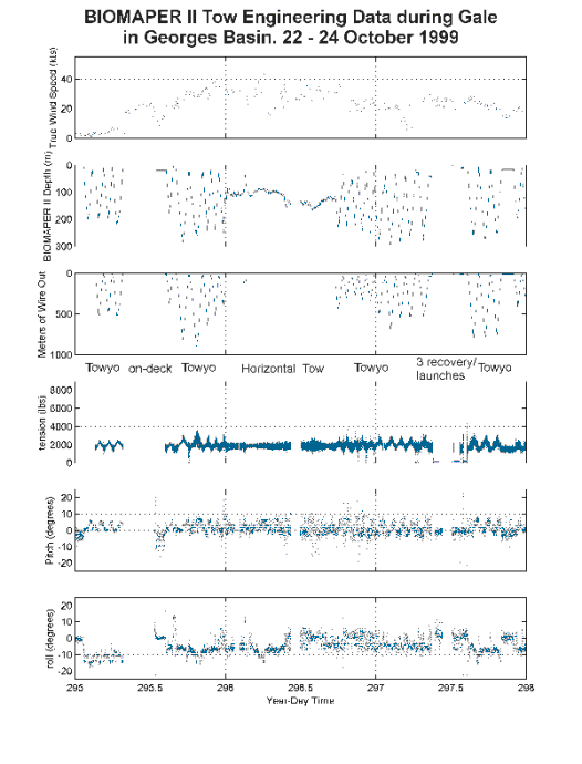
 Figure 5. BIOMAPER II tow engineering data collected during a gale in Georges
Basin, 22-24 October 1999. Wind speed data were collected at 1 minute intervals;
wire tension and line out data were collected at 0.25 second intervals; BIOMAPER II
depth, roll, and pitch data were collected at 4 second intervals.
Figure 5. BIOMAPER II tow engineering data collected during a gale in Georges
Basin, 22-24 October 1999. Wind speed data were collected at 1 minute intervals;
wire tension and line out data were collected at 0.25 second intervals; BIOMAPER II
depth, roll, and pitch data were collected at 4 second intervals.
 Figure 6. Wire tension data and power spectra from sections of the data
collected during the period 22-24 October 1999. A) Towyo during light
winds in Jordan Basin. B) Towyo with increasing wind at the start of
work in Georges Basin. C) Horizontal tow during high sustained winds
in Georges Basin. D) Continuation of horizontal tow in high sustained
winds. E) Resumption of towyos with decreasing winds. F) Towyo
during sustained moderate winds. G) Towyo during sustained moderate
winds after BIOMAPER II VPR repair. The dotted vertical lines in the
power spectra plots mark the approximate position of the towyo
frequency and the positions of the 5-second and 10-second frequencies
that typically bracket the ship’s roll and pitch motion.
Figure 6. Wire tension data and power spectra from sections of the data
collected during the period 22-24 October 1999. A) Towyo during light
winds in Jordan Basin. B) Towyo with increasing wind at the start of
work in Georges Basin. C) Horizontal tow during high sustained winds
in Georges Basin. D) Continuation of horizontal tow in high sustained
winds. E) Resumption of towyos with decreasing winds. F) Towyo
during sustained moderate winds. G) Towyo during sustained moderate
winds after BIOMAPER II VPR repair. The dotted vertical lines in the
power spectra plots mark the approximate position of the towyo
frequency and the positions of the 5-second and 10-second frequencies
that typically bracket the ship’s roll and pitch motion.