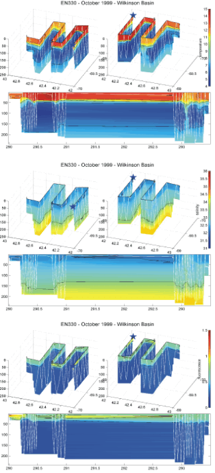
 Figure 7. 3D (latitude, longitude, and depth) and time/depth
plots of BIOMAPER II Temperature (C), salinity (PSU), and
fluorescence (Volts) from Wilkinson Basin collected on R/V
ENDEAVOR Cruise 330. The star marks the start of the
trackline; the white lines mark the towyo path of
BIOMAPER II.
Figure 7. 3D (latitude, longitude, and depth) and time/depth
plots of BIOMAPER II Temperature (C), salinity (PSU), and
fluorescence (Volts) from Wilkinson Basin collected on R/V
ENDEAVOR Cruise 330. The star marks the start of the
trackline; the white lines mark the towyo path of
BIOMAPER II.
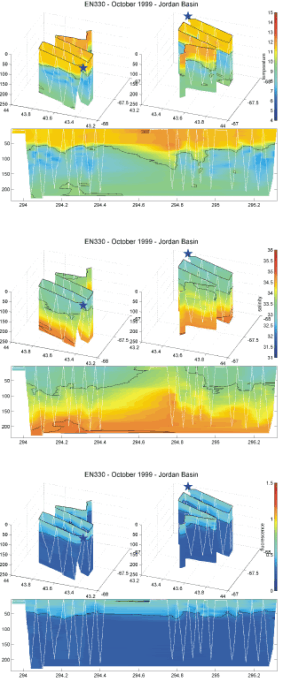 Figure 8. 3D (latitude, longitude, and depth) and
time/depth plots of BIOMAPER II Temperature (C),
salinity (PSU), and fluorescence (Volts) from Jordan
Basin collected on R/V ENDEAVOR Cruise 330. The
star marks the start of the trackline; the white lines
mark the towyo path of BIOMAPER II.
Figure 8. 3D (latitude, longitude, and depth) and
time/depth plots of BIOMAPER II Temperature (C),
salinity (PSU), and fluorescence (Volts) from Jordan
Basin collected on R/V ENDEAVOR Cruise 330. The
star marks the start of the trackline; the white lines
mark the towyo path of BIOMAPER II.
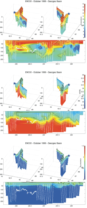 Figure 9. 3D (latitude, longitude, and depth) and
time/depth plots of BIOMAPER II Temperature (C),
salinity (PSU), and fluorescence (Volts) from Georges
Basin collected on R/V ENDEAVOR Cruise 330. The
star marks the start of the trackline; the white lines mark
the towyo path of BIOMAPER II.
Figure 9. 3D (latitude, longitude, and depth) and
time/depth plots of BIOMAPER II Temperature (C),
salinity (PSU), and fluorescence (Volts) from Georges
Basin collected on R/V ENDEAVOR Cruise 330. The
star marks the start of the trackline; the white lines mark
the towyo path of BIOMAPER II.