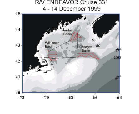
Figure 1. Cruise track, EN331.
We would like to thank the captain and crew of the R/V ENDEAVOR for a productive cruise; their professionalism was greatly appreciated. We also thank the US GLOBEC Georges Bank Program for supporting this cruise, with research support provided by NOAA. Support for the bio-optical oceanographic research conducted on this cruise was provided by an award from the ONR Young Investigator Program.
1.0 INTRODUCTION
2.0 CRUISE NARRATIVE
3.0 INDIVIDUAL REPORTS
3.1 Principal Project: Processes Regulating the Recruitment of Calanus finmarchicus
3.1.1 Introduction.
3.1.2 Methods
3.1.2.1 Broad-scale survey
3.1.2.2 Zooplankton characterization from MOCNESS samples
3.1.3 Results
3.1.3.1 Broad-scale survey
3.1.3.1.1 Multi-frequency acoustics and Environmental Sensing System (ESS)
3.1.3.2 Zooplankton characterization from MOCNESS samples
3.2 Ancillary Project: Spatio-Temporal Variability of Bio-Optical Properties in the Gulf of Maine
3.2.1 Introduction
3.2.2 Methods
3.2.3 Preliminary Results
4.0 CRUISE PARTICIPANTS 16
4.1 Scientific personnel
4.2 Ship's officers and crew
Appendix I. R/V/ ENDEAVOR Cruise 331 Event Log.
Appendix II. R/V ENDEAVOR Cruise 331 Acoustic Log.
Appendix III. R/V ENDEAVOR Cruise 331 VPR Log.
Appendix IV. R/V ENDEAVOR Cruise 331 "All" Tapes Cross_comparison Log.
Appendix V. R/V/ ENDEAVOR Cruise 331 MOCNESS Zooplankton Log.
Appendix VI. R/V/ ENDEAVOR Cruise 331 Scatterometer Log.
R/V ENDEAVOR cruise 331 was conducted as a U.S. GLOBEC process cruise to examine late autumn conditions in the
Gulf of Maine relevant to ecosystem processes on Georges Bank. The major scientific objectives of the cruise included:
Summaries of the two primary projects supported by this cruise are presented in the sections following the cruise narrative.
R/V ENDEAVOR cruise 331 was planned as a broad-scale, bio-optical, and bioacoustical survey cruise traversing the major basins of the Gulf of Maine. We had weather-based contingency plans for conducting this survey cruise in either a clockwise manner (Wilkinson Basin - Jordan Basin - Georges Basin) or the reverse. A grid of regularly spaced transect lines was laid out for the survey of each basin. In addition to the survey itself, time was allocated for daytime and nighttime MOCNESS tows as well as mid-day light stations.
The R/V ENDEAVOR departed Woods Hole on cruise EN-331 at 6:30 on 4 December 1999. Departure was delayed one day while we waited for R/V Oceanus to depart port and make space available for R/V ENDEAVOR to load. Under sunny skies and light winds, we set out for Wilkinson Basin in the Gulf of Maine. A chart of the cruise track for EN-331 provides an outline for the work described in this cruise report (Figure 1 - Appendix I). The meteorological conditions that occurred on this cruise ranged from ideal (i.e. virtually no wind and calm seas) to winter storm conditions (i.e. 50 knot winds and 3 - 4 m seas (Figure 2).
Figure 1. Cruise track, EN331.
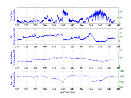
Figure 2. Meteorological conditions during EN331.
We arrived at our first site in Wilkinson Basin and deployed the BIOMAPER-II at 14:15 (BMP 1). After all systems were checked, we conducted a daytime MOCNESS tow (MOC 1) from 15:07 to 16:31. After the MOCNESS tow, we began towyoing in Wilkinson Basin along the first west-east transect line (1WBWE). Three towyos (1WBWE1-3) were conducted along this line, although the third was completed as the first towyo on the next transect line (2WBSN1). One additional towyo (2WBSN2) was completed along this line. After this transect line was completed, we conducted a nighttime MOCNESS tow (MOC 2) from 22:58 to 0002 on 5 December. Towyoing resumed after the MOCNESS tow, and we completed three towyos along an east - west transect line (3WBEW1-3), one towyo along a south - north transect line (4WBSN1), and four towyos along a west - east transect line (5WBWE1-4) before reaching the first mid-day light station.
At 11:57, we began the first mid-day light station activities. The BIOMAPER-II was recovered to service an AC-9 during the light station activities. These activities included deployment of a tethered, free-fall vertical Satlantic profiling multi-channel radiometer (SPMR 1) and a CTD/Niskin bottle rosette (CTD 1). The SPMR profile was collected successfully; however, the CTD required two casts before a profile was collected successfully. The light station activities were completed by 14:45.
The BIOMAPER-II was redeployed at 15:11 (BMP 2), and we began towyoing again. Two towyos along a south - north transect line (6WBSN1,2), three towyos along an east - west transect line (7WBEW1-3), and two towyos along a south - north transect line (8WBSN1,2) were completed before the final nighttime MOCNESS tow (MOC 3) in Wilkinson Basin was conducted from 00:37 to 01:58 on 6 December. The BIOMAPER-II was recovered at 02:02, and we began the transit to Jordan Basin.
The BIOMAPER-II was deployed in Jordan Basin at 12:16 (BMP3) and towed near the surface as we conducted a daytime MOCNESS tow and mid-day light station. The MOCNESS (MOC 4) was conducted from 12:13 to 13:30. The mid-day light station activities began at 13:42. These activities included deployment of a tethered, free-fall vertical Satlantic profiling multi-channel radiometer (SPMR 2) and a CTD/Niskin bottle rosette (CTD 2). The light station activities were completed by 15:04.
At 15:15, we began towyoing again. Five towyos along a south - north transect line (1JBSN1-5) were completed before a nighttime MOCNESS tow (MOC 5) was conducted from 21:55 to 22:54. Towyoing resumed after the MOCNESS tow, and we completed one towyo along a west - east transect line (2JBWE1), four towyos along a north - south transect line (3JBNS1-4), one towyo along a west - east transect line (4JBWE1), and four towyos along a south - north transect line (5JBSN1-4) before stopping at 12:34 on 7 December to conduct a CTD cast (CTD 3). After the CTD cast, we began towyoing again at 13:06. Three north - south towyos and one west - east towyo were conducted before we recovered the BIOMAPER-II at 18:05 for the transit to Georges Basin. A winter storm moved in at this time, and delayed our departure until the next morning at 08:00 (8 December).
The BIOMAPER-II was deployed in Georges Basin at 18:39 (BMP4). One towyo was completed along a west - east transect line (1GBWE1), but the video plankton recorder (VPR) only worked intermittently at depths greater than 250 m. The BIOMAPER-II was recovered at 20:50 to check all cables and connectors. No obvious problems were discovered, so we redeployed the BIOMAPER-II (BMP 5) at 21:28 and decided to not exceed 250 m during towyos. A nighttime MOCNESS tow (MOC 6) was conducted from 21:38 to 23:14. Towyoing resumed after the MOCNESS tow, and we completed five more towyos along the west - east transect line in Georges Basin (1GBWE2-6) and five towyos along a north - south transect line in Northeast Channel (1NECNS1-5). We reached the end of the second line at 12:35 on 9 December and stopped to conduct a mid-day light station and daytime MOCNESS tow.
The mid-day light station activities began at 12:46. These activities included deployment of a tethered, free-fall vertical Satlantic profiling multi-channel radiometer (SPMR 3) and a CTD/Niskin bottle rosette (CTD 4). The light station activities were completed by 14:13. The daytime MOCNESS tow (MOC7) was conducted from 14:15 to 15:27.
After the MOCNESS tow, we began towyoing again at 16:04. Three south - north towyos in Northeast Channel (2NECSN1-3) and two east -west towyos in Georges Basin (2GBEW1,2) were conducted before we stopped for a nighttime MOCNESS tow. The MOCNESS tow (MOC 8) was conducted from 22:47 to 00:21 on 10 December. After the MOCNESS tow, we resumed towyoing. Five more towyos in Georges Basin (2GBEW3-7) were conducted before we recovered the BIOMAPER-II at 08:38 on 10 December. With the BIOMAPER-II aboard, we steamed for cover behind Cape Cod to avoid the worst of an approaching winter storm. During the steam to the Cape, we stopped at a station in the Gulf of Maine, between Franklin and Wilkinson Basins, to conduct a mid-day light station. The mid-day light station activities began at 12:24. These activities included deployment of a tethered, free-fall vertical Satlantic profiling multi-channel radiometer (SPMR 4) and a CTD/Niskin bottle rosette (CTD 5). The light station activities were completed by 13:40.
Strong winds, approaching 50 knots, prevented us from working outside the protection of the Cape on 11 December. Therefore, we conducted a BIOMAPER-II deployment (BMP 6) and recovery drill in mid-afternoon to videotape the handling system's performance. This drill went well, and we have good video footage to share with interested parties.
We remained behind Cape Cod until conditions improved during the late morning of 12 December. At that point, we steamed out into Massachusetts Bay to conduct a mid-day light station. The BIOMAPER-II was deployed (BMP 7), and we conducted a shallow towyo prior to the light station. The light station activities began at 11:19. These activities included deployment of a tethered, free-fall vertical Satlantic profiling multi-channel radiometer (SPMR 5) and a CTD/Niskin bottle rosette (CTD 6). The light station activities were completed by 12:50, and another shallow towyo was conducted. Afterwards, the BIOMAPER-II was recovered at 14:37.
As conditions continued to improve, we took advantage of our extra time and steamed out into Wilkinson Basin to perform several experiments. The first experiment, designed by Peter Wiebe, involved towing the BIOMAPER-II horizontally for 6-min intervals at a series of depths 25 m apart. This experiment was designed to help us determine the source of acoustic backscattering enhancement or suppression associated with towyoing the BIOMAPER-II through different portions of the water column. The second experiment, designed by Mark Benfield, involved simultaneously towyoing the BIOMAPER-II and MOCNESS between 20 m and 30 m. A related, third experiment, designed by Mark Benfield, involved simultaneously towing the BIOMAPER-II and MOCNESS for 6-minute intervals at a series of depths 2 m apart between 30 m and 14 m. Both experiments were designed to intercompare acoustic, VPR, and net sampling methods for estimating zooplankton distribution and abundance.
When we reached an appropriate starting position, the BIOMAPER-II was deployed (BMP 8) at 16:40. The first Benfield experiment was conducted from17:01 to 18:06 and included the ninth MOCNESS deployment (MOC 9). The Wiebe experiment was conducted between 18:15 and 21:00. The second Benfield experiment was conducted from 21:06 to 23:01 and included the tenth MOCNESS deployment (MOC 10). After these experiments were completed, we recovered the MOCNESS and BIOMAPER-II and began the steam to Woods Hole.
We arrived in Woods Hole at about 14:30 on 13 December 1999.
3.1 Principal Project: Processes Regulating the Recruitment of Calanus finmarchicus from the Gulf of Maine to Georges Bank.
Principal Investigators: C.H. Greene (Cornell), M.C. Benfield (LSU), P.H. Wiebe (WHOI).
3.1.1 Introduction.
Calanus finmarchicus dominates zooplankton secondary production on Georges Bank during spring. The Georges Bank Calanus population is derived from diapausing populations in the deep basins of the Gulf of Maine, the Slope Water, and the Scotian Shelf east of the Bank. It is hypothesized that processes that regulate the survivorship and supply of Calanus from diapausing populations in the deep basins of the Gulf of Maine determine this copepod species' annual production on Georges Bank. To test this hypothesis, research is being conducted 1) to determine what processes regulate the abundance and survivorship of the diapausing Calanus populations in these deep basins, and 2) to determine how physical and biological processes interact to seed Georges Bank with recruits from these basins each year.
Acoustic and video remote-sensing methods were used to survey diapausing populations of Calanus in Georges, Jordan, and Wilkinson Basins of the Gulf of Maine. Broad-scale survey cruises conducted in early and late autumn
during 1998 and 1999 will be used to estimate survivorship of the diapausing Calanus and the scale-dependent spatial coupling of Calanus and its principal invertebrate predators - the euphausiid, Meganyctiphanes norvegica, and the siphonophore, Nanomia cara.
Results from field studies will focus on quantifying the relative contribution of predation to the overall mortality of the diapausing Calanus population. The results from field studies also will be used as input to coupled physical-biological models to examine how physical transport processes in the Gulf of Maine interact with Calanus' seasonal and diel vertical migration behaviors to seed Georges Bank with new recruits during winter.
3.1.2 Methods
3.1.2.1 Broad-scale survey
A broad-scale survey of the Gulf of Maine deep basins was conducted from December 4-13, 1999. The survey track included multiple transect lines in Wilkinson, Jordan, and Georges Basins (Figure 1). The survey was conducted
using a high-speed, deep-towed system, the BIOMAPER-II, configured with multiple-frequency (43 kHz, 120 kHz, 200 kHz, 420 kHz, and 1 MHz) acoustics, a video plankton recorder (VPR), and several bio-optical sensors (down- and upwelling spectral radiometers, spectrally matched attenuation, scattering, and absorption meters). The acoustic frequencies were chosen to bracket the transition from the Rayleigh to geometric scattering regions for the target species under investigation. A down- and up-looking transducer operated at each frequency to provide more complete coverage of the water column when the instrument was towyoed. Echo integration was conducted at 12-second intervals to provide volume-backscattering data at all five frequencies. Split-beam data were collected at the four lower frequencies. All raw acoustic data were recorded on digital audio tape, while the processing for echo integration was carried out in real time (Appendix II).
The software to acquire the data, which was provided by HTI, enabled the simultaneous acquisition of data on five frequencies each with two transducers (one up-looking and one down-looking). The range of the 0.5 meter depth strata allocated for each transducer was dependent on frequency with the lowest frequencies given the longest range and highest frequency the shortest range i.e. 43 kHz = 200 m, 120 kHz = 200 m, 200 kHz = 149 m, 420 kHz = 100 m, 1000 kHz = 35 m). A ping cycle for all frequencies and transducers took about 2.5 seconds with a firing sequence of down-looking 43, 120, 200, 420, 1000 kHz and then up-looking 43, 120, 200, 420, 1000 kHz. Target strength measurements were also collected on the lower 4 frequencies out to 20 meters from the surface of the split beam transducers. In addition, the raw data for each ping were recorded on DAT tape for post-processing of either target strengths or echo-integrations on a different time averaging basis. Each tape recorded two gigabytes of data and a total of 58 tapes were recorded during the cruise.
Post-processing software was used to combine the up-looking and down-looking data for a given frequency, and then the data were displayed in a color-enhanced echogram. On this cruise, a MATLAB version of the program to translate HTI-DES formatted acoustic data to a MATLAB compatible format (the Wiebe format) was used by Joe Warren to post-process the acoustic data.
The VPR mounted on BIOMAPER-II sampled a volume of 41.7 liters min-1. All video images were recorded on SVHS tape for post-cruise processing, while real-time processing enabled us to capture in-focus images to hard disk (Appendix III). GPS data were synchronized with the VPR signal and stamped on the video time code. Our at-sea image-processing was designed to provide a qualitative estimate of the distribution of different taxa in the sense that we had not verified the extraction efficiencies of our program settings. The constantly updating regions of interest (ROIs) that appeared on our computer monitor gave us some ground-truthing information along the cruise track. Quantitative ground-truthing will have to wait until the data are post-processed on shore using verified extraction settings.
Cross-referencing information was prepared at the end of the cruise for the various logged data sets (Appendix IV).
This was the second cruise on which BIOMAPER-II was deployed, towed, and recovered using the unique, self-contained handling system newly-built by Dynacon, Inc. specifically for BIOMAPER-II, with funding from DURIP. Powered and controlled electrically and driven hydraulically, it was first used on ENDEAVOR Cruise 330 in October 1999. The system consists of a winch and electro-optical cable, slack tensioner, J-frame/docking mechanism, power pack/hydraulic system, and local and remote controls (See the report for ENDEAVOR Cruise 330 for more details of its construction and use). The slack tensioner is a coupled hydraulic and nitrogen gas compensated system. Currently we have separate high (450 psi) and low (350 psi) pressure manifolds connected to same pressure N2 tanks, separated by valves into the accumulator cylinder. During the cruise, A. Girard logged wire tension, accumulator tank pressure, and piston extension distance of the Dynacon slack/tensioning system. Wire tension and line payout were recorded from the winch control console. Accumulator tank pressure was read from the gauge on one of the two open manifolds above the bank of nitrogen tanks. The piston extension distance was measured from the shoulder of cylinder to the bottom of the mount on top of the piston using a tape measure. Most of the measurements were recorded during flat calm seas. During these times there was little movement in the slack/tensioner. The manual logging was tedious, slow, and subject to error. An automated recording system would overcome these problems. These recordings provided baseline data on which showed the pressure response to increased wire tension as the cable was paid out to a maximum of 800 m during towyos of BIOMAPER-II. The purpose of having two banks of tanks, one with high pressure and one with lower pressure, was to be able to switch between the two enable better compensation near the surface when tension is lower (lower pressure bank) and at depth when the tension is higher (high pressure bank). However, this must now be done manually and for several reasons does not work very well. As a result, we tuned the compensation system so that it functioned best when BIOMAPER-II was at the surface. A fully automated dynamic pressure compensation system is needed to handle the dynamic range of tensions experienced by BIOMAPER-II as it is towyoed between 0 and 300 m depth. The handling system as a whole worked very well for the duration of the cruise.
3.1.2.2 Zooplankton characterization from MOCNESS samples
During the broad-scale survey cruise of the Gulf of Maine deep basins, MOCNESS tows were conducted at three stations in Wilkinson Basin, two stations in Jordan Basin, and three stations in Georges Basin, one of which was in the Northeast Channel (Table 1).
Table 1. MOCNESS tow data.
| Tow # | Date | Time In | Lat(N) | Lon(W) | Time Out | Lat(N) | Lon(W) | Sunrise (local time) | Sunset |
| M-01-001 | 04 Dec 1999 | 338.629861 | 42.0823 | -069.6970 | 338.688194 | 42.0845 | -069.6418 | 0650 | 1608 |
| M-01-002 | 04 Dec 1999 | 338.998611 | 42.2687 | -069.3062 | 339.001389 | 42.2637 | -069.3500 | 0643 | 1606 |
| M-01-003 | 06 Dec 1999 | 340.025694 | 42.7248 | -069.8373 | 340.123611 | 42.6711 | -069.8475 | 0654 | 1606 |
| M-01-004 | 06 Dec 1999 | 340.514583 | 43.3174 | -068.0000 | 340.562500 | 43.2828 | -068.0142 | 0649 | 1557 |
| M-01-005 | 06 Dec 1999 | 340.954861 | 43.8303 | -067.7225 | 340.999306 | 43.8012 | -067.7045 | 0650 | 1554 |
| M-01-006 | 08 Dec 1999 | 343.901389 | 42.4960 | -067.0767 | 343.968056 | 42.4917 | -067.0315 | 0647 | 1558 |
| M-01-007 | 09 Dec 1999 | 343.593750 | 42.1225 | -065.6850 | 343.643750 | 42.1300 | -065.7062 | 0639 | 1551 |
| M-01-008 | 09 Dec 1999 | 343.949306 | 42.4193 | -066.5690 | 344.014583 | 42.3880 | -066.6273 | 0643 | 1554 |
| M-01-009 | 12 Dec 1999 | 346.709028 | 42.2397 | -069.7793 | 346.754167 | 42.2732 | -69.7692 | 0657 | 1607 |
| M-01-010 | 12 Dec 1999 | 346.893056 | 42.1235 | -069.6418 | 346.959028 | 42.1000 | -69.6467 | 0657 | 1607 |
The MOCNESS samples were collected for ground-truthing and inter-comparisons between the acoustic and VPR data. Splits from the MOCNESS samples were preserved in formalin for quantitative studies and preserved in alcohol or frozen in liquid nitrogen for molecular studies of Calanus and Meganyctiphanes population genetics by Ann Bucklin (University of New Hampshire), diapause physiology by Patrick Hassett (University of Ohio) and Charles Miller (Oregon State University), and nitrogen stable isotope analysis by Karen Fisher (Cornell University).
All MOCNESS tows were conducted with ship speeds of 1.5 - 2.5 knots. The zero net was fished from the surface to within 10 m of the bottom where net 1 was opened. Sampling strata for nets 1 through 8 was dependent on water depth, generally, intervals of 25 m were sampled near the bottom and the surface, and remaining intervals ranged from 25 to 75 m. The down-cast (net 0) was fished at a wire speed of 15 m/minute, and the up-cast (nets 1-8) was hauled in at a speed of between 5 and 15 m/minute. From approximately 100 to 300 cubic meters of water were filtered for each of nets 1 through 8.
Samples were processed at sea in the following manner. The sample taken from net zero on all hauls was preserved in 95% ethanol for Ann Bucklin. Plankton samples from nets 1 through 8 were split with a box splitter. One-half split was preserved in 5-10% buffered formalin for silhouette analysis to ground-truth the acoustic and VPR data. The other half split was made up to 600 ml, and 100 ml were removed and preserved in 9% formalin for Charles Miller's life history studies. The remainder of the 600 ml was either sieved and spooned into ethanol for Ann Bucklin's genetic studies or placed into plastic bags and frozen for Patrick Hassett's diapause physiology studies. In addition, approximately 90 individual Meganyctiphanes specimens were picked out and frozen for Ann Bucklin's genetic studies of this species. Finally, one teaspoon was taken from each net from Haul 7 and frozen in liquid nitrogen for Karen Fisher's work.
3.1.3 Results
3.1.3.1 Broad-scale survey
3.1.3.1.1 Multi-frequency acoustics and Environmental Sensing System (ESS)
The multi-frequency acoustics, bio-optical (including VPR), and physical oceanographic data were collected during seven of eight deployments of BIOMAPER-II throughout the Gulf of Maine. The first deployment where data were collected was on the Southwestern end of Wilkinson Basin at 14:15 on 4 December. This data collection was ended 12:01 on 5 December to bring the vehicle on board to do a system check and to make sure nothing had come loose during the initial deployment. Three hours later, the vehicle was again deployed and the remainder of the trackline was completed about 0215 on 6 December. A total of about 147 nm of trackline were surveyed in Wilkinson Basin (Table 2).
The work in Jordan basin commenced about noon on 6 December with the third deployment of BIOMAPER-II and was completed without interruption about 30 hours later at 18:12 on 7 December just as a gale's full force came upon us. In spite of very rough seas and strong winds, bringing the fish on board was a piece of cake. Several of us (Jay, Charlie, Mari, Aaron, Fred) set up the air tugger lines on poles to get ready to snap hook the lines onto the fish once it was clear of the water. With the ship rolling some and pitching as it jogged into the sea at about 2 knots, Andy, on the controls, turned off the slack tensioner. He then hauled the wire in and the vehicle came up straight out of the water. The cable termination slid into the docking mechanism and the hook latched as it was designed to do. Immediately, he started the J-frame coming up and inboard. As BIOMAPER-II was lifted free of the water, several strong waves passed by raking the vehicle, but the docking mechanism held it secure and steady. Once clear of the water, the tugger lines were snap hooked onto the stainless steel side bars and pulled tight. Steadily, BIOMAPER-II came over the rail and once the frame was fully inboard, Andy pulled up on the cable, unlocked the latch and lowered BIOMAPER-II to the deck, all while the deck crew kept the tugger lines taut. The landing on the deck was smooth. The tugger lines were kept in place while the deck straps were put in place, holding BIOMAPER-II securely on the deck. The whole operation took only three or four minutes. A total of about 146 nm of trackline were surveyed in Jordan Basin.
With wind and seas finally abating, we steamed from Jordan Basin to Georges Basin arriving about 16:00. BIOMAPER-II was readied for deployment and the procedure started, but the hydraulics failed when the J-frame was engaged to boom-out. After a time-consuming set of checks, the problem, a hydraulic quick connect next to the control console had disconnected, was identified and fixed. A few minutes later BIOMAPER-II was in the water and starting the first towyo in Georges Basin about 18:39 on 8 December. It was brought on board a couple of hours later to check the VPR which quit working at a depth of about 289 m for a short period. The problem was not identified, but a 250 m depth limit for towyos was put in place to prevent a subsequent failure. The problem did not re-appear. The trackline, which included work out to the seaward entrance of the Northeast Channel, was completed at the western end of Georges Basin about 08:38 on 10 December. The work was actually cut short to allow time to run to Cape Cod Bay to avoid being in open water when an impending storm arrived in the area.
At about 13:00 on 11 December, while jogging into the seas during the height of the storm, we did a launch and recovery sequence in Cape Cod Bay with C. Greene taking digital movies of the sequence. The wind was howling and the seas were quite rough even though there was not much fetch in the bay. The sun was out from between the clouds and it was a very good day to demonstrate the performance of the BIOMAPER-II handling system. We shot scenes of the launch from several view points, then the action of the slack tensioner as the ship pitched into the sea, and finally, the recovery which went smoothly. Andy was on the controls and Charlie, Glenn, and Fred did most of the work with the lines and tuggers. All in all it went very well.
Table 2. Distance of BIOMAPER-II Trackline Sections on R/V ENDEAVOR Cruise 331 (4-13 December 1999)
| Area | km | nm |
|---|---|---|
| Wilkinson Basin | 272.3 | 147.0 |
| Jordan Basin | 270.7 | 146.1 |
| Georges Basin/NE Channel | 333.3 | 180.0 |
| Total | 876.3 | 473.1 |
On Sunday (12 December), with winds diminishing and the seas rough but workable nearshore, we steamed to Massachusetts Bay to conduct combined optical and BIOMAPER-II operations beginning about 11:19 and ending about 14:37. Then, with continued diminishing winds and seas, we headed east out to deeper water in Wilkinson Basin where we conducted three special experiments.
BIOMAPER-II was deployed during the last light of the day about 16:40. Shortly after, the MOCNESS was launched and M. Benfield led the first of two towyo experiments comparing the VPR with the MOCNESS. The first consisted of a series of saw-toothed up and down towing trajectories between 30 and 20 meters with both instrument systems. Net 0 was fished to 30 m, and then seven nets were towyod in tandem with BIOMPAPER II. The last net (#8) towed from 20 meters to the surface.
An acoustics experiment consisted of a series of horizontal tows separated by oblique sections starting from near the surface and working in 25 meter steps down to about 200 m depth and then back up to the surface with the ship steaming at between 4 and 6 knots. Each horizontal run was 6 minutes. This experiment was designed to provide acoustic data set that could be used to evaluate the source or cause of enhanced volume backscattering within about 15 to 18 m of BIOMAPER-II (beyond the near field of the transducers). The experiment started about 18:20 and ended about 21:00 and took about 2.5 hours to complete.
The second towyo experiment comparing the VPR with MOCNESS was started about 21:30. The first net (#0) was fished down to 120 meters to collect live animals for shore based experiments and then the first net was opened at 30m and held open there for 6 minutes. BIOMAPER-II was then raised 2 meters followed by the raising of MOCNESS one minute later and the next net opened and fished for six minutes. This sequence was carried out for seven nets. With the completion of this experiment about 22:53, the instrument systems were brought on board, and secured for the trip back to Woods Hole.
The instrument systems on BIOMAPER-II worked well on this cruise. There were minor problems, but none caused a lot of down time or loss of substantial amounts of data. We finished the cruise as we started it with all sensor systems working.
Hydrographic results.
Throughout the Gulf of Maine, the temperature and salinity showed significant changes between October and December. The changes in surface temperature in the region from 13 to 14 C in October to under 10 C in December can be explained by Air/Sea interactions and surface layer mixing. The hydrography changes observed in Wilkinson Basin at deeper depths between October and December appeared to take place in the vicinity of the deepest bathymetric channel between Jordan and Georges into Wilkinson Basin which are near the middle to more southerly end of the Basin. The biggest changes in temperature at depth took place in the vicinity of that channel. The deeper changes would seem to require an advective exchange. The surface waters of Jordan Basin were substantially colder than in October while the deeper intermediate waters appeared warmer, although there was still a minimum zone in this part of the water column in most, but not all parts of the Basin surveyed. The bottom water also appeared slightly warmer than in October. Salinities in the surface layers were higher than in October, but somewhat lower at depth. Fluorescence values were much lower than in October with little enhancement in the surface mixed layer.
In Wilkinson Basin, the surface layer (0 to ~80 m) had temperatures of between 8.5 and 9.2 C. There was a pronounced subsurface temperature minimum zone in the western and northern portions of the basin between 100 and 170 m with minimum temperatures ranging between 6.4 and 7 C. Near bottom temperatures increased to between 7.6 and 8 C. Salinities increased monotonically from 32.7 PSU at the surface to the bottom of the mixed layer until reaching maximum values about 34.2 PSU at the bottom of the basin (~ 250 m). But in the eastern side of the basin, the vertical temperature profile was substantially different with temperatures as warm as 9.5 C between 100 and 160 m and salinities in this portion of the water column were approximately 0.4 PSU higher than in the other areas. This water appeared to be entering the basin from the east and replacing the colder fresher water that had been in Wilkinson Basin previously.
The surface temperature structure of Jordan Basin was warmer than Wilkinson Basin with values ranging between 9.5 to 9.8 C. The surface layer structure was variable and the thermocline started between 100 and 120 m. Salinities increased monotonically from the surface to the bottom in the northern portions of the basin with values running from 33.5 at the surface to 34.5 near the bottom. But for other parts of the basin there were two regions of nearly constant salinity, one running from the surface to ~75 m and the second running from 100 to 180 m. This latter zone coincided with a subsurface temperature minimum zone with a temperature of about 8.2C. Temperatures then increased to the bottom where values ranged between 9.2 and 9.5 C.
In Georges Basin, the surface layer temperatures (0 to 80 m) were similar to Jordan Basin (9.4 - 9.9 C) and (33.4 - 33.5 PSU). Unlike the other basins there was either a vertically narrow temperature minimum zone (~8C) at 100 m or a subsurface temperature maximum zone with maximum temperatures around 11 C at 120 m. Salinities were nearly constant to depths of ~70 m and then increased monitonically to about 150 m. Whereas below 200 m, the bottom temperatures became nearly constant to the bottom and had temperatures between 8.7 and 8.9 C, salinity (~35 PSU) became nearly constant to the bottom starting about 150 m . At the entrance to the Northeast Channel to the south of Georges Basin, the subsurface temperature maximum was shallower (between 60 and 100 m) and then temperature dropped off monitonically reaching values around 5.7 C at 320 m. Salinity at this site was fresher in the upper 50 m (~32.6 PSU), increased monitonically down to about 150 m and then became nearly constant at about 35 PSU down to 320 m.
In summary, throughout the Gulf of Maine, the temperature and salinity fields showed significant changes between October and December. The changes in surface temperature in the region from13 to 14 C in October to under 10 C in December can be explained by Air/Sea interactions and surface layer mixing. The hydrographic changes observed in Wilkinson Basin at deeper depths between October and December appeared to take place in the vicinity of the deepest bathymetric channel between Jordan and Georges into Wilkinson Basin which are near the middle to more southerly end of the Basin. The biggest changes in temperature at depth took place in the vicinity of that channel. The deeper changes would seem to require an advective exchange. The surface waters of Jordan Basin were substantially colder than in October while the deeper intermediate waters appeared warmer, although there was still a minimum zone in this part of the water column in most, but not all parts of the Basin surveyed. The bottom water also appeared slightly warmer than in October. Salinities in the surface layers were higher than in October, but somewhat lower at depth. Fluorescence values were much lower than in October with little enhancement in the surface mixed layer. Thus, the Gulf of Maine basins seemed to have continued the state of transition from one in which the deeper portions of the basins were filled with relatively cold and fresh water (of "cold Labrador Slope Water") as exemplified by the remnant properties found in Wilkinson Basin, to the more recent common state in which the basins were filled with relatively warm and salty water (of "warm Atlantic Slope Water" origin). The latter were best exemplified by the properties found in Georges Basin.
Some preliminary acoustic findings.
There was a clear diel migration pattern in all three basins just after sunset and in most of the basins just before sunrise as was evident during the October 1999 cruise (EN330). The migration pattern usually showed up best on the 43 kHz transducersr and least well on the 420 kHz transducers. A typical example is the very first set of echograms taken on Year Day 338 at the start of the cruise. On the 43 kHz echogram, the daytime layer, centered about 125 to 150 meters, made a continuous upward movement starting about 1612 and ending by about 1648. The pattern of migration was also evident on the 120 and 200 kHz, but it was much more subtle relative to other layers that did not seem to move. In Wilkinson Basin, heaviest scattering in the 120, 200, and 420 kHz frequencies was in the upper 100 meters with the near surface clearing out some during the day and being filled in by night. Below 100 m, the scattering was much less intense. The 43 kHz data showed strong scattering in patches just above the bottom extending up some 25 meters during the first portion of the night after the migration layer had gone to the surface. The higher frequencies also showed evidence for enhanced scattering very near the bottom relative to the 25 to 50 m above the bottom in those same areas, but it was much less intensive.
The problem seen on previous cruises that concerns the enhanced backscattering that is observed on towyos as BIOMAPER-II passed through the 100 to 150 m depth zone where the pycnocline resides was again seen on this cruise. While it has still not been resolved, data collected in an intense internal wave feature at the end of the towyos in Jordan Basin may have provided some important clues as to its origin. As on past BIOMAPER-II cruises, this pattern in a zone 10 to 15 m beyond the near field zone of the upward and down-looking 43, 120, and 200 kHz transducers was clearly evident on most of the towyos on this cruise. Before this fall's work, we rearranged the positions of the transducers to eliminate reflection between transducer pairs and put additional backing on the transducers to prevent back sound transmission to eliminate the possibility that backscattering out the rear of the transducers was causing the problem. After the October cruise, we speculated that the problem might have been related to pressure deforming the face of the transducers and affecting near-field, since backscattering out the rear of the transducers seemed to have been eliminated. Based on the pattern of backscatter above and below BIOMAPER-II as it obliquely cut across the internal wave train during a towyo, we now think the enhanced backscattering may be due to coherent scattering off of micro/turbulence structures associated with the rapid changes in temperature, salinity, and density in the waves. These structures may also occur in pycnoclines where the enhanced scattering has often been observed. The echo integration computation assumes that backscattering is incoherent, coming from randomly distributed scatterers. If the structures scattering sound are large relative to the beam width of the transducer and homogeneous, the scattering will be coherent and will produce a signal larger than expected based on the echo integration algorithms. This idea is supported by the experiment done at the end of the cruise where a stepped oblique tow was done to see if the enhanced backscattering only occurred while lowering or raising BIOMAPER-II throughout the water column and not when the vehicle was being towed horizontally at a given depth. Enhanced backscattering was observed in specific parts of the water column during both procedures. Further analyses are planned to demonstrate the phenomena.
3.1.3.2 Zooplankton characterization from MOCNESS samples
Observations made by looking at the preserved samples while still on the ship provide a qualitative look at the plankton in the MOCNESS samples (Appendix V). Volumes of water filtered were not considered, and a minimal amount of microscopic analysis was employed, making these observations quite rough. Calanus finmarchicus was very abundant in both Wilkinson and Jordan Basin, mainly in deep water (below 100 m). In Georges Basin, Calanus was not quite as abundant at the deepest depths (near 300 m), but they were still quite abundant in Tow #8 at depths between 175 m and 275 m. Tow #6, conducted in Northeast Channel contained comparatively few Calanus. The samples were dominated by Metridia. Also, in all tows, samples from the surface 2 or 3 nets (above 100 m, but mainly above 50 m) were dominated by smaller copepods. The most abundant smaller copepod species observed was Centropages spp. However, a cursory microscopic observation showed that several other small species were present, including Temora sp., Oithona sp., and Pseudocalanus sp. In terms of large predatory copepods, Candacia armata was observed occasionally, and Euchaeta norvegica was observed to be common in all basins. The latter species was, perhaps, most abundant in Wilkinson Basin, and, while it was found in the deepest depths during both day and night tows, it was more often found in the surface waters during nighttime tows.
The dominant euphausiid caught in our tows was Meganychtiphanes norvegica. This species was found in substantial numbers in all three basins. It tended to be more abundant near the surface during the night and at lower depths during the day. Although an occasional Stylocheiron was observed in Jordan Basin, the greatest euphausiid diversity was seen in Georges Basin. Other species observed there included Nematoscelis sp., Euphausia sp., and Thysanoessa sp.
Themisto gaudichaudi was found universally, ranging dramatically in size. Largest individuals were found in Georges Basin. Smaller individuals tended to be closer to the surface. In addition to Themisto, a few Phronima were found in Georges Basin. Limacina was present in all three basins in small numbers. They were most abundant in Tow #7 from Northeast Channel. Some individuals were placed in large plastic containers to transport back to the lab alive for Scott Gallager. Ostracods were not as abundant as compared to the October cruise (EN330), however, they were found in all basins, most abundantly in Georges Basin. Siphonophores were found in all tows, but were hard to quantify because they were damaged while sampling. A few unidentified fish larvae were found at all stations, and several Myctophids were caught in Georges Basin.
The last two MOCNESS Tows (Tows 9 and 10) were done as part of a study comparing VPR data to MOCNESS data in Wilkinson Basin. The MOCNESS and the VPR were towed simultaneously from 0-30m and then tow-yowed from 20-30m. Nets were tripped every 6 minutes. These samples appeared to contain organisms similar to those we had previously seen in surface nets, but the abundances varied quite dramatically between nets.
3.2 Ancillary Project: Spatio-Temporal Variability of Bio-Optical Properties in the Gulf of Maine
Principal Investigator: H.M. Sosik (WHOI)
3.2.1 Introduction
The optical properties of coastal waters are influenced by a variety of materials and processes. Inherent optical properties (e.g., absorption and scattering coefficients) depend strongly on local production of phytoplankton and other optically-significant particles, but are also influenced by advection of constituents, such as dissolved organic material of terrigenous origin, and other processes such as resuspension of bottom sediments. Our objectives are to determine important sources and scales of optical variability by observing distributions of inherent and apparent optical properties in both space and time. Separately assessing particulate and dissolved material properties and making spectral measurements (which can be used to characterize broad classes of material) will allow this to be accomplished. The work conducted on this cruise is part of a larger program supported by the Office of Naval Research and which includes measurements made from a vertically-profiling mooring, a towed vehicle (BIOMAPER-II), earth-orbiting satellites (SeaWiFS, AVHRR, etc.), and research vessels conducting conventional station surveys.
3.2.2 Methods
Several bio-optical sensors were deployed on BIOMAPER-II. These included two ac-9 dual-path spectral absorption and attenuation meters (Wet Labs, Inc.), as well as a spectral downwelling irradiance sensor (OCI-200 series, Satlantic, Inc.), a spectral upwelling radiance sensor (OCR-200 series, Satlantic, Inc.), and a HydroScat-6 spectral backscattering sensor (HOBI Labs, Inc. - Appendix VI). One of the ac-9's measured whole-water properties and the other was configured with an in-line 0.2 m water filter to assess absorption by dissolved material; particulate absorption will be determined by difference between total and dissolved. The instruments were configured with matching wavelength bands selected to cover the visible spectrum and to reflect those on the SeaWiFS ocean color sensor [ac-9's: 412, 440, 488, 510, 532, 555, 650, 676, 715 nm; radiometers: 412, 443, 490, 510, 555, 665, 683 nm; HydroScat: 442, 488, 532, 589, 620, 671;]. The data acquisition system (designed and assembled at WHOI) for these instruments is based on a subsurface PC-104 and includes 2 serial ports, a 16-channel/16-bit A/D converter, an 8 MB flash disk, and an Ethernet adapter for communication with the BIOMAPER-II Lantastic network. Through network access, this system allows storage of data files on a desktop PC aboard the ship. The PC-104 and Hydroscat-6 were both powered from the "spare power" circuit on BIOMAPER-II. In addition to the measurements made from BIOMAPER-II, continuous logging of surface spectral irradiance was also carried out with a spectral downwelling irradiance sensor (MVDS, Satlantic, Inc.) connected to the same PC.
Prior to this cruise, a new data logging system was implemented for the Hydroscat-6. The Hydroscat-6 supports RS-232 communication, both for programming and real time data transmission. It was operated in this mode and connected to the BIOMAPER-II Ethernet using a new Lantronix Micro Serial Server (model #MSS100). This server, which allows a serial device to be connected to a TCP/IP network, was installed in the BIOMAPER-II power/telemetry bottle. The server was powered from the same "spare power" as the rest of the optical sensors and assigned an IP address on the BIOMAPER-II network. Using software provided by Lantronix , a serial port on a PC in the BIOMAPER-II van was "re-directed" to the remote MSS100. This allowed direct communication with the Hydroscat-6 from the shipboard PC, using either the data logging software provided by HOBILabs or a terminal program such as HyperTerminal. For routine data logging, we used the "capture to file" feature in HyperTerminal since the plot updating in the HOBILabs program consumed too much computer memory during extended logging. Data files were manually opened and closed at intervals of several hours. The new system performed very well, eliminating the need to download data files from the Hydroscat internal memory (as was done on cruise EN330) and providing immediate access to data, as well as confirmation that data was being logged. Approximately 6 times during the cruise, we experienced unexplained disruption in communication between the shipboard PC and the serial server, resulting in periods of data loss. Repeated attempts by the re-director software to reconnect to the server failed and we were only able to resolve the problem by cycling power to the serial server.
Sampling conducted on the cruise also included water collection and measurements of downwelling irradiance and upwelling radiance with a tethered, free-fall vertical profiling radiometer (SPMR/SMSR system, Satlantic, Inc.) deployed away from the ship. This work was conducted as close to mid-day as possible on five days of the cruise. Water samples were collected for pigment analysis and for estimation of light absorption by particulate and dissolved material. Pigment samples were collected on Whatman GF/F filters and extracted in 90% acetone for fluorometric estimation of chlorophyll a and phaeopigment concentrations. Spectrophotometric determinations of particle absorption were made on freshly filtered samples (GF/F filters) before and after extraction of phytoplankton pigments with methanol, and dissolved absorption was measured on 0.2 m filtrate in 10-cm cuvettes. These spectra were acquired with 1 nm resolution between 300 and 800 nm. At all stations water samples also were collected and frozen or preserved for several other types of post-cruise analysis, including determination of macro-nutrient concentrations, flow cytometric measurement of individual particle optical properties, and microscopic identification of phytoplankton.
The vertically profiling radiometer deployed at mid-day CTD stations has the same spectral bands as the optical heads on BIOMAPER-II. The system also includes a subsurface reference sensor (spectral downwelling irradiance at 30-cm depth). Vertical profiles were conducted within 2 hours of local apparent noon, immediately prior to or immediately after the CTD/water sampling casts.
Underway measurements with a Fast Repetition Rate Fluorometer (FastTracka FRRF, Chelsea Instruments) also were made in flow-through mode using the ship's uncontaminated seawater throughout the cruise duration. This instrument allows the photosynthetic physiology of phytoplankton to be measured rapidly and non-invasively. Dark-adapted measurements of variable fluorescence yield, the functional absorption cross-section for photosystem II reaction centers, and the turnover time for electron transport were made.
3.2.3 Preliminary Results
Optical data were successfully collected from the BIOMAPER-II during the deep basin surveys and during two shallow tow-yos in Massachusetts Bay. Initial processing of ac-9 data collected in the deep basins showed spatial variations in scattering and absorption coefficients associated with water column structure. Highest values were found near the bottom and in conjunction with a phytoplankton-dominated layer in the upper 100 m. In the surface layer, absorption and scattering coefficients were much higher in Wilkinson Basin than in Jordan or Georges Basins. Backscattering coefficients measured by the Hydroscat-6 were consistently highest near the bottom and were elevated throughout the water column in Wilkinson Basin relative to Jordan and Georges Basins.
Approximately 35 water samples were analyzed for pigment and high spectral resolution absorption coefficients. Water was collected from 6 depths selected from throughout the water column on 6 CTD/rosette casts. Pigment concentrations and particle absorption coefficients were relatively low even in surface waters, with the high absorption and scattering coefficients found only intermittently near the bottom. The free-fall radiometer was successfully deployed at 4 stations with 2-3 replicate vertical profiles conducted during each deployment. Casts with the radiometer covers in place were also carried out to allow correction for temperature dependence of dark values. These data will be analyzed to determine vertical profiles of diffuse attenuation coefficients and remote-sensing reflectance. Throughout the entire cruise observations were collected with the FRR fluorometer. Preliminary results show relatively high photosystem II efficiency, mostly indicative of nutrient-replete phytoplankton growth.
4.1 Scientific personnel
| 1. | Charles Greene | Cornell University(Chief Scientist) |
| 2. | Karen Fisher | Cornell University |
| 3. | Mark Benfield | Louisiana State University |
| 4. | Peter Wiebe | Woods Hole Oceanographic Institution |
| 5. | Ru Morrison | Woods Hole Oceanographic Institution |
| 6. | Mari Butler | Woods Hole Oceanographic Institution |
| 7. | Heidi Sosik | Woods Hole Oceanographic Institution |
| 8. | Ann Canaday | Woods Hole Oceanographic Institution |
| 9. | Joseph Warren | Woods Hole Oceanographic Institution |
| 10. | Andrew Girard | Woods Hole Oceanographic Institution |
| 11. | Andone Lavery | Woods Hole Oceanographic Institution |
| 12. | Sara Smolenack | University of New Hampshire |
| 13. | Greg Katcoff | Worcester Polytechnic Institute |
| 14. | Tom Orvosh | University of Rhode Island |
| 15. | Philip Cootey | Unattached |
| 16. | Robert Fisher | Unattached |
| 17. | Aaron Wiebe | Unattached |
4.2 Ship's officers and crew
| 1. | Rhett McMunn | Captain |
| 2. | Bill Appleton | Chief Engineer |
| 3. | Fred Curtis | AB Seaman |
| 4. | Steve Vetra | First Mate |
| 5. | Tom Hickey | Assistant Engineer |
| 6. | Glen Prouty | AB Seaman |
| 7. | Dick Foley | Second Mate |
| 8. | Tim Varney | Assistant Engineer |
| 9. | Jay St. Germain | AB Seaman |
| 10. | Charlie Baker | Bos'n |
| 11. | Dan Butler | Steward |
| 12. | Mike Butler | Messman |
Appendix I. R/V/ ENDEAVOR Cruise 331 Event Log.
Appendix II. R/V ENDEAVOR Cruise 331 Acoustic Log.
| Tag | Day | Local | Time | Tape | HTI | ESS | Lat | Lon | ||||||
| # | # | hr | min | DAT | s/e | filename | s/e | filename | s/e | degrees | minutes | degrees | minutes | Comments |
| 338 | 14 | 32 | 01 | s | S3381432 | s | BM2_001 | s | 42 | 04.950 | 69 | 43.330 | ESS started a little before DAT tape | |
| 338 | 14 | 36 | S3381436 | s | .vew was messed, restart HTI sounder | |||||||||
| 338 | 16 | 01 | SB pumps on | |||||||||||
| 1WBWE1 | 338 | 16 | 20 | start towyo 1WBWE1 | ||||||||||
| 338 | 16 | 34 | 01 | e | 42 | 05.090 | 69 | 38.140 | end DAT tape | |||||
| 338 | 16 | 35 | 02 | s | 42 | 05.090 | 69 | 38.090 | start new DAT dape | |||||
| 338 | 17 | 30 | 42 | 05.080 | 69 | 32.660 | bottom of towyo number 1 205 m | |||||||
| 1WBWE2 | 338 | 18 | 15 | 42 | 05.060 | 69 | 27.410 | top of towyo. Surface at 4.1m (pressure). Start towyo 1WBWE2 | ||||||
| 338 | 18 | 36 | 02 | e | 42 | 05.090 | 69 | 24.990 | change tape | |||||
| 338 | 18 | 36 | 03 | s | 42 | 05.090 | 69 | 24.870 | change tape | |||||
| 338 | 18 | 59 | 03 | e | 42 | 05.050 | 69 | 22.280 | change tape @7:00pm=12:00Ght | |||||
| 338 | 19 | 00 | 04 | s | 42 | 05.050 | 69 | 22.250 | hold BIOMAPER-II @ 27m above the bottom during tape change | |||||
| 339 | 19 | 03 | 42 | 05.050 | 69 | 21.850 | bottom of towyo at20m(191m) above bottom | |||||||
| 1WBWE3 | 338 | 19 | 35 | top of towyo at 5.0m. Start towyo 1WBWE3* | ||||||||||
| 1WBSN1 | 338 | 20 | 05 | hold @ approx. 120 m during turn. towyo now called 2WBSN1* | ||||||||||
| 338 | 20 | 22 | 42 | 06.510 | 69 | 14.620 | bottom of towyo at 20m (170 m) above bottom | |||||||
| 338 | 21 | 00 | 04 | e | 42 | 09.530 | 69 | 14.760 | top of towyo at 3.9 m | |||||
| 338 | 21 | 02 | 05 | s | change tapes. | |||||||||
| 1WBSN2 | 338 | 21 | 04 | S3382104 | e/s | BM2_002 | e/s | 42 | 10.030 | 69 | 14.760 | start towo 2WBSN2 | ||
| 338 | 21 | 48 | 42 | 13.300 | 69 | 14.900 | bottom of towyo at 20m (198 m) above bottom | |||||||
| 338 | 22 | 22 | 42 | 16.200 | 69 | 15.270 | top of towyo at 5 m. start turn. | |||||||
| 338 | 22 | 28 | 42 | 16.300 | 69 | 15.850 | start aborted towyo | |||||||
| 338 | 22 | 42 | 42 | 16.180 | 69 | 17.620 | end aborted towyo. start MOCNESS tow w/ BIOMAPER-II @ 5 m. | |||||||
| 338 | 23 | 03 | 06 | e/s | 42 | 16.010 | 69 | 18.600 | change tapes. | |||||
| 3WBEW1 | 339 | 00 | 20 | 42 | 69 | 3WBEW1 TOWYO DOWN | ||||||||
| 339 | 00 | 54 | 42 | 15.661 | 69 | 25.740 | 3WBEW1 TOWYO UP from 177m/207 deep | |||||||
| 339 | 00 | 54 | S3390054 | s | 42 | 15.690 | 69 | 25.740 | NEW ACOUSTICS FILE | |||||
| 339 | 00 | 57 | partial dropout on upward 120 | |||||||||||
| 339 | 01 | 06 | 07 | e/s | 42 | 15.610 | 69 | 27.200 | change tapes. | |||||
| 3WBEW2 | 339 | 01 | 35 | 42 | 15.520 | 69 | 30.700 | 3WBEW2 TOWYO DOWN | ||||||
| 339 | 02 | 14 | 42 | 15.461 | 69 | 35.580 | 3WBEW2 TOWYO UP from 200/230 m deep | |||||||
| 339 | 02 | 47 | 42 | 15.310 | 69 | 39.230 | 3WBEW3 TOWYO DOWN from surface | |||||||
| 339 | 03 | 09 | 08 | e/s | 42 | 15.294 | 69 | 41.860 | change tapes. | |||||
| 3WBEW3 | 339 | 03 | 19 | 42 | 15.224 | 69 | 43.090 | 3WBEW3 TOWYO UP from 207/235m, 507 m wire out | ||||||
| 339 | 03 | 22 | BM2_002 | e | (header not changed in file) | |||||||||
| 339 | 03 | 23 | BM2_003 | s | 42 | 15.219 | 69 | 43.670 | New ESS file | |||||
| 339 | 03 | 50 | refrad and sos going, after file check on bio-optics | |||||||||||
| 339 | 03 | 56 | 42 | 15.127 | 69 | 47.370 | SURFACE | |||||||
| 339 | 03 | 58 | WINCH RESTART due to diagnostic error light | |||||||||||
| 4WBSN1 | 339 | 03 | 59 | 42 | 15.198 | 69 | 47.770 | slow descent for TURN 4WBSN1 | ||||||
| 339 | 04 | 15 | 42 | 15.039 | 69 | 49.810 | parking at 56 meters for delayed turn (ship boxed in) | |||||||
| 339 | 04 | 30 | 42 | 15.184 | 69 | 51.480 | restart downward towyo | |||||||
| 339 | 04 | 39 | S3390403 | e/s | 42 | 15.580 | 69 | 51.380 | new acoustics file s3390403 | |||||
| 339 | 05 | 00 | 42 | 18.240 | 69 | 50.920 | bottom of towyo @ 198.0m | |||||||
| 339 | 05 | 11 | 09 | e/s | 42 | 18.970 | 69 | 50.880 | start RTVPR and tape 009 | |||||
| 5WBWE1 | 339 | 05 | 38 | 42 | 21.250 | 69 | 50.850 | top of towyo. finished w/ 4WBSN1. start 5WBWE1. | ||||||
| 339 | 06 | 02 | 42 | 23.330 | 69 | 50.620 | hold BIOMAPER-II @95.2m for ships turn | |||||||
| 339 | 06 | 22 | 42 | 24.818 | 69 | 49.820 | continuing towyo going down | |||||||
| 339 | 06 | 53 | 42 | 24.989 | 69 | 46.550 | bottom of towyo @ 25.0m (240.7m) above bottom | |||||||
| 5WBWE2 | 339 | 07 | 14 | 10 | e/s | 42 | 25.055 | 69 | 44.450 | change tapes | ||||
| 339 | 7 | 35 | top of towyo. end 5WBWE1. start 5WBWE2. | |||||||||||
| 339 | 08 | 16 | 42 | 25.090 | 69 | 37.590 | bottom of towyo at 20m (240 m) above bottom | |||||||
| 5WBWE3 | 339 | 08 | 59 | 42 | 25.040 | 69 | 32.560 | top of towyo. sensor in air. finished w/ 5WBWE2. start 5WBWE3. | ||||||
| 339 | 09 | 16 | 11 | e/s | 42 | 25.040 | 69 | 30.380 | change tapes. | |||||
| 339 | 09 | 42 | 42 | 25.040 | 69 | 27.560 | bottom of towyo at 20m (232 m) above bottom | |||||||
| 5WBWE4 | 339 | 10 | 20 | 42 | 25.070 | 69 | 23.160 | top of towyo. sensor below surface. finished w/ 5WBWE3. start 5WBWE4. | ||||||
| 339 | 11 | 00 | 42 | 25.000 | 69 | 18.810 | bottom of towyo; fish at 227 m; 25 above bottom | |||||||
| 339 | 11 | 18 | 12 | e/s | 42 | 24.990 | 69 | 16.740 | change tapes. | |||||
| 339 | 11 | 40 | 42 | 24.970 | 69 | 14.100 | top of towyo. sensor below surface finished w/ 5WBWE4. | |||||||
| 339 | 11 | 44 | 12 | e | S3390403 | e | BM2_003 | e | 42 | 24.950 | 69 | 13.590 | tapes off. | |
| 339 | 15 | 05 | 42 | 24.870 | 69 | 14.610 | BIOMAPER-II deployed | |||||||
| 339 | 15 | 10 | s3391510 | s | 42 | 25.546 | 69 | 14.890 | restarted BIOMAPER-II | |||||
| 339 | 15 | 16 | BMP_004 | s | 42 | 25.546 | 69 | 14.890 | ess started | |||||
| 339 | 15 | 17 | 13 | s | 42 | 25.630 | 69 | 14.890 | start tapes | |||||
| 339 | 15 | 19 | 42 | 25.630 | 69 | 14.890 | to 10m and back | |||||||
| 6WBSN1 | 339 | 15 | 23 | 42 | 26.350 | 69 | 14.890 | 6WBSN1 towyo down | ||||||
| 339 | 16 | 01 | 42 | 29.230 | 69 | 14.940 | towyo bottom 208/235m 454m wire out | |||||||
| 6WBSN2 | 339 | 16 | 41 | 42 | 32.780 | 69 | 14.980 | top of towyo. finished w/ 6WBSN1. start 6WBSN2. | ||||||
| 339 | 16 | 42 | 42 | 32.810 | 69 | 14.980 | going down | |||||||
| 339 | 17 | 04 | 42 | 34.827 | 69 | 14.970 | BIOMAPER-II @ 95 for ships turn | |||||||
| 339 | 17 | 10 | 42 | 35.080 | 69 | 15.340 | continue downward towyo | |||||||
| 339 | 17 | 18 | 14 | e/s | 42 | 35.105 | 69 | 16.190 | new tape #14 | |||||
| 339 | 17 | 37 | 42 | 35.080 | 69 | 18.430 | bottom of towyo 205/225m | |||||||
| 339 | 17 | 40 | 42 | 35.070 | 69 | 18.850 | discovered that dat tape wasn't recording. nothing on oscilloscope. restarted | |||||||
| 7WBEW1 | 339 | 18 | 15 | 42 | 35.090 | 69 | 22.960 | top of towyo. finished w/ 6WBSN2. start 7WBEW1. | ||||||
| 339 | 18 | 59 | 14 | e | 42 | 35.130 | 69 | 28.140 | end#14 | |||||
| 339 | 19 | 00 | 15 | s | 42 | 35.130 | 69 | 28.210 | start#15 | |||||
| 339 | 19 | 04 | 42 | 35.130 | 69 | 28.680 | bottom of towyo 217/238 m | |||||||
| 7WBEW2 | 339 | 19 | 39 | 42 | 35.770 | 69 | 31.910 | top of towyo. finished with 7WBEW1. start 7WBEW2. | ||||||
| 339 | 20 | 27 | 42 | 35.050 | 69 | 38.530 | bottom of towyo 240/260 m. Bio-Eng crash. | |||||||
| 339 | 21 | 03 | 15 | e | 42 | 35.060 | 69 | 42.730 | Remove tape 15 | |||||
| 339 | 21 | 09 | S3391510 | e | BM2_004 | e | 42 | 35.050 | 69 | 43.530 | top of towyo. finished with 7WBEW2. | |||
| 339 | 21 | 20 | BM2_005 | s | 42 | 35.050 | 69 | 44.790 | restart Bio-Eng and BIOMAPER-II | |||||
| 7WBEW3 | 339 | 21 | 22 | 16 | s | s3392122 | e/s | 42 | 35.030 | 69 | 45.150 | start 7WBEW3. towyo down. | ||
| 339 | 22 | 00 | 42 | 34.990 | 69 | 49.360 | bottom of towyo 235/260 m. | |||||||
| 339 | 22 | 32 | 42 | 34.940 | 69 | 52.910 | BIOMAPER-II @ 25 m for turn. | |||||||
| 339 | 22 | 36 | turn complete. up to 10 m. end 7WBEW3. | |||||||||||
| 8WBSN1 | 339 | 22 | 39 | 42 | 35.460 | 69 | 53.130 | top of towyo. start 8WBSN1. | ||||||
| 339 | 23 | 16 | 42 | 38.590 | 69 | 52.060 | bottom of towyo 220/245 m. | |||||||
| 339 | 23 | 24 | 17 | e/s | TAPE CHANGE | |||||||||
| 8WBSN2 | 340 | 00 | 03 | 42 | 42.183 | 69 | 50.900 | top of towyo @ 5 meters | ||||||
| 340 | 00 | 15 | 42 | 42.129 | 69 | 50.392 | Turning around at 50 m | |||||||
| MOC | 340 | 00 | 27 | 42 | 42.880 | 69 | 50.230 | Surface for MOCNESS tow at N end | ||||||
| 340 | 01 | 26 | 18 | e/s | 42 | 41.460 | 69 | 50.640 | change tapes. | |||||
| 340 | 02 | 02 | 18 | e | S3392122 | e | BM2_005 | e | 42 | 40.131 | 69 | 50.870 | end files | |
| 340 | 02 | 02 | 42 | 40.131 | 69 | 50.870 | SHUTDOWN | |||||||
| 340 | 12 | 16 | 19 | s | S3401216 | s | BM2_006 | s | 43 | 19.300 | 68 | 00.150 | Power up BMP @ 5 meters for MOC | |
| 340 | 14 | 17 | 20 | e/s | 43 | 16.550 | 68 | 00.490 | change tapes; light station | |||||
| 340 | 15 | 07 | S3401216 | e | 43 | 16.470 | 67 | 59.580 | end HTI | |||||
| 340 | 15 | 07 | S3401507 | s | 43 | 16.470 | 67 | 59.580 | start HTI | |||||
| 340 | 15 | 15 | BM2_007 | s | 43 | 16.470 | 67 | 59.580 | End ESS File | |||||
| 1JBSN1 | 340 | 15 | 15 | 43 | 16.470 | 67 | 59.580 | Start Towyo 1JBSN1 | ||||||
| 340 | 16 | 03 | 43 | 20.630 | 67 | 59.520 | Bottom of towyo at 212m, 30m above bottom. Depth 242m. | |||||||
| 340 | 16 | 20 | 20 | e | 43 | 21.280 | 67 | 58.980 | end tape | |||||
| 340 | 16 | 20 | 21 | s | 43 | 21.870 | 67 | 58.950 | start tape | |||||
| 1JBSN2 | 340 | 16 | 40 | 43 | 23.690 | 67 | 58.050 | surface @ 5m top of towyo. start 1JBSN2 | ||||||
| 340 | 16 | 45 | S3401645 | s | 43 | 24.210 | 67 | 57.800 | new files | |||||
| 340 | 17 | 24 | 43 | 27.760 | 67 | 56.050 | bottom of towyo 220/250m depth 30m | |||||||
| 340 | 17 | 56 | 43 | 30.662 | 67 | 54.600 | data drop out on 200khz (upward looking) | |||||||
| 340 | 18 | 05 | 43 | 31.711 | 67 | 54.090 | top of towyo (park @5m to remove seaweed) | |||||||
| 1JBSN3 | 340 | 18 | 08 | 43 | 31.770 | 67 | 54.090 | BIOMAPER-II starting down on towyo | ||||||
| 340 | 18 | 22 | 21 | e | 43 | 32.995 | 67 | 53.440 | stop tape 21 | |||||
| 340 | 18 | 22 | 22 | s | 43 | 33.011 | 67 | 53.430 | start tape 22 | |||||
| 340 | 18 | 56 | 43 | 36.036 | 67 | 51.970 | Bottom of towyo at 217m, Depth 247m. | |||||||
| 340 | 18 | 56 | S3401645 | e | 43 | 36.145 | 67 | 51.920 | close file | |||||
| 340 | 18 | 56 | S3401856 | s | 43 | 36.169 | 67 | 51.910 | start file | |||||
| 340 | 18 | 59 | 22 | e | 43 | 36.382 | 67 | 51.800 | stop tape 22 | |||||
| 340 | 19 | 00 | 23 | s | 43 | 36.400 | 67 | 51.790 | start tape 23 | |||||
| 1JBSN4 | 340 | 19 | 36 | 43 | 39.700 | 67 | 50.110 | Top of towyo. Start new towyo. Pressure at 4.9m. | ||||||
| 340 | 20 | 18 | 43 | 43.570 | 67 | 48.180 | Bottom of towyo at 195m, Depth 217m. | |||||||
| 1JBSN5 | 340 | 20 | 51 | 43 | 46.240 | 67 | 46.890 | top of towyo @ 5m. start towyo | ||||||
| 340 | 20 | 52 | S3402052 | e/s | 43 | 46.380 | 67 | 46.840 | new HTI file | |||||
| 340 | 21 | 02 | 24 | e/s | change tapes | |||||||||
| 340 | 21 | 19 | 43 | 48.710 | 67 | 45.670 | bottom of towyo 205/227 m | |||||||
| 340 | 21 | 35 | BIOMAPER-II @ 90 m, turning east to avoid fishing gear | |||||||||||
| 340 | 21 | 47 | 43 | 49.980 | 67 | 43.550 | top of towyo @ 10 m. start MOCNESS | |||||||
| 340 | 23 | 08 | 25 | e/s | S3402308 | e/s | MOCNESS complete.start new HTI file, tapes | |||||||
| 2JBWE1 | 340 | 23 | 13 | 43 | 77.690 | 67 | 41.840 | start towyo 2JBWE1 from end of MOCNESS tow | ||||||
| 340 | 23 | 47 | 43 | 47.380 | 67 | 38.080 | bottom of towyo 205/227 m | |||||||
| 3JBNS1 | 341 | 00 | 22 | 43 | 46.840 | 67 | 33.990 | top of towyo @ 5 meters, turning to South around GEAR 3JBNS1 | ||||||
| 341 | 01 | 03 | 43 | 42.981 | 67 | 33.950 | bottom of towyo 206/236 meters, 476 m wire out | |||||||
| 341 | 01 | 05 | 26 | e/s | 43 | 42.760 | 67 | 33.940 | ||||||
| 3JBNS2 | 341 | 01 | 42 | S3402308 | e | top of towyo @5.5 meters 3JBNS2 | ||||||||
| 341 | 01 | 42 | S3410143 | s | BM2_007 | e | 43 | 39.420 | 67 | 35.450 | redo files | |||
| 341 | 01 | 44 | BM2_008 | s | new ESS | |||||||||
| 341 | 02 | 22 | 43 | 36.260 | 67 | 37.900 | bottom of towyo 34 meters above variable bottom | |||||||
| 341 | 02 | 57 | 43 | 33.179 | 67 | 40.180 | top of towyo @ 5 meters; tending toward ship near surface 3JBNS3 | |||||||
| 3JBNS3 | 341 | 03 | 07 | 26 | e | end tape | ||||||||
| 341 | 03 | 08 | 27 | s | 43 | 32.220 | 67 | 40.880 | tape changes; new tape | |||||
| 341 | 03 | 31 | 43 | 30.370 | 67 | 42.290 | bottom of towyo @ 200/230 meters, 468 m wire out | |||||||
| 341 | 03 | 55 | one complete scan drop out on the 420 upward looking transducer | |||||||||||
| 3JBNS4 | 341 | 04 | 08 | 43 | 27.450 | 67 | 44.470 | top of towyo @5.1 meters. Start new towyo.3JBNS4 | ||||||
| 341 | 04 | 51 | 43 | 24.160 | 67 | 46.920 | bottom of towyo. 230/260m | |||||||
| 341 | 04 | 51 | S3410143 | e | 43 | 24.130 | 67 | 46.950 | new HTI file at bottom of towyo. | |||||
| 341 | 04 | 52 | S3410452 | s | 43 | 24.120 | 67 | 46.950 | new HTI file. | |||||
| 341 | 05 | 09 | 27 | e | 43 | 22.730 | 67 | 09.400 | stop tape 27 | |||||
| 341 | 05 | 09 | 28 | s | 43 | 22.730 | 67 | 47.500 | start tape 28 | |||||
| 341 | 05 | 42 | 43 | 20.300 | 67 | 49.180 | hold at 15m while making the turn. | |||||||
| 4JBWE1 | 341 | 05 | 43 | 43 | 20.310 | 67 | 49.060 | turn completed. Start new towyo. | ||||||
| 341 | 06 | 08 | 43 | 20.153 | 67 | 44.120 | bottom of towyo @240m/271.2m | |||||||
| 5JBSN1 | 341 | 07 | 06 | 43 | 20.090 | 67 | 39.150 | top of towyo. Ship turning on to new leg | ||||||
| 341 | 07 | 11 | 28 | e | 43 | 20.610 | 67 | 38.950 | stop tape 28 | |||||
| 341 | 07 | 11 | 29 | s | 43 | 20.610 | 67 | 38.950 | start tape 29 | |||||
| 341 | 07 | 15 | S3410719 | e/s | 43 | 21.360 | 67 | 38.590 | accidently rebooted acoustic computer | |||||
| 341 | 07 | 48 | 43 | 24.017 | 67 | 37.280 | bottom of towyo @200 m/235 m | |||||||
| 5JBSN2 | 341 | 08 | 23 | 43 | 27.420 | 67 | 35.700 | top of towyo @ 6.8 meters. Start new towyo. | ||||||
| 341 | 09 | 00 | 43 | 31.200 | 67 | 33.930 | bottom of towyo @202m/226 m | |||||||
| 341 | 09 | 15 | 30 | e/s | 43 | 32.410 | 67 | 33.350 | change tapes. DAT had run out. | |||||
| 5JBSN3 | 341 | 09 | 42 | 43 | 34.880 | 67 | 32.180 | top of towyo @ 3.4 m. sensor out. start new towyo. | ||||||
| 341 | 09 | 47 | s3410947 | e/s | 43 | 35.260 | 67 | 31.990 | new HTI file. | |||||
| 341 | 10 | 20 | 43 | 38.280 | 67 | 30.560 | bottom of towyo @ 205 m/229 m | |||||||
| 341 | 10 | 50 | deviation from course to avoid fishing gear. | |||||||||||
| 5JBSN4 | 341 | 11 | 07 | BM2_009 | e/s | 43 | 42.200 | 67 | 28.940 | top of towyo @ 3.4 m. sensor out. start new towyo. | ||||
| 341 | 11 | 01 | 43 | 41.760 | 67 | 29.170 | top of towyo @ 3.4 m. sensor out. start new towyo. | |||||||
| 341 | 11 | 13 | 31 | e/s | 43 | 43.130 | 67 | 28.530 | change tapes. | |||||
| 341 | 11 | 36 | 43 | 44.660 | 67 | 27.750 | bottom of towyo @ 195 m/218 m | |||||||
| 341 | 12 | 12 | 43 | 47.460 | 67 | 26.260 | top of towyo, back down to 10 meters for CTD | |||||||
| 341 | 12 | 23 | S3410947 | e | 43 | 47.440 | 67 | 25.940 | end HTI | |||||
| 341 | 12 | 23 | S3411223 | s | 43 | 47.440 | 67 | 25.940 | new HTI file. | |||||
| 6JBNS1 | 341 | 13 | 06 | 43 | 46.320 | 67 | 24.810 | Towyo down from 6JBNS1 after CTD | ||||||
| 341 | 13 | 08 | fixed radio to get transmission from bridge | |||||||||||
| 341 | 13 | 19 | 31 | e | 43 | 45.027 | 67 | 24.800 | change tapes. | |||||
| 341 | 13 | 20 | 32 | s | tape change | |||||||||
| 341 | 13 | 34 | Towyo at 182/207m, 368 wire out | |||||||||||
| 6JBNS2 | 341 | 14 | 01 | 43 | 40.790 | 67 | 24.860 | Top of towyo at surface; start 6JBNS2 | ||||||
| 341 | 14 | 36 | 43 | 37.270 | 67 | 24.890 | bottom of towyo @ 192/217m, 420 m wire out | |||||||
| 6JBNS3 | 341 | 15 | 07 | 43 | 34.190 | 67 | 25.000 | top of towyo, begin 6JBNS3 | ||||||
| 341 | 15 | 22 | 32 | e | 43 | 32.640 | 67 | 25.010 | tape change. | |||||
| 341 | 15 | 22 | 33 | s | 43 | 32.640 | 67 | 25.010 | new tape | |||||
| 341 | 15 | 30 | start slow turn | |||||||||||
| 341 | 15 | 39 | 43 | 31.390 | 67 | 23.960 | BIOENG error #70 recovered without restart-- permission denied | |||||||
| 341 | 15 | 45 | Nifty wave at 100 meters, near thermocline | |||||||||||
| 341 | 15 | 47 | 43 | 31.270 | 67 | 22.070 | bottom of towyo | |||||||
| 341 | 16 | 03 | 43 | 31.060 | 67 | 20.750 | Drop out on all 10 ducers | |||||||
| 7JBWE1 | 341 | 16 | 18 | 43 | 30.840 | 67 | 18.530 | top of towyo @ 8m | ||||||
| 341 | 16 | 55 | 43 | 30.400 | 67 | 13.560 | Bottom of towyo 191.4/221.4m | |||||||
| 341 | 17 | 20 | 43 | 29.920 | 67 | 08.970 | Top of towyo. | |||||||
| 341 | 17 | 24 | 34 | e/s | 43 | 29.960 | 67 | 06.680 | Stop tape 33 and start tape 34 | |||||
| 341 | 17 | 46 | S3411223 | e | BM2_009 | e | ends of tapes and files | |||||||
| 341 | 17 | 49 | BM2_010 | s | 43 | 29.910 | 67 | 08.860 | Computer Crash 17:48 ESS + SONAR | |||||
| 341 | 17 | 57 | S3411756 | s | 43 | 30.050 | 67 | 09.280 | Restart | |||||
| 341 | 18 | 05 | 34 | e | 43 | 30.280 | 67 | 09.480 | Pull BIOMAPER-II . Power Down. | |||||
| 341 | 18 | 06 | S3411756 | e | BM2_010 | e | 43 | 30.300 | 67 | 09.480 | End ESS and HTI files. | |||
| 341 | 18 | 12 | BMP out for storm | |||||||||||
| 342 | 18 | 39 | 35 | s | S3421841 | s | BM2_011 | s | 42 | 29.530 | 67 | 19.840 | BIOMAPER-II in the water start HTI ESS | |
| 1GBWE1 | 342 | 18 | 46 | 42 | 29.530 | 67 | 19.230 | Start down with first towyo in GB | ||||||
| 342 | 19 | 00 | 35 | e | 42 | 29.540 | 67 | 17.390 | Tape change at 00.00 GMT | |||||
| 342 | 19 | 01 | 36 | s | 42 | 29.540 | 67 | 17.160 | start new DAT tape | |||||
| 342 | 19 | 45 | 42 | 29.590 | 67 | 12.290 | bottom of towyo @ 289 m/330 m | |||||||
| 342 | 19 | 54 | 42 | 29.560 | 67 | 11.560 | return to 289 m to test vpr | |||||||
| OUT | 342 | 20 | 42 | 42 | 29.640 | 67 | 06.180 | biomapper 10 meters prepare for recovery | ||||||
| 342 | 20 | 49 | 42 | 29.640 | 67 | 05.470 | shutting down HTI file | |||||||
| 342 | 20 | 50 | 36 | e | ess powered down stop DAT tape 36 | |||||||||
| 342 | 20 | 51 | stop VPR tape 36 | |||||||||||
| 342 | 20 | 52 | S3421841 | e | BM2_011 | e | Shut down EMS Exit Bio_Eng | |||||||
| IN | 342 | 21 | 28 | BM2_012 | s | 42 | 29.760 | 67 | 04.700 | Biomapper deployed start HTI and ess | ||||
| 342 | 21 | 33 | 37 | s | s3422134 | s | 42 | 29.760 | 67 | 04.700 | Start acoustics tape 37 | |||
| 342 | 22 | 02 | Blue screen of death on HTI ACQ | |||||||||||
| 342 | 22 | 12 | S3422210 | e/s | HTI back on line; new file | |||||||||
| 342 | 22 | 50 | vertical lines in echogram windows | |||||||||||
| 1GBWE2 | 342 | 23 | 33 | begin towyo moc is recovered; fish @ 15m; begin 1GBWE2 | ||||||||||
| 342 | 23 | 37 | 37 | e | 42 | 29.300 | 66 | 59.710 | end tape 37 | |||||
| 342 | 23 | 37 | 38 | s | 42 | 29.300 | 66 | 59.710 | start new DAT tape | |||||
| 343 | 00 | 25 | 42 | 29.420 | 66 | 54.690 | bottom of towyo 245/285m 568 wire out | |||||||
| 343 | 00 | 52 | drop out 120 downward looking | |||||||||||
| 1GBWE3 | 343 | 01 | 04 | S3432210 | e | 42 | 29.475 | 66 | 49.910 | new HTI and top of towyo; begin 1GBWE3 | ||||
| 343 | 01 | 06 | S3430106 | s | time base 1 minute off GPS; should resync soon ! (ag) | |||||||||
| 343 | 01 | 38 | 38 | e | tape change. | |||||||||
| 343 | 01 | 39 | 39 | s | 42 | 29.550 | 66 | 45.810 | tape change. | |||||
| 343 | 01 | 44 | 42 | 29.510 | 66 | 45.320 | 37 meters off bottom at 289; 600 meters wire out | |||||||
| 1GBWE4 | 343 | 02 | 26 | 42 | 29.690 | 66 | 39.780 | top of towyo; begin 1GBWE4 | ||||||
| 343 | 03 | 12 | 42 | 29.730 | 66 | 33.620 | bottom of towyo at 246 m, 32.4 meters off bottom | |||||||
| 343 | 03 | 41 | 40 | e/s | 42 | 29.740 | 66 | 29.860 | tape change. | |||||
| 1GBWE5 | 343 | 03 | 54 | 42 | 29.780 | 66 | 28.070 | top of towyo ; begin 1GBWE5 | ||||||
| 343 | 04 | 01 | s3430106 | e | 42 | 29.810 | 66 | 27.400 | lost connection to DES-cycling sonar | |||||
| 343 | 04 | 03 | s3430403 | s | 42 | 29.810 | 66 | 27.400 | restart | |||||
| 343 | 04 | 36 | 42 | 29.840 | 66 | 23.350 | bottom of towyo at 206m/236m | |||||||
| 343 | 04 | 38 | BM2-012 | e | 42 | 29.840 | 66 | 23.250 | end aquisition start new ess | |||||
| 343 | 04 | 38 | BMT-013 | s | 42 | 29.840 | 66 | 23.250 | start new ess | |||||
| 1GBWE6 | 343 | 05 | 13 | 42 | 29.870 | 66 | 19.010 | surface @4.4m start next towyo; begin 1GBEW6 | ||||||
| 343 | 05 | 43 | 41 | e/s | 42 | 29.970 | 66 | 16.230 | tape change 040 to 041 | |||||
| 343 | 05 | 51 | 42 | 29.960 | 66 | 15.370 | bottom of towyo 196.7m/226.7m | |||||||
| 343 | 06 | 07 | s3430403 | e | 42 | 29.960 | 66 | 14.100 | HTI computer crash, lost connection to whoi, restart. | |||||
| 343 | 06 | 10 | s3430610 | s | 42 | 29.970 | 66 | 13.820 | new HTI file | |||||
| 1NECNS1 | 343 | 06 | 31 | 42 | 30.000 | 66 | 12.040 | surface @ 5m starting ship turn; 2GBNS1 | ||||||
| 343 | 07 | 12 | 42 | 28.050 | 66 | 09.130 | bottom of towyo 200/230m | |||||||
| 1NECNS2 | 343 | 07 | 46 | 42 | 26.310 | 66 | 06.700 | Top of towyo start towyo 2GBNS2 | ||||||
| 343 | 07 | 46 | 41 | e | 42 | 26.310 | 66 | 06.700 | end tape 41 (fail to) start 42 | |||||
| 343 | 07 | 58 | 42 | s | 42 | 25.707 | 66 | 06.000 | tape change | |||||
| 343 | 08 | 27 | 42 | 24.230 | 66 | 04.000 | Bottom of Towyo 225 meters | |||||||
| 1NECNS3 | 343 | 09 | 08 | 42 | 22.120 | 66 | 01.200 | Top of Towyo at 4 meters 2GBNS3 | ||||||
| 343 | 09 | 48 | 42 | e | 42 | 19.800 | 65 | 58.150 | Bottom of Towyo 210 meters Water Depth 240 m (Phil flew here) | |||||
| 343 | 09 | 56 | 43 | s | s3430957 | e/s | 42 | 19.330 | 65 | 57.500 | New Tape 43 New HTI File | |||
| 1NECNS4 | 343 | 10 | 30 | top of towyo (missed entry) | ||||||||||
| 343 | 11 | 00 | Bottom of Towyo (missed entry) | |||||||||||
| 1NECNS5 | 343 | 11 | 36 | 42 | 13.320 | 65 | 45.500 | top of towyo. start towyo . | ||||||
| 343 | 11 | 56 | 44 | e/s | 42 | 11.000 | 65 | 47.500 | change tapes. | |||||
| 343 | 12 | 05 | 42 | 10.000 | 65 | 45.000 | bottom of towyo | |||||||
| LT STA | 343 | 12 | 35 | 42 | 08.770 | 65 | 43.580 | top of towyo; hold at surface for light stn and MOC | ||||||
| 343 | 12 | 36 | drop out 420 up(?) and 43khz up(?) | |||||||||||
| 343 | 12 | 39 | s2430957 | e | CHANGE TAPES | |||||||||
| 343 | 12 | 40 | s2431240 | s | VPR DIED new HTI | |||||||||
| 343 | 12 | 41 | bm2-014 | e/s | 42 | 08.570 | 65 | 42.950 | new ESS | |||||
| 343 | 13 | 01 | winch dropped fish to 12 m, while stopped; WAVE on HTI | |||||||||||
| 343 | 13 | 27 | sounder off Illeagal operation/ shut down acoustics computer | |||||||||||
| 343 | 14 | 01 | 44 | e | s3431401 | s | new HTI file acoustic system restarted;VPR off | |||||||
| 343 | 14 | 01 | 45 | s | 42 | 07.470 | 65 | 41.010 | tape change | |||||
| 343 | 15 | 30 | s3431401 | e | 42 | 07.790 | 65 | 42.290 | ||||||
| 343 | 15 | 31 | s3431531 | s | 42 | 07.790 | 65 | 42.290 | noise test | |||||
| 343 | 15 | 41 | 45 | e | s3431531 | e | end tapes -taken out for syncronization | |||||||
| 343 | 15 | 42 | bm2-014 | e | ||||||||||
| 343 | 15 | 43 | sonar spare ess off power cycling | |||||||||||
| 343 | 15 | 53 | clocks synced/power up | |||||||||||
| 343 | 15 | 55 | BIOENG up spare ess sonar (power up) | |||||||||||
| 343 | 15 | 58 | s3430358 | s/e | start and end of HTI due to Mishap in clock syncronization | |||||||||
| 343 | 16 | 01 | s3431601 | s | bm2-015 | s | 42 | 08.299 | 65 | 44.990 | start of HTI file | |||
| 343 | 16 | 02 | 46 | s | tapes started | |||||||||
| 2NECSN1 | 343 | 16 | 04 | 42 | 08.390 | 65 | 45.230 | TOWYO DOWN 2NECSN1 | ||||||
| 343 | 16 | 41 | 42 | 09.410 | 65 | 49.100 | Bottom of TOWYO @ 218.8m/248.8m | |||||||
| 2NECSN2 | 343 | 17 | 21 | 42 | 10.570 | 65 | 53.310 | top of towyo. begining down again | ||||||
| 343 | 18 | 01 | 42 | 11.730 | 65 | 57.670 | Bottom of TOWYO @195/225 | |||||||
| 343 | 18 | 04 | 46 | e | 42 | 11.770 | 65 | 57.840 | End tape 46 | |||||
| 343 | 18 | 04 | 47 | s | 42 | 11.770 | 65 | 57.840 | Start tape 47 | |||||
| 2NECSN3 | 343 | 18 | 33 | 42 | 12.910 | 66 | 02.150 | Top of TOWYO | ||||||
| 343 | 18 | 36 | 42 | 13.010 | 66 | 02.500 | BIOMAPER-II at surface, start next towyo | |||||||
| 343 | 18 | 59 | 47 | e | 42 | 13.920 | 66 | 05.940 | End tape 47 (GMT midnight) | |||||
| 343 | 19 | 00 | 48 | s | 42 | 13.920 | 66 | 05.940 | Start tape 48 | |||||
| 343 | 19 | 19 | 42 | 14.540 | 66 | 08.220 | Bottom of TOWYO 222/252m | |||||||
| 343 | 19 | 35 | Ship at GB4 Turning on to Georges Basin trackline | |||||||||||
| 2GBEW1 | 343 | 20 | 02 | 42 | 16.990 | 66 | 13.880 | Top of tow-yo @ 5m | ||||||
| 343 | 20 | 06 | S3432006 | e/s | 42 | 17.240 | 66 | 14.380 | New HTI file | |||||
| 343 | 20 | 35 | 42 | 19.090 | 66 | 18.130 | bottom of towyo 204 m/230 m | |||||||
| 343 | 21 | 04 | 49 | e/s | 42 | 20.930 | 66 | 21.830 | change tapes | |||||
| 343 | 21 | 09 | BIOMAPER-II @ 10 m to avoid fishing gear | |||||||||||
| 2GBEW2 | 343 | 21 | 18 | 42 | 21.940 | 66 | 23.850 | recommence towyo descent | ||||||
| 343 | 21 | 58 | 42 | 24.940 | 66 | 29.190 | bottom of towyo 225 m/280 m | |||||||
| 343 | 21 | 12 | turn toward next tranesct line | |||||||||||
| MOC | 343 | 22 | 30 | 42 | 25.260 | 66 | 33.840 | top of towyo. @ 10 m for MOCNESS | ||||||
| 343 | 23 | 06 | 49 | e | 42 | 24.730 | 66 | 35.380 | change tapes | |||||
| 343 | 23 | 09 | 50 | s | S3432309 | e/s | 42 | 24.730 | 66 | 35.380 | new HTI file | |||
| 2GBEW3 | 344 | 00 | 37 | 42 | 23.050 | 66 | 38.180 | start towyo down after moc | ||||||
| 344 | 01 | 06 | 51 | e/s | 42 | 20.870 | 66 | 41.330 | tape change | |||||
| 344 | 01 | 21 | 42 | 20.081 | 66 | 42.560 | bottom of towyo 249/310 meters; 800 meters wire out | |||||||
| 344 | 01 | 22 | BM2_015 | e | END ESS | |||||||||
| 344 | 01 | 24 | BM2_016 | s | VPR on NEW ESS | |||||||||
| 344 | 01 | 25 | S3432309 | e | END DES | |||||||||
| 344 | 01 | 25 | S3440125 | s | 42 | 19.860 | 66 | 43.000 | START DES | |||||
| 2GBEW4 | 344 | 02 | 13 | 42 | 16.789 | 66 | 47.460 | start down on next towyo | ||||||
| 344 | 03 | 03 | 42 | 16.511 | 66 | 51.800 | bottom of towyo 250/279.4; 740 meters wire out | |||||||
| 344 | 03 | 11 | 52 | e/s | 42 | 16.920 | 66 | 52.710 | change tapes | |||||
| 2GBEW5 | 344 | 03 | 43 | 42 | 18.300 | 66 | 55.630 | towyo starts down from boot @ surface | ||||||
| 344 | 04 | 33 | 42 | 20.660 | 67 | 00.805 | Bottom of towyp 235/308m. 800m of wire out. | |||||||
| 344 | 04 | 46 | S3440125 | e | 42 | 21.390 | 67 | 02.296 | HTI Computer crash. Hard Reboot. Cycle power. Dat tape paused? | |||||
| 344 | 04 | 53 | S3440453 | s | 42 | 21.770 | 67 | 03.093 | Restart HTI. New HTI file. | |||||
| 344 | 05 | 12 | 53 | e/s | 42 | 22.790 | 67 | 05.280 | Tape change. End 52, start 53. | |||||
| 2GBEW6 | 344 | 05 | 14 | 42 | 22.920 | 67 | 05.590 | Surface @ 4.1m. Start next towyo. | ||||||
| 344 | 05 | 37 | 42 | 24.220 | 67 | 08.360 | Stop towyo at 124m.Hold for turn. | |||||||
| 344 | 05 | 44 | 42 | 24.180 | 67 | 09.200 | Start back down on towyo. | |||||||
| 344 | 06 | 05 | 42 | 23.060 | 67 | 11.700 | Hold at 240m. (795 m wire out). something caught on the cable? Capture screen. | |||||||
| 344 | 06 | 07 | 42 | 22.920 | 67 | 11.960 | Start back up. The thing is still there. | |||||||
| 344 | 06 | 45 | 42 | 20.470 | 67 | 17.570 | Held BIOMAPER-II at surface while we freed a lobster line 4m above BIOMAPER-II . | |||||||
| 2GBEW7 | 344 | 07 | 14 | 54 | e/s | 42 | 19.290 | 67 | 20.350 | Tape change. End 53 start 54. | ||||
| 344 | 07 | 32 | 42 | 18.320 | 67 | 22.470 | Bottom of towyo at 234.4/287m. Wire out=800m. | |||||||
| 344 | 07 | 44 | 42 | 17.680 | 67 | 24.030 | Scope shows no trace. Stop and start DAT tape. Recovered. | |||||||
| 344 | 08 | 18 | 42 | 15.720 | 67 | 28.420 | BIOMAPER-II @ 10 m | |||||||
| 344 | 08 | 25 | 54 | e | S3340453 | e | BM2_016 | e | 42 | 15.340 | 67 | 29.250 | End HTI file, tapes; power down BIOMAPER-II | |
| 344 | 08 | 38 | 42 | 15.320 | 67 | 29.280 | Recover BIOMAPER-II | |||||||
| 346 | 11 | 23 | BM2-017 | s | start ess | |||||||||
| 346 | 11 | 28 | restarted ess | |||||||||||
| 346 | 11 | 29 | s3461129 | s | restart HTI FILE | |||||||||
| 346 | 11 | 31 | 55 | s | Start dat tapes | |||||||||
| 346 | 11 | 31 | 42 | 13.300 | 70 | 26.530 | start of towyo | |||||||
| 346 | 11 | 41 | 42 | 13.830 | 70 | 26.970 | bottom of towyo | |||||||
| 346 | 11 | 48 | 42 | 14.330 | 70 | 26.830 | to of towyo (the optics broke the surface) | |||||||
| 346 | 11 | 49 | 42 | 14.330 | 70 | 26.640 | holding BIOMAPER-II at 5m | |||||||
| 346 | 12 | 59 | 42 | 13.670 | 70 | 27.060 | start towyo after light station | |||||||
| 346 | 13 | 07 | 42 | 14.290 | 70 | 27.550 | botom of towyo 50/74m 56m wire out | |||||||
| 346 | 13 | 18 | end ESS and HTI | |||||||||||
| 346 | 13 | 20 | 42 | 14.930 | 70 | 28.070 | power down | |||||||
| 346 | 16 | 45 | s3461645 | s | BM2_018 | s | 42 | 13.840 | 69 | 47.010 | start up system | |||
| 346 | 16 | 50 | s3461645 | e | problem syncing clocks restart HTI file after syncing | |||||||||
| 346 | 16 | 51 | s3461561 | s | 42 | 14.200 | 69 | 46.850 | new HTI file | |||||
| 346 | 16 | 55 | 56 | s | 42 | 14.310 | 69 | 46.880 | start dat #56 (5 meters on ess =0m line out =top of boot tape at surface) | |||||
| 346 | 17 | 09 | 42 | 14.610 | 69 | 46.670 | bottom of first towyo at 30 m starting up @2.5 meters per mineute | |||||||
| 346 | 17 | 13 | top of towyo 2 | |||||||||||
| 346 | 17 | 15 | Bottom of towy 2 | |||||||||||
| 346 | 17 | 17 | 42 | 14.810 | 69 | 46.590 | top of towyo 3 | |||||||
| 346 | 17 | 19 | Bottom of towyo 3 | |||||||||||
| 346 | 17 | 20 | 42 | 14.950 | 69 | 46.540 | top of towyo 4 | |||||||
| 346 | 17 | 21 | Bottom of towyo 4 | |||||||||||
| 346 | 17 | 23 | 42 | 15.040 | 69 | 46.520 | top of towyo 5 | |||||||
| 346 | 17 | 24 | bottom of towyo 5 | |||||||||||
| 346 | 17 | 27 | 42 | 15.16 | 69 | 46.49 | top of towyo 6 | |||||||
| 346 | 17 | 29 | 42 | 15.200 | 69 | 46.470 | bottom of towyo 6 | |||||||
| 346 | 17 | 30 | 42 | 15.360 | 69 | 46.460 | top of towyo 7 | |||||||
| 346 | 17 | 31 | 42 | 15.290 | 69 | 46.460 | bottom of towyo 7 | |||||||
| 346 | 17 | 33 | 42 | 15.350 | 69 | 46.430 | top of towyo 8 | |||||||
| 346 | 17 | 35 | 42 | 15.420 | 69 | 46.410 | bottom of towyo 8 | |||||||
| 346 | 17 | 38 | 42 | 15.510 | 69 | 46.390 | top of towyo 9 | |||||||
| 346 | 17 | 40 | 42 | 15.570 | 69 | 46.370 | bottom of towyo 9 | |||||||
| 346 | 17 | 42 | 42 | 15.650 | 69 | 46.350 | top of towyo 10 | |||||||
| 346 | 17 | 45 | 42 | 15.720 | 69 | 46.320 | bottom of towyo 10 | |||||||
| 346 | 17 | 46 | 42 | 15.710 | 69 | 46.310 | top of towyo 11 | |||||||
| 346 | 17 | 49 | 42 | 15.850 | 69 | 46.290 | bottom of towyo 11 | |||||||
| 346 | 17 | 51 | 42 | 15.930 | 69 | 46.260 | top of towyo 12 | |||||||
| 346 | 17 | 53 | 42 | 15.980 | 69 | 46.250 | bottom of towyo 12 | |||||||
| 346 | 17 | 54 | 42 | 16.030 | 69 | 46.240 | top of towyo 13 | |||||||
| 346 | 17 | 58 | 42 | 16.150 | 69 | 46.210 | bottom of towyo 13 | |||||||
| 346 | 18 | 00 | top of towyo 14 (time uncertain) | |||||||||||
| 346 | 18 | 02 | bottom of towyo 14 (time uncertain) | |||||||||||
| 346 | 18 | 04 | top of towyo15 (time uncertain) | |||||||||||
| 346 | 18 | 20 | 42 | 16.370 | 69 | 45.610 | BIOMAPER-II down to 25m start dowm @5m per minute | |||||||
| 346 | 18 | 24 | 42 | 15.920 | 69 | 45.380 | hold @25m for 6 minutes | |||||||
| 346 | 18 | 30 | 42 | 15.410 | 69 | 45.110 | drop to 50m | |||||||
| 346 | 18 | 34 | 42 | 15.080 | 69 | 44.920 | hold @50m for6 minutes | |||||||
| 346 | 18 | 38 | s3461651 | e | 42 | 14.740 | 69 | 44.750 | HTI computer crash reboot cycle sonar power re-do 50m depth | |||||
| 346 | 18 | 42 | s3461842 | s | 42 | 14.370 | 69 | 44.560 | new HTI file hold @ 50m for 6 MINutes | |||||
| 346 | 18 | 49 | 42 | 13.820 | 69 | 44.270 | drop to 75m | |||||||
| 346 | 18 | 53 | 42 | 13.440 | 69 | 44.070 | hold @75m for 6 minutes | |||||||
| 346 | 18 | 58 | 56 | e | 42 | 12.960 | 69 | 43.870 | end #56 | |||||
| 346 | 19 | 00 | 57 | s | 42 | 12.870 | 69 | 43.840 | start #57 | |||||
| 346 | 19 | 04 | 42 | 12.550 | 69 | 43.700 | hold BIOMAPER-II @ 99.5m for 6 minutes | |||||||
| 346 | 19 | 10 | 42 | 12.130 | 69 | 43.490 | drop to 125m | |||||||
| 346 | 19 | 16 | 42 | 11.620 | 69 | 43.240 | hold @125m for 6 mieutes | |||||||
| 346 | 19 | 22 | 42 | 11.160 | 69 | 43.010 | Drop to 150m | |||||||
| 346 | 19 | 28 | 42 | 10.680 | 69 | 42.780 | hold @150m for 6 minutes | |||||||
| 346 | 19 | 31 | accumulator turned on taking up 8m of wire bringing BIOMAPER-II to 142m | |||||||||||
| 346 | 19 | 32 | 42 | 10.280 | 69 | 42.600 | 300v forward fault in BIOMAPER-II (minor fault) | |||||||
| 346 | 19 | 35 | 42 | 10.180 | 69 | 42.550 | drop to 175m | |||||||
| 346 | 19 | 45 | 42 | 09.370 | 69 | 42.150 | hold @175m for 6 minutes | |||||||
| 346 | 19 | 51 | 42 | 08.880 | 69 | 41.930 | drop to 190m | |||||||
| 346 | 19 | 56 | 42 | 08.540 | 69 | 41.770 | hold @190m for six minutes | |||||||
| 346 | 20 | 02 | 42 | 08.040 | 69 | 41.510 | bring BIOMAPER-II to 175m | |||||||
| 346 | 20 | 05 | 42 | 07.740 | 69 | 41.340 | hold @ 175 for six minutes | |||||||
| 346 | 20 | 12 | 42 | 07.310 | 69 | 41.130 | bring to 150m | |||||||
| 346 | 20 | 15 | 42 | 07.080 | 69 | 41.030 | hold @ 150m for 6 minutes | |||||||
| 346 | 20 | 21 | 42 | 06.580 | 69 | 40.780 | bring up to 125m | |||||||
| 346 | 20 | 24 | 42 | 06.350 | 69 | 40.660 | hold @125m for 6 minutes | |||||||
| 346 | 20 | 30 | 42 | 05.870 | 69 | 40.430 | bring up to 100m | |||||||
| 346 | 20 | 34 | 42 | 05.560 | 69 | 40.240 | hold @ 100m for six minutes | |||||||
| 346 | 20 | 40 | 42 | 05.070 | 69 | 40.030 | bring up to 75 m | |||||||
| 346 | 20 | 43 | 42 | 04.890 | 69 | 39.970 | hold @ 75 m for 6min | |||||||
| 346 | 20 | 49 | 42 | 04.430 | 69 | 39.750 | bring up to 50 m | |||||||
| 346 | 20 | 52 | 42 | 04.220 | 69 | 39.640 | hold at 50 m for 6 min | |||||||
| 346 | 20 | 58 | 42 | 03.740 | 69 | 39.400 | bring up to 25 m | |||||||
| 346 | 21 | 00 | 42 | 03.600 | 69 | 33.340 | hold @ 25 m for 6 min | |||||||
| 346 | 21 | 02 | 58 | e/s | 42 | 03.420 | 69 | 38.240 | change tapes | |||||
| 346 | 21 | 06 | 42 | 03.120 | 69 | 39.110 | bring up to 5 m | |||||||
| 346 | 21 | 26 | 42 | 02.410 | 69 | 38.510 | mocness/BIOMAPER-II joint tow operations. Moc-1 deployed | |||||||
| 346 | 21 | 29 | 42 | 02.490 | 69 | 38.520 | BIOMAPER-II down at 5 m/min | |||||||
| 346 | 21 | 39 | S3462139 | e/s | 42 | 02.860 | 69 | 38.550 | new HTI file; hold @30 m waiting for MOC | |||||
| 346 | 22 | 00 | 42 | 03.610 | 69 | 38.570 | fire net #1; 6 min @ 30 m | |||||||
| 346 | 22 | 06 | 42 | 03.850 | 69 | 38.570 | bring up to 28 m | |||||||
| 346 | 22 | 06 | fire net #2; 6 min @ 28 m | |||||||||||
| 346 | 22 | 12 | 42 | 04.070 | 69 | 38.630 | bring up to 26m | |||||||
| 346 | 22 | 14 | fire net #3; 6 min @26 m | |||||||||||
| 346 | 22 | 20 | 42 | 04.300 | 69 | 38.630 | bring up to 24m | |||||||
| 346 | 22 | 20 | fire net #4; 6 min @24 m | |||||||||||
| 346 | 22 | 26 | 42 | 04.600 | 69 | 38.660 | bring up to 22m | |||||||
| 346 | 22 | 27 | fire net #5; 6 min @22m | |||||||||||
| 346 | 22 | 33 | 42 | 04.870 | 69 | 38.670 | bring up to 20 m | |||||||
| 346 | 22 | 35 | fire net #6; 5 min @20 m; off by 1 min to sync w/MOC | |||||||||||
| 346 | 22 | 40 | 42 | 05.100 | 69 | 38.700 | bring up to 18m | |||||||
| 346 | 22 | 41 | fire net #7; 6 min @18m | |||||||||||
| 346 | 22 | 47 | 42 | 05.430 | 69 | 38.710 | bring up to 16m | |||||||
| 346 | 22 | 47 | fire net #8; 6min @16m | |||||||||||
| 346 | 22 | 53 | 42 | 05.650 | 69 | 38.730 | end experiment; haul BIOMAPER-II to 5m | |||||||
| 346 | 23 | 08 | 58 | e | S3462139 | e | BM2_017 | e | end acquisition; power down | |||||
| 346 | 23 | 15 | 42 | 06.530 | 69 | 38.790 | recovery; BIOMAPER-II out |
Appendix III. R/V ENDEAVOR Cruise 331 VPR Log.
| Tag | Day | GMT | Time | Tape | Lat | Lon | |||||
| # | # | hr | min | sec | VCR # | s/e | degrees | minutes | degrees | minutes | Comments |
| WEW1 | 338 | 19 | 32 | 01 | 001 | s | 42 | 04.950 | 69 | 43.330 | start tape 001 |
| 338 | 19 | 33 | 01 | start RTVPR | |||||||
| 338 | 21 | 34 | 00 | 001 | e | 42 | 05.090 | 69 | 38.140 | Stop tape 001 and RTVPR. | |
| 338 | 21 | 34 | 36 | 002 | s | 42 | 05.090 | 69 | 38.090 | Start tape 002 | |
| 338 | 21 | 36 | 00 | 42 | 05.090 | 69 | 38.030 | Start RTVPR | |||
| 338 | 23 | 36 | 00 | 002 | e | 42 | 05.090 | 69 | 24.990 | stop tape and RTVPR | |
| 338 | 23 | 36 | 30 | 003 | s | 42 | 05.090 | 69 | 24.870 | start tape 003 | |
| 338 | 23 | 37 | 42 | 05.090 | 69 | 24.870 | start RTVPR | ||||
| 338 | 23 | 59 | 45 | 003 | e | 42 | 05.050 | 69 | 22.280 | stop tape and RTVPR | |
| 339 | 00 | 00 | 00 | 004 | s | 42 | 05.050 | 69 | 22.250 | start tape 004 and RTVPR | |
| 339 | 02 | 03 | 20 | 005 | e/s | stop tape & RTVPR 02:02:14 start 02:03:40 | |||||
| 339 | 04 | 04 | 02 | 006 | e/s | stop tape &RTVPR 04:03:06 start 04:04:30 | |||||
| 339 | 06 | 06 | 30 | 007 | e/s | 42 | 15.000 | 69 | 27.200 | several restarts on 005 to get time code going | |
| 339 | 06 | 16 | ROI's now being captured after RDC toggle | ||||||||
| 339 | 07 | 47 | 08 | 42 | 15.310 | 69 | 39.230 | top of towyo | |||
| 339 | 08 | 10 | 08 | 008 | s | 42 | 15.249 | 69 | 41.860 | new tape | |
| 339 | 10 | 11 | 10 | 009 | e/s | 42 | 18.970 | 69 | 50.880 | start RTVPR and tape 009 | |
| 339 | 12 | 14 | 009 | e | 42 | 25.050 | 69 | 44.450 | stop tape 9 and RTVPR | ||
| 339 | 12 | 14 | 010 | s | 42 | 25.050 | 69 | 44.450 | start tape 10 and RTVPR | ||
| 339 | 14 | 16 | 57 | 011 | e | 42 | 25.030 | 69 | 30.260 | stop tape & RTVPR 14:16:25 start 14:17:15 | |
| 339 | 16 | 18 | 13 | 012 | s | 42 | 24.990 | 69 | 16.680 | stop tape RTVPR 16:17:26 start 16:18:39 | |
| 339 | 16 | 44 | 13 | end RTVPR for BIOMAPER-II RECOVERY (early ending) | |||||||
| 339 | 16 | 44 | 27 | 012 | e | 42 | 25.900 | 69 | 14.880 | end tape | |
| 339 | 20 | 19 | 40 | 013 | s | 42 | 25.900 | 69 | 14.880 | start RTVPR | |
| 339 | 20 | 21 | 21 | 013 | s | 42 | 26.000 | 69 | 14.880 | start tape13 | |
| 339 | 22 | 17 | 013 | e | 42 | 35.100 | 69 | 16.190 | stop of tape#13 and RTVPR | ||
| 339 | 22 | 18 | 014 | s | 42 | 35.100 | 69 | 16.190 | start of tape #14 | ||
| 339 | 23 | 59 | 45 | 014 | e | 42 | 35.130 | 69 | 28.140 | stop tape at 00.00 GMT | |
| 340 | 00 | 00 | 10 | 015 | s | 42 | 35.130 | 69 | 28.210 | start of tape #15 | |
| 340 | 02 | 20 | minor system restart ... | ||||||||
| 340 | 02 | 21 | 20 | 016 | e/s | 42 | 35.040 | 69 | 45.120 | 02:21:40 start RTVPR | |
| 340 | 04 | 24 | 12 | 017 | e/s | 42 | 39.220 | 69 | 51.840 | 04:23:37 stop RTVPR/tape 04:24:47 start RTVPR | |
| 340 | 06 | 26 | 18 | 017 | e | end tape 17 | |||||
| 340 | 06 | 26 | 49 | 018 | s | 42 | 41.457 | 69 | 50.640 | ||
| 340 | 06 | 27 | 41 | RTVPR started | |||||||
| 340 | 07 | 02 | 18 | 018 | e | 42 | 40.131 | 69 | 50.870 | Tape stopped early for BMP out to steam | |
| 340 | 07 | 02 | 46 | 42 | 40.131 | 69 | 50.870 | RTVPR ended | |||
| 340 | 17 | 15 | 55 | 019 | s | 43 | 19.080 | 68 | 00.150 | Start RTVPR@17:22:29 | |
| 340 | 17 | 30 | 43 | 18.760 | 68 | 00.160 | Restart RTVPR | ||||
| 340 | 19 | 17 | 45 | 019 | e | change tape | |||||
| 340 | 19 | 17 | 52 | 020 | s | 43 | 16.550 | 68 | 00.490 | tape change | |
| 340 | 19 | 18 | 43 | Stop RTVPR | |||||||
| 340 | 19 | 19 | 42 | Start RTVPR@19:19:42 | |||||||
| 340 | 21 | 20 | 00 | 020 | e | 43 | 21.780 | 67 | 58.980 | RTVPRand tape 020 stop | |
| 340 | 21 | 21 | 34 | 021 | s | 43 | 21.870 | 67 | 58.950 | RTVPRand tape 021 start | |
| 340 | 23 | 21 | 00 | 021 | e | 43 | 32.995 | 67 | 53.440 | stop tape 21 andRTVPR | |
| 340 | 23 | 21 | 022 | s | 43 | 33.011 | 67 | 53.430 | start RTVPR and tape 22 | ||
| 340 | 23 | 59 | 45 | 022 | e | 43 | 36.382 | 67 | 51.800 | stop RTVPR and tape22 | |
| 341 | 00 | 00 | 023 | s | 43 | 36.400 | 67 | 51.790 | start RTVPR and tape 23 | ||
| 341 | 02 | 01 | 52 | 023 | e | 43 | 47.270 | 67 | 46.330 | end tape; stop RTVPR 02:01:45 | |
| 341 | 02 | 02 | 21 | 024 | s | 43 | 47.270 | 67 | 46.330 | start tape; start RTVPR 02:02:55 | |
| 341 | 04 | 04 | 40 | 024 | e | 43 | 47.870 | 67 | 42.180 | end tape; stop RTVPR 04:04:13 | |
| 341 | 04 | 04 | 59 | 025 | s | 43 | 47.870 | 67 | 42.180 | start tape; start RTVPR 04:05:24 | |
| 341 | 06 | 05 | 26 | 025 | e | 43 | 47.870 | 67 | 42.180 | end tape | |
| 341 | 06 | 05 | 51 | 026 | s | 43 | 42.760 | 67 | 33.940 | start tape 26 | |
| 341 | 06 | 06 | 19 | 026 | e | 43 | 42.760 | 67 | 33.940 | end RTVPR | |
| 341 | 06 | 08 | 47 | 027 | s | 43 | 42.760 | 67 | 33.940 | start RTVPR | |
| 341 | 08 | 07 | 54 | 027 | e/s | 43 | 32.220 | 67 | 40.880 | start tape | |
| 341 | 08 | 08 | 02 | stop RTVPR | |||||||
| 341 | 08 | 08 | start RTVPR | ||||||||
| 341 | 10 | 09 | 05 | 027 | e | 43 | 22.730 | 67 | 47.500 | stop tape 27 and RTVPR | |
| 341 | 10 | 09 | 30 | 028 | s | start tape 028 and RTVPR | |||||
| 341 | 12 | 11 | 00 | 028 | e | 43 | 20.610 | 67 | 38.950 | stop tape 028 and RTVPR | |
| 341 | 12 | 11 | 17 | 029 | s | start tape 029 and RTVPR | |||||
| 341 | 14 | 15 | 20 | 029 | e | 43 | 32.460 | 67 | 33.320 | stop RTVPR 14:15:17 | |
| 341 | 14 | 15 | 53 | 030 | s | 43 | 32.460 | 67 | 33.320 | start RTVPR 14:16:18 | |
| 341 | 16 | 18 | 15 | 030 | e | 43 | 43.280 | 67 | 28.470 | stop RTVPR 16:18:01 | |
| 341 | 16 | 18 | 47 | 031 | s | 43 | 43.280 | 67 | 28.470 | start RTVPR 16:19:21 | |
| 341 | 18 | 19 | 37 | 031 | e | 43 | 45.027 | 67 | 24.800 | tape change | |
| 341 | 18 | 20 | 00 | 032 | s | new tape | |||||
| 341 | 18 | 20 | 22 | RTVPR STOP | |||||||
| 341 | 18 | 20 | 48 | RTVPR started | |||||||
| 341 | 19 | 36 | slow turn started to new line | ||||||||
| 341 | 20 | 22 | 15 | 032 | e | 43 | 32.640 | 67 | 25.010 | tape ended | |
| 341 | 20 | 22 | 41 | 033 | s | new tape | |||||
| 341 | 20 | 22 | 50 | RTVPR started | |||||||
| 341 | 20 | 23 | 02 | STROBE OFF (during tape change?) | |||||||
| 341 | 20 | 25 | 35 | RESTART STROBE | |||||||
| 341 | 22 | 49 | computer (hTI) crash power down. restart | ||||||||
| 341 | 22 | 52 | 50 | 43 | 29.990 | 67 | 09.057 | VPR camara an VPR stroke on. HTI still not connecting to network. | |||
| 341 | 22 | 24 | 30 | 033 | e | power on/off again stop tape 033 | |||||
| 341 | 22 | 24 | 52 | 034 | s | 43 | 29.960 | 67 | 06.680 | start tape 034 and RTVPR | |
| 341 | 22 | 49 | RTVPR Crashed and restarted | ||||||||
| 341 | 23 | 05 | 00 | 034 | e | 43 | 30.160 | 67 | 09.470 | stop tape and RTVPR | |
| 342 | 23 | 41 | 19 | 035 | s | 42 | 29.516 | 67 | 19.720 | start tape 035 | |
| 342 | 23 | 41 | 48 | 42 | 29.540 | 67 | 19.580 | start RTVPR Change setting on RTVPR Threshold = 50 In Focus=40 | |||
| 342 | 23 | 59 | 45 | 035 | e | 42 | 29.540 | 67 | 17.160 | stop tape 035 | |
| 342 | 23 | 59 | 58 | 42 | 29.540 | 67 | 17.160 | stop RTVPR | |||
| 343 | 00 | 00 | 10 | 036 | s | 42 | 29.540 | 67 | 17.160 | start RTVPR start tape36 | |
| 343 | 00 | 45 | 42 | 29.590 | 67 | 12.290 | VPR failure at 289 meters Bring Biomapper up | ||||
| 343 | 00 | 47 | 42 | 29.540 | 67 | 12.070 | VPR self restart 270 meters | ||||
| 343 | 00 | 51 | 57 | 42 | 29.560 | 67 | 11.560 | Biomapper down for testing VPR | |||
| 343 | 00 | 05 | 05 | 42 | 29.551 | 67 | 11.240 | VPR failure at 266 bottom of Towyo | |||
| 343 | 01 | 00 | 42 | 29.600 | 67 | 10.640 | VPR on and off at 231.81 meters | ||||
| 343 | 01 | 02 | 26 | 42 | 29.600 | 67 | 10.450 | VPR self started 225 meters | |||
| 343 | 01 | 03 | 24 | 42 | 29.610 | 67 | 10.350 | RTVPR started | |||
| 343 | 01 | 51 | 36 | e | 42 | 29.640 | 67 | 05.470 | end tape 36 | ||
| 343 | 02 | 32 | 40 | 37 | s | 42 | 29.760 | 67 | 04.730 | start tape 37 RTVPR 02:33:05 | |
| 343 | 04 | 37 | 24 | 37 | e | 42 | 29.330 | 66 | 59.770 | stop tpe stop RTVPR 04:37:07 | |
| 343 | 04 | 37 | 48 | 38 | s | 42 | 29.330 | 66 | 59.770 | start tape 38; RTVPR 04:38:31 | |
| 343 | 05 | 04 | great tails, siphon, etc | ||||||||
| 343 | 06 | 38 | 45 | 38 | e | tape change | |||||
| 343 | 06 | 39 | 05 | 39 | s | 42 | 29.550 | 66 | 45.810 | new tape | |
| 343 | 06 | 39 | 40 | start RTVPR | |||||||
| 343 | 08 | 41 | 20 | 40 | e/s | 42 | 29.741 | 66 | 29.860 | tape change | |
| 343 | 08 | 41 | 53 | RTVPR stop | |||||||
| 343 | 08 | 43 | 00 | RTVPR (re)start | |||||||
| 343 | 10 | 43 | 00 | 40 | e | 42 | 29.950 | 66 | 16.280 | stop tape 040 | |
| 343 | 10 | 43 | 20 | 41 | s | 42 | 29.960 | 66 | 16.230 | start tape 041 | |
| 343 | 10 | 44 | 08 | 42 | 30.000 | 66 | 16.080 | start RTVPR | |||
| 343 | 12 | 46 | 42 | e/s | 42 | 26.334 | 66 | 06.834 | end tape 41 start tape 42 | ||
| 343 | 14 | 53 | 08 | 42 | e | 42 | 19.360 | 65 | 57.570 | Stop RTVPR @ 14:53:00 Stop Tape 42 | |
| 343 | 14 | 54 | 12 | 43 | s | 42 | 19.360 | 65 | 57.570 | Start tape 43, start RTVPR 14:54:30 | |
| 343 | 15 | 37 | 22 | 42 | 16.930 | 65 | 55.430 | Restart RTVPR after program crashed | |||
| 343 | 16 | 40 | 21 | 42 | 12.820 | 65 | 48.850 | RTVPR barfed restarted 16:41:33 | |||
| 343 | 16 | 55 | 05 | 43 | e | 42 | 11.710 | 65 | 47.370 | stop RTVPR 16:54:53 | |
| 343 | 16 | 55 | 50 | 44 | s | 42 | 11.710 | 65 | 47.370 | start RTVPR 16:56:02 | |
| 343 | 17 | 35 | 30 | 42 | 08.520 | 65 | 43.080 | mvc15040 occ error msg | |||
| 343 | 17 | 43 | 30 | 42 | 08.560 | 65 | 42.900 | RTVPR program rebooted | |||
| 343 | 18 | 58 | 20 | 44 | e | 42 | 07.470 | 65 | 41.010 | stop tape | |
| 343 | 19 | 01 | 14 | 45 | e/s | 42 | 07.470 | 65 | 41.010 | start tape | |
| 343 | 19 | 01 | 41 | 42 | 07.470 | 65 | 41.010 | RTVPR off | |||
| 343 | 19 | 01 | 57 | 42 | 07.470 | 65 | 41.010 | start RTVPR | |||
| 343 | 20 | 41 | 42 | 07.470 | 65 | 41.010 | stop RTVPR | ||||
| 343 | 21 | 03 | 00 | 46 | e/s | 42 | 08.380 | 65 | 45.230 | start RTVPR | |
| 343 | 21 | 06 | 42 | 08.460 | 65 | 45.420 | restart RTVPR | ||||
| 343 | 23 | 04 | 46 | e | 42 | 11.780 | 65 | 57.870 | stop tape 046 and RTVPR | ||
| 343 | 23 | 04 | 47 | s | 42 | 11.780 | 65 | 57.870 | start tape 047 | ||
| 343 | 23 | 59 | 50 | 47 | e | 42 | 13.920 | 66 | 05.950 | GMT midnight stop tape 047 | |
| 344 | 00 | 00 | 48 | s | 42 | 13.920 | 66 | 05.950 | start tape 048 | ||
| 344 | 02 | 00 | 48 | e | tape 048 ran out; RTVPR STOP 02:03:47 | ||||||
| 344 | 02 | 04 | 37 | 49 | s | 42 | 20.980 | 66 | 21.930 | 02:04:55 START RTVPR | |
| 344 | 04 | 06 | 19 | 49 | e | 42 | 24.730 | 66 | 35.400 | Stop RTVPR 04:06:07; stop tape | |
| 344 | 04 | 06 | 54 | 50 | s | 42 | 24.720 | 66 | 35.400 | new tape; start RTVPR 04:08:06 | |
| 344 | 06 | 06 | 20 | 51 | e/s | 42 | 20.890 | 66 | 41.330 | stop RTVPR new tape | |
| 344 | 06 | 15 | 00 | had to make new tape directory; RTVPR started | |||||||
| 344 | 08 | 11 | 45 | 51 | e | 42 | 16.940 | 66 | 52.740 | RTVPR stopped | |
| 344 | 08 | 12 | 36 | 52 | s | 42 | 16.940 | 66 | 52.740 | RTVPR started | |
| 344 | 10 | 12 | 00 | 52 | e | 42 | 22.760 | 67 | 05.240 | Tape change. End tape 052. | |
| 344 | 10 | 12 | 00 | 53 | s | 42 | 22.760 | 67 | 05.240 | Start tape 053. | |
| 344 | 12 | 14 | 45 | 53 | e | 42 | 19.270 | 67 | 20.280 | End Tape 053. Stop RTVPR | |
| 344 | 12 | 15 | 19 | 54 | s | 42 | 19.270 | 67 | 20.280 | Start Tape 054. Start RTVPR | |
| 344 | 13 | 26 | 00 | 54 | e | 42 | 15.320 | 67 | 29.280 | End RTVPR @ 13:25:23. Stop Tape 054 | |
| 346 | 16 | 31 | 42 | 55 | s | 42 | 13.300 | 70 | 26.530 | start tape 55; start RTVPR 16:31:52 | |
| 346 | 17 | 30 | RTVPR crashed/reset | ||||||||
| 346 | 17 | 45 | restart RTVPR | ||||||||
| 346 | 18 | 19 | 02 | 55 | e | 42 | 14.929 | 70 | 28.070 | stop RTVPR; tape off 1820 | |
| 346 | 21 | 55 | 56 | 56 | s | 42 | 14.293 | 69 | 46.890 | start tape 56 | |
| 346 | 21 | 57 | 35 | 42 | 14.320 | 69 | 46.800 | start RTVPR | |||
| 346 | 23 | 58 | 40 | 56 | e | 42 | 12.960 | 69 | 43.870 | end tape 56 | |
| 347 | 00 | 00 | 07 | 57 | s | 42 | 12.870 | 69 | 43.840 | start tape 57 | |
| 347 | 00 | 00 | 20 | 42 | 12.870 | 69 | 43.840 | RTVPR | |||
| 347 | 02 | 02 | 09 | 57 | e | 42 | 03.420 | 69 | 38.240 | end tape 57 | |
| 347 | 02 | 02 | 30 | 58 | s | 42 | 03.400 | 69 | 38.230 | start tape 58 | |
| 347 | 04 | 02 | 30 | 58 | e | 42 | 05.650 | 69 | 38.730 | missed time @ end; assumed end tape 58 for 2 hours... |
Appendix IV. R/V ENDEAVOR Cruise 331 "All" Tapes Cross_comparison Log.
| Towyo | Event# | Time | Latitude | Longitude | Dat | s/e | HTI | s/e | ESS | s/e | Bio-optics | s/e | VPR | s/e | Time | Comments |
| LOCAL | tape | filename | filename | filename | tape | GMT | ||||||||||
| 1 | 338.2722 | 41.5233 | 70.6715 | 338.4806 | Leave WHOI dock | |||||||||||
| 2 | 338.5938 | 42.0825 | 69.7362 | 338.8021 | Deploy BIOMAPER-II | |||||||||||
| 338.6056 | 42.0825 | 69.7222 | 1 | s | S3381432 | s | BM2_001 | s | 338.8139 | ESS started a little before DAT tape | ||||||
| 338.6056 | 42.0825 | 69.7222 | 001 | s | 338.8139 | start tape 001 | ||||||||||
| 338.6063 | -- | -- | 338.8146 | start RTVPR | ||||||||||||
| 338.6083 | -- | -- | S3381436 | s | 338.8167 | .vew was messed, restart HTI sounder | ||||||||||
| 3 | 338.6299 | 42.0823 | 69.6970 | 338.8382 | Deploy MOC | |||||||||||
| 338.6410 | HS120499B | s | 338.8493 | |||||||||||||
| 338.6611 | HS120499B | e | 338.8694 | |||||||||||||
| 338.6618 | HS120499C | s | 338.8701 | |||||||||||||
| 338.6674 | -- | -- | 338.8757 | SB pumps on | ||||||||||||
| 1WBWE1 | 338.6806 | -- | -- | 338.8889 | start towyo 1WBWE1 | |||||||||||
| 4 | 338.6882 | 42.0845 | 69.6418 | 338.8965 | MOC OUT AFTER SUN DOWN | |||||||||||
| 338.6903 | 42.0848 | 69.6357 | 001 | e | 338.8986 | Stop tape 001 and RTVPR. | ||||||||||
| 338.6903 | 42.0848 | 69.6357 | 1 | e | 338.8986 | end DAT tape | ||||||||||
| 338.6907 | 42.0848 | 69.6348 | 002 | s | 338.8990 | Start tape 002 | ||||||||||
| 338.6910 | 42.0848 | 69.6348 | 2 | s | 338.8993 | start new DAT dape | ||||||||||
| 338.6917 | 42.0848 | 69.6338 | 338.9000 | Start RTVPR | ||||||||||||
| 338.6986 | HS120499C | e | 338.9069 | |||||||||||||
| 338.7021 | HS120499D | s | 338.9104 | |||||||||||||
| 338.7292 | 42.0847 | 69.5443 | 338.9375 | |||||||||||||
| 1WBWE2 | 338.7604 | 42.0843 | 69.4568 | 338.9688 | top of towyo. Surface at 4.1m (pressure). Start towyo 1WBWE2 | |||||||||||
| 338.7750 | 42.0848 | 69.4145 | 3 | s | 338.9833 | change tape | ||||||||||
| 338.7750 | 42.0848 | 69.4165 | 2 | e | 338.9833 | change tape | ||||||||||
| 338.7750 | 42.0848 | 69.4165 | 002 | e | 338.9833 | stop tape and RTVPR | ||||||||||
| 338.7753 | 42.0848 | 69.4145 | 003 | s | 338.9837 | start tape 003 | ||||||||||
| 338.7757 | 42.0848 | 69.4145 | 338.9840 | start RTVPR | ||||||||||||
| 338.7910 | 42.0842 | 69.3713 | 3 | e | 338.9993 | change tape @7:00pm=12:00Ght | ||||||||||
| 338.7915 | 42.0842 | 69.3713 | 003 | e | 338.9998 | stop tape and RTVPR | ||||||||||
| 338.7917 | 42.0842 | 69.3708 | 4 | s | 339.0000 | hold BIOMAPER-II @ 27m above the bottom during tape change | ||||||||||
| 338.7917 | 42.0842 | 69.3708 | 004 | s | 339.0000 | start tape 004 and RTVPR | ||||||||||
| 1WBWE3 | 338.8160 | -- | -- | 339.0243 | top of towyo at 5.0m. Start towyo 1WBWE3* | |||||||||||
| 1WBSN1 | 338.8368 | -- | -- | 339.0451 | hold @ approx. 120 m during turn. towyo now called 2WBSN1* | |||||||||||
| 338.8479 | HS120499D | e | 339.0563 | |||||||||||||
| 338.8479 | HS120499E | s | 339.0563 | |||||||||||||
| 338.8486 | 42.1085 | 69.2437 | 339.0569 | bottom of towyo at 20m (170 m) above bottom | ||||||||||||
| 338.8750 | 42.1588 | 69.2460 | 4 | e | 339.0833 | top of towyo at 3.9 m | ||||||||||
| 338.8764 | -- | -- | 5 | s | 339.0847 | change tapes. | ||||||||||
| 338.8773 | -- | -- | 005 | e/s | 339.0856 | stop tape & RTVPR 02:02:14 start 02:03:40 | ||||||||||
| 1WBSN2 | 338.8778 | 42.1672 | 69.2460 | S3382104 | e/s | BM2_002 | e/s | 339.0861 | start towo 2WBSN2 | |||||||
| 338.9083 | 42.2217 | 69.2483 | 339.1167 | bottom of towyo at 20m (198 m) above bottom | ||||||||||||
| 338.9319 | HS120499F | s | 339.1403 | |||||||||||||
| 338.9319 | HS120499E | e | 339.1403 | |||||||||||||
| 338.9319 | 42.2700 | 69.2545 | 339.1403 | top of towyo at 5 m. start turn. | ||||||||||||
| 338.9361 | 42.2717 | 69.2642 | 339.1444 | start aborted towyo | ||||||||||||
| 338.9458 | 42.2697 | 69.2937 | 339.1542 | end aborted towyo. start MOCNESS tow w/ BIOMAPER-II @ 5 m. | ||||||||||||
| 338.9604 | 42.2668 | 69.3100 | 6 | e/s | 339.1688 | change tapes. | ||||||||||
| 338.9611 | -- | -- | 006 | e/s | 339.1695 | stop tape &RTVPR 04:03:06 start 04:04:30 | ||||||||||
| 5 | 338.9986 | 42.2687 | 69.3062 | 339.2069 | Start MOC 1 | |||||||||||
| 6 | 339.0014 | 42.2637 | 69.3500 | 339.2097 | End MOC 1 | |||||||||||
| 339.0076 | HS120499F | e | 339.2160 | |||||||||||||
| 339.0083 | H120599A | s | 339.2167 | |||||||||||||
| 3WBEW1 | 339.0139 | 42.0000 | 69.0000 | 339.2222 | 3WBEW1 TOWYO DOWN | |||||||||||
| 339.0375 | 42.2615 | 69.4290 | S3390054 | s | 339.2458 | NEW ACOUSTICS FILE | ||||||||||
| 339.0375 | 42.2610 | 69.4290 | 339.2458 | 3WBEW1 TOWYO UP from 177m/207 deep | ||||||||||||
| 339.0396 | -- | -- | 339.2479 | partial dropout on upward 120 | ||||||||||||
| 339.0458 | 42.2602 | 69.4533 | 7 | e/s | 339.2542 | change tapes. | ||||||||||
| 339.0462 | 42.2500 | 69.4533 | 007 | e/s | 339.2545 | several restarts on 005 to get time code going | ||||||||||
| 339.0528 | -- | -- | 339.2611 | ROI's now being captured after RDC toggle | ||||||||||||
| 3WBEW2 | 339.0660 | 42.2587 | 69.5117 | 339.2743 | 3WBEW2 TOWYO DOWN | |||||||||||
| 339.0931 | 42.2577 | 69.5930 | 339.3014 | 3WBEW2 TOWYO UP from 200/230 m deep | ||||||||||||
| 339.1160 | 42.2552 | 69.6538 | 339.3243 | 3WBEW3 TOWYO DOWN from surface | ||||||||||||
| 339.1161 | 42.2552 | 69.6538 | 339.3244 | top of towyo | ||||||||||||
| 339.1313 | 42.2549 | 69.6977 | 8 | e/s | 339.3396 | change tapes. | ||||||||||
| 339.1320 | 42.2542 | 69.6977 | 008 | s | 339.3404 | new tape | ||||||||||
| 3WBEW3 | 339.1382 | 42.2537 | 69.7182 | 339.3465 | 3WBEW3 TOWYO UP from 207/235m, 507 m wire out | |||||||||||
| 339.1403 | -- | -- | BM2_002 | e | 339.3486 | (header not changed in file) | ||||||||||
| 339.1410 | 42.2537 | 69.7278 | BM2_003 | s | 339.3493 | New ESS file | ||||||||||
| 339.1597 | -- | -- | 339.3681 | refrad and sos going, after file check on bio-optics | ||||||||||||
| 339.1639 | 42.2521 | 69.7895 | 339.3722 | SURFACE | ||||||||||||
| 339.1653 | -- | -- | 339.3736 | WINCH RESTART due to diagnostic error light | ||||||||||||
| 4WBSN1 | 339.1660 | 42.2533 | 69.7962 | 339.3743 | slow descent for TURN 4WBSN1 | |||||||||||
| 339.1771 | 42.2507 | 69.8302 | 339.3854 | parking at 56 meters for delayed turn (ship boxed in) | ||||||||||||
| 339.1875 | 42.2531 | 69.8580 | 339.3958 | restart downward towyo | ||||||||||||
| 339.1938 | 42.2597 | 69.8563 | S3390403 | e/s | 339.4021 | new acoustics file s3390403 | ||||||||||
| 339.2083 | 42.3040 | 69.8487 | 339.4167 | bottom of towyo @ 198.0m | ||||||||||||
| 339.2160 | 42.3162 | 69.8480 | 9 | e/s | 339.4243 | start RTVPR and tape 009 | ||||||||||
| 339.2161 | 42.3162 | 69.8480 | 009 | e/s | 339.4244 | start RTVPR and tape 009 | ||||||||||
| 5WBWE1 | 339.2347 | 42.3542 | 69.8475 | 339.4431 | top of towyo. finished w/ 4WBSN1. start 5WBWE1. | |||||||||||
| 339.2514 | 42.3888 | 69.8437 | 339.4597 | hold BIOMAPER-II @95.2m for ships turn | ||||||||||||
| 339.2653 | H120599A | e | 339.4736 | |||||||||||||
| 339.2653 | H120599B | s | 339.4736 | |||||||||||||
| 339.2653 | 42.4136 | 69.8303 | 339.4736 | continuing towyo going down | ||||||||||||
| 339.2868 | 42.4165 | 69.7758 | 339.4951 | bottom of towyo @ 25.0m (240.7m) above bottom | ||||||||||||
| 339.3014 | 42.4175 | 69.7408 | 009 | e | 339.5097 | stop tape 9 and RTVPR | ||||||||||
| 5WBWE2 | 339.3014 | 42.4176 | 69.7408 | 10 | e/s | 339.5097 | change tapes | |||||||||
| 339.3014 | 42.4175 | 69.7408 | 010 | s | 339.5097 | start tape 10 and RTVPR | ||||||||||
| 339.3160 | -- | -- | 339.5243 | top of towyo. end 5WBWE1. start 5WBWE2. | ||||||||||||
| 339.3444 | 42.4182 | 69.6265 | 339.5528 | bottom of towyo at 20m (240 m) above bottom | ||||||||||||
| 5WBWE3 | 339.3743 | 42.4173 | 69.5427 | 339.5826 | top of towyo. sensor in air. finished w/ 5WBWE2. start 5WBWE3. | |||||||||||
| 339.3861 | 42.4173 | 69.5063 | 11 | e/s | 339.5944 | change tapes. | ||||||||||
| 339.3868 | 42.4172 | 69.5043 | 011 | e | 339.5951 | stop tape & RTVPR 14:16:25 start 14:17:15 | ||||||||||
| 339.3868 | H120599B | e | 339.5951 | |||||||||||||
| 339.3951 | H120599C | s | 339.6035 | short file | ||||||||||||
| 339.4042 | 42.4173 | 69.4593 | 339.6125 | bottom of towyo at 20m (232 m) above bottom | ||||||||||||
| 5WBWE4 | 339.4306 | 42.4178 | 69.3860 | 339.6389 | top of towyo. sensor below surface. finished w/ 5WBWE3. start 5WBWE4. | |||||||||||
| 339.4583 | 42.4167 | 69.3135 | 339.6667 | bottom of towyo; fish at 227 m; 25 above bottom | ||||||||||||
| 339.4708 | 42.4165 | 69.2790 | 12 | e/s | 339.6792 | change tapes. | ||||||||||
| 339.4710 | 42.4165 | 69.2780 | 012 | s | 339.6793 | stop tape RTVPR 16:17:26 start 16:18:39 | ||||||||||
| 339.4861 | 42.4162 | 69.2350 | 339.6944 | top of towyo. sensor below surface finished w/ 5WBWE4. | ||||||||||||
| 339.4889 | 42.4158 | 69.2265 | 12 | e | S3390403 | e | BM2_003 | e | 339.6972 | tapes off. | ||||||
| 339.4890 | -- | -- | 339.6974 | end RTVPR for BIOMAPER-II RECOVERY (early ending) | ||||||||||||
| 339.4892 | 42.4317 | 69.2480 | 012 | e | 339.6975 | end tape | ||||||||||
| 339.4917 | H120599C | e | 339.7000 | short file | ||||||||||||
| 7 | 339.5007 | 42.4135 | 69.2058 | 339.7090 | BIOMAPER-II OUT bioopt. | |||||||||||
| 8 | 339.5118 | 42.4137 | 69.2045 | 339.7201 | Calibration | |||||||||||
| 9 | 339.5340 | 42.4163 | 69.1908 | 339.7424 | Light casts done | |||||||||||
| 11 | 339.5521 | 42.4152 | 69.1870 | 339.7604 | Data ended @39m | |||||||||||
| 10 | 339.5819 | 42.4148 | 69.1888 | 339.7903 | CTD aborted | |||||||||||
| 12 | 339.5972 | 42.4125 | 69.2267 | 339.8056 | RECAST CTD | |||||||||||
| 13 | 339.6146 | 42.4107 | 69.2253 | 339.8229 | CTD out | |||||||||||
| 14 | 339.6271 | 42.4145 | 69.2435 | 339.8354 | BMP in | |||||||||||
| 339.6285 | 42.4145 | 69.2435 | 339.8368 | BIOMAPER-II deployed | ||||||||||||
| 339.6319 | 42.4258 | 69.2482 | s3391510 | s | 339.8403 | restarted BIOMAPER-II | ||||||||||
| 339.6361 | 42.4258 | 69.2482 | BMP_004 | s | 339.8444 | ess started | ||||||||||
| 339.6368 | 42.4272 | 69.2482 | 13 | s | 339.8451 | start tapes | ||||||||||
| 339.6375 | H120599D | s | 339.8458 | NO DATA in file | ||||||||||||
| 339.6382 | 42.4272 | 69.2482 | 339.8465 | to 10m and back | ||||||||||||
| 339.6387 | 42.4317 | 69.2480 | 013 | s | 339.8470 | start RTVPR | ||||||||||
| 339.6398 | 42.4333 | 69.2480 | 013 | s | 339.8482 | start tape13 | ||||||||||
| 6WBSN1 | 339.6410 | 42.4392 | 69.2482 | 339.8493 | 6WBSN1 towyo down | |||||||||||
| 339.6674 | 42.4872 | 69.2490 | 339.8757 | towyo bottom 208/235m 454m wire out | ||||||||||||
| 6WBSN2 | 339.6951 | 42.5463 | 69.2497 | 339.9035 | top of towyo. finished w/ 6WBSN1. start 6WBSN2. | |||||||||||
| 339.6958 | 42.5468 | 69.2497 | 339.9042 | going down | ||||||||||||
| 339.7111 | 42.5805 | 69.2495 | 339.9194 | BIOMAPER-II @ 95 for ships turn | ||||||||||||
| 339.7153 | 42.5847 | 69.2557 | 339.9236 | continue downward towyo | ||||||||||||
| 339.7201 | 42.5850 | 69.2698 | 013 | e | 339.9285 | stop of tape#13 and RTVPR | ||||||||||
| 339.7208 | 42.5851 | 69.2698 | 14 | e/s | 339.9292 | new tape #14 | ||||||||||
| 339.7208 | 42.5850 | 69.2698 | 014 | s | 339.9292 | start of tape #14 | ||||||||||
| 339.7340 | 42.5847 | 69.3072 | 339.9424 | bottom of towyo 205/225m | ||||||||||||
| 339.7361 | 42.5845 | 69.3142 | 339.9444 | discovered that dat tape wasn't recording. nothing on oscilloscope. restarted | ||||||||||||
| 7WBEW1 | 339.7604 | 42.5848 | 69.3827 | 339.9688 | top of towyo. finished w/ 6WBSN2. start 7WBEW1. | |||||||||||
| 339.7910 | 42.5855 | 69.4690 | 14 | e | 339.9993 | end#14 | ||||||||||
| 339.7915 | 42.5855 | 69.4690 | 014 | e | 339.9998 | stop tape at 00.00 GMT | ||||||||||
| 339.7917 | 42.5855 | 69.4702 | 15 | s | 340.0000 | start#15 | ||||||||||
| 339.7918 | 42.5855 | 69.4702 | 015 | s | 340.0001 | start of tape #15 | ||||||||||
| 339.7938 | 42.0842 | 69.3642 | 340.0021 | bottom of towyo at20m(191m) above bottom | ||||||||||||
| 339.7944 | 42.5855 | 69.4780 | 340.0028 | bottom of towyo 217/238 m | ||||||||||||
| 7WBEW2 | 339.8188 | 42.5962 | 69.5318 | 340.0271 | top of towyo. finished with 7WBEW1. start 7WBEW2. | |||||||||||
| 339.8382 | H120599D | e | 340.0465 | NO DATA in file | ||||||||||||
| 339.8410 | H120599E | s | 340.0493 | |||||||||||||
| 339.8521 | 42.5842 | 69.6422 | 340.0604 | bottom of towyo 240/260 m. Bio-Eng crash. | ||||||||||||
| 339.8771 | 42.5843 | 69.7122 | 15 | e | 340.0854 | Remove tape 15 | ||||||||||
| 339.8813 | 42.5842 | 69.7255 | S3391510 | e | BM2_004 | e | 340.0896 | top of towyo. finished with 7WBEW2. | ||||||||
| 339.8826 | H120599E | e | 340.0910 | |||||||||||||
| 339.8889 | 42.5842 | 69.7465 | BM2_005 | s | 340.0972 | restart Bio-Eng and BIOMAPER-II | ||||||||||
| 339.8889 | H120599F | s | 340.0972 | |||||||||||||
| 339.8889 | -- | -- | 340.0972 | minor system restart ... | ||||||||||||
| 339.8898 | 42.5840 | 69.7520 | 016 | e/s | 340.0981 | 02:21:40 start RTVPR | ||||||||||
| 7WBEW3 | 339.8903 | 42.5838 | 69.7525 | 16 | s | s3392122 | e/s | 340.0986 | start 7WBEW3. towyo down. | |||||||
| 339.9167 | 42.5832 | 69.8227 | 340.1250 | bottom of towyo 235/260 m. | ||||||||||||
| 339.9389 | 42.5823 | 69.8818 | 340.1472 | BIOMAPER-II @ 25 m for turn. | ||||||||||||
| 339.9417 | -- | -- | 340.1500 | turn complete. up to 10 m. end 7WBEW3. | ||||||||||||
| 8WBSN1 | 339.9438 | 42.5910 | 69.8855 | 340.1521 | top of towyo. start 8WBSN1. | |||||||||||
| 339.9694 | 42.6432 | 69.8677 | 340.1778 | bottom of towyo 220/245 m. | ||||||||||||
| 339.9750 | -- | -- | 17 | e/s | 340.1833 | TAPE CHANGE | ||||||||||
| 339.9751 | 42.6537 | 69.8640 | 017 | e/s | 340.1835 | 04:23:37 stop RTVPR/tape 04:24:47 start RTVPR | ||||||||||
| 340.0007 | H120599F | e | 340.2090 | |||||||||||||
| 340.0021 | H120699A | s | 340.2104 | |||||||||||||
| 8WBSN2 | 340.0021 | 42.7031 | 69.8483 | 340.2104 | top of towyo @ 5 meters | |||||||||||
| 340.0104 | 42.7022 | 69.8399 | 340.2188 | Turning around at 50 m | ||||||||||||
| MOC | 340.0188 | 42.7147 | 69.8372 | 340.2271 | Surface for MOCNESS tow at N end | |||||||||||
| 15 | 340.0257 | 42.7248 | 69.8373 | 340.2340 | MOC IN | |||||||||||
| 340.0597 | 42.6910 | 69.8440 | 18 | e/s | 340.2681 | change tapes. | ||||||||||
| 340.0599 | -- | -- | 017 | e | 340.2683 | end tape 17 | ||||||||||
| 340.0603 | 42.6910 | 69.8440 | 018 | s | 340.2686 | |||||||||||
| 340.0609 | -- | -- | 340.2692 | RTVPR started | ||||||||||||
| 340.0847 | H120699A | e | 340.2931 | |||||||||||||
| 340.0847 | 42.6689 | 69.8478 | 18 | e | S3392122 | e | BM2_005 | e | 340.2931 | end files | ||||||
| 340.0847 | 42.6689 | 69.8478 | 340.2931 | SHUTDOWN | ||||||||||||
| 340.0849 | 42.6689 | 69.8478 | 018 | e | 340.2933 | Tape stopped early for BMP out to steam | ||||||||||
| 340.0853 | 42.6689 | 69.8478 | 340.2936 | RTVPR ended | ||||||||||||
| 17 | 340.0938 | 42.6689 | 69.8478 | 340.3021 | BMP out for steam to Jordan | |||||||||||
| 16 | 340.1236 | 42.6711 | 69.8475 | 340.3319 | MOC OUT | |||||||||||
| 18 | 340.5049 | 43.3253 | 68.0018 | 340.7132 | BMP in | |||||||||||
| 340.5090 | H120699B | s | 340.7174 | |||||||||||||
| 340.5111 | 43.3180 | 68.0025 | 019 | s | 340.7194 | Start RTVPR@17:22:29 | ||||||||||
| 340.5111 | 43.3217 | 68.0025 | 19 | s | S3401216 | s | BM2_006 | s | 340.7194 | Power up BMP @ 5 meters for MOC | ||||||
| 19 | 340.5146 | 43.3174 | 68.0000 | 340.7229 | MOC IN | |||||||||||
| 340.5208 | 43.3127 | 68.0027 | 340.7292 | Restart RTVPR | ||||||||||||
| 20 | 340.5625 | 43.2828 | 68.0142 | 340.7708 | MOC OUT | |||||||||||
| 21 | 340.5708 | 43.2783 | 68.0117 | 340.7792 | several aborted attempts | |||||||||||
| 340.5951 | 43.2758 | 68.0082 | 20 | e/s | 340.8035 | change tapes; light station | ||||||||||
| 340.5957 | -- | -- | 019 | e | 340.8040 | change tape | ||||||||||
| 340.5957 | 43.2758 | 68.0082 | 020 | s | 340.8041 | tape change | ||||||||||
| 340.5963 | -- | -- | 340.8047 | Stop RTVPR | ||||||||||||
| 340.5970 | -- | -- | 340.8053 | Start RTVPR@19:19:42 | ||||||||||||
| 22 | 340.6028 | 43.2719 | 68.0038 | 340.8111 | RAD on board | |||||||||||
| 23 | 340.6076 | 43.2703 | 68.0012 | 340.8160 | CTD in | |||||||||||
| 24 | 340.6278 | 43.2660 | 67.9933 | 340.8361 | CTD out | |||||||||||
| 340.6299 | 43.2745 | 67.9930 | S3401507 | s | 340.8382 | start HTI | ||||||||||
| 340.6328 | 43.2745 | 67.9930 | S3401216 | e | 340.8411 | end HTI | ||||||||||
| 1JBSN1 | 340.6354 | 43.2745 | 67.9930 | 340.8438 | Start Towyo 1JBSN1 | |||||||||||
| 340.6354 | 43.2745 | 67.9930 | BM2_007 | s | 340.8438 | End ESS File | ||||||||||
| 340.6688 | 43.3438 | 67.9920 | 340.8771 | Bottom of towyo at 212m, 30m above bottom. Depth 242m. | ||||||||||||
| 340.6715 | H120699C | s | 340.8799 | |||||||||||||
| 340.6715 | H120699B | e | 340.8799 | |||||||||||||
| 340.6806 | 43.3645 | 67.9825 | 21 | s | 340.8889 | start tape | ||||||||||
| 340.6806 | 43.3630 | 67.9830 | 020 | e | 340.8889 | RTVPRand tape 020 stop | ||||||||||
| 340.6806 | 43.3547 | 67.9830 | 20 | e | 340.8889 | end tape | ||||||||||
| 340.6816 | 43.3645 | 67.9825 | 021 | s | 340.8900 | RTVPRand tape 021 start | ||||||||||
| 1JBSN2 | 340.6944 | 43.3948 | 67.9675 | 340.9028 | surface @ 5m top of towyo. start 1JBSN2 | |||||||||||
| 340.6979 | 43.4035 | 67.9633 | S3401645 | s | 340.9063 | new files | ||||||||||
| 340.7250 | 43.4627 | 67.9342 | 340.9333 | bottom of towyo 220/250m depth 30m | ||||||||||||
| 340.7472 | 43.5110 | 67.9100 | 340.9556 | data drop out on 200khz (upward looking) | ||||||||||||
| 340.7535 | 43.5285 | 67.9015 | 340.9618 | top of towyo (park @5m to remove seaweed) | ||||||||||||
| 1JBSN3 | 340.7556 | 43.5295 | 67.9015 | 340.9639 | BIOMAPER-II starting down on towyo | |||||||||||
| 340.7646 | 43.5502 | 67.8905 | 022 | s | 340.9729 | start RTVPR and tape 22 | ||||||||||
| 340.7646 | 43.5499 | 67.8907 | 021 | e | 340.9729 | stop tape 21 andRTVPR | ||||||||||
| 340.7653 | 43.5499 | 67.8907 | 21 | e | 340.9736 | stop tape 21 | ||||||||||
| 340.7653 | 43.5502 | 67.8905 | 22 | s | 340.9736 | start tape 22 | ||||||||||
| 340.7889 | 43.6006 | 67.8662 | 340.9972 | Bottom of towyo at 217m, Depth 247m. | ||||||||||||
| 340.7889 | 43.6024 | 67.8653 | S3401645 | e | 340.9972 | close file | ||||||||||
| 340.7889 | 43.6028 | 67.8652 | S3401856 | s | 340.9972 | start file | ||||||||||
| 340.7910 | 43.6064 | 67.8633 | 22 | e | 340.9993 | stop tape 22 | ||||||||||
| 340.7915 | 43.6064 | 67.8633 | 022 | e | 340.9998 | stop RTVPR and tape22 | ||||||||||
| 340.7917 | 43.6067 | 67.8632 | 023 | s | 341.0000 | start RTVPR and tape 23 | ||||||||||
| 340.7917 | 43.6067 | 67.8632 | 23 | s | 341.0000 | start tape 23 | ||||||||||
| 1JBSN4 | 340.8167 | 43.6617 | 67.8352 | 341.0250 | Top of towyo. Start new towyo. Pressure at 4.9m. | |||||||||||
| 340.8458 | 43.7262 | 67.8030 | 341.0542 | Bottom of towyo at 195m, Depth 217m. | ||||||||||||
| 1JBSN5 | 340.8688 | 43.7707 | 67.7815 | 341.0771 | top of towyo @ 5m. start towyo | |||||||||||
| 340.8694 | 43.7730 | 67.7807 | S3402052 | e/s | 341.0778 | new HTI file | ||||||||||
| 340.8763 | 43.7878 | 67.7722 | 023 | e | 341.0846 | end tape; stop RTVPR 02:01:45 | ||||||||||
| 340.8764 | -- | -- | 24 | e/s | 341.0847 | change tapes | ||||||||||
| 340.8766 | 43.7878 | 67.7722 | 024 | s | 341.0850 | start tape; start RTVPR 02:02:55 | ||||||||||
| 340.8882 | 43.8118 | 67.7612 | 341.0965 | bottom of towyo 205/227 m | ||||||||||||
| 340.8993 | -- | -- | 341.1076 | BIOMAPER-II @ 90 m, turning east to avoid fishing gear | ||||||||||||
| 340.9076 | 43.8330 | 67.7258 | 341.1160 | top of towyo @ 10 m. start MOCNESS | ||||||||||||
| 25 | 340.9549 | 43.8303 | 67.7225 | 341.1632 | MOC in water | |||||||||||
| 340.9616 | 43.7978 | 67.7030 | 024 | e | 341.1699 | end tape; stop RTVPR 04:04:13 | ||||||||||
| 340.9618 | 43.7978 | 67.7030 | 025 | s | 341.1701 | start tape; start RTVPR 04:05:24 | ||||||||||
| 340.9639 | -- | -- | 25 | e/s | S3402308 | e/s | 341.1722 | MOCNESS complete.start new HTI file, tapes | ||||||||
| 2JBWE1 | 340.9674 | 44.2948 | 67.6973 | 341.1757 | start towyo 2JBWE1 from end of MOCNESS tow | |||||||||||
| 340.9826 | H120699C | e | 341.1910 | stopped transmitting; spare power cycled | ||||||||||||
| 340.9910 | 43.7897 | 67.6347 | 341.1993 | bottom of towyo 205/227 m | ||||||||||||
| 340.9917 | H120799A | s | 341.2000 | |||||||||||||
| 26 | 340.9993 | 43.8012 | 67.7045 | 341.2076 | MOC OUT | |||||||||||
| 3JBNS1 | 341.0153 | 43.7807 | 67.5665 | 341.2236 | top of towyo @ 5 meters, turning to South around GEAR 3JBNS1 | |||||||||||
| 341.0438 | 43.7164 | 67.5658 | 341.2521 | bottom of towyo 206/236 meters, 476 m wire out | ||||||||||||
| 341.0451 | 43.7127 | 67.5657 | 26 | e/s | 341.2535 | |||||||||||
| 341.0454 | 43.7978 | 67.7030 | 025 | e | 341.2538 | end tape | ||||||||||
| 341.0457 | 43.7127 | 67.5657 | 026 | s | 341.2541 | start tape 26 | ||||||||||
| 341.0461 | 43.7127 | 67.5657 | 026 | e | 341.2544 | end RTVPR | ||||||||||
| 341.0478 | 43.7127 | 67.5657 | 027 | s | 341.2561 | start RTVPR | ||||||||||
| 3JBNS2 | 341.0708 | -- | -- | S3402308 | e | 341.2792 | top of towyo @5.5 meters 3JBNS2 | |||||||||
| 341.0708 | 43.6570 | 67.5908 | S3410143 | s | BM2_007 | e | 341.2792 | redo files | ||||||||
| 341.0722 | -- | -- | BM2_008 | s | 341.2806 | new ESS | ||||||||||
| 341.0986 | 43.6043 | 67.6317 | 341.3069 | bottom of towyo 34 meters above variable bottom | ||||||||||||
| 341.1229 | 43.5530 | 67.6697 | 341.3313 | top of towyo @ 5 meters; tending toward ship near surface 3JBNS3 | ||||||||||||
| 3JBNS3 | 341.1299 | -- | -- | 26 | e | 341.3382 | end tape | |||||||||
| 341.1305 | 43.5370 | 67.6813 | 027 | e/s | 341.3388 | start tape | ||||||||||
| 341.1306 | 43.5370 | 67.6813 | 27 | s | 341.3389 | tape changes; new tape | ||||||||||
| 341.1306 | -- | -- | 341.3389 | start RTVPR | ||||||||||||
| 341.1306 | -- | -- | 341.3389 | stop RTVPR | ||||||||||||
| 341.1465 | 43.5062 | 67.7048 | 341.3549 | bottom of towyo @ 200/230 meters, 468 m wire out | ||||||||||||
| 341.1632 | -- | -- | 341.3715 | one complete scan drop out on the 420 upward looking transducer | ||||||||||||
| 3JBNS4 | 341.1722 | 43.4575 | 67.7412 | 341.3806 | top of towyo @5.1 meters. Start new towyo.3JBNS4 | |||||||||||
| 341.2021 | 43.4022 | 67.7825 | S3410143 | e | 341.4104 | new HTI file at bottom of towyo. | ||||||||||
| 341.2021 | 43.4027 | 67.7820 | 341.4104 | bottom of towyo. 230/260m | ||||||||||||
| 341.2028 | 43.4020 | 67.7825 | S3410452 | s | 341.4111 | new HTI file. | ||||||||||
| 341.2146 | 43.3788 | 67.7917 | 28 | s | 341.4229 | start tape 28 | ||||||||||
| 341.2146 | 43.3788 | 67.1567 | 27 | e | 341.4229 | stop tape 27 | ||||||||||
| 341.2146 | 43.3788 | 67.7917 | 027 | e | 341.4230 | stop tape 27 and RTVPR | ||||||||||
| 341.2149 | -- | -- | 028 | s | 341.4233 | start tape 028 and RTVPR | ||||||||||
| 341.2375 | 43.3383 | 67.8197 | 341.4458 | hold at 15m while making the turn. | ||||||||||||
| 4JBWE1 | 341.2382 | 43.3385 | 67.8177 | 341.4465 | turn completed. Start new towyo. | |||||||||||
| 341.2556 | 43.3359 | 67.7353 | 341.4639 | bottom of towyo @240m/271.2m | ||||||||||||
| 341.2597 | H120699A | e | 341.4681 | |||||||||||||
| 341.2597 | H120799B | s | 341.4681 | |||||||||||||
| 5JBSN1 | 341.2958 | 43.3348 | 67.6525 | 341.5042 | top of towyo. Ship turning on to new leg | |||||||||||
| 341.2993 | 43.3435 | 67.6492 | 028 | e | 341.5076 | stop tape 028 and RTVPR | ||||||||||
| 341.2993 | 43.3435 | 67.6492 | 29 | s | 341.5076 | start tape 29 | ||||||||||
| 341.2993 | 43.3435 | 67.6492 | 28 | e | 341.5076 | stop tape 28 | ||||||||||
| 341.2995 | -- | -- | 029 | s | 341.5078 | start tape 029 and RTVPR | ||||||||||
| 341.3021 | 43.3560 | 67.6432 | S3410719 | e/s | 341.5104 | accidently rebooted acoustic computer | ||||||||||
| 341.3250 | 43.4003 | 67.6213 | 341.5333 | bottom of towyo @200 m/235 m | ||||||||||||
| 5JBSN2 | 341.3493 | 43.4570 | 67.5950 | 341.5576 | top of towyo @ 6.8 meters. Start new towyo. | |||||||||||
| 341.3514 | H120799C | s | 341.5597 | |||||||||||||
| 341.3514 | H120799B | e | 341.5597 | |||||||||||||
| 341.3750 | 43.5200 | 67.5655 | 341.5833 | bottom of towyo @202m/226 m | ||||||||||||
| 341.3854 | 43.5402 | 67.5558 | 30 | e/s | 341.5938 | change tapes. DAT had run out. | ||||||||||
| 341.3856 | 43.5410 | 67.5553 | 029 | e | 341.5940 | stop RTVPR 14:15:17 | ||||||||||
| 341.3860 | 43.5410 | 67.5553 | 030 | s | 341.5944 | start RTVPR 14:16:18 | ||||||||||
| 5JBSN3 | 341.4042 | 43.5813 | 67.5363 | 341.6125 | top of towyo @ 3.4 m. sensor out. start new towyo. | |||||||||||
| 341.4076 | 43.5877 | 67.5332 | s3410947 | e/s | 341.6160 | new HTI file. | ||||||||||
| 341.4306 | 43.6380 | 67.5093 | 341.6389 | bottom of towyo @ 205 m/229 m | ||||||||||||
| 341.4333 | H120799C | e | 341.6417 | stopped transmitting; spare power cycled | ||||||||||||
| 341.4389 | H120799D | s | 341.6472 | |||||||||||||
| 341.4514 | -- | -- | 341.6597 | deviation from course to avoid fishing gear. | ||||||||||||
| 341.4590 | 43.6960 | 67.4862 | 341.6674 | top of towyo @ 3.4 m. sensor out. start new towyo. | ||||||||||||
| 5JBSN4 | 341.4632 | 43.7033 | 67.4823 | BM2_009 | e/s | 341.6715 | top of towyo @ 3.4 m. sensor out. start new towyo. | |||||||||
| 341.4674 | 43.7188 | 67.4755 | 31 | e/s | 341.6757 | change tapes. | ||||||||||
| 341.4710 | 43.7213 | 67.4745 | 030 | e | 341.6793 | stop RTVPR 16:18:01 | ||||||||||
| 341.4714 | 43.7213 | 67.4745 | 031 | s | 341.6797 | start RTVPR 16:19:21 | ||||||||||
| 341.4833 | 43.7443 | 67.4625 | 341.6917 | bottom of towyo @ 195 m/218 m | ||||||||||||
| 341.5083 | 43.7910 | 67.4377 | 341.7167 | top of towyo, back down to 10 meters for CTD | ||||||||||||
| 341.5160 | 43.7907 | 67.4323 | S3411223 | s | 341.7243 | new HTI file. | ||||||||||
| 341.5160 | 43.7907 | 67.4323 | S3410947 | e | 341.7243 | end HTI | ||||||||||
| 27 | 341.5236 | 43.7851 | 67.4207 | 341.7319 | CTD in water | |||||||||||
| 28 | 341.5417 | 43.7798 | 67.4132 | 341.7500 | CTD on board | |||||||||||
| 6JBNS1 | 341.5458 | 43.7720 | 67.4135 | 341.7542 | Towyo down from 6JBNS1 after CTD | |||||||||||
| 341.5465 | H120799E | s | 341.7549 | |||||||||||||
| 341.5465 | H120799D | e | 341.7549 | |||||||||||||
| 341.5472 | -- | -- | 341.7556 | fixed radio to get transmission from bridge | ||||||||||||
| 341.5549 | 43.7505 | 67.4133 | 31 | e | 341.7632 | change tapes. | ||||||||||
| 341.5553 | 43.7505 | 67.4133 | 031 | e | 341.7636 | tape change | ||||||||||
| 341.5556 | -- | -- | 032 | s | 341.7639 | new tape | ||||||||||
| 341.5556 | -- | -- | 32 | s | 341.7639 | tape change | ||||||||||
| 341.5558 | -- | -- | 341.7641 | RTVPR STOP | ||||||||||||
| 341.5561 | -- | -- | 341.7644 | RTVPR started | ||||||||||||
| 341.5653 | -- | -- | 341.7736 | Towyo at 182/207m, 368 wire out | ||||||||||||
| 6JBNS2 | 341.5840 | 43.6798 | 67.4143 | 341.7924 | Top of towyo at surface; start 6JBNS2 | |||||||||||
| 341.6083 | 43.6212 | 67.4148 | 341.8167 | bottom of towyo @ 192/217m, 420 m wire out | ||||||||||||
| 341.6083 | -- | -- | 341.8167 | slow turn started to new line | ||||||||||||
| 6JBNS3 | 341.6299 | 43.5698 | 67.4167 | 341.8382 | top of towyo, begin 6JBNS3 | |||||||||||
| 341.6403 | 43.5440 | 67.4168 | 33 | s | 341.8486 | new tape | ||||||||||
| 341.6403 | 43.5440 | 67.4168 | 32 | e | 341.8486 | tape change. | ||||||||||
| 341.6405 | 43.5440 | 67.4168 | 032 | e | 341.8488 | tape ended | ||||||||||
| 341.6408 | -- | -- | 033 | s | 341.8491 | new tape | ||||||||||
| 341.6409 | -- | -- | 341.8492 | RTVPR started | ||||||||||||
| 341.6410 | -- | -- | 341.8493 | STROBE OFF (during tape change?) | ||||||||||||
| 341.6428 | -- | -- | 341.8511 | RESTART STROBE | ||||||||||||
| 341.6458 | -- | -- | 341.8542 | start slow turn | ||||||||||||
| 341.6521 | 43.5232 | 67.3993 | 341.8604 | BIOENG error #70 recovered without restart-- permission denied | ||||||||||||
| 341.6563 | -- | -- | 341.8646 | Nifty wave at 100 meters, near thermocline | ||||||||||||
| 341.6563 | H120799E | e | 341.8646 | |||||||||||||
| 341.6569 | H120799F | s | 341.8653 | |||||||||||||
| 341.6576 | 43.5212 | 67.3678 | 341.8660 | bottom of towyo | ||||||||||||
| 341.6688 | 43.5177 | 67.3458 | 341.8771 | Drop out on all 10 ducers | ||||||||||||
| 7JBWE1 | 341.6792 | 43.5140 | 67.3088 | 341.8875 | top of towyo @ 8m | |||||||||||
| 341.7049 | 43.5067 | 67.2260 | 341.9132 | Bottom of towyo 191.4/221.4m | ||||||||||||
| 341.7222 | 43.4987 | 67.1495 | 341.9306 | Top of towyo. | ||||||||||||
| 341.7250 | 43.4993 | 67.1113 | 34 | e/s | 341.9333 | Stop tape 33 and start tape 34 | ||||||||||
| 341.7253 | -- | -- | 033 | e | 341.9337 | power on/off again stop tape 033 | ||||||||||
| 341.7256 | 43.4993 | 67.1113 | 034 | s | 341.9339 | start tape 034 and RTVPR | ||||||||||
| 341.7403 | -- | -- | S3411223 | e | BM2_009 | e | 341.9486 | ends of tapes and files | ||||||||
| 341.7424 | 43.4985 | 67.1477 | BM2_010 | s | 341.9507 | Computer Crash 17:48 ESS + SONAR | ||||||||||
| 341.7424 | -- | -- | 341.9507 | computer (hTI) crash power down. restart | ||||||||||||
| 341.7424 | -- | -- | 341.9507 | RTVPR Crashed and restarted | ||||||||||||
| 341.7450 | 43.4998 | 67.1510 | 341.9534 | VPR camara an VPR stroke on. HTI still not connecting to network. | ||||||||||||
| 341.7479 | 43.5008 | 67.1547 | S3411756 | s | 341.9563 | Restart | ||||||||||
| 341.7535 | 43.5027 | 67.1578 | 034 | e | 341.9618 | stop tape and RTVPR | ||||||||||
| 341.7535 | 43.5047 | 67.1580 | 34 | e | 341.9618 | Pull BIOMAPER-II . Power Down. | ||||||||||
| 341.7542 | 43.5050 | 67.1580 | S3411756 | e | BM2_010 | e | 341.9625 | End ESS and HTI files. | ||||||||
| 341.7556 | H120799F | e | 341.9639 | BIOMAPER-II recovery | ||||||||||||
| 29 | 341.7583 | 43.5087 | 67.1597 | 341.9667 | BIOMAPER-II recovery | |||||||||||
| 341.7583 | -- | -- | 341.9667 | BMP out for storm | ||||||||||||
| 30 | 342.7771 | 42.4922 | 67.3298 | 342.9854 | BIOMAPER-II deploy | |||||||||||
| 342.7771 | 42.4922 | 67.3307 | 35 | s | S3421841 | s | BM2_011 | s | 342.9854 | BIOMAPER-II in the water start HTI ESS | ||||||
| 342.7787 | 42.4919 | 67.3287 | 035 | s | 342.9870 | start tape 035 | ||||||||||
| 342.7790 | 42.4923 | 67.3263 | 342.9874 | start RTVPR Change setting on RTVPR Threshold = 50 In Focus=40 | ||||||||||||
| 342.7813 | H120899A | s | 342.9896 | BIOMAPER-II recovered | ||||||||||||
| 1GBWE1 | 342.7819 | 42.4922 | 67.3205 | 342.9903 | Start down with first towyo in GB | |||||||||||
| 342.7915 | 42.4923 | 67.2860 | 035 | e | 342.9998 | stop tape 035 | ||||||||||
| 342.7916 | 42.4923 | 67.2860 | 343.0000 | stop RTVPR | ||||||||||||
| 342.7917 | 42.4923 | 67.2898 | 35 | e | 343.0000 | Tape change at 00.00 GMT | ||||||||||
| 342.7918 | 42.4923 | 67.2860 | 036 | s | 343.0001 | start RTVPR start tape36 | ||||||||||
| 342.7924 | 42.4923 | 67.2860 | 36 | s | 343.0007 | start new DAT tape | ||||||||||
| 342.7952 | 42.4925 | 67.1873 | 343.0035 | VPR failure at 266 bottom of Towyo | ||||||||||||
| 342.8229 | 42.4932 | 67.2048 | 343.0313 | bottom of towyo @ 289 m/330 m | ||||||||||||
| 342.8229 | 42.4932 | 67.2048 | 343.0313 | VPR failure at 289 meters Bring Biomapper up | ||||||||||||
| 342.8243 | 42.4923 | 67.2012 | 343.0326 | VPR self restart 270 meters | ||||||||||||
| 342.8277 | 42.4927 | 67.1927 | 343.0361 | Biomapper down for testing VPR | ||||||||||||
| 342.8292 | 42.4927 | 67.1927 | 343.0375 | return to 289 m to test vpr | ||||||||||||
| 342.8333 | 42.4933 | 67.1773 | 343.0417 | VPR on and off at 231.81 meters | ||||||||||||
| 342.8350 | 42.4933 | 67.1742 | 343.0434 | VPR self started 225 meters | ||||||||||||
| 342.8357 | 42.4935 | 67.1725 | 343.0440 | RTVPR started | ||||||||||||
| OUT | 342.8625 | 42.4940 | 67.1030 | 343.0708 | biomapper 10 meters prepare for recovery | |||||||||||
| 342.8667 | H120899A | e | 343.0750 | |||||||||||||
| 342.8674 | 42.4940 | 67.0912 | 343.0757 | shutting down HTI file | ||||||||||||
| 342.8681 | -- | -- | 36 | e | 343.0764 | ess powered down stop DAT tape 36 | ||||||||||
| 342.8688 | -- | -- | 343.0771 | stop VPR tape 36 | ||||||||||||
| 342.8688 | 42.4940 | 67.0912 | 36 | e | 343.0771 | end tape 36 | ||||||||||
| 342.8694 | -- | -- | S3421841 | e | BM2_011 | e | 343.0778 | Shut down EMS Exit Bio_Eng | ||||||||
| IN | 342.8944 | 42.4960 | 67.0783 | BM2_012 | s | 343.1028 | Biomapper deployed start HTI and ess | |||||||||
| 32 | 342.8944 | 42.4960 | 67.0783 | 343.1028 | Deploy BIOMAPER-II | |||||||||||
| 342.8972 | H120899B | s | 343.1056 | |||||||||||||
| 342.8977 | 42.4960 | 67.0788 | 37 | s | 343.1060 | start tape 37 RTVPR 02:33:05 | ||||||||||
| 342.8979 | 42.4960 | 67.0783 | 37 | s | s3422134 | s | 343.1063 | Start acoustics tape 37 | ||||||||
| 31 | 342.9097 | 42.4940 | 67.0912 | 343.1181 | BIOMAPER-II recovery for VPR | |||||||||||
| 342.9181 | -- | -- | 343.1264 | Blue screen of death on HTI ACQ | ||||||||||||
| 342.9250 | -- | -- | S3422210 | e/s | 343.1333 | HTI back on line; new file | ||||||||||
| 342.9514 | -- | -- | 343.1597 | vertical lines in echogram windows | ||||||||||||
| 1GBWE2 | 342.9813 | -- | -- | 343.1896 | begin towyo moc is recovered; fish @ 15m; begin 1GBWE2 | |||||||||||
| 342.9840 | 42.4883 | 66.9952 | 37 | e | 343.1924 | end tape 37 | ||||||||||
| 342.9840 | 42.4883 | 66.9952 | 38 | s | 343.1924 | start new DAT tape | ||||||||||
| 342.9843 | 42.4888 | 66.9962 | 37 | e | 343.1926 | stop tpe stop RTVPR 04:37:07 | ||||||||||
| 342.9846 | 42.4888 | 66.9962 | 38 | s | 343.1929 | start tape 38; RTVPR 04:38:31 | ||||||||||
| 343.0028 | -- | -- | 343.2111 | great tails, siphon, etc | ||||||||||||
| 343.0174 | 42.4903 | 66.9115 | 343.2257 | bottom of towyo 245/285m 568 wire out | ||||||||||||
| 343.0215 | H120999I | e | 343.2299 | |||||||||||||
| 343.0361 | -- | -- | 343.2444 | drop out 120 downward looking | ||||||||||||
| 343.0368 | H120899B | e | 343.2451 | |||||||||||||
| 343.0375 | H120999A | s | 343.2458 | |||||||||||||
| 1GBWE3 | 343.0444 | 42.4913 | 66.8318 | S3432210 | e | 343.2528 | new HTI and top of towyo; begin 1GBWE3 | |||||||||
| 343.0458 | -- | -- | S3430106 | s | 343.2542 | time base 1 minute off GPS; should resync soon ! (ag) | ||||||||||
| 343.0681 | -- | -- | 38 | e | 343.2764 | tape change. | ||||||||||
| 343.0686 | -- | -- | 38 | e | 343.2769 | tape change | ||||||||||
| 343.0688 | 42.4925 | 66.7635 | 39 | s | 343.2771 | tape change. | ||||||||||
| 343.0688 | 42.4925 | 66.7635 | 39 | s | 343.2771 | new tape | ||||||||||
| 343.0692 | -- | -- | 343.2775 | start RTVPR | ||||||||||||
| 343.0722 | 42.4918 | 66.7553 | 343.2806 | 37 meters off bottom at 289; 600 meters wire out | ||||||||||||
| 1GBWE4 | 343.1014 | 42.4948 | 66.6630 | 343.3097 | top of towyo; begin 1GBWE4 | |||||||||||
| 343.1333 | 42.4955 | 66.5603 | 343.3417 | bottom of towyo at 246 m, 32.4 meters off bottom | ||||||||||||
| 343.1535 | 42.4957 | 66.4977 | 40 | e/s | 343.3618 | tape change. | ||||||||||
| 343.1537 | 42.4957 | 66.4977 | 40 | e/s | 343.3620 | tape change | ||||||||||
| 343.1541 | -- | -- | 343.3624 | RTVPR stop | ||||||||||||
| 343.1549 | -- | -- | 343.3632 | RTVPR (re)start | ||||||||||||
| 1GBWE5 | 343.1625 | 42.4963 | 66.4678 | 343.3708 | top of towyo ; begin 1GBWE5 | |||||||||||
| 343.1674 | 42.4968 | 66.4567 | s3430106 | e | 343.3757 | lost connection to DES-cycling sonar | ||||||||||
| 343.1688 | 42.4968 | 66.4567 | s3430403 | s | 343.3771 | restart | ||||||||||
| 343.1917 | 42.4973 | 66.3892 | 343.4000 | bottom of towyo at 206m/236m | ||||||||||||
| 343.1931 | 42.4973 | 66.3875 | BMT-013 | s | 343.4014 | start new ess | ||||||||||
| 343.1931 | 42.4973 | 66.3875 | BM2-012 | e | 343.4014 | end aquisition start new ess | ||||||||||
| 1GBWE6 | 343.2174 | 42.4978 | 66.3168 | 343.4257 | surface @4.4m start next towyo; begin 1GBEW6 | |||||||||||
| 343.2382 | 42.4995 | 66.2705 | 41 | e/s | 343.4465 | tape change 040 to 041 | ||||||||||
| 343.2382 | 42.4992 | 66.2713 | 40 | e | 343.4465 | stop tape 040 | ||||||||||
| 343.2384 | 42.4993 | 66.2705 | 41 | s | 343.4468 | start tape 041 | ||||||||||
| 343.2390 | 42.5000 | 66.2680 | 343.4473 | start RTVPR | ||||||||||||
| 343.2438 | 42.4993 | 66.2562 | 343.4521 | bottom of towyo 196.7m/226.7m | ||||||||||||
| 343.2549 | 42.4993 | 66.2350 | s3430403 | e | 343.4632 | HTI computer crash, lost connection to whoi, restart. | ||||||||||
| 343.2569 | 42.4995 | 66.2303 | s3430610 | s | 343.4653 | new HTI file | ||||||||||
| 1NECNS1 | 343.2715 | 42.5000 | 66.2007 | 343.4799 | surface @ 5m starting ship turn; 2GBNS1 | |||||||||||
| 343.3000 | 42.4675 | 66.1522 | 343.5083 | bottom of towyo 200/230m | ||||||||||||
| 343.3035 | H120999B | s | 343.5118 | |||||||||||||
| 343.3035 | H120999A | e | 343.5118 | |||||||||||||
| 343.3236 | 42.4389 | 66.1139 | 42 | e/s | 343.5319 | end tape 41 start tape 42 | ||||||||||
| 1NECNS2 | 343.3236 | 42.4385 | 66.1117 | 343.5319 | Top of towyo start towyo 2GBNS2 | |||||||||||
| 343.3236 | 42.4385 | 66.1117 | 41 | e | 343.5319 | end tape 41 (fail to) start 42 | ||||||||||
| 343.3319 | 42.4285 | 66.1000 | 42 | s | 343.5403 | tape change | ||||||||||
| 343.3521 | 42.4038 | 66.0667 | 343.5604 | Bottom of Towyo 225 meters | ||||||||||||
| 1NECNS3 | 343.3806 | 42.3687 | 66.0200 | 343.5889 | Top of Towyo at 4 meters 2GBNS3 | |||||||||||
| 343.3882 | H120999B | e | 343.5965 | |||||||||||||
| 343.3889 | H120999C | s | 343.5972 | |||||||||||||
| 343.4083 | 42.3300 | 65.9692 | 42 | e | 343.6167 | Bottom of Towyo 210 meters Water Depth 240 m (Phil flew here) | ||||||||||
| 343.4119 | 42.3227 | 65.9595 | 42 | e | 343.6202 | Stop RTVPR @ 14:53:00 Stop Tape 42 | ||||||||||
| 343.4126 | 42.3227 | 65.9595 | 43 | s | 343.6210 | Start tape 43, start RTVPR 14:54:30 | ||||||||||
| 343.4139 | 42.3222 | 65.9583 | 43 | s | s3430957 | e/s | 343.6222 | New Tape 43 New HTI File | ||||||||
| 1NECNS4 | 343.4375 | -- | -- | 343.6458 | top of towyo (missed entry) | |||||||||||
| 343.4426 | 42.2822 | 65.9238 | 343.6509 | Restart RTVPR after program crashed | ||||||||||||
| 343.4583 | -- | -- | 343.6667 | Bottom of Towyo (missed entry) | ||||||||||||
| 343.4799 | H120999C | e | 343.6882 | |||||||||||||
| 343.4799 | H120999D | s | 343.6882 | |||||||||||||
| 1NECNS5 | 343.4833 | 42.2220 | 65.7583 | 343.6917 | top of towyo. start towyo . | |||||||||||
| 343.4864 | 42.2137 | 65.8142 | 343.6947 | RTVPR barfed restarted 16:41:33 | ||||||||||||
| 343.4966 | 42.1952 | 65.7895 | 43 | e | 343.7049 | stop RTVPR 16:54:53 | ||||||||||
| 343.4971 | 42.1952 | 65.7895 | 44 | s | 343.7054 | start RTVPR 16:56:02 | ||||||||||
| 343.4972 | 42.1833 | 65.7917 | 44 | e/s | 343.7056 | change tapes. | ||||||||||
| 343.5035 | 42.1667 | 65.7500 | 343.7118 | bottom of towyo | ||||||||||||
| LT STA | 343.5243 | 42.1462 | 65.7263 | 343.7326 | top of towyo; hold at surface for light stn and MOC | |||||||||||
| 343.5247 | 42.1420 | 65.7180 | 343.7330 | mvc15040 occ error msg | ||||||||||||
| 343.5250 | -- | -- | 343.7333 | drop out 420 up(?) and 43khz up(?) | ||||||||||||
| 343.5271 | -- | -- | s2430957 | e | 343.7354 | CHANGE TAPES | ||||||||||
| 343.5278 | -- | -- | s2431240 | s | 343.7361 | VPR DIED new HTI | ||||||||||
| 343.5285 | 42.1428 | 65.7158 | bm2-014 | e/s | 343.7368 | new ESS | ||||||||||
| 343.5302 | 42.1427 | 65.7150 | 343.7385 | RTVPR program rebooted | ||||||||||||
| 35 | 343.5319 | 42.1427 | 65.7150 | 343.7403 | Deploy RAD | |||||||||||
| 343.5424 | -- | -- | 343.7507 | winch dropped fish to 12 m, while stopped; WAVE on HTI | ||||||||||||
| 36 | 343.5576 | 42.1363 | 65.6942 | 343.7660 | Recover RAD | |||||||||||
| 343.5604 | -- | -- | 343.7688 | sounder off Illeagal operation/ shut down acoustics computer | ||||||||||||
| 37 | 343.5639 | 42.1257 | 65.6850 | 343.7722 | Deploy CTD | |||||||||||
| 343.5785 | H120999D | e | 343.7868 | |||||||||||||
| 343.5785 | H120999E | s | 343.7868 | |||||||||||||
| 343.5822 | 42.1245 | 65.6835 | 44 | e | 343.7905 | stop tape | ||||||||||
| 343.5840 | -- | -- | 44 | e | s3431401 | s | 343.7924 | new HTI file acoustic system restarted;VPR off | ||||||||
| 343.5840 | 42.1245 | 65.6835 | 45 | s | 343.7924 | tape change | ||||||||||
| 343.5842 | 42.1245 | 65.6835 | 45 | e/s | 343.7925 | start tape | ||||||||||
| 343.5845 | 42.1245 | 65.6835 | 343.7928 | RTVPR off | ||||||||||||
| 343.5847 | 42.1245 | 65.6835 | 343.7930 | start RTVPR | ||||||||||||
| 39 | 343.5938 | 42.1225 | 65.6850 | 343.8021 | Deploy MOC 1 | |||||||||||
| 38 | 343.6181 | 42.1367 | 65.6933 | 343.8264 | Recover CTD | |||||||||||
| 343.6375 | H120999E | e | 343.8458 | |||||||||||||
| 343.6375 | H120999F | s | 343.8458 | |||||||||||||
| 40 | 343.6438 | 42.1300 | 65.7062 | 343.8521 | Recover MOC 1 | |||||||||||
| 343.6458 | 42.1298 | 65.7048 | s3431401 | e | 343.8542 | |||||||||||
| 343.6465 | 42.1298 | 65.7048 | s3431531 | s | 343.8549 | noise test | ||||||||||
| 343.6535 | -- | -- | 45 | e | s3431531 | e | 343.8618 | end tapes -taken out for syncronization | ||||||||
| 343.6535 | 42.1245 | 65.6835 | 343.8618 | stop RTVPR | ||||||||||||
| 343.6535 | H120999F | e | 343.8618 | BIOMAPER-II powered down | ||||||||||||
| 343.6542 | -- | -- | bm2-014 | e | 343.8625 | |||||||||||
| 343.6549 | -- | -- | 343.8632 | sonar spare ess off power cycling | ||||||||||||
| 343.6618 | -- | -- | 343.8701 | clocks synced/power up | ||||||||||||
| 343.6632 | -- | -- | 343.8715 | BIOENG up spare ess sonar (power up) | ||||||||||||
| 343.6646 | H120999G | s | 343.8729 | |||||||||||||
| 343.6653 | -- | -- | s3430358 | s/e | 343.8736 | start and end of HTI due to Mishap in clock syncronization | ||||||||||
| 343.6674 | 42.1383 | 65.7498 | s3431601 | s | bm2-015 | s | 343.8757 | start of HTI file | ||||||||
| 343.6681 | -- | -- | 46 | s | 343.8764 | tapes started | ||||||||||
| 343.6688 | 42.1397 | 65.7538 | 46 | e/s | 343.8771 | start RTVPR | ||||||||||
| 2NECSN1 | 343.6694 | 42.1398 | 65.7538 | 343.8778 | TOWYO DOWN 2NECSN1 | |||||||||||
| 343.6708 | 42.1410 | 65.7570 | 343.8792 | restart RTVPR | ||||||||||||
| 343.6951 | 42.1568 | 65.8183 | 343.9035 | Bottom of TOWYO @ 218.8m/248.8m | ||||||||||||
| 2NECSN2 | 343.7229 | 42.1762 | 65.8885 | 343.9313 | top of towyo. begining down again | |||||||||||
| 343.7396 | 343.9479 | Error: attempt to connect to [ ] failed com port replicator | ||||||||||||||
| 343.7417 | H120999G | e | 343.9500 | stopped transmitting | ||||||||||||
| 343.7507 | H120999H | s | 343.9590 | back up after spare power cycled | ||||||||||||
| 343.7507 | 42.1955 | 65.9612 | 343.9590 | Bottom of TOWYO @195/225 | ||||||||||||
| 343.7528 | 42.1963 | 65.9645 | 46 | e | 343.9611 | stop tape 046 and RTVPR | ||||||||||
| 343.7528 | 42.1962 | 65.9640 | 47 | s | 343.9611 | Start tape 47 | ||||||||||
| 343.7528 | 42.1963 | 65.9645 | 47 | s | 343.9611 | start tape 047 | ||||||||||
| 343.7528 | 42.1962 | 65.9640 | 46 | e | 343.9611 | End tape 46 | ||||||||||
| 2NECSN3 | 343.7729 | 42.2152 | 66.0358 | 343.9813 | Top of TOWYO | |||||||||||
| 343.7750 | 42.2168 | 66.0417 | 343.9833 | BIOMAPER-II at surface, start next towyo | ||||||||||||
| 343.7910 | 42.2320 | 66.0990 | 47 | e | 343.9993 | End tape 47 (GMT midnight) | ||||||||||
| 343.7916 | 42.2320 | 66.0992 | 47 | e | 343.9999 | GMT midnight stop tape 047 | ||||||||||
| 343.7917 | 42.2320 | 66.0992 | 48 | s | 344.0000 | start tape 048 | ||||||||||
| 343.7917 | 42.2320 | 66.0990 | 48 | s | 344.0000 | Start tape 48 | ||||||||||
| 343.8049 | 42.2423 | 66.1370 | 344.0132 | Bottom of TOWYO 222/252m | ||||||||||||
| 343.8160 | -- | -- | 344.0243 | Ship at GB4 Turning on to Georges Basin trackline | ||||||||||||
| 2GBEW1 | 343.8347 | 42.2832 | 66.2313 | 344.0431 | Top of tow-yo @ 5m | |||||||||||
| 343.8375 | 42.2873 | 66.2397 | S3432006 | e/s | 344.0458 | New HTI file | ||||||||||
| 343.8576 | 42.3182 | 66.3022 | 344.0660 | bottom of towyo 204 m/230 m | ||||||||||||
| 343.8750 | -- | -- | 48 | e | 344.0833 | tape 048 ran out; RTVPR STOP 02:03:47 | ||||||||||
| 343.8778 | 42.3488 | 66.3638 | 49 | e/s | 344.0861 | change tapes | ||||||||||
| 343.8782 | 42.3497 | 66.3655 | 49 | s | 344.0865 | 02:04:55 START RTVPR | ||||||||||
| 343.8813 | -- | -- | 344.0896 | BIOMAPER-II @ 10 m to avoid fishing gear | ||||||||||||
| 343.8833 | -- | -- | 344.0917 | turn toward next tranesct line | ||||||||||||
| 2GBEW2 | 343.8875 | 42.3657 | 66.3975 | 344.0958 | recommence towyo descent | |||||||||||
| 343.8931 | H120999I | s | 344.1014 | |||||||||||||
| 343.8931 | H120999H | e | 344.1014 | |||||||||||||
| 33 | 343.9014 | 42.4960 | 67.0767 | 344.1097 | Deploy MOC | |||||||||||
| 343.9153 | 42.4157 | 66.4865 | 344.1236 | bottom of towyo 225 m/280 m | ||||||||||||
| MOC | 343.9375 | 42.4210 | 66.5640 | 344.1458 | top of towyo. @ 10 m for MOCNESS | |||||||||||
| 41 | 343.9493 | 42.4193 | 66.5690 | 344.1576 | Deploy MOC 1 | |||||||||||
| 343.9625 | 42.4122 | 66.5897 | 49 | e | 344.1708 | change tapes | ||||||||||
| 343.9627 | 42.4122 | 66.5900 | 49 | e | 344.1711 | Stop RTVPR 04:06:07; stop tape | ||||||||||
| 343.9631 | 42.4120 | 66.5900 | 50 | s | 344.1715 | new tape; start RTVPR 04:08:06 | ||||||||||
| 343.9646 | 42.4122 | 66.5897 | 50 | s | S3432309 | e/s | 344.1729 | new HTI file | ||||||||
| 34 | 343.9681 | 42.4917 | 67.0315 | 344.1764 | Recover MOC | |||||||||||
| 42 | 344.0146 | 42.3880 | 66.6273 | 344.2229 | Recover MOC 1 | |||||||||||
| 344.0222 | H121099A | s | 344.2306 | |||||||||||||
| 2GBEW3 | 344.0257 | 42.3842 | 66.6363 | 344.2340 | start towyo down after moc | |||||||||||
| 344.0458 | 42.3478 | 66.6888 | 51 | e/s | 344.2542 | tape change | ||||||||||
| 344.0461 | 42.3482 | 66.6888 | 51 | e/s | 344.2544 | stop RTVPR new tape | ||||||||||
| 344.0521 | -- | -- | 344.2604 | had to make new tape directory; RTVPR started | ||||||||||||
| 344.0563 | 42.3347 | 66.7093 | 344.2646 | bottom of towyo 249/310 meters; 800 meters wire out | ||||||||||||
| 344.0569 | -- | -- | BM2_015 | e | 344.2653 | END ESS | ||||||||||
| 344.0583 | -- | -- | BM2_016 | s | 344.2667 | VPR on NEW ESS | ||||||||||
| 344.0590 | -- | -- | S3432309 | e | 344.2674 | END DES | ||||||||||
| 344.0590 | 42.3310 | 66.7167 | S3440125 | s | 344.2674 | START DES | ||||||||||
| 2GBEW4 | 344.0924 | 42.2798 | 66.7910 | 344.3007 | start down on next towyo | |||||||||||
| 344.1049 | H121099A | e | 344.3132 | |||||||||||||
| 344.1049 | H121099B | s | 344.3132 | |||||||||||||
| 344.1271 | 42.2752 | 66.8633 | 344.3354 | bottom of towyo 250/279.4; 740 meters wire out | ||||||||||||
| 344.1326 | 42.2820 | 66.8785 | 52 | e/s | 344.3410 | change tapes | ||||||||||
| 344.1332 | 42.2823 | 66.8790 | 51 | e | 344.3415 | RTVPR stopped | ||||||||||
| 344.1338 | 42.2823 | 66.8790 | 52 | s | 344.3421 | RTVPR started | ||||||||||
| 2GBEW5 | 344.1549 | 42.3050 | 66.9272 | 344.3632 | towyo starts down from boot @ surface | |||||||||||
| 344.1813 | H121099B | e | 344.3896 | short break in data towards end of file | ||||||||||||
| 344.1813 | H121099C | s | 344.3896 | |||||||||||||
| 344.1896 | 42.3443 | 67.0134 | 344.3979 | Bottom of towyp 235/308m. 800m of wire out. | ||||||||||||
| 344.1986 | 42.3565 | 67.0383 | S3440125 | e | 344.4069 | HTI Computer crash. Hard Reboot. Cycle power. Dat tape paused? | ||||||||||
| 344.2035 | 42.3628 | 67.0516 | S3440453 | s | 344.4118 | Restart HTI. New HTI file. | ||||||||||
| 344.2167 | 42.3798 | 67.0880 | 53 | e/s | 344.4250 | Tape change. End 52, start 53. | ||||||||||
| 344.2167 | 42.3793 | 67.0873 | 52 | e | 344.4250 | Tape change. End tape 052. | ||||||||||
| 344.2167 | 42.3793 | 67.0873 | 53 | s | 344.4250 | Start tape 053. | ||||||||||
| 2GBEW6 | 344.2181 | 42.3820 | 67.0932 | 344.4264 | Surface @ 4.1m. Start next towyo. | |||||||||||
| 344.2340 | 42.4037 | 67.1393 | 344.4424 | Stop towyo at 124m.Hold for turn. | ||||||||||||
| 344.2389 | 42.4030 | 67.1533 | 344.4472 | Start back down on towyo. | ||||||||||||
| 344.2535 | 42.3843 | 67.1950 | 344.4618 | Hold at 240m. (795 m wire out). something caught on the cable? Capture screen. | ||||||||||||
| 344.2549 | 42.3820 | 67.1993 | 344.4632 | Start back up. The thing is still there. | ||||||||||||
| 344.2813 | 42.3412 | 67.2928 | 344.4896 | Held BIOMAPER-II at surface while we freed a lobster line 4m above BIOMAPER-II . | ||||||||||||
| 2GBEW7 | 344.3014 | 42.3215 | 67.3392 | 54 | e/s | 344.5097 | Tape change. End 53 start 54. | |||||||||
| 344.3019 | 42.3212 | 67.3380 | 53 | e | 344.5102 | End Tape 053. Stop RTVPR | ||||||||||
| 344.3023 | 42.3212 | 67.3380 | 54 | s | 344.5106 | Start Tape 054. Start RTVPR | ||||||||||
| 344.3035 | H121099C | e | 344.5118 | |||||||||||||
| 344.3035 | H121099D | s | 344.5118 | |||||||||||||
| 344.3139 | 42.3053 | 67.3745 | 344.5222 | Bottom of towyo at 234.4/287m. Wire out=800m. | ||||||||||||
| 344.3222 | 42.2947 | 67.4005 | 344.5306 | Scope shows no trace. Stop and start DAT tape. Recovered. | ||||||||||||
| 344.3361 | H121099D | e | 344.5444 | stopped transmitting; spare power cycled | ||||||||||||
| 344.3375 | H121099E | s | 344.5458 | |||||||||||||
| 344.3458 | 42.2620 | 67.4737 | 344.5542 | BIOMAPER-II @ 10 m | ||||||||||||
| 344.3507 | H121099E | e | 344.5590 | recover BIOMAPER-II | ||||||||||||
| 344.3507 | 42.2557 | 67.4875 | 54 | e | S3340453 | e | BM2_016 | e | 344.5590 | End HTI file, tapes; power down BIOMAPER-II | ||||||
| 344.3514 | 42.2553 | 67.4880 | 54 | e | 344.5597 | End RTVPR @ 13:25:23. Stop Tape 054 | ||||||||||
| 43 | 344.3597 | 42.2553 | 67.4880 | 344.5681 | Recover BMP/ steam CCB | |||||||||||
| 344.3597 | 42.2553 | 67.4880 | 344.5681 | Recover BIOMAPER-II | ||||||||||||
| 44 | 345.5451 | 41.9770 | 70.1312 | 345.7535 | Deploy BIOMAPER-II film | |||||||||||
| 45 | 345.5639 | 41.9830 | 70.1447 | 345.7722 | Recover BIOMAPER-II film | |||||||||||
| 46 | 346.4715 | 42.2067 | 70.4300 | 346.6799 | Deploy BIOMAPER-II | |||||||||||
| 346.4743 | -- | -- | BM2-017 | s | 346.6826 | start ess | ||||||||||
| 346.4778 | -- | -- | 346.6861 | restarted ess | ||||||||||||
| 346.4785 | -- | -- | s3461129 | s | 346.6868 | restart HTI FILE | ||||||||||
| 346.4799 | -- | -- | 55 | s | 346.6882 | Start dat tapes | ||||||||||
| 346.4799 | 42.2217 | 70.4422 | 346.6882 | start of towyo | ||||||||||||
| 346.4803 | 42.2217 | 70.4422 | 55 | s | 346.6887 | start tape 55; start RTVPR 16:31:52 | ||||||||||
| 346.4868 | 42.2305 | 70.4495 | 346.6951 | bottom of towyo | ||||||||||||
| 346.4917 | 42.2388 | 70.4472 | 346.7000 | to of towyo (the optics broke the surface) | ||||||||||||
| 346.4924 | 42.2388 | 70.4440 | 346.7007 | holding BIOMAPER-II at 5m | ||||||||||||
| 47 | 346.5056 | 42.2213 | 70.4415 | 346.7139 | DEPLOY LIGHT STATION | |||||||||||
| 48 | 346.5194 | 42.2213 | 70.4410 | 346.7278 | RECOVER LIGHT STATION | |||||||||||
| 346.5208 | -- | -- | 346.7292 | RTVPR crashed/reset | ||||||||||||
| 49 | 346.5243 | 42.2200 | 70.4450 | 346.7326 | DEPLOY CTD | |||||||||||
| 346.5313 | -- | -- | 346.7396 | restart RTVPR | ||||||||||||
| 346.5410 | 42.2278 | 70.4510 | 346.7493 | start towyo after light station | ||||||||||||
| 346.5465 | 42.2382 | 70.4592 | 346.7549 | botom of towyo 50/74m 56m wire out | ||||||||||||
| 346.5542 | -- | -- | 346.7625 | end ESS and HTI | ||||||||||||
| 346.5549 | 42.2488 | 70.4678 | 55 | e | 346.7632 | stop RTVPR; tape off 1820 | ||||||||||
| 346.5556 | 42.2488 | 70.4678 | 346.7639 | power down | ||||||||||||
| 50 | 346.5764 | 42.2220 | 70.4457 | 346.7847 | RECOVER CTD | |||||||||||
| 51 | 346.6090 | 42.2498 | 70.4732 | 346.8174 | RECOVER BIOMAPER-II | |||||||||||
| 52 | 346.6944 | 42.2307 | 69.7835 | 346.9028 | DEPLOY BIOMAPER-II | |||||||||||
| 346.7014 | -- | -- | s3461645 | e | 346.9097 | problem syncing clocks restart HTI file after syncing | ||||||||||
| 346.7021 | 42.2367 | 69.7808 | s3461561 | s | 346.9104 | new HTI file | ||||||||||
| 346.7049 | 42.2385 | 69.7813 | 56 | s | 346.9132 | start dat #56 (5 meters on ess =0m line out =top of boot tape at surface) | ||||||||||
| 346.7055 | 42.2382 | 69.7815 | 56 | s | 346.9138 | start tape 56 | ||||||||||
| 346.7067 | 42.2387 | 69.7800 | 346.9150 | start RTVPR | ||||||||||||
| 53 | 346.7090 | 42.2397 | 69.7793 | 346.9174 | DEPLOY MOCNESS | |||||||||||
| 346.7146 | 42.2435 | 69.7778 | 346.9229 | bottom of first towyo at 30 m starting up @2.5 meters per mineute | ||||||||||||
| 346.7167 | 42.2307 | 69.7835 | s3461645 | s | BM2_018 | s | 346.9250 | start up system | ||||||||
| 346.7174 | -- | -- | 346.9257 | top of towyo 2 | ||||||||||||
| 346.7188 | -- | -- | 346.9271 | Bottom of towy 2 | ||||||||||||
| 346.7201 | 42.2468 | 69.7765 | 346.9285 | top of towyo 3 | ||||||||||||
| 346.7215 | -- | -- | 346.9299 | Bottom of towyo 3 | ||||||||||||
| 346.7222 | 42.2492 | 69.7757 | 346.9306 | top of towyo 4 | ||||||||||||
| 346.7229 | -- | -- | 346.9313 | Bottom of towyo 4 | ||||||||||||
| 346.7243 | 42.2507 | 69.7753 | 346.9326 | top of towyo 5 | ||||||||||||
| 346.7250 | -- | -- | 346.9333 | bottom of towyo 5 | ||||||||||||
| 346.7271 | 42.2527 | 69.7748 | 346.9354 | top of towyo 6 | ||||||||||||
| 346.7285 | 42.2533 | 69.7745 | 346.9368 | bottom of towyo 6 | ||||||||||||
| 346.7292 | 42.2560 | 69.7743 | 346.9375 | top of towyo 7 | ||||||||||||
| 346.7299 | 42.2548 | 69.7743 | 346.9382 | bottom of towyo 7 | ||||||||||||
| 346.7313 | 42.2558 | 69.7738 | 346.9396 | top of towyo 8 | ||||||||||||
| 346.7326 | 42.2570 | 69.7735 | 346.9410 | bottom of towyo 8 | ||||||||||||
| 346.7347 | 42.2585 | 69.7732 | 346.9431 | top of towyo 9 | ||||||||||||
| 346.7361 | 42.2595 | 69.7728 | 346.9444 | bottom of towyo 9 | ||||||||||||
| 346.7375 | 42.2608 | 69.7725 | 346.9458 | top of towyo 10 | ||||||||||||
| 346.7396 | 42.2620 | 69.7720 | 346.9479 | bottom of towyo 10 | ||||||||||||
| 346.7403 | 42.2618 | 69.7718 | 346.9486 | top of towyo 11 | ||||||||||||
| 346.7424 | 42.2642 | 69.7715 | 346.9507 | bottom of towyo 11 | ||||||||||||
| 346.7438 | 42.2655 | 69.7710 | 346.9521 | top of towyo 12 | ||||||||||||
| 346.7451 | 42.2663 | 69.7708 | 346.9535 | bottom of towyo 12 | ||||||||||||
| 346.7458 | 42.2672 | 69.7707 | 346.9542 | top of towyo 13 | ||||||||||||
| 346.7486 | 42.2692 | 69.7702 | 346.9569 | bottom of towyo 13 | ||||||||||||
| 346.7500 | -- | -- | 346.9583 | top of towyo 14 (time uncertain) | ||||||||||||
| 346.7514 | -- | -- | 346.9597 | bottom of towyo 14 (time uncertain) | ||||||||||||
| 346.7528 | -- | -- | 346.9611 | top of towyo15 (time uncertain) | ||||||||||||
| 54 | 346.7542 | 42.2732 | 69.7692 | 346.9625 | RECOVER MOCNESS | |||||||||||
| 346.7639 | 42.2728 | 69.7602 | 346.9722 | BIOMAPER-II down to 25m start down @5m per minute | ||||||||||||
| 346.7667 | 42.2653 | 69.7563 | 346.9750 | hold @25m for 6 minutes | ||||||||||||
| 346.7708 | 42.2568 | 69.7518 | 346.9792 | drop to 50m | ||||||||||||
| 346.7736 | 42.2513 | 69.7487 | 346.9819 | hold @50m for6 minutes | ||||||||||||
| 346.7764 | 42.2457 | 69.7458 | s3461651 | e | 346.9847 | HTI computer crash reboot cycle sonar power re-do 50m depth | ||||||||||
| 346.7792 | 42.2395 | 69.7427 | s3461842 | s | 346.9875 | new HTI file hold @ 50m for 6 minutes | ||||||||||
| 346.7840 | 42.2303 | 69.7378 | 346.9924 | drop to 75m | ||||||||||||
| 346.7868 | 42.2240 | 69.7345 | 346.9951 | hold @75m for 6 minutes | ||||||||||||
| 346.7903 | 42.2160 | 69.7312 | 56 | e | 346.9986 | end #56 | ||||||||||
| 346.7907 | 42.2160 | 69.7312 | 56 | e | 346.9991 | end tape 56 | ||||||||||
| 346.7917 | 42.2145 | 69.7307 | 57 | s | 347.0000 | start #57 | ||||||||||
| 346.7917 | 42.2145 | 69.7307 | 57 | s | 347.0001 | start tape 57 | ||||||||||
| 346.7919 | 42.2145 | 69.7307 | 347.0002 | RTVPR | ||||||||||||
| 346.7944 | 42.2092 | 69.7283 | 347.0028 | hold BIOMAPER-II @ 99.5m for 6 minutes | ||||||||||||
| 346.7986 | 42.2022 | 69.7248 | 347.0069 | drop to 125m | ||||||||||||
| 346.8028 | 42.1937 | 69.7207 | 347.0111 | hold @125m for 6 minutes | ||||||||||||
| 346.8069 | 42.1860 | 69.7168 | 347.0153 | Drop to 150m | ||||||||||||
| 346.8111 | 42.1780 | 69.7130 | 347.0194 | hold @150m for 6 minutes | ||||||||||||
| 346.8132 | -- | -- | 347.0215 | accumulator turned on taking up 8m of wire bringing BIOMAPER-II to 142m | ||||||||||||
| 346.8139 | 42.1713 | 69.7100 | 347.0222 | 300v forward fault in BIOMAPER-II (minor fault) | ||||||||||||
| 346.8160 | 42.1697 | 69.7092 | 347.0243 | drop to 175m | ||||||||||||
| 346.8229 | 42.1562 | 69.7025 | 347.0313 | hold @175m for 6 minutes | ||||||||||||
| 346.8271 | 42.1480 | 69.6988 | 347.0354 | drop to 190m | ||||||||||||
| 346.8306 | 42.1423 | 69.6962 | 347.0389 | hold @190m for six minutes | ||||||||||||
| 346.8347 | 42.1340 | 69.6918 | 347.0431 | bring BIOMAPER-II to 175m | ||||||||||||
| 346.8368 | 42.1290 | 69.6890 | 347.0451 | hold @ 175 for six minutes | ||||||||||||
| 346.8417 | 42.1218 | 69.6855 | 347.0500 | bring to 150m | ||||||||||||
| 346.8438 | 42.1180 | 69.6838 | 347.0521 | hold @ 150m for 6 minutes | ||||||||||||
| 346.8479 | 42.1097 | 69.6797 | 347.0563 | bring up to 125m | ||||||||||||
| 346.8500 | 42.1058 | 69.6777 | 347.0583 | hold @125m for 6 minutes | ||||||||||||
| 346.8542 | 42.0978 | 69.6738 | 347.0625 | bring up to 100m | ||||||||||||
| 346.8569 | 42.0927 | 69.6707 | 347.0653 | hold @ 100m for six minutes | ||||||||||||
| 346.8611 | 42.0845 | 69.6672 | 347.0694 | bring up to 75 m | ||||||||||||
| 346.8632 | 42.0815 | 69.6662 | 347.0715 | hold @ 75 m for 6min | ||||||||||||
| 346.8674 | 42.0738 | 69.6625 | 347.0757 | bring up to 50 m | ||||||||||||
| 346.8694 | 42.0703 | 69.6607 | 347.0778 | hold at 50 m for 6 min | ||||||||||||
| 346.8736 | 42.0623 | 69.6567 | 347.0819 | bring up to 25 m | ||||||||||||
| 346.8750 | 42.0600 | 69.5557 | 347.0833 | hold @ 25 m for 6 min | ||||||||||||
| 346.8764 | 42.0570 | 69.6373 | 58 | e/s | 347.0847 | change tapes | ||||||||||
| 346.8765 | 42.0570 | 69.6373 | 57 | e | 347.0848 | end tape 57 | ||||||||||
| 346.8767 | 42.0567 | 69.6372 | 58 | s | 347.0851 | start tape 58 | ||||||||||
| 346.8792 | 42.0520 | 69.6518 | 347.0875 | bring up to 5 m | ||||||||||||
| 346.8931 | 42.0402 | 69.6418 | 347.1014 | mocness/BIOMAPER-II joint tow operations. Moc-1 deployed | ||||||||||||
| 55 | 346.8931 | 42.1235 | 69.6418 | 347.1014 | DEPLOY MOCNESS | |||||||||||
| 346.8951 | 42.0415 | 69.6420 | 347.1035 | BIOMAPER-II down at 5 m/min | ||||||||||||
| 346.9021 | 42.0477 | 69.6425 | S3462139 | e/s | 347.1104 | new HTI file; hold @30 m waiting for MOC | ||||||||||
| 346.9167 | 42.0602 | 69.6428 | 347.1250 | fire net #1; 6 min @ 30 m | ||||||||||||
| 346.9208 | -- | -- | 347.1292 | fire net #2; 6 min @ 28 m | ||||||||||||
| 346.9208 | 42.0642 | 69.6428 | 347.1292 | bring up to 28 m | ||||||||||||
| 346.9250 | 42.0678 | 69.6438 | 347.1333 | bring up to 26m | ||||||||||||
| 346.9260 | -- | -- | 347.1344 | fire net #3; 6 min @26 m | ||||||||||||
| 346.9302 | 42.0717 | 69.6438 | 347.1385 | bring up to 24m | ||||||||||||
| 346.9306 | -- | -- | 347.1389 | fire net #4; 6 min @24 m | ||||||||||||
| 346.9347 | 42.0767 | 69.6443 | 347.1431 | bring up to 22m | ||||||||||||
| 346.9354 | -- | -- | 347.1438 | fire net #5; 6 min @22m | ||||||||||||
| 346.9396 | 42.0812 | 69.6445 | 347.1479 | bring up to 20 m | ||||||||||||
| 346.9406 | -- | -- | 347.1490 | fire net #6; 5 min @20 m; off by 1 min to sync w/MOC | ||||||||||||
| 346.9441 | 42.0850 | 69.6450 | 347.1524 | bring up to 18m | ||||||||||||
| 346.9448 | -- | -- | 347.1531 | fire net #7; 6 min @18m | ||||||||||||
| 346.9490 | 42.0905 | 69.6452 | 347.1573 | bring up to 16m | ||||||||||||
| 346.9493 | -- | -- | 347.1576 | fire net #8; 6min @16m | ||||||||||||
| 346.9535 | 42.0942 | 69.6455 | 347.1618 | end experiment; haul BIOMAPER-II to 5m | ||||||||||||
| 56 | 346.9590 | 42.1000 | 69.6467 | 347.1674 | RECOVER MOCNESS | |||||||||||
| 346.9601 | 42.0942 | 69.6455 | 58 | e | 347.1684 | missed time @ end; assumed end tape 58 for 2 hours... | ||||||||||
| 346.9639 | -- | -- | 58 | e | S3462139 | e | BM2_017 | e | 347.1722 | end acquisition; power down | ||||||
| 57 | 346.9688 | 42.1088 | 69.6465 | 347.1771 | RECOVER BIOMAPER-II | |||||||||||
| 346.9688 | 42.1088 | 69.6465 | 347.1771 | recovery; BIOMAPER-II out |
Appendix V. R/V/ ENDEAVOR Cruise 331 MOCNESS Zooplankton Log.
| Haul | Net | Calanus | Euphausiids | Euchaeta | Small Copepods | Salps | Limacina | Siphonophora | Themisto | Medusae | Clione | Chaetognaths | Ostracods | Other |
| 1 | 1 | VA | MA | MA | 0 | 0 | P | P | P | MA | P | 0 | MA | 1 Large Caridean; 1 Fish larvae |
| 2 | VA | MA | A | 0 | 0 | P | P | P | P | 0 | 0 | 0 | 0 | |
| 3 | VA | A | P | 0 | 0 | P | P | P | 0 | P | 0 | P | 0 | |
| 4 | VA | MA | 0 | 0 | 0 | P | MA | P | 0 | P | P | 0 | 0 | |
| 5 | VA | P | 0 | 0 | 0 | P | MA | P | 0 | 0 | P | 0 | 0 | |
| 6 | A | P | 0 | P | 0 | MA | MA | P | 0 | 0 | MA | 0 | 0 | |
| 7 | A | P | 0 | A | 0 | 0 | P | MA | 0 | 0 | P | 0 | 0 | |
| 8 | MA | P | 0 | VA | 0 | MA | P | MA | 0 | 0 | MA | 0 | 0 | |
| 2 | 1 | VA | MA | P | 0 | 0 | P | 0 | P | P | 0 | P | 0 | 2 shrimp, 1 Fish larvae, 1 Tomoptera |
| 2 | A | MA | P | 0 | 0 | P | P | P | 0 | 0 | P | 0 | 0 | |
| 3 | A | MA | P | 0 | 0 | MA | P | P | 0 | 0 | P | 0 | Other shrimp-P | |
| 4 | A | MA | P | 0 | 0 | MA | MA | P | 0 | 0 | P | 0 | 0 | |
| 5 | A | MA | P | 0 | 0 | P | P | P | 0 | P | P | 0 | Candacia sp.-P | |
| 6 | A | A | MA | MA | 0 | MA | P | MA | 0 | 0 | P | 0 | Tomoptera-P | |
| 7 | MA | MA | P | MA | 0 | A | MA | MA | 0 | P | MA | 0 | 0 | |
| 8 | MA | A | P | MA | 0 | MA | P | MA | 0 | 0 | P | 0 | 1 Fish larvae | |
| 3 | 1 | VA | 0 | VA | 0 | 0 | A | 0 | 0 | MA | P | P | 0 | 1 Fish larvae; Ctenophore-P; Other shrimp-P |
| 2 | VA | 0 | MA | 0 | 0 | MA | P | 0 | P | 0 | P | 0 | 0 | |
| 3 | VA | 0 | P | 0 | 0 | P | P | P | P | 0 | 0 | 0 | Tomoptera-P | |
| 4 | VA | 0 | P | 0 | 0 | P | P | P | 0 | P | P | 0 | Caridian shrimp-P | |
| 5 | VA | P | MA | 0 | 0 | P | P | P | 0 | P | P | 0 | 0 | |
| 6 | A | MA | A | 0 | 0 | A | P | P | 0 | P | P | 0 | Candacia sp.-P | |
| 7 | A | A | MA | MA | 0 | P | P | P | P | 0 | P | 0 | 0 | |
| 8 | A | A | P | VA | 0 | 0 | P | P | P | 0 | P | 0 | 1 Fish larvae | |
| 4 | 1 | VA | 0 | A | 0 | 0 | MA | 0 | 0 | P | 0 | P | 0 | Caridean shrimp-P |
| 2 | VA | P | P | 0 | 0 | P | P | P | 0 | 0 | P | 0 | 0 | |
| 3 | A | MA | 0 | 0 | 0 | P | P | P | 0 | 0 | P | 0 | 0 | |
| 4 | VA | MA | 0 | 0 | 0 | P | P | 0 | 0 | 0 | P | 0 | 0 | |
| 5 | MA | 0 | 0 | P | 0 | MA | P | P | 0 | 0 | P | 0 | 0 | |
| 6 | MA | 0 | 0 | A | 0 | MA | P | P | 0 | 0 | P | 0 | 0 | |
| 7 | P | 0 | 0 | A | 0 | MA | P | A | 0 | 8 | MA | 0 | 0 | |
| 8 | MA | 0 | 0 | A | 0 | A | P | MA | 0 | 0 | A | 0 | 0 | |
| Haul | Net | Calanus | Euphausiids | Euchaeta | Small Copepods | Salps | Limacina | Siphonophora | Themisto | Medusae | Clione | Chaetognaths | Ostracods | Other |
| 5 | 1 | A | 0 | P | 0 | 0 | MA | P | P | P | 0 | 0 | 0 | 0 |
| 2 | VA | P | P | 0 | 0 | 0 | P | P | 0 | 0 | 0 | 0 | 0 | |
| 3 | VA | 0 | P | 0 | 0 | P | P | P | 0 | 0 | 0 | 0 | Other shrimp-P | |
| 4 | MA | P | P | 0 | 0 | P | P | P | 0 | P | P | 0 | 0 | |
| 5 | MA | P | P | 0 | 0 | A | P | P | 0 | 0 | MA | 0 | 0 | |
| 6 | P | P | P | P | 0 | P | P | P | 0 | 0 | 0 | 0 | Tomoptera -P; Other shrimp-P | |
| 7 | P | P | P | A | 0 | P | MA | P | 0 | 0 | P | 0 | Tomoptera- P; Other shrimp-P | |
| 8 | P | P | P | A | 0 | P | P | P | 0 | 0 | P | 0 | 0 | |
| 6 | 1 | MA | P | P | 0 | 0 | P | P | MA | 0 | 0 | P | 0 | Fish-P |
| 2 | A | MA | P | 0 | 0 | P | P | MA | 0 | 0 | 0 | 0 | 0 | |
| 3 | MA | MA | P | 0 | 0 | MA | P | P | 0 | 0 | 0 | 0 | Candacia-P | |
| 4 | MA | MA | MA | 0 | 0 | 0 | P | P | 0 | 0 | P | 0 | 0 | |
| 5 | A | MA | MA | 0 | 0 | 0 | MA | MA | 0 | P | P | 0 | 0 | |
| 6 | P | P | A | MA | 0 | P | P | P | 0 | 0 | MA | 0 | Caridean shrimp-P | |
| 7 | P | MA | P | A | 0 | MA | P | P | 0 | P | A | 0 | 0 | |
| 8 | P | MA | P | VA | 0 | MA | P | P | 0 | P | A | 0 | 0 | |
| 7 | 1 | MA | P | P | 0 | 0 | P | 0 | P | 0 | 0 | MA | 0 | Metridia-VA |
| 2 | P | P | P | 0 | 0 | P | P | P | P | 0 | P | P | Metridia-VA | |
| 3 | P | P | P | 0 | 0 | VA | 0 | P | P | 0 | MA | P | Metridia-VA | |
| 4 | P | MA | 0 | 0 | 0 | VA | 0 | MA | 0 | 0 | P | P | Metridia-MA | |
| 5 | P | P | 0 | 0 | 0 | VA | P | MA | 0 | 0 | A | 0 | Metridia-A | |
| 6 | P | P | 0 | P | 0 | MA | P | P | 0 | 0 | MA | P | Candacia-P | |
| 7 | P | P | 0 | MA | 0 | VA | 0 | P | 0 | 0 | MA | 0 | Other Medusae-P, 1squid | |
| 8 | 0 | P | 0 | VA | 0 | VA | P | MA | 0 | 0 | VA | 0 | 0 | |
| 8 | 1 | A | MA | P | 0 | 0 | 0 | P | MA | P | 0 | P | 0 | Caridean shrimp |
| 2 | VA | P | P | 0 | 0 | P | MA | MA | 0 | 0 | 0 | 0 | Caridean shrimp-P; Myctophid-P | |
| 3 | VA | P | MA | 0 | 0 | A | MA | MA | 0 | 0 | 0 | 0 | Caridean Shrimp; 3 Myctophids | |
| 4 | VA | P | MA | 0 | 0 | 0 | P | P | 0 | 0 | P | 0 | Caridean shrimp-P | |
| 5 | VA | MA | MA | 0 | 0 | MA | MA | MA | 0 | 0 | P | 0 | 0 | |
| 6 | MA | A | P | 0 | 0 | MA | MA | MA | 0 | 0 | P | 0 | Caridean shrimp-P | |
| 7 | P | A | P | A | 0 | A | MA | MA | 0 | P | 0 | 0 | 0 | |
| 8 | MA | A | 0 | VA | 0 | A | MA | A | 0 | P | VA | 0 | 0 |
Appendix VI. R/V/ ENDEAVOR Cruise 331 Scatterometer Log.
| YDay | Time | min | Filename | s/e | Comments | Time |
| 338 | 15 | 23 | HS120499B | s | 338.640972222 | |
| 338 | 15 | 52 | HS120499B | e | 338.661111111 | |
| 338 | 15 | 53 | HS120499C | s | 338.661805556 | |
| 338 | 16 | 46 | HS120499C | e | 338.698611111 | |
| 338 | 16 | 51 | HS120499D | s | 338.702083333 | |
| 338 | 20 | 21 | HS120499D | e | 338.847916667 | |
| 338 | 20 | 21 | HS120499E | s | 338.847916667 | |
| 338 | 22 | 22 | HS120499E | e | 338.931944444 | |
| 338 | 22 | 22 | HS120499F | s | 338.931944444 | |
| 339 | 00 | 11 | HS120499F | e | 339.007638889 | |
| 339 | 00 | 12 | H120599A | s | 339.008333333 | |
| 339 | 06 | 22 | H120599A | e | 339.265277778 | |
| 339 | 06 | 22 | H120599B | s | 339.265277778 | |
| 339 | 09 | 17 | H120599B | e | 339.386805556 | |
| 339 | 09 | 29 | H120599C | s | short file | 339.395138889 |
| 339 | 11 | 48 | H120599C | e | short file | 339.491666667 |
| 339 | 15 | 18 | H120599D | s | NO DATA in file | 339.637500000 |
| 339 | 20 | 07 | H120599D | e | NO DATA in file | 339.838194444 |
| 339 | 20 | 11 | H120599E | s | 339.840972222 | |
| 339 | 21 | 11 | H120599E | e | 339.882638889 | |
| 339 | 21 | 20 | H120599F | s | 339.888888889 | |
| 340 | 00 | 01 | H120599F | e | 340.000694444 | |
| 340 | 00 | 03 | H120699A | s | 340.002083333 | |
| 340 | 02 | 02 | H120699A | e | 340.084722222 | |
| 340 | 12 | 13 | H120699B | s | 340.509027778 | |
| 340 | 16 | 07 | H120699B | e | 340.671527778 | |
| 340 | 16 | 07 | H120699C | s | 340.671527778 | |
| 340 | 23 | 35 | H120699C | e | stopped transmitting; spare power cycled | 340.982638889 |
| 340 | 23 | 48 | H120799A | s | 340.991666667 | |
| 341 | 06 | 14 | H120699A | e | 341.259722222 | |
| 341 | 06 | 14 | H120799B | s | 341.259722222 | |
| 341 | 08 | 26 | H120799B | e | 341.351388889 | |
| 341 | 08 | 26 | H120799C | s | 341.351388889 | |
| 341 | 10 | 24 | H120799C | e | stopped transmitting; spare power cycled | 341.433333333 |
| 341 | 10 | 32 | H120799D | s | 341.438888889 | |
| 341 | 13 | 07 | H120799D | e | 341.546527778 | |
| 341 | 13 | 07 | H120799E | s | 341.546527778 | |
| 341 | 15 | 45 | H120799E | e | 341.656250000 | |
| 341 | 15 | 46 | H120799F | s | 341.656944444 | |
| 341 | 18 | 08 | H120799F | e | BIOMAPER-II recovery | 341.755555556 |
| 342 | 18 | 45 | H120899A | s | BIOMAPER-II recovered | 342.781250000 |
| 342 | 20 | 48 | H120899A | e | 342.866666667 | |
| 342 | 21 | 32 | H120899B | s | 342.897222222 | |
| 343 | 00 | 53 | H120899B | e | 343.036805556 | |
| 343 | 00 | 54 | H120999A | s | 343.037500000 | |
| 343 | 07 | 17 | H120999A | e | 343.303472222 | |
| 343 | 07 | 17 | H120999B | s | 343.303472222 | |
| 343 | 09 | 19 | H120999B | e | 343.388194444 | |
| 343 | 09 | 20 | H120999C | s | 343.388888889 | |
| 343 | 11 | 31 | H120999C | e | 343.479861111 | |
| 343 | 11 | 31 | H120999D | s | 343.479861111 | |
| 343 | 13 | 53 | H120999D | e | 343.578472222 | |
| 343 | 13 | 53 | H120999E | s | 343.578472222 | |
| 343 | 15 | 18 | H120999E | e | 343.637500000 | |
| 343 | 15 | 18 | H120999F | s | 343.637500000 | |
| 343 | 15 | 41 | H120999F | e | BIOMAPER-II powered down | 343.653472222 |
| 343 | 15 | 57 | H120999G | s | 343.664583333 | |
| 343 | 17 | 48 | H120999G | e | stopped transmitting | 343.741666667 |
| 343 | 17 | 45 | Error: attempt to connect to [ ] failed com port replicator | 343.739583333 | ||
| 343 | 18 | 01 | H120999H | s | back up after spare power cycled | 343.750694444 |
| 343 | 21 | 26 | H120999H | e | 343.893055556 | |
| 343 | 21 | 26 | H120999I | s | 343.893055556 | |
| 343 | 00 | 31 | H120999I | e | 343.021527778 | |
| 344 | 00 | 32 | H121099A | s | 344.022222222 | |
| 344 | 02 | 31 | H121099A | e | 344.104861111 | |
| 344 | 02 | 31 | H121099B | s | 344.104861111 | |
| 344 | 04 | 21 | H121099B | e | short break in data towards end of file | 344.181250000 |
| 344 | 04 | 21 | H121099C | s | 344.181250000 | |
| 344 | 07 | 17 | H121099C | e | 344.303472222 | |
| 344 | 07 | 17 | H121099D | s | 344.303472222 | |
| 344 | 08 | 04 | H121099D | e | stopped transmitting; spare power cycled | 344.336111111 |
| 344 | 08 | 06 | H121099E | s | 344.337500000 | |
| 344 | 08 | 25 | H121099E | e | recover BIOMAPER-II | 344.350694444 |
| 346 | 11 | 22 | H121299A | s | 346.473611111 | |
| 346 | 12 | 59 | H121299A | e | 346.540972222 | |
| 346 | 12 | 59 | H121299B | s | 346.540972222 | |
| 346 | 13 | 18 | H121299B | e | 346.554166667 | |
| 346 | 16 | 43 | H121299C | s | 346.696527778 | |
| 346 | 19 | 13 | H121299C | e | 346.800694444 | |
| 346 | 19 | 13 | H121299D | s | 346.800694444 | |
| 346 | 21 | 31 | H121299D | e | 346.896527778 | |
| 346 | 21 | 31 | H121299E | s | 346.896527778 | |
| 346 | 23 | 08 | H121299E | e | 346.963888889 |