Peter C. Smith and Gary L. Bugden
Ocean Sciences Division
Bedford Institute of Oceanography Dartmouth, Nova Scotia
CANADA
November, 1998
BEDFORD INSTITUTE OF OCEANOGRAPHY CRUISE REPORT Hudson 98-077
Local Cruise Designation: 98-077
Vessel: C.S.S. Hudson
Dates: 20-26 November, 1998
Area: Southwest Nova Scotia/Georges Bank
Responsible Agency: Ocean Sciences Division
Maritimes Region, DFO
Ship's Master: Capt. L. Rhodenizer
Scientific Personnel:
P.C.Smith Ocean Sciences
M. Scotney Ocean Sciences
G. Bugden Ocean Sciences
L. Bellefontaine Ocean Sciences
B. Nickerson Ocean Sciences
R. Boyce Ocean Sciences
R. Ryan Ocean Sciences
E. Rankin Dalhousie U.
D. Duhan TV Documentary
B.Farrell TV Documentary
G. Hum-Thomas TV Documentary
The scientific objectives of this cruise were:
The activities planned for the cruise period include:
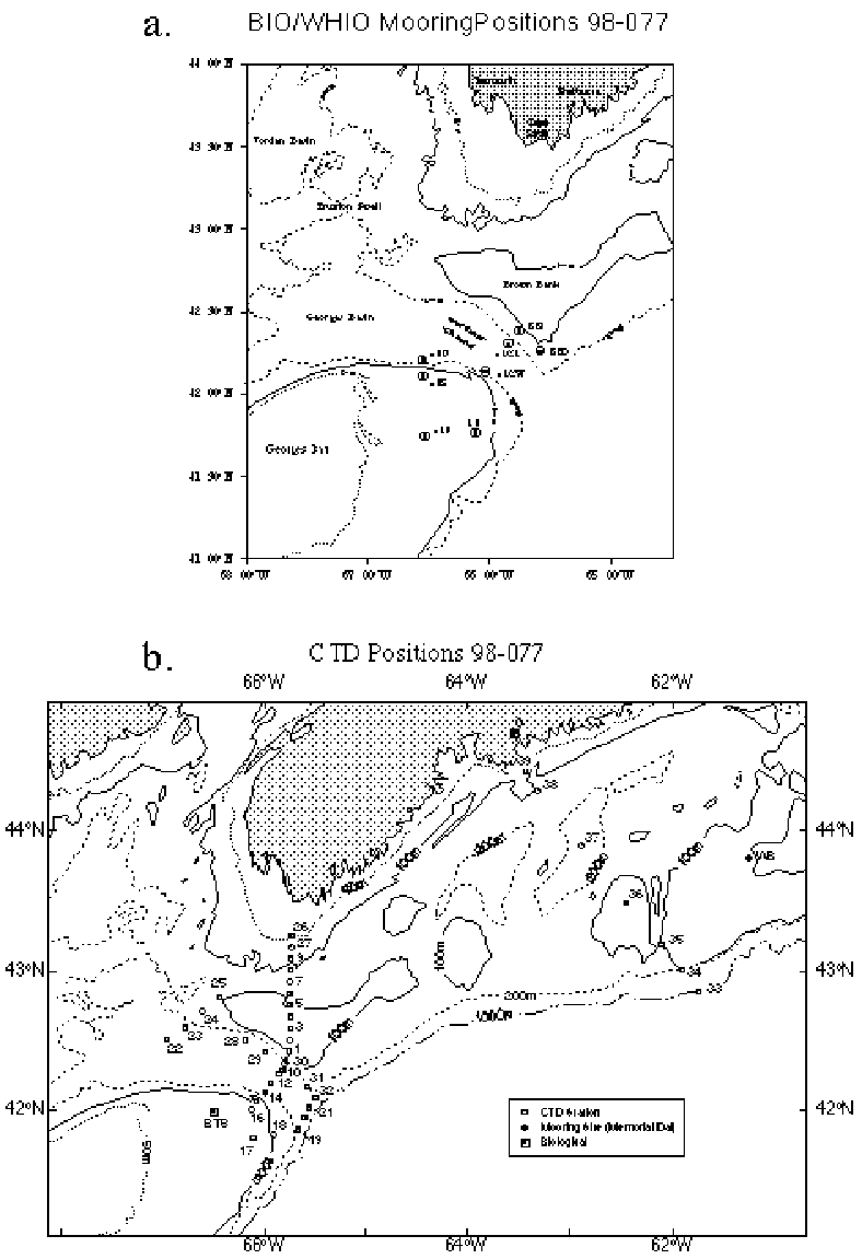
As this was a deployment cruise, no moored current meter data were gathered. However, eight moorings were placed at four different sites (Table 1, Fig.1a) for retrieval in July, 1999. Bathymetric data from the sounding surveys at new mooring sites, BBO and BBI, are found in Figure 2.
A total of 39 CTD stations (Fig.1b, Table 2) were occupied at the mooring sites and along the following sections:
1) Section Ia - from the 50 m isobath off Cape Sable to the outer edge of Browns Bank (Fig.3),
2) Section Ib - across Northeast Channel from Browns to Georges Bank on the mooring line, i.e. near the sill (Fig.4),
6) the Halifax Section (Fig.8).
The quality of the CTD salinity measurements is quite acceptable (Table 2a), especially considering the relatively high variability of the standards used. The YSI dissolved oxygen sensor showed a large offset with respect to the titrated values from the 50-m and near-bottom samples (Table 2a), but stable calibrations were obtained by linear regression of sensor vs. titrated values (Table 2b, Fig.9). The YSI sensor exhibited occasional noise, spikes, and hysteresis between the up- and downtraces. In addition, roughly 100 oxygen isotope samples were collected throughout the water column at even numbered stations (Fig.1b) for Dr. Robert Houghton of Lamont-Doherty Earth Observatory. Nutrient samples were collected throughout the water column as well at the even-numbered stations.
Date From(UTC) To(UTC) Operation
20 Nov. 1400 2100 Basin trials for CTD, VOPC, MVP, bongos
2100 1600(21) Depart BIO enroute to BBO mooring site
21 Nov. 1600 2200 Mooring placement operations at BBO, BBI
2200 0730(22) CTD1-9 on Section Ia
22 Nov. 1100 1600 Mooring placements at BBI;
1700 2100 Mooring placements at NECE, CTD10
2200 0900(23) CTD11-21 on Sections Ib, III
23 Nov. 1230 1530 Mooring placements at NECW
1630 2000 CTD30,31 at BBI, BBO; VOPC trial, CTD32
25 Nov. 1000 1400 CTD 33-35 on Halifax Section
1730 2000 Mooring recovery operations on Western Bank
(Memorial/Dalhousie Canada GLOBEC mooring)
26 Nov. 0000 0800 CTD 36-39 on Halifax Section
1100 Arrive BIO
The mooring operations proceeded largely without incident. The placement of the new moorings at BBO and BBI (Table 1; Fig.1a) was facilitated considerably by a newly developed link between the ship's navigation, sounder, and a SigmaPlot program to post the soundings on a chart at some desired interval. This product was available 10-15 min. after completion of the sounding lines. In addition, the new style of radar reflectors without sharp corners appear to be a lot safer, yet they are still visible on the radar screen at least 5-6 nm range.
Minor problems which arose during the moorings operations include: 1) the loss of a glass ball from one of the backup buoyancy packages during deployment of BBOA, and 2) an entanglement of the current meter and mooring line on NECWA.
On the last day of the voyage, recovery operations on behalf of Memorial University were conducted on Western Bank. The release code to a single mooring failed, so dragging operations commenced by paying out ~900m of cable from the Pengo winch, with drag hooks on the end. The mooring had been located by transponding with the release, and the ship circled the mooring position twice at roughly a constant range, then hauled back on the cable. A large strain came on the cable, then slackened again. Shortly afterward, the mooring floatation came to the surface and the entire mooring was recovered (float, Aanderaa RCM and release; Table 1a).
Problems/Recommendations:
(1) Refurbish all backup buoyancy packages, especially the "hard hats".
Hydrographic and chemical measurements were made at a total of 39 stations (Table 2) using a Seabird 9/11 Plus system (the "WOCE system"), equipped with a SBE 23Y Yellow Springs Instruments (YSI) dissolved oxygen sensor. The data were logged on a 33 Mhz 486 PC and post-processed between stations using SEABIRD's software. Once processed, the data were transferred to the VAX over the network for final tape backup to EXABYTE.
Water column sampling was accomplished with a SeaBird 24-bottle rosette. Duplicate nutrient and single oxygen isotope samples were drawn at roughly standard depths on the even numbered stations only. Duplicate dissolved oxygen samples were drawn at 50m. In addition, a calibration bottle was tripped at the bottom of each cast for duplicate nutrients and dissolved oxygen, plus a single salinity (see below).
The SeaBird system worked well throughout the cruise. The only mishap occurred when the meter block fell on top of the CTD in the winch room, due to the failure of an overhead piece of the track surrounding the boom. This made changing the block difficult, but did not hamper regular operations.
5a. Processing
The processing and data transfer to the VAX was initiated by a single command at the end of the station. This command, called PROCESS, starts a batch job that sequentially passes the data through a number of programs. Most were from SEABIRD's SEASOFT package. A few were custom written at BIO. The following is a summary of the processing procedure [modifications required for the manual bottle trip procedure are indicated in square brackets]:
(0) [Run MARKSCAN to create .BSR (bottle scan records) file from .MRK file, created by hitting (cntrl-f5) after a bottle is tripped.]
(1) Convert raw frequency data to binary pressure, temperature and conductivity using SEABIRD's DATCNV program. [.ROS file is based on either bottle flags within the data stream (normal), or on information from the .BSR file (manual procedure)]
(2) Split the file into the up and down traces using SEABIRD's SPLIT program.
(3) Check downcast for and mark any 'wild' data points with SEABIRD's WILDEDIT program.
(4) Filter downcast conductivity and temperature using SEABIRD's FILTER program. This is a low pass filter and we used a time constant of 0.045 seconds for conductivity and 0.15 seconds for temperature.
(5) Mark downcast scans where the CTD is moving less than the minimum velocity of 0.10 m/s using SEABIRD's LOOPEDIT program.
(6) Align downcast pressure, temperature and conductivity using SEABIRD's ALIGNCTD program by advancing the conductivity signal by 0.01 sec.
(7) Apply the thermal mass correction for the conductivity cell using SEABIRD's CELLTM program.
(8) Compute dissolved oxygen in ml/l using SEABIRD's DERIVE program.
(9) Create WOCE 2-dbar dataset using OSD program PRO-WOCE.
(10) Bin average downcast data to 1.0-dbar intervals using SEABIRD's BINAVG program.
(11) Compute downcast salinity, potential density(((), potential temperature((), and depth using SEABIRD's DERIVE program.
(12) Convert the down cast from binary to ASCII using SEABIRD's TRANS program.
(13) Convert downcast to ODF format using PCS program SEAODF.
(14) Create IGOSS message using PCS program ODF_IGOS.
(15) Prepare batch and command files to transfer the data to the VAX and create the input for SEABIRD's ROSSUM program using our customized MAKEFILE program.
(16) Check for bottles, then use ROSSUM to create the rosette summary file.
(17) Convert the resulting .BTL file to a format suitable for ingestion into Quattro PRO (.QAT file) using our customized QPROBTL program.
(18) Create the calibration file of merged up- and down-cast data using OSD program CALIB.
(19) Perform the FTP transfer of the raw binary and processed data to the VAX using OSD program CTD.XFER.
(20) Copy Quattro, downcast, and ODF files to appropriate directories and clean up.
Plots and status info displayed by the SEASAVE program during the acquisition are discarded when the program terminates. The post-processing plotting was not included in the batch job because SEABIRD's SEAPLOT program requires interactive operator attention. Plots produced after each station include T, S, O2, and (( vs. pressure and T vs. S. Section plots were produced with Igor Yakashev's contour package, modified to accept .ODF files.
5b. Calibration
At the base of each CTD cast one rosette bottle was tripped and a single salinity sample was drawn to be analyzed onboard with an Guildline AutoSal salinometer. Assuming that the temperature offset for the WOCE system is negligible, the comparison of the salinity standards against the SeaBird CTD (Table 2a below) shows that the offset is small but marginally different from zero. Nevertheless, the calibrations for both T and S are considered generally acceptable.
The performance of the YSI O2 sensor was similar to that on previous cruises. The surface values on the downtrace appeared to be fully equilibrated, thanks to a 3 min. waiting period (as suggested by the manufacturer), but there was usually a large hysteresis between the down- and uptraces in the vicinity of the pycnocline, and there were occasional spikes from the electronics. The hysteresis probably results from a mismatch of the temperature and O2 sensors in the probe and might be improved by applying filters with appropriate phase lags. The dissolved oxygen samples collected from calibration bottles were analyzed on board with the automated titration unit borrowed from Marine Chemistry. These "replicates" agreed to within a mean difference of 0.02 ml/l, with a standard deviation of 0.01 ml/l (Table 2a). Comparisons between the YSI measurements and bottle samples revealed a substantial mean offset between the sensor and titrated values. These offsets were most pronounced and variable at the first 11 stations of the cruise, after which the malfunctioning sensor was replaced. Over the remaining stations, the mean offset was actually larger, but the standard deviation about that mean was reduced by a factor of three (Table 2a). A linear regression of titrated on YSI sensor values at 50 m and the bottom provides an effective calibration (Table 2b) with high correlation and relatively low standard error ((0.16 ml/l). The corrected CTD oxygens show a reasonable scatter about the 1:1 line (Figure 9).
Problems/Recommendations:
(1) Efforts should be made to remove the hysteresis between the up and down traces from the YSI sensor by application of filters with various lags.
5c. Sections
CTD sections Ia,b, II, III, IV, and the Halifax Section (Figs. 3-8) depict hydrographic conditions, 1) along the eastern boundary of the Gulf of Maine, 2) across the sill in Northeast Channel, 3) down the western flank of Browns Bank, 4) from Georges Bank across the mouth of Northeast Channel, 5) along the 200 m isobath on the eastern side of the Channel, and 6) across the entire Scotian Shelf off Halifax, respectively. Section Ia (Fig.3) shows a surface layer of fresh water extending out from Cape Sable over the shelf, with a large bolus of S<31 centred over the inshore edge of Browns Bank. The lowest temperatures (T<4oC) are found in the deepest part of the channel north of Browns. The inshore region off Cape Sable is vertically well mixed, as expected, while the outer edge of Browns is stratified by both temperature and salinity. The cold deep water (<5oC) disappears over the outer shelf, as evidenced by the stark differences in the deeper T-S properties at CTD1-3 versus those at the inshore stations. The malfunction of the YSI oxygen sensor for the first 11 stations prevents the construction of an O2 section.
The distribution of deep water properties on Section Ib (Fig.4) shows relatively cool and fresh conditions (8<T<10oC; S<35) in the Channel at depths of 100-200m, indicating the absence of Warm Slope Water or Gulf Stream water in the inflow currents. A weak oxygen minimum (O2<5 ml/l) is centred at roughly 200 m in the middle of the Channel. The warm, fresh (8<T<10 oC; S<31) surface layer over Browns Bank, remarkedly, extends most of the way across the Channel (beyond CTD14), suggesting a potential cross-over event has occurred recently or is in progress. Moreover, the fresh surface waters at CTD11,12 appear to be interleaving with a warmer and saltier water mass, perhaps from offshore. The density section reveals that the water column on Browns is much more stratified than on Georges, primarily because of the fresh surface waters.
Section II (Fig.5) again reveals a fresh surface layer over Georges Basin, with minimum surface salinities at CTD23,24 appearing to be slightly diluted versions of those found over the outer edge of Browns (CTD1,11,12). A cold intermediate layer also appears at CTD23,24, but seems to disappear in both deeper (CTD22) and shallower waters (CTD25). Deep salinities do not reach 35, again demonstrating the absence of Warm Slope or Gulf Stream waters. A broad oxygen minimum lies below 150 m on the deeper part of the section.
Section III (Fig.6) again shows the warm, fresh surface layer extending across the entire mouth of Northeast Channel, with near-surface salinities <32 at the 100m isobath on Georges Bank but rising above 32 at the 90-m contour. But the surface layer on the eastern side of the Channel is not only fresher, but warmer than on the western side, indicating perhaps a weak cross-over with much dilution by stronger mixing on the western side. Density stratification is also weaker on the western side. A cold intermediate layer is most pronounced at CTD 19, but extends eastward to CTD32 in a weakened form. Salinities in the deeper waters are slightly higher than on the interior sections, but again there is no evidence of large quantities of Warm Slope or Gulf Stream Waters. The core of the oxygen minimum layer lies roughly between 150 and 250 m.
Conditions on Section IV (Fig.7), from Georges Basin to the mouth of Northeast Channel between the eastern 130 and 200m isobaths, are quite variable, showing pockets of cold intermediate waters at various locations and depths. One consistent feature, however, is the presence of the fresh (S<31) surface waters along the entire section. However, at the offshore end of the section (CTD31,32), the surface layer also contains a warm, relatively saline core, suggesting slope water influence. At depth, these data give no indication of a recent Warm Slope Water intrusion along the inflow axis of the Channel, since temperatures and salinities do not exceed 9.0oC and 35, respectively The truncated oxygen section shows a regular decrease from the surface down to a minimum near 200 m.
The Halifax Section data (Fig.8) reveal two low-salinity cores in the surface water masses. Inshore (CTD38-39) the surface salinity is less than 30 and a distinct cold intermediate layer lies below, centred at 50-100m. At the shelf break, another fresh core is found at CTD34, with properties that appear to be similar to those nearer the coast, but heavily diluted by the offshore water masses represented by properties at CTD33,35. The intermediate temperature minima are distinct at all stations except CTD 36 and CTD 33, where the temperatures barely drop below 7oC. Again, the deep properties in Emerald Basin do not show the presence of Warm Slpoe Water.
The RDI ADCP was run continuously over the cruise in the bottom track mode. The velocity measurements were made in 100 4-m bins below the transducer depth (4.9 m). In the standard acquisition mode, 10-ping ensembles were averaged over 5 minutes to create processed profiles of velocity, beam intensity, etc. The RDI system appeared to work well over the cruise.
In addition to the ADCP, several instruments for making biophysical measurements at sea were tested and calibrated. During trials in Bedford Basin (44o 41.4'N, 63o 38.2'W) prior to the cruise and later on Georges (42o 00.0'N, 66o 30.0'W) and Browns (42o 21.5'N, 65o 44.6'W) Banks, the following assessments were made:
The information gained from all these trials will be utilized in future missions.
Problems/Recommendations:
Acknowledgements:
We are greatly indebted to the officers and crew of the C.S.S. Hudson for their skilled assistance and friendly cooperation, which was vital to the success of this mission.
Mooring Site N. Lat. Placement Instrument
No. (Depth,m) W. Long. Time(Z),Date (Depth,m)
1290 BBI 42o20.53' 1422, Nov.22 RCM7592(30)
(120) 65o44.13' RCM4355(50)
RCM5574(100)
1290A BBIA 42o20.77' 1504, Nov.22 RCM7525(16)
(122) 65o43.95'
1291 BBO 42o09.75' 2007, Nov.21 RCM6403(30)
(120) 65o34.31' RCM3196(50)
RCM4195(100)
1291A BBOA 42o09.99' 2048, Nov.21 RCM7122(12)
(118) 65o34.31'
1292 NECEA 42o17.75' 1955, Nov.22 MCAT????(23)
(216) 65o50.41' RCM7013(24)
1293 NECE 42o17.69' 1830, Nov.22 RCM4342(35)
(215) 65o50.66' RCM9355(55)
RCM4602(105)
RCM5577(155)
1294 NECWA 42o07.79' 1456, Nov.23 RCM5359(23)
(216) 66o00.91'
1295 NECW 42o07.61' 1357, Nov.23 RCM7131(33)
(213) 66o00.84' RCM9607(53)
RCM2664(103)
RCM6411(153)
Mooring Site N. Lat. Recovery Instrument Comments
No. (Depth,m) W. Long. Time(Z),Date (Depth,m)
Mem/Dal. Western 43o48.8' 1941, Nov.25 RCM(37) recovered by dragging
Bank 61o18.1' mooring complete
TABLE 2. CTD Stations During Hudson 98-077, 20-26 November 1998
| Stn. No. | Latitude | Longitude | Sounding | Yearday | Date Time(UTC) | Site |
| (m) | ||||||
| 0 | 44 41.532 N | 63 38.382 W | 66 | 324 | 11/20/98 15:18 | |
| 1 | 42 25.590 N | 65 45.072 W | 97 | 326 | 11/22/98 0:16 | |
| 2 | 42 30.030 N | 65 44.868 W | 84 | 11/22/98 1:09 | ||
| 3 | 42 35.190 N | 65 44.538 W | 88 | 11/22/98 2:08 | ||
| 4 | 42 40.290 N | 65 44.730 W | 88 | 11/22/98 2:49 | ||
| 5 | 42 45.120 N | 65 45.108 W | 101 | 11/22/98 3:42 | ||
| 6 | 42 49.980 N | 65 45.228 W | 105 | 11/22/98 4:30 | ||
| 7 | 42 55.062 N | 65 45.180 W | 149 | 11/22/98 5:27 | ||
| 8 | 42 59.970 N | 65 44.478 W | 135 | 11/22/98 6:15 | ||
| 9 | 43 5.028 N | 65 44.538 W | 90 | 11/22/98 7:09 | ||
| 10 | 42 16.998 N | 65 49.662 W | 215 | 11/22/98 20:43 | ||
| 11 | 42 20.022 N | 65 47.742 W | 197 | 11/22/98 22:17 | ||
| 12 | 42 15.828 N | 65 51.720 W | 224 | 11/22/98 23:05 | NECE | |
| 13 | 42 11.808 N | 65 55.812 W | 222 | 11/22/98 23:58 | ||
| 14 | 42 7.722 N | 65 59.592 W | 220 | 327 | 11/23/98 0:54 | NECW |
| 15 | 42 3.828 N | 66 4.680 W | 88 | 11/23/98 1:51 | ||
| 16 | 42 0.162 N | 66 8.412 W | 90 | 11/23/98 2:32 | ||
| 17 | 41 48.480 N | 66 7.722 W | 89 | 11/23/98 3:48 | ||
| 18 | 41 49.488 N | 65 54.708 W | 110 | 11/23/98 4:50 | ||
| 19 | 41 51.318 N | 65 40.872 W | 693 | 11/23/98 6:01 | ||
| 20 | 41 56.580 N | 65 36.342 W | 697 | 11/23/98 7:12 | ||
| 21 | 42 0.642 N | 65 33.552 W | 790 | 11/23/98 8:23 | ||
| 22 | 42 30.342 N | 66 57.720 W | 322 | 328 | 11/24/98 0:18 | |
| 23 | 42 35.688 N | 66 46.770 W | 218 | 11/24/98 1:37 | ||
| 24 | 42 42.708 N | 66 36.732 W | 164 | 11/24/98 2:45 | ||
| 25 | 42 48.378 N | 66 26.382 W | 98 | 11/24/98 4:00 | ||
| 26 | 43 14.910 N | 65 44.388 W | 37 | 11/24/98 7:14 | ||
| 27 | 43 9.762 N | 65 44.382 W | 49 | 11/24/98 8:29 | ||
| 28 | 42 30.768 N | 66 10.860 W | 217 | 11/24/98 13:31 | ||
| 29 | 42 25.590 N | 65 58.902 W | 222 | 11/24/98 14:54 | ||
| 30 | 42 21.228 N | 65 44.550 W | 130 | 11/24/98 16:27 | BBI | |
| 31 | 42 10.248 N | 65 34.692 W | 117 | 11/24/98 18:39 | BBO | |
| 32 | 42 5.382 N | 65 30.492 W | 685 | 11/24/98 19:26 | ||
| 33 | 42 50.862 N | 61 44.088 W | 1012 | 329 | 11/25/98 10:03 | |
| 34 | 42 59.970 N | 61 53.682 W | 149 | 11/25/98 12:06 | ||
| 35 | 43 11.022 N | 62 6.048 W | 95 | 11/25/98 13:45 | ||
| 36 | 43 28.872 N | 62 26.862 W | 79 | 330 | 11/26/98 0:11 | |
| 37 | 43 53.022 N | 62 53.100 W | 262 | 11/26/98 2:58 | ||
| 38 | 44 15.930 N | 63 19.140 W | 144 | 11/26/98 6:09 | ||
| 39 | 44 24.072 N | 63 26.502 W | 79 | 11/26/98 7:50 |
TABLE 2a. Temperature and Salinity Calibration Results for Hudson 98-077
QUANTITY NO. SAMPLES MEAN DIFF. STD. DEV.
CTD vs. Standard
Salinity:
CTD-AutoSal. 18 -0.007 0.005
Dissolved Oxygen:
YSI-Titration(12-38) 27 0.77 0.17
Standard vs. Standard
Dissolved Oxygen:
Btl.1-Btl.2.(0-38) 34 0.02 0.01
______________________________________________________________________________
TABLE 2b. Dissolved Oxygen Regression Results for Hudson 98-077
Y = aX+b (Y=titration, X=sensor)
SENSOR(CTD) NO. SAMPLES a((a b((b(ml/l) ((Y(ml/l) r2
YSI(12-38) 27 0.898(0.042 -0.128(0.261 (0.160 .949 0.98
______________________________________________________________________________
FIGURE CAPTIONS:
Figure 1 a) Mooring sites, and b) CTD and biological stations for C.S.S. Hudson
Cruise 98-077, 20-26 November 1998
Figure 2 Sounding survey for the placement of subsurface moorings and guard buoys at sites: (a) BBO; 21 November 1998, and (b) BBI, 22 November 1998.
Figure 3 Hydrographic section Ia (CTD1-9,26,27) from Cape Sable to the offshore edge of
Browns Bank.
(a) temperature,
(b) salinity,
(c) sigma-(,
(d) dissolved oxygen (NO DATA)
(e) temperature vs. salinity, and
(f) station map
Figure 4 Hydrographic section Ib (CTD1,11-16) across Northeast Channel at the mooring line.
(a) temperature,
(b) salinity,
(c) sigma-(,
(d) dissolved oxygen,
(e) temperature vs. salinity, and
(f) station map
Figure 5 Hydrographic section II (CTD22-25) on the western flank of Browns Bank.
(a) temperature,
(b) salinity,
(c) sigma-(,
(d) dissolved oxygen,
(e) temperature vs. salinity, and
(f) station map
Figure 6 Hydrographic section III (CTD17-21,32) across the mouth of Northeast Channel
(a) temperature,
(b) salinity,
(c) sigma-(,
(d) dissolved oxygen,
(e) temperature vs. salinity, and
(f) station map
Figure 7 Hydrographic section IV (CTD24,28,29,30-32) along the slope water inflow axis ((130-200m isobath) from Georges Basin to the mouth of Northeast Channel.
(a) temperature,
(b) salinity,
(c) sigma-(,
(d) dissolved oxygen (replace with CTD23,28-29,21),
(e) temperature vs. salinity, and
(f) station map
Figure 8 Halifax hydrographic section (CTD33-39) from the Scotian Shelf break to Halifax.
(a) temperature,
(b) salinity,
(c) sigma-(,
(d) dissolved oxygen,
(e) temperature vs. salinity, and
(f) station map
Figure 9 Calibrated data for the YSI dissolved oxygen sensor. Linear regression in Table 2b has been applied to CTD oxygens, which are then plotted against titrated values. Bold line represents a linear regression of corrected CTD on titrated data.
APPENDIX Diagrams for Moorings Placed During C.S.S. Hudson Cruise 98-077
20-26 November 1998
a) BIO moorings: BBO, BBOA, BBI, BBIA, NECWA,NECW,NECEA,NECE
b) Shallow (130m) guard buoy, Deep (210m) guard buoy
Figure 1. a) Mooring sites, and b) CTD and biological stations for C.S.S. Hudson Cruise 98-077, 20-26 November 1998.
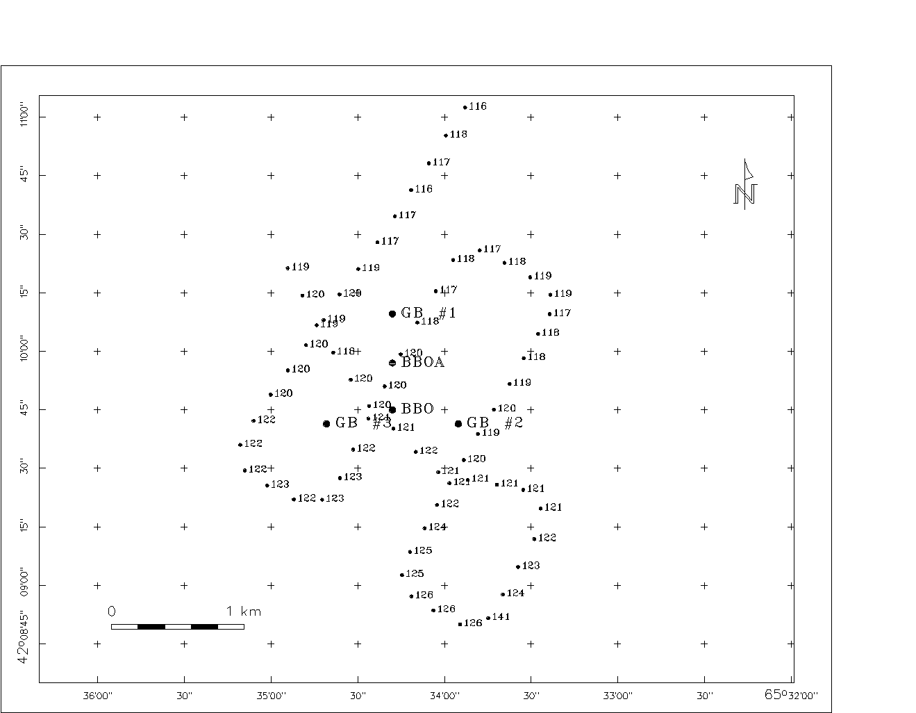
Figure 2a. Sounding Lines for Placement of BBO Moorings; 21 November 1998
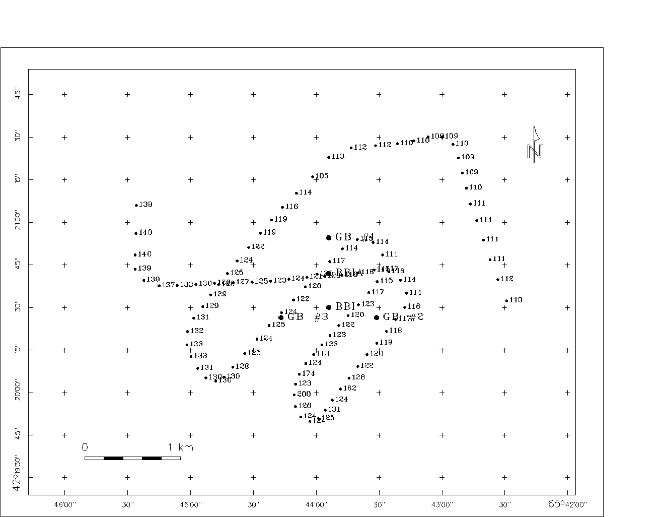


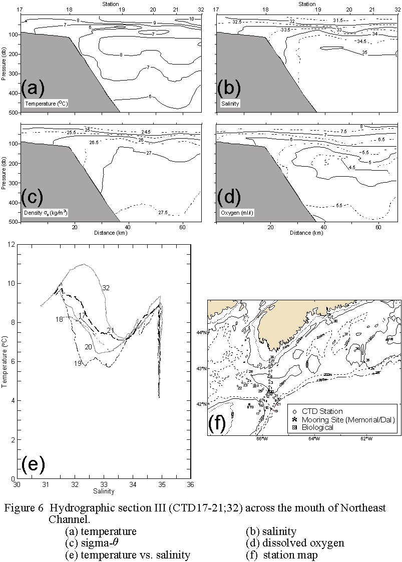
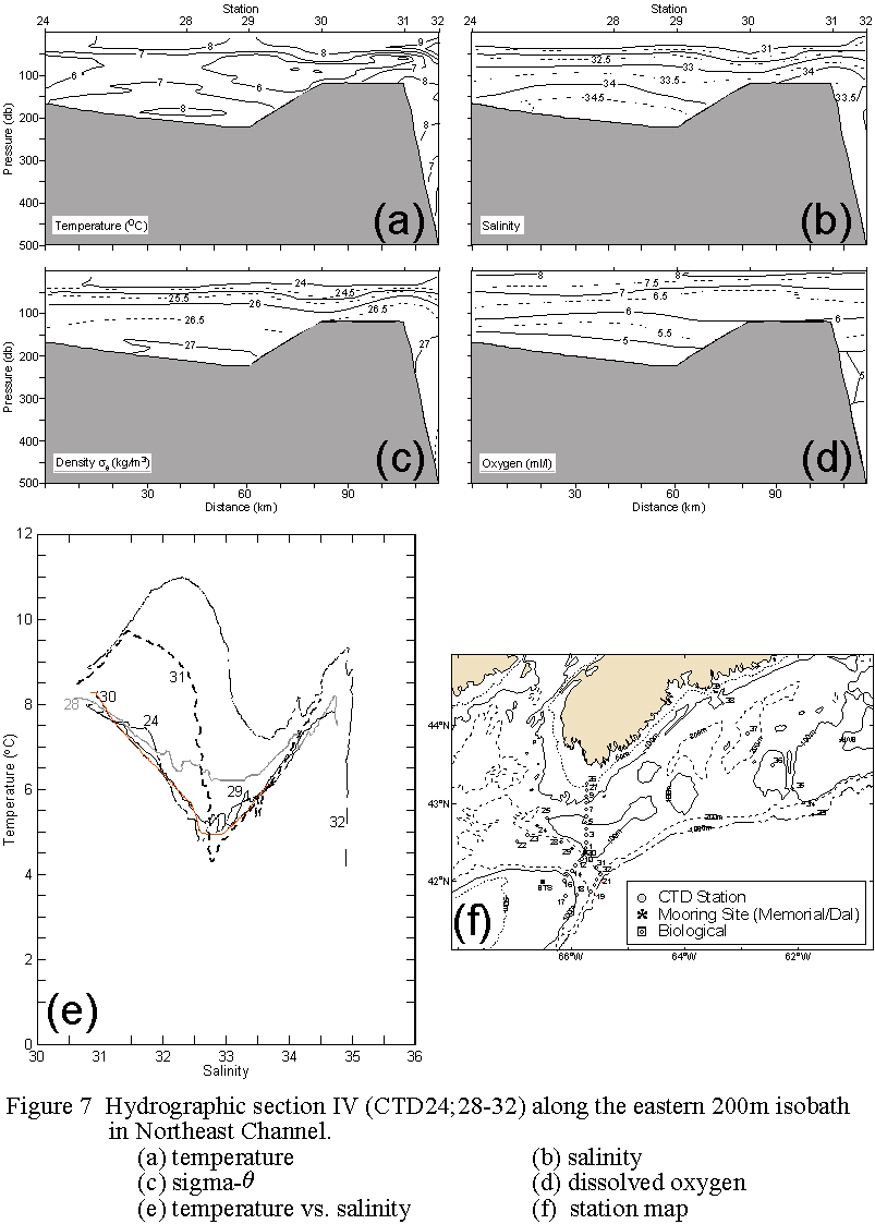

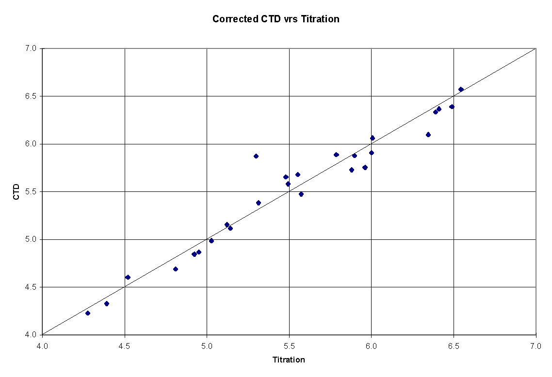
 Figure 9. Calibrated data (i.e. Table 2b regression applied) from the YSI
dissolved oxygen sensor. Bold line is 1:1.
Figure 9. Calibrated data (i.e. Table 2b regression applied) from the YSI
dissolved oxygen sensor. Bold line is 1:1.