This report was prepared by R. Schlitz and J. Manning.
This Research was sponsored by the NOAA Coastal Ocean Office under funding for the U.S. Global Ocean Ecosystems Dynamics Program Northwest Atlantic Field Studies, Phase 2
Cruise Report
Table 1. Summary of information on the moorings set during R/V OCEANUS (OC296)
Table 2. Event log for OC296
Figure 1. Track for R/V OCEANUS Cruise
296, 12-17 January, 1997 (OC296)
Figure 2. Moored Array Set during
OC296. Each position shows the mooring number and
identifying letter on the surface buoy. The green are for
single-point surface moorings and
the red are for moorings that have a tripod. The blue numbers
represent locations for GLOBEC
Broad-Scale stations
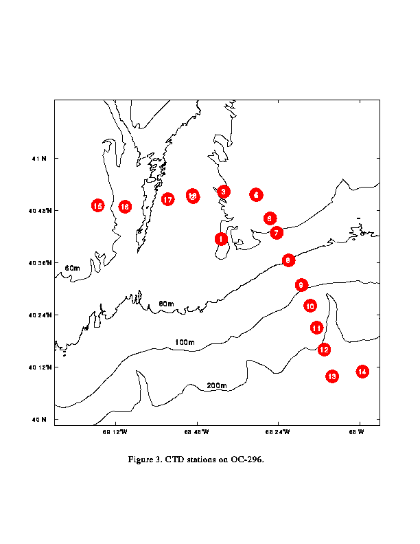
Figure 3. Positions of CTD Stations
Completed during OC296
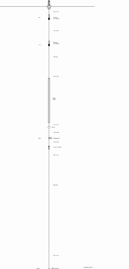
Figure 4. Diagram of Surface Mooring
at Site 1
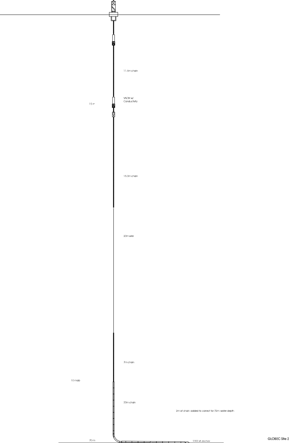
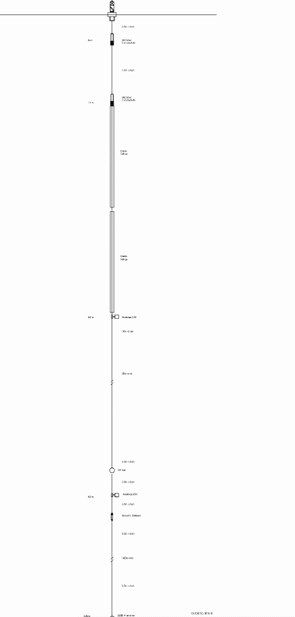
Figure 5. Diagram of Surface Mooring
at Site 2
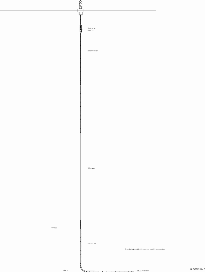
Figure 6. Diagram of Surface Mooring
at Site 3
Figure 7. Diagram of Surface Mooring
at Site 4
Figure 8. Diagram of Surface Mooring
at Site 5
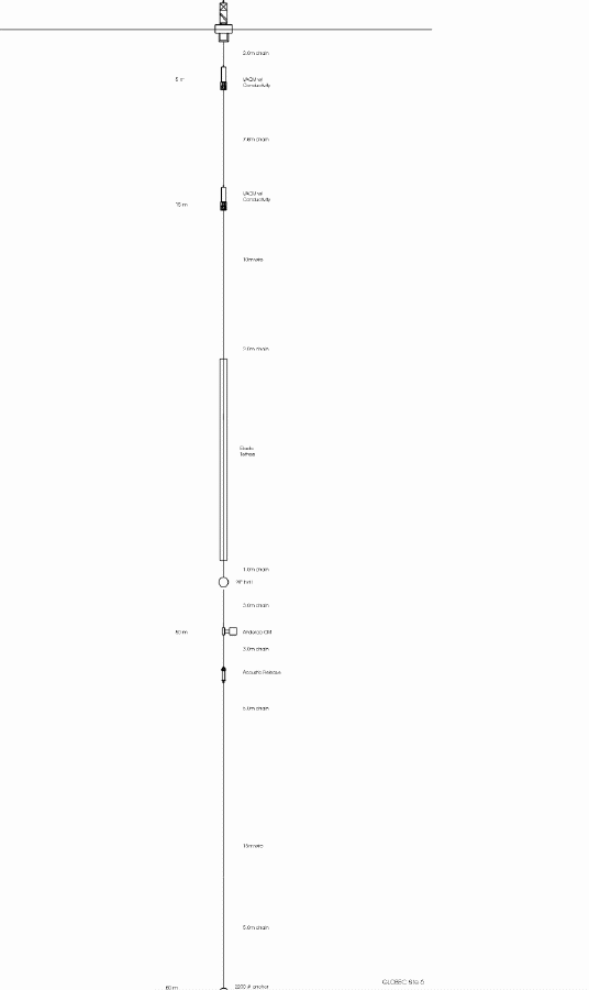
Figure 9. Diagram of Surface Mooring
at Site 6
Figure 10. Diagram of Surface Mooring
at Site 7
Figure 11. Diagram of Surface Mooring
at Site 8
Figure 12. Diagram of Surface Mooring
at Site 9
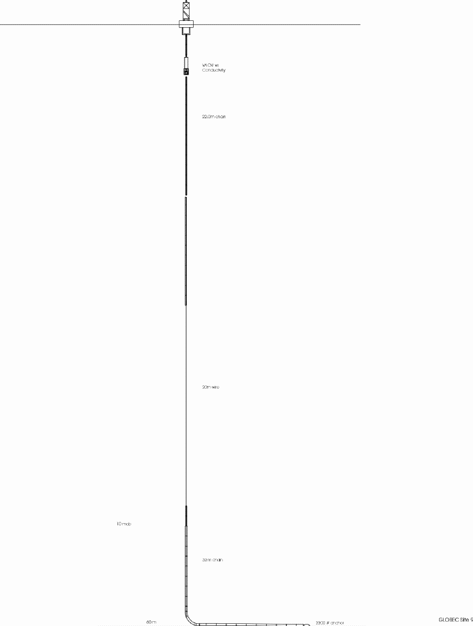
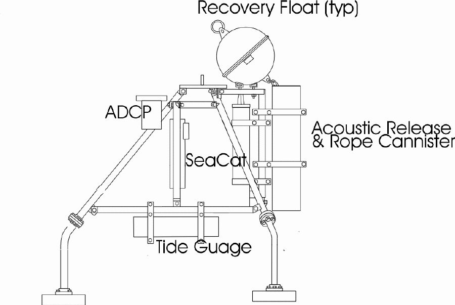
Figure 13. Diagram of Tripods Located
at Sites 3, 4, 5, and 9
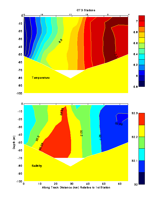
Figure 14. Temperature and Salinity
Sections across Great South Channel along the Mooring Line from CTD
Data Collected during OC296
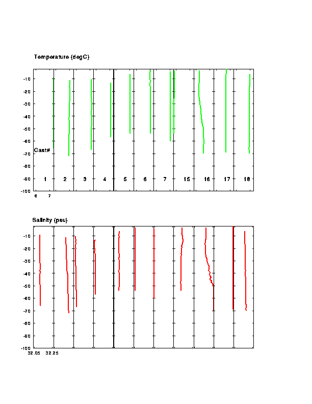
Figure 15. Temperature and Salinity
Profiles from CTD Stations in Weakly Stratified Water during OC296
Figure 16. Temperature and Salinity
Sections across the Southern Flank of Georges Bank along the Mooring
Line from CTD Data Collected during OC296 Cruise Report
Woods Hole, MA to Woods Hole, MA
12-17 January 1997
The primary purpose of the cruise was to set an array of nine
moorings in the vicinity of Great South Channel as part of the U.S.
GLOBEC Program Northwest Atlantic Field Studies, Phase 2. A
secondary purpose was to describe the hydrographic regime in the
vicinity of the moored array. The overall goal is to examine
retention (in the form of recirculation around the inner part of
Georges Bank) and losses from the southern flank of the Bank into
Slope Water or westward into the Middle Atlantic Bight.
The R/V OCEANUS departed Woods Hole at approximately 1500 EST on
Sunday, 12 January 1997 after delaying two days due to weather and
sea conditions at the mooring sites. The cruise track is found on
Figure 1. Upon leaving, the shipboard
alongtrack sensors began recording, including meteorological (IMET)
and sea surface parameters as well as 150 kHz narrow-band and 300
kHz broad-band ADCP systems. We arrived at mooring site 9 (Figure 2) before dawn on Monday, 13 January
with the intention of setting a surface mooring. The sea conditions
were too rough to allow the safe deployment of the surface marker
(carried forward on the starboard side) so we moved to site 3 and
set the first mooring. This and each subsequent surface mooring
were set anchor last. Steaming to site 2, a second surface mooring
was set. We returned to site 9 with the intention of trying to set
the entire mooring. We finished the surface buoy but decided to
wait until the next day for the tripod as darkness and fatigue came.
During Monday night CTD stations 1-4 (Figure 3) were completed at mooring sites 9,
2, 3, and 4 (planned). On each station one salinity sample was
collected at the bottom of the cast for calibration of the
conductivity sensor on the instrument. An offset in the pressure of
9-10 db was noted in the data. This was later traced to a setting
in the configuration files and corrected.
Mooring work resumed at site 5 on Tuesday morning. A tripod
containing the ADCP was prepared and lowered using a polypropylene
slip-line. When the line was released to be retrieved after going
slack as the tripod settled on the bottom, tension returned
indicating a problem. As the line was carefully hauled back a large
wuzzle appeared with the tripod at the end. We successfully
recovered the tripod and unsnarled the line. The probable cause was
a swivel that did not function well causing the line to twist around
itself. After some changes in the rigging, the tripod was lowered
on a single line containing flotation and an acoustic release
attached to the tripod. This time the tripod was deployed with no
problems about 0.1 nm from the surface mooring. We then set the
tripod at site 3 keeping the same distance from the surface mooring.
Finally the entire mooring at site 4 was deployed, surface buoy
followed by the tripod, before stopping mooring operations for the
day.
A line of CTD stations (5-13) starting at mooring 4 and running
along the line of planned moorings across the southern flank of
Georges was then done, as well as one station (14) toward the east
in deep water. The AVHRR images showed either a warm-core ring or
meander of the Gulf Stream (clouds prevented any clear view)
impinging the continental shelf east of the mooring line. These CTD
stations were completed during Tuesday night before steaming back to
site 8.
On Wednesday morning the first mooring was set at site 8. The
original design called for a single length of elastic tethers. This
plan was modified to include a second length of tethers in line,
adding a margin of safety in high waves for this mooring on the
southern flank of Georges Bank. After setting the mooring at site
8, sites 7 and 5 (surface mooring and tripod) were completed before
going to site 7. The tripod at site 5 needed to be set before
mooring 7 since the sub-surface sphere to be used on mooring 7 was
required as flotation above the release in the lowering line for the
tripod. Finally mooring 6 was set about 2200 local time on
Wednesday at the end of a very long day.
Since the weather report was for increasing winds leading to
gale conditions beginning during Thursday morning we decided to
steam directly to site 1 and to be in a position to set the mooring
as soon as possible in the morning. This also allowed rest for
those who had spent most of Wednesday day on deck. The mooring at
site was set early in the morning under the most favorable sea
conditions for all mooring work.
A series of CTD stations then began west of site 1 across Great
South Channel along the mooring line. Four stations (15-18) were
completed as winds and seas rapidly increased. An updated weather
forecast now called for storm warnings in our area without
appreciable improvement for three days. A discussion between the
Master and Chief Scientist resulted in cancellation of the remaining
scientific program and immediate return to Woods Hole. R/V OCEANUS
steamed under heavy conditions south of Nantucket and Martha's
Vineyard into Vineyard Sound arriving in Woods Hole at about 0900
EST on Friday, 17 January 1997. Both the main and 01 decks were
covered with 5-8 cm of slush and icicles hung from the rail and CTD
cage.
The primary goal of OC296, deployment of an array of moorings to
examine factors leading to retention or loss of water and plankton
along the southern flank of Georges Bank, was successful. A window
of favorable weather and seas allowed the work to be done between 13
and 16 January 1997. Figure 4, 5, 6, 7, 8,9, 10, 11, and 12 show
the surface moorings at each site and Figure
13 shows the tripods that were deployed at sites 3-5 and 9.
Data for the moorings in the array are summarized in Table 1.
A second related goal, characterization of the hydrography in
the area surrounding the moored array was only partially successful.
Sections across Great South Channel and the southern flank of
Georges Bank along the mooring lines can be synthesized from the
data. However near-synoptic sections with the array in place are
missing. Also examination of the warm-core ring/meander was not
possible due to weather and sea conditions.
Temperature and salinity sections across Great South Channel
along the mooring line are shown in Figure
14. The temperature structure is typical of conditions during
the winter season, horizontal variations across Great South Channel
were greater than vertical changes. Only at station 16 was any
vertical structure apparent with a variation of ~0.3° C from
surface to bottom. Salinity was nearly constant at each station and
showed a relative maximum in the horizontal corresponding to the
region of deepest bathymetry in the channel. The reason for this is
not obvious from the data. The temperature and salinity plots at
stations in the well mixed area are shown in Figure 15. Noticeable variations of
temperature and salinity with depth occur only at station 16 as
stated above.
The section across the southern flank (Figure 16) shows typical weakly stratified
conditions over the shelf for this season. From the 200m isobath
seaward, in the slope regime, the temperature and salinity
characteristics at depths between 100-150m are consistent with
values at the inner edge of the Gulf Stream. In fact two partial
AVHRR images of the area on 22 January 1997 clearly show a warm-core
ring just southwest of the hydrographic section.
The event log for R/V OCEANUS 296 is presented in Table 22.
List of Figures
R/V OCEANUS Cruise OC296
1. Purpose of Cruise
2. Cruise Narrative
3. Cruise Results
Table 1. Summary of information on the moorings set during
OC296. This is an array to study physical factors causing
recirculation around Georges Bank and losses from the region.
| Mooring # | Surface | Latitude | Latitude Min | Longitude | Longitude Min | Depth (m) | Argos Ident |
| 1 | Y | 40° | 49.001´ | 69° | 09.003´ | 70 | 14315 |
| 2 | B | 40° | 51.247´ | 68° | 49.011´ | 72 | 14212 |
| 3 | C | 40° | 51.752´ | 68° | 40.012´ | 62 | 14311 |
| 4 | D | 40° | 52.020´ | 68° | 30.609´ | 52 | 14309 |
| 5 | E | 40° | 42.997´ | 68° | 24.502´ | 61 | 14314 |
| 6 | L | 40° | 37.610´ | 68° | 21.363´ | 80 | 14316 |
| 7 | A | 40° | 31.005´ | 68° | 17.174´ | 101 | 14308 |
| 8 | I | 40° | 14.722´ | 68° | 10.198´ | 325 | 14310 |
| 9 | F | 40° | 42.017´ | 68° | 40.524´ | 61 | 14313 |
| Tripod # | ADCP Ident | ||||||
| 3 | 40° | 51.851´ | 68° | 39.998´ | 64 | 164 | |
| 4 | 40° | 51.993´ | 68° | 30.503´ | 59 | 165 | |
| 5 | 40° | 42.947´ | 68° | 24.400´ | 61 | 139 | |
| 9 | 40° | 41.871´ | 68° | 40.530´ | 67 | 136 |
The event log is available on-line using the URL
http://globec.whoi.edu/jg/serv/globec/gb/eventlogs.html1?cruiseid=OC296.
Table 2: Event log
| Name | Position | Organization | ||
| Ronald Schlitz | Chief Scientist | NOAA/NMFS, Woods Hole, MA | ||
| James Manning | Oceanographer | NOAA/NMFS, Woods Hole, MA | ||
| Judith Gray | Meteorologist | NOAA/COP, Washington, DC | ||
| William Strahle | Electrical Engineer | USGS, Woods Hole, MA | ||
| Marinna Martini | Electrical Engineer | USGS, Woods Hole, MA | ||
| Richard Rendigs | Geologist | USGS, Woods Hole, MA | ||
| Peter Gill | Geologist | USGS, Woods Hole, MA | ||
| Dann Blackwood | Photographer | USGS, Woods Hole, MA | ||
| Andrew Eliason | Electrical Engineer | Eliason Data Services, Mashpee, MA | ||
| Jennifer Frese | Student | Bowdoin College, Brunswick, ME | ||
| Steven Cross | Technician | WHOI, Woods Hole, MA | ||
| Laura Stein | SSSG Technician | WHOI, Woods Hole, MA |