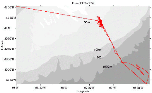
Figure 1. Track for R/V OCEANUS Cruise 339 (OC339), 17-25 March 1999.
Cruise Report
R/V Oceanus Cruise OC339
Woods Hole, MA to Woods Hole, MA
17-25 March 1999
Acknowledgments
During OC 339 an array of moorings at seven closely-spaced sites was set on the southern flank of Georges Bank. In addition, hauls with a 1 m MOCNESS system were rapidly completed. The nature of the work required long and arduous hours by all on board R/V OCEANUS. Our success was possible due to the skill of the entire staff of R/V OCEANUS and the scientific party who all worked beyond the normally expected schedules.
This report was prepared by R. Schlitz with contributions from J. Manning, R. G. Lough, E. Broughton, and R. Gamble.
This research was sponsored by the NOAA Coastal Ocean Office under funding for the U. S. Global Ocean Ecosystem Dynamics Program Northwest Atlantic Field Studies, Phase III.
Table of Contents
1. Purpose of Cruise
2. Cruise Narrative
3. Cruise Results
Table 1. Summary of information on the moorings set during OC339
Table 2. Event log for OC339
4. Scientific Personnel on Cruise OC339
1. Purpose of Cruise
This cruise had two major goals. The first was to set a closely-spaced array of moorings at seven sites centered at the 60 m isobath on southern Georges Bank. The array was situated approximately perpendicular to the local topography spanning the historical location of the tidally mixed front. The second goal was to examine the abundance, distribution, and condition of ichthyoplankton, specifically cod and haddock, along the array in relation to the hydrographic structure. The overall GLOBEC goal is to focus on the physical processes that determine the circulation within the regime of the tidally mixed front on southern Georges Bank and associated dynamics of plankton.
2. Cruise Narrative
The R/V OCEANUS departed from Woods Hole at approximately 10:00 EST on Wednesday, 17 March,1999. The cruise track is found on Figure 1.
Figure 1.
Track for R/V OCEANUS Cruise 339 (OC339), 17-25 March 1999.
Soon after leaving we learned that the anchor windlass had blown a seal and was not repairable at sea. Plans for anchoring were canceled. We steamed under reasonably good conditions down Nantucket Sound and through Great Round Shoals for first location, Site 4 (L) (Figure 2).
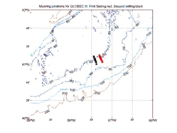
Figure 2A.
Moored array set during OC339. The positions for the array set during OC339 are in
red. The second setting of the array in black are shown for reference: A.
The setting of the arrays in relation to the regional bathymetry for Georges Bank.
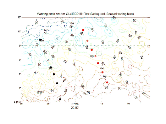
Figure 2B.
Moored array set during OC339. The positions for the array set during
OC339 are in red. The second setting of the array in black are shown for reference:
B. The arrays in relation to the detailed bathymetry along the southern flank. These
moorings are designated Sites 1-7 from North to South with particulars presented in
Table 1.
On Thursday 18 March 1999 at 00:10 EST we arrived at Site 4 to test the MOCNESS (MOC1) and CTD systems. MOC1 and CTD stations were successful, including some cod larvae caught in the nets. Preparations for setting the first surface float began at 06:00 EST. A slack surface buoy at Site 4 (L) was launched at 12:55 Z in 61-62 m of water at 41-06.559 N and 67-16.212 W. During setting, a “science buoy” was spotted about 1.5 nm from us. It was in fact a large navigation buoy, unknown source, red, marked AJ 2 with red light and gong. We then moved to Site 6 (F). The surface marker was set and anchor released at 14:45 Z in 66 m of water at 41-04.274 N and 67-14.896 W. Steaming next to Site 2 (A), a surface buoy was launched at 16:13 Z at 41-08.700 N and 67-17.702 W in 60 m of water. Next operation was the setting of a sub-surface mooring a Site 2. It was set at a bearing of 070 deg. true and a distance of 0.05 nm from the surface buoy at 19:21 Z at 41-08.721 N and 67-17.634 W in 60 m of water. There was a small problem since one thermistor was not attached to the string. A sub-surface mooring at Site 4 was set at 21:58 Z at 41-06.581N 67-16.146 W in 62 m of water, without incident. The extra thermistor was placed in the lower part of the water column to better define the thermal structure. We steamed to Site 6 and set the final sub-surface mooring. The anchor was dropped at 23:48 Z at 41-04.279 N and 67-14.832 W in 66 m of water. This completed the mooring operation for the day. The overnight hours were given to MOC1 hauls and CTD stations. There was trouble with various pieces of the MOCNESS system which delayed the towing for a couple of hours. The main culprit seems to be the program. In the end turning off the fluorometer and transmissometer in the program allowed a cast to be done at Site 1 which did not produce larvae. A CTD section including nutrients was then completed from Sites 1 to 7.
At 06:00 EST on Friday the deck was prepared for launching tripods using the temporarily mounted TSR winch and a block located on the gantry. The first tripod at Site 4 was started after breakfast. The tripod was launched over the starboard side and led aft where it was lowered with the TSR winch using polypropylene line. Towed to the location it was released and interrogation returned upright and not released. It was set at 13:35 Z at 41-06.505 N and 67-16.385 W in 61 m of water. The Knudsen sounder was noisy but the depth determined. The second tripod for the day was at Site 6. This was set at 14:39 Z at 41-04.248 N and 67-14.958 W in 66 m of water and also reported upright and not released. Third was the tripod at Site 7. It was on the bottom at 15:31 Z at 41-02.796 N and 67-14.005 W in 68 m of water. It also reported upright and not released. There was a small problem since the tripod was lowered with a sling including link and shackle attached. The determination was made that it would not interfere with sampling. Therefore the tripod was not returned to the deck. The tripod at Site 5 was set without incident at 16:30 Z at 41-05.503 N and 67-15.696 W in 64 m of water. Again it was upright and not released. Next the tripod at Site 3 was on the bottom at 17:57 Z at 41-07.373 N and 67-16.815 W in 59 m of water. Interrogation of the release returned upright and not released. The tripod at Site 2 was set at 18:48 Z at 41-08.656 N and 67-17.737 W in 59 m of water. Communication could not be established with the release. The belief was that conditions on the bottom made this difficult and we will try later. The final tripod, Site 1, was set at 20:31 Z at 41-10.181 N and 67-18.508 W in 56 m of water. The transducer for the releases was damaged when the wire went under the ship and probably hit the propellor. The plastic case was shattered but the transducer still functioned. After some initial problem communicating with the release on the tripod, the interrogation returned upright and not released. We then steamed directly for Site 7 to get an uninterrupted ADCP section and begin MOCNESS1 hauls during the night. The results at Site 7 would determine future sampling. Fish larvae were collected at Site 7 so the plan was to alternate between Sites 7 and 4 through the night. A discussion with the Captain examined the possibility of towing MOCNESS1 over the stern after seeing the problems launching over the starboard side. He agreed and wanted to know why it was not being done now. The answer was that there was not sufficient head height with the block when tried before. The previous summer OCEANUS did tow a MOC1 over the stern with the Dynaco winch. The result is that it would be considered for August, since the correct winch was not on board.
There were four MOC1 hauls during the Friday night alternating between Sites 4 and 7. MOCNESS system continues to give problems in addition to setting and retrieval. The power supply to charge the VPR batteries was fried and could not produce the proper voltage and current. The download of VPR tapes takes minute for minute the time of the tow (copying video tape is what it actually involves). The acquisition program is flaky at times. A message was sent to Bob Groman including the positions during the morning for distribution to the GLOBEC people. The fifth in the series of MOC1 hauls (at Site 7) was delayed due to battery charging and connector problems. It finally was completed at 10:45 EST on Saturday and the return to Site 4 began. With the forecast for good weather through the weekend we have decided to continue the MOC1 time series for as long as scientifically useful. During the interim the sub-surface release at Site 4 was checked and was functioning properly. We then went to the tripod at Site 2 to communicate with the release since this was not successful on launch. It was not again. We returned to Site 4 for a MOCNESS haul. The Chief Mate determined that the minimum current for tomorrow would be about noon and currents toward the east from noon until 15:00 EST. We may release the tripod then to recover and reset after looking at the release. After MOC1 at Site 4 we steamed south to Site 7 stopping at Site 6 (F) to communicate with the sub-surface mooring. It was successful. The MOC1 at Site 7 started about 18:00 EST. Plans are to continue alternating between Sites 4 and 7 throughout the night.
There were four MOC1 hauls made during the Saturday night alternating between Sites 4 and 7. On Sunday morning a MOC1/4 was done at Site 7. It was repeated three times due to various failures. A second MOC1/4 was done at Site 4. From Site 4 we proceed to Site 2 in an attempt to communicate with the release on the tripod there. Although the weather was beautiful, light winds and low seas, the forecast for later today and tomorrow is for a deterioration in conditions and storm warnings for Monday. The Master would rather be in deep water so we will begin a CTD section toward the SE along the mooring line and extending into deep water. We could get into the warm-core ring that is south of Georges Bank. The Master will cease operations when necessary. After the MOC1/4 casts we went to Site 2 to try to communicate and release the tripod. Release commands were sent to the tripod from four points boxing the compass. There was no response from the release at any time. We then steamed slowly across the location of the tripod to see if the balls were near the surface. Nothing was seen. Next a CTD section was begun from Site 1 along the mooring line and continuing into deep water off the shelf. A complete transect of nutrients accompanied the CTD section. The portion of the section from Site 1 to Site 7 took 2 ½ hours, a remarkable job. At the turn of the watch the sea conditions were still good but the wind freshening. CTDs were stopped at midnight two stations short of planned completion.
On Monday, 22 March 1999 we were jogging in SE winds up to 22 m/s, shifting to SW at about 14:30 EST, and decreasing to about 10 m/s. At 20:00 EST we started heading for the southern station of the CTD section to begin work at 06:00 EST on Tuesday.
The first CTD station was delayed to clean the rosette and stop bad trips and because someone had disconnected the BNC data cable for some unknown reason. Stations will continue to the ~80 m isobath where the MOC1 will be transferred into position for a haul, and continue until Wednesday. MOCNESS will be halted for a final CTD section along the mooring line before heading in. The stations were completed to the 80 m isobath at about 14:00 EST. The MOC1 was moved into position after the CTD section and the termination changed for the MOC1 tows completed. The tow at 80 m would decide the the series until time for the final CTD section. Sampling would end at 17:00 EST on Wednesday with arrival in Woods Hole at 09:00 EST on Thursday according to the Master. The MOC1 at 80 m produced many small and yolksac larvae. These seem “early” according to the biologists. We had good fortune in the timing of the cruise with regard to ichthyoplankton biology. At 20:43 EST the navigation buoy XJ 2 that was adrift was again spotted nearby mooring at Site 6. The Captain reported this again. The surface markers at both Site 4 and Site 6 were in place and lighted. Later the buoy at Site 2 would be checked.
There were MOC1 tows throughout the Tuesday night. All the surface buoys were checked and were functioning properly. After the final MOC1 at Site 7 we headed back toward Site 4. The drifting navigation buoy was close by the subsurface mooring at Site 6, so the Captain decided that we should try to recover it or tow it away from the mooring area before releasing it. At about 08:30 EST on Wednesday morning, the operation started. After the second pass the buoy was secured alongside and lifted on board. All chain was recovered and the buoy secured to the starboard rail at 10:00 EST. We then proceeded to Site 4 for the MOC1 tow. We would later check the tripod at Site 2 to make sure that there are no balls at the surface, i.e., that we did not really release the tripod even though there was no signal. The final work would be the CTD section along the mooring line before leaving the area for Woods Hole. At about 12:15 EST the final MOC1 was finished at Site 4. The totals for MOC1 tows during the cruise are nine at Site 4, nine at Site 7, two at Site 1, and one at the 80 m location. There were also two tows with the MOC1/4, one at Site 4 and one at Site 7. The final CTD section was along the mooring line from Site 1 through Site 7 and two stations beyond ending with a station at the ~80 m isobath where the single MOC1 tow was previously made. We finished final cast at 17:04 EST on Wednesday and started toward Woods Hole. We completed 38 CTD stations, including nutrients on 37, as one, station 9, was a “test” for new operators without collection of water samples. We then steamed toward Woods Hole via Great Round Shoal and arrived about 08:00 EST on Thursday, 24 March 1999.
3. Cruise Results
There were two primary goals for OC339. The first was to set a closely-spaced linear array of seven moorings centered at 60 m (Figure 2) in order to examine the circulation and hydrography, thermal structure in particular, at the tidally mixed front on the southern flank of Georges Bank. This was successful. At each location a tripod was placed on the bottom with an upward-looking ADCP (Figure 3) that resolved the currents within the water column at 1 m intervals and temperature, salinity, and pressure recorders.
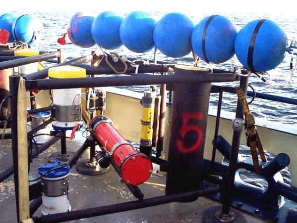
Figure 3. A tripod for the array set at
Sites 1-7 during OC339.
Also surface and sub-surface moorings were placed at Sites 2, 4, and 6 to provide temperature records throughout the water column. Data for the moorings in the array on the southern flank of Georges Bank are summarized in Table 1.
Table 1. Summary of information on the moorings set during OC339.
This is an array to study physical processes at the tidally mixed front on the southern flank of Georges Bank.
Site number |
Latitude N |
Longitude W |
Depth (m) |
Time (Z) |
Date |
|---|---|---|---|---|---|
1 tripod |
41 10.181 |
67 18.508 |
56 |
2031 |
19 March |
2 surface (A) |
41 08.700 |
67 17.702 |
60 |
1613 |
18 March |
2 sub-surface |
41 08.721 |
67 17.634 |
60 |
1921 |
18 March |
2 tripod |
41 08.656 |
67 17.737 |
59 |
1848 |
19 March |
3 tripod |
41 07.373 |
67 16.815 |
59 |
1757 |
19 March |
4 surface (L) |
41 06.559 |
67 16.212 |
61 |
1253 |
18 March |
4 sub-surface |
41 06.581 |
67 16.146 |
62 |
2158 |
18 March |
4 tripod |
41 06.505 |
67 16.285 |
61 |
1335 |
19 March |
5 tripod |
41 05.503 |
67 15.696 |
64 |
1630 |
19 March |
6 surface (F) |
41 04.274 |
67 14.896 |
66 |
1445 |
18 March |
6 sub-surface |
41 04.279 |
67 14.832 |
66 |
2348 |
18 March |
6 tripod |
41 04.248 |
67 14.958 |
66 |
1439 |
19 March |
7 tripod |
41 02.796 |
67 14.005 |
68 |
1531 |
19 March |
The second goal was the physical and biological characterization across the southern flank of Georges Bank emphasizing the area near the tidally mixed front. This was done through a series of CTD sections and MOCNESS hauls.
A number of temperature and salinity sections, including nutrients to be analyzed by D. Townsend, were completed along the moored array. The positions are shown in Figure 4.
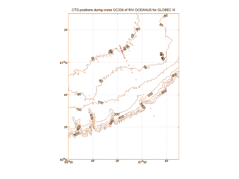
Figure 4A. Positions for CTD casts
completed during OC339: A. Stations in relation to the bathymetry
for the southern flank of Georges Bank.
B. Station positions and numbers for CTD casts.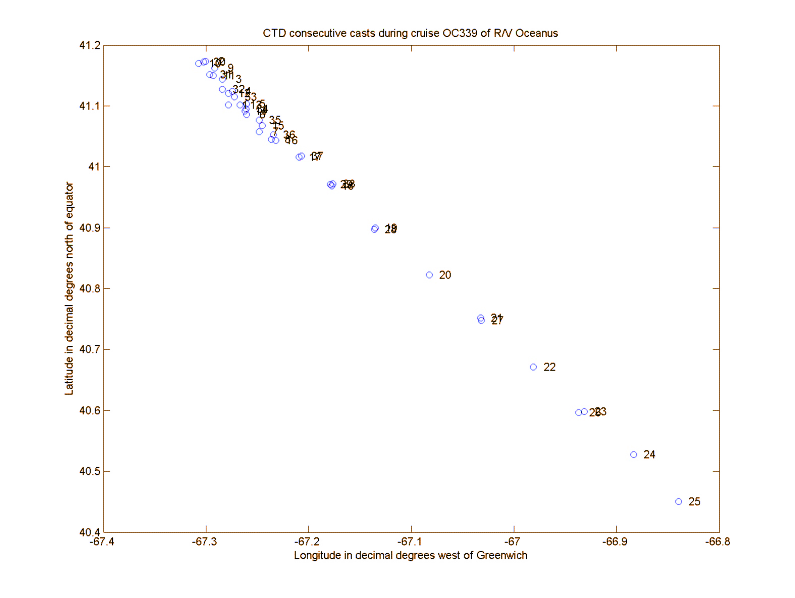
Figure 4B. Positions for CTD casts completed
during OC339:
The first section along the array, stations 2-8, clearly show the homogeneous character of the area (Figure 5). Temperature, salinity, and sigma-T varied over the ranges of 4.75-4.82 °C, 32.54-32.57 psu, and 25.75-25.78 kgm-3 respectively.
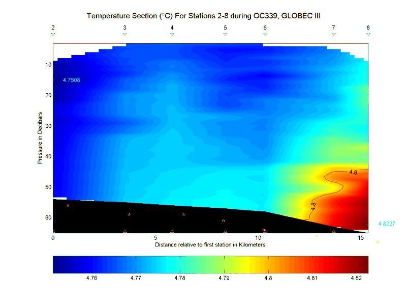
Figure 5A. CTD section for stations 2-8 during OC339, 17-25 March 1999.
The stars represent
the positions of the Sites 1-7 for the moored array as presented in Table 1: A.
Temperature in °C.
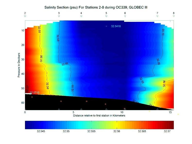
Figure 5B. CTD section for stations 2-8 during OC339, 17-25 March 1999.
The stars represent
the positions of the Sites 1-7 for the moored array as presented in Table 1: B. Salinity in psu.
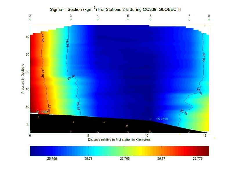
Figure 5C. CTD section for stations 2-8 during OC339, 17-25 March 1999.
The stars represent
the positions of the Sites 1-7 for the moored array as presented in Table 1:C.
Sigma-T in kgm-3.
The second section extended into a warm-core ring south of Georges Bank at the time (Figures 6 and 7).
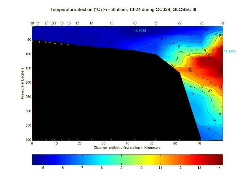
Figure 6A.
CTD section for stations 10-24 during OC339, 17-25 March 1999. The stars represent
the positions of the Sites 1-7 for the moored array as presented in Table 1: A.
Temperature in °C.
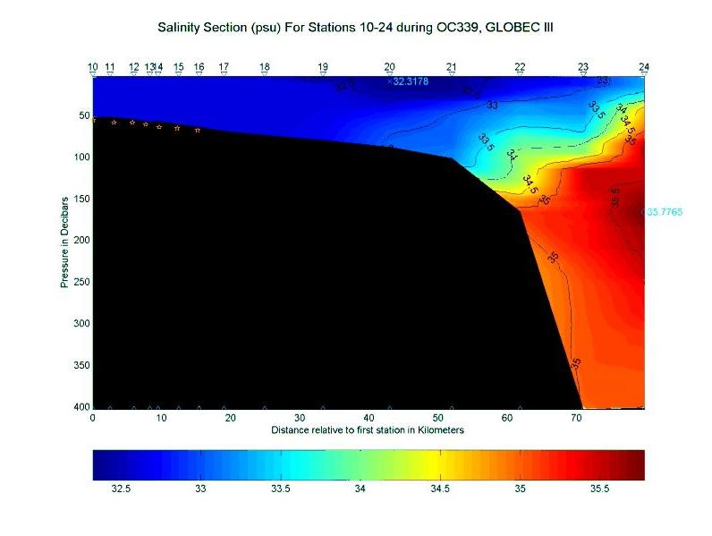
Figure 6B. CTD section for stations 10-24
during OC339, 17-25 March 1999. The stars represent
the positions of the Sites 1-7 for the moored array as presented in Table 1:B.
Salinity in psu.
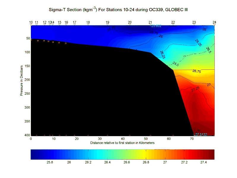
Figure 6C. CTD section for stations 10-24 during
OC339, 17-25 March 1999. The stars represent
the positions of the Sites 1-7 for the moored array as presented in
Table 1:C. Sigma-T in kgm-3.
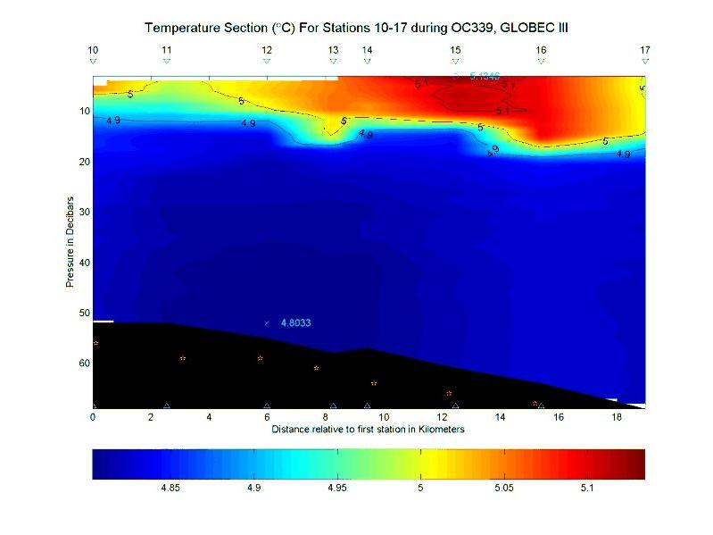
Figure 7A. CTD section for stations 10-17 during
OC339, 17-25 March 1999. The stars represent
the positions of the Sites 1-7 for the moored array as presented in Table 1: A.
Temperature in °C.
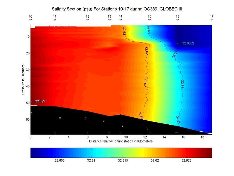
Figure 7B. CTD section for stations 10-17 during
OC339, 17-25 March 1999. The stars represent
the positions of the Sites 1-7 for the moored array as presented in Table 1:B.
Salinity in psu.
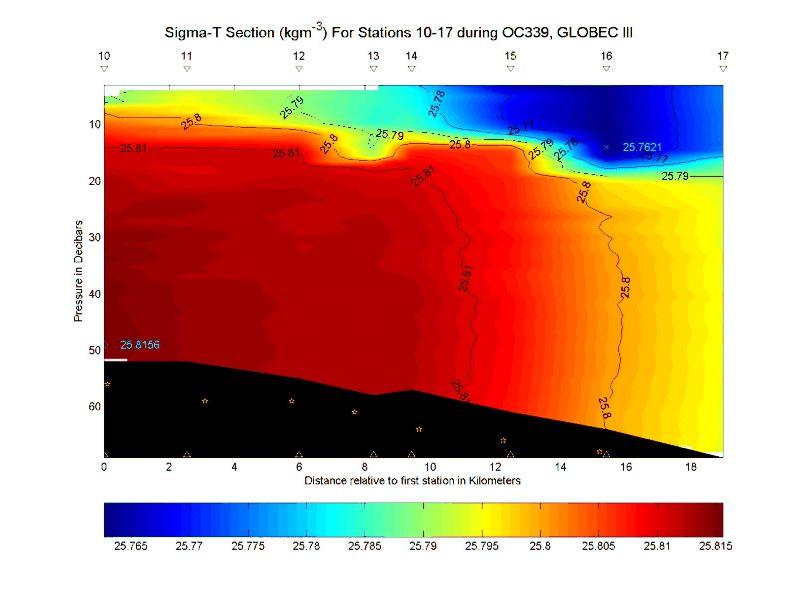
Figure 7C. CTD section for stations 10-17 during
OC339, 17-25 March 1999. The stars represent
the positions of the Sites 1-7 for the moored array as presented in Table 1: C.
Sigma-T in kgm-3.
Some weak temporary vertical structure caused by warming at the surface was seen along the array. Also possible modified overflow from the Scotian Shelf is seen at stations 20-21. In addition the structure of the warm-core ring is clear south of the continental shelfbreak. At this time near the array is unaffected by the presence of the ring. The section back onto the shelf after the storm, stations 25-29, again shows the ring (Figure 8). This section was terminated south of the array since conditions allowed MOCNESS tows to begin again.
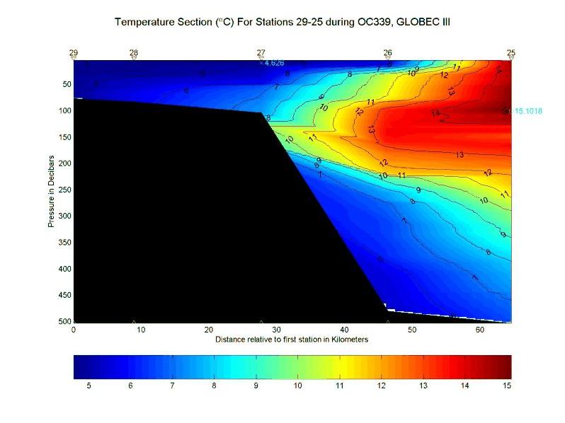
Figure 8A. CTD section for stations 25-29 during
OC339, 17-25 March 1999. The stars represent
the positions of the Sites 1-7 for the moored array as presented in Table 1: A.
Temperature in °C.
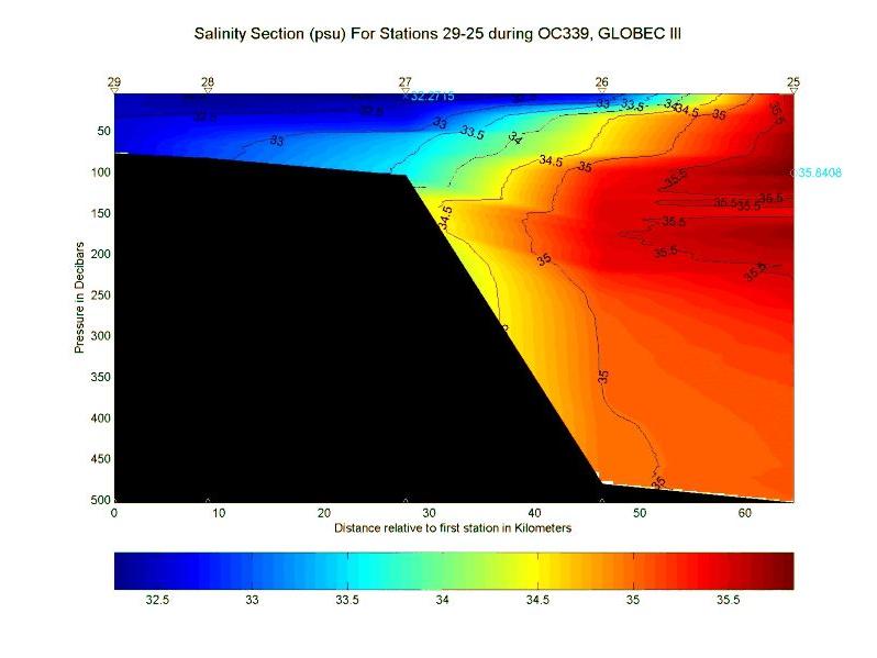
Figure 8B. CTD section for stations 25-29 during OC339, 17-25
March 1999. The stars represent
the positions of the Sites 1-7 for the moored array as presented in Table 1: B.
Salinity in psu.
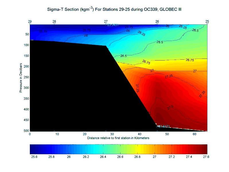
Figure 8C. CTD section for stations 25-29 during
OC339, 17-25 March 1999. The stars represent
the positions of the Sites 1-7 for the moored array as presented in Table 1: C.
Sigma-T in kgm-3.
The final section across the array, stations 30-38, showed an apparent intrusion of cooler fresher water just south of Site 7 (Figure 9). Conditions within the length of the array were similar to the previous section nothwithstanding the intervening storm.
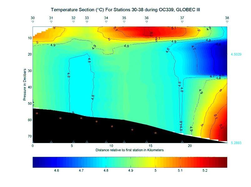
Figure 9A. CTD section for stations 30-38 during OC339, 17-25
March 1999. The stars represent
the positions of the Sites 1-7 for the moored array as presented in Table 1: A. Temperature
in °C.
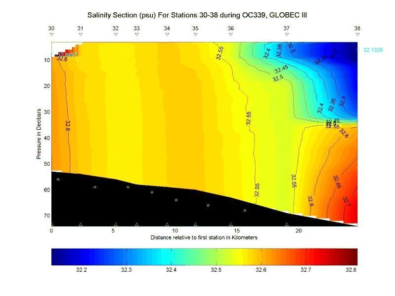
Figure 9B. CTD section for stations 30-38 during OC339, 17-25
March 1999. The stars represent
the positions of the Sites 1-7 for the moored array as presented in Table 1:B. Salinity
in psu.
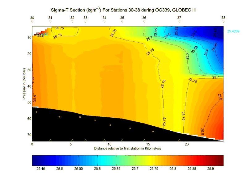
Figure 9C. CTD section for stations 30-38 during OC339, 17-25
March 1999. The stars represent
the positions of the Sites 1-7 for the moored array as presented in Table 1:C. Sigma-T
in kgm-3.
Ichthyoplankton-zooplankton studies during the cruise were managed and reported by R. G. Lough. These tows occurred mainly during night until the moorings were set. The 1-m2 MOCNESS with nine 0.333-mm mesh nets was used to sample larval fish and larger zooplankton. Sensors included light and fluoresence; the transmissometer was not working. A video Plankton Recorder (VPR) also was attached to the MOCNESS frame to record fine-scale zooplankton during the tow. This particular system was held in four underwater housings and consisted of two Hi-8 Video Camcorder interfaced with Tattletale Computer Software, a low (5.6x) and a high (72x) magnification cameras synchronized at 60 Hz with a xenon strobe, a Horita time-code generator and a 24V-8amp Gel battery pack. Operation was independent of MOCNESS. Recordings were downloaded to SVHS tape format. No image processing was done in real-time.
The 1/4-m2 MOCNESS with nine 0.064-mm nets was used to sample the smaller plankton such as copepod nauplii. The tow profile for these two nets was nominally 10-m strata within 5 m of the bottom; extra nets were used for special collections. The 1-m2 MOCNESS nets typically sampled for 5 minutes to filter about 250 m3 of water; the 1/4-m2 MOCNESS nets for 2-3 minutes to filter about 30-40 m3. Extra double-oblique net profiles from the 1-m2 MOCNESS of the entire water column were picked for larval cod and haddock. Samples were frozen in liquid nitrogen for biochemical analysis or preserved in alcohol for otolith analysis. Prior to freezing, larval fish were video taped with a Zeiss Stemi SV6 stereomicroscope rigged with an MTI CCD72 black and white video camera. Other larvae were measured to the nearest 0.01 mm SL using Optimas image analysis software connected to a Zeiss Stemi SV6 stereomicroscope, equipped with a Hitachi HV-C20 color video camera.
Along the mooring transect a total of 21 1-m2 MOCNESS tows were successfully made and two 1/4-m2 MOCNESS tows. Most of the tows were made of mooring sites 4 and 7 to compare the mid tidal front and more southerly sites where larval fish were present. Only two tows (MOC 173 & 191) were made at mooring site 1, the most shoal, where few larvae were caught. One tow was conducted south of mooring 7 at 80-m depth (MOC188). Only two 1/4-m2 MOCNESS tows (MOC 186 & 187) were made at sites 7 and 4. Cod larvae were most abundant and about 7 mm indicating hatch a few weeks previous. Recently-hatched yolksac haddock were observed at the most southerly sites > 70 m, suggesting a more midflank concentration. A total of 323 larval cod and 132 haddock were frozen for biochemical analysis ashore by E. Caldarone. For larval otolith analysis, a total of 179 cod were preserved in alcohol for D. Townsend and 10 haddock for B. Burns.
Table 2. Event log for OC339
4. Scientific Personnel on Cruise OC339
| Name | Title | Affiliation |
|---|---|---|
| Ronald Schlitz | Chief Scientist | NOAA/NMFS/NEFSC, Woods Hole, MA |
| R. Gregory Lough | Oceanographer | NOAA/NMFS/NEFSC, Woods Hole, MA |
| James Manning | Oceanographer | NOAA/NMFS/NEFSC, Woods Hole, MA |
| Elisabeth Broughton | Biological Technician | NOAA/NMFS/NEFSC, Woods Hole, MA |
| Antonie Chute | Biological Technician | NOAA/NMFS/NEFSC, Woods Hole, MA |
| Marie Kiladis | Biological Technician | NOAA/NMFS/NEFSC, Woods Hole, MA |
| Malinda Sutor | Biological Technician | University of Rhode Island, Kingston, RI |
| Keston Smith | Oceanographic Technician | PTSI, Norfolk, VA |
| Marinna Martini | Ocean Engineer | USGS Field Center, Woods Hole, MA |
| Jessica Cote | Ocean Engineer | USGS Field Center, Woods Hole, MA |
| Jonathan Bordon | Electronic Technician | USGS Field Center, Woods Hole, MA |
| Jason Hyatt | Oceanographer | USGS Field Center, Woods Hole, MA |
| Brian Guest | Engineering Assistant | WHOI, Woods Hole, MA |
| Jennifer Elliott | Student | Maine Maritime Academy, Castine, ME |
| Lisa DeSousa | Student | University of Rhode Island, Kingston, RI |