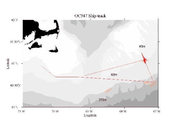
 Figure 1. Track for R/V OCEANUS Cruise 347 (OC347), 25-31 August 1999.
Acknowledgments
In spite of the early conclusion of the cruise due to Dennis, the probable menace, we accomplished much albeit the failure of a release on the tripod at Site 4. Recognition for much of the success during OC347 goes to all Officers and Crew who sailed on R/V OCEANUS. In particular, the Boatswain deserves special acknowledgment for adeptly and skillfully managing the deck. Also members of the scientific party deserve recognition for standing arduous 12-hour watches and then spending more time to ensure the success of the experiment.
This report was prepared by R. Schlitz with contributions from J. Manning, R. G. Lough, E. Broughton, and R. Gamble.
This research was sponsored by the NOAA Coastal Ocean Office under funding for the U. S. Global Ocean Ecosystem Dynamics Program Northwest Atlantic Field Studies, Phase III.
Table of Contents
List of Tables...................................................................................................................................3
List of Figures..................................................................................................................................4
1. Purpose of Cruise................................................................................................................5
2. Cruise Narrative..................................................................................................................5
3. Cruise Results......................................................................................................................8
4. Scientific Personnel on Cruise OC347..............................................................................9
List of Tables
Table 1. Summary of information on the moorings set during OC347..........................................10
Table 2. Event log for OC347.........................................................................................................11
List of Figures
Figure 1. Track for R/V OCEANUS Cruise 347 (OC347), 25-31 August 1999...........................13
Figure 2. Moored array recovered OC347. The positions for the array first set during OC339 are in red. The second setting during EL9906 is in black. A. The setting of the arrays in relation to the regional bathymetry for Georges Bank. B. The arrays in relation to the detailed bathymetry along the southern flank. These moorings are designated Sites 1-7 from North to South with particulars presented in Table 1..........................................................................................................................14
Figure 3. A tripod for the array recovered at Sites 1-3 and 5-7 during OC347.............................16
Figure 4. Positions for CTD casts completed during OC347. A. Stations in relation to the bathymetry for the southern flank of Georges Bank. B. Station positions and numbers for CTD casts...................................................................................................................................................17
Figure 5. CTD section for stations 1-8 during OC347, 25-31 August 1999. The stars represent the positions of the Sites 1-7 for the moored array as presented in Table 1. A. Temperature in °C. B. Salinity in psu. C. Sigma-T in kgm-3...............................................................................................19
Figure 6. CTD section for stations 9-17 during OC347, 25-31 August 1999. The stars represent the positions of the Sites 1-7 for the moored array as presented in Table 1. A. Temperature in °C. B. Salinity in psu. C. Sigma-T in kgm3................................................................................................22
Figure 7. CTD section for stations 21-29 during OC347, 25-31 August 1999. The stars represent the positions of the Sites 1-7 for the moored array as presented in Table 1. A. Temperature in °C. B. Salinity in psu. C. Sigma-T in kgm-3..........................................................................................25
Figure 8. CTD section for stations 30-39 during OC347, 25-31 August 1999. The stars represent the positions of the Sites 1-7 for the moored array as presented in Table 1. A. Temperature in °C. B. Salinity in psu. C. Sigma-T in kgm-3..........................................................................................28
Cruise Report
R/V Oceanus Cruise OC347
Woods Hole, MA to Woods Hole, MA
25-31 August 1999
1. Purpose of Cruise
This cruise had two major goals. The first was to recover a closely-spaced array of moorings at seven sites centered at the 60 m isobath on southern Georges Bank. The array was situated approximately perpendicular to the local topography spanning the historical location of the tidally mixed front. The second goal was to examine the abundance, distribution, and condition of ichthyoplankton along the array in relation to the hydrographic structure in late summer. OC347 was the final of three cruises following EL9906 in June 1999 and OC339 in March 1999. The overall GLOBEC goal is to focus on the physical processes that determine the circulation within the regime of the tidally mixed front on southern Georges Bank and associated dynamics of plankton.
2. Cruise Narrative
We left Woods Hole in light fog at 10:00 EDT on Wednesday 25 August, 1999 to recover the GLOBEC III array, run CTD sections with nutrients, and complete the biological sampling with MOCNESS samplers. The route was south of the Islands. Weather was good, slight seas and light wind. Our estimated time of arrival at the array was 03:30 EDT on 26 August. At that time we started with a MOCNESS (MOC1) haul at station 100, as on the previous cruise on board R/V EDWIN LINK (EL9906). We learned that the 300 mhz Broadband ADCP was not functioning; this was not good start. Also the 150 mhz Narrowband had an intermittent problem with one of the beams on the last trip. In addition the CTD winch was slipping at times but in deeper water; the Chief did not believe that there was a problem for the present work.
We arrived at station 100 for a MOC1 at about 03:00 EDT on 26 August 1999. There was a problem starting the program that controls the MOC1. The message said that communications could not be established. Some cables were changed on MOC1, then the program started and a haul was done beginning at ~05:00 EDT. We steamed toward Site 1 and started there once the samples from the MOC1 were taken and sampler was secured. The weather was good and forecast was good for the next couple of days with Dennis in the Bahamas, Cindy still in the tropical Atlantic, and Emily south of Dennis off South America. The 150 mhz ADCP seemed to be functioning correctly. Jim Manning reported seeing 6 lights of buoys during the night. At Site 1 the release on the tripod was interrogated and responded. At about 07:30 EDT recovery of the surface buoy at Site 1 started. It was on board with anchor at 08:00 EDT. Then the surface marker was moved to the 0-1 deck to clear space in good conditions. The tripod was released and the balls came to the surface. They were not dragging much and were lying flat. The tripod was recovered by 09:15 EDT. This was one of the old releases and functioned just fine. We were off to the next recovery at site 2, leaving at 09:25 EDT. The sub-surface mooring at Site 2 with Vemco thermisters and the surface buoy at Site 2 were recovered by 10:30 EDT, without incident. Then time was taken to move some sub-surface floats and the second surface buoy to the 0-1 deck. The tripod at site 2 was recovered without incident at 11:40 EDT. We moved on to Site 3 where the surface float and tripod were recovered without incident by 14:50 EDT. Marinna wanted to jump to Sites 5 and 7 for remainder of the day, since there were new releases at Sites 4 and 6 which could have required more work. At 16:55 EDT we recovered the surface float and tripod from Site 5. Next was Site 7 which was the last mooring work for the day. When we arrived at Site 7, a decision was made to delay the recoveries until the next day for safety due to fatigue. Before quitting, communication was established with the tripod which reported horizontal. Triangulation was done to establish that the tripod was in the same position as set. The work for the night was a CTD section along the line of the array then MOC1 at a position to be determined.
Overnight there were 8 CTD stations done, at Sites 1-7 and north of Site 1 since the front was not completely resolved at Site 1. There was a problem in that CTDs stopped ~5 m short since the position of the transducer was not added to the depth readings. An altimeter was not on the CTD frame. Two MOC 1 tows were done at station 100, the same position as on EL9906. At 07:00 EDT on 27 August 1999 the mooring work for the day started at Site 7 in fog that was lightening and lifting. The surface buoy was recovered by 07:30 EDT before breakfast. Tropical fish were at the stern, temperature was at 19.7 °C, and salinity was 32.7 psu. The tripod at Site 7 was recovered in fog at 08:30 EDT. The floats came directly to the surface and the tripod gave no signs that it was on its side as the release had reported. The fog was a little heavier now. We moved on to Site 6 for recovery. The sub-surface array, with two balls and a Dacron line spliced-in for wire rope, was recovered at 09:20 EDT but fog made work marginal according to the Master. The surface buoy was recovered without incident at 10:00 EDT. The tripod was enabled, a range was taken, and then released with confirmation. The balls did not appear at the surface, even though visibility improved as the fog thinned. The release was disabled and then we steamed to Site 4 for the final recovery before we contemplated options, including dragging. At site 4 the surface buoy was recovered first due to the direction of the current, without incident at 11:10 EDT. The deck, which was now crowded, was secured before lunch. After that the remaining pieces at Site 4 were to be recovered. The sub-surface mooring at Site 4 was recovered at 13:00 EDT. The tripod at Site 4 was released but not seen at the surface. At the same time fog returned to lower visibility. The deck was secured and then rigging for dragging at Site 4 was completed. Dragging began at about 14:15 EDT. These were straight-line drags with the intention of hitting the tripod but not severing the line if the balls were released upon impact. If not recovered by turn of the watch we would complete CTD startion and MOCNESS tows during the night. The plan was MOC1 at station 100, then a CTD section, south to north, extending farther to the north than the array, then a series of MOC1s followed by a short series of CTDs to define the local regime.
During the night there was a MOC1 at station 100, a CTD section that ran into shallower water to resolve the front, and an additional short CTD section crossing the MOC1 position at station 100. We then went to Site 6 and to see if the balls had come to the surface overnight. Seeing no flotation we then moved to Site 4. Dragging began at 07:15 EDT on 28 August 1999 in a linear pattern to attempt hitting the tripod and releasing the balls. After breakfast we stopped dragging for a while to remove equipment from the tripods so that downloading of data could begin. The Master had problems with the linear method of dragging, preferring “the noose method”. However, the experience from 1997 was that the line with flotation was cut by the noose making recovery all that more difficult. In the interim a MOC1 was completed at 10:00 EDT. At about 10:30 EDT there was a problem in the generator room that would not allow the trawl winch to be used for at least two hours. We steamed to Site 6 but there were no balls at the surface. The Chief thought that repairs would be done at about 13:30 EDT. We therefore would begin a MOC1 tow at station 100 at 12:30 EDT before going back to dragging. At completion of MOC1, around 13:40 EDT, we were told that the problem in the generator room was fixed and that dragging was possible again. We headed for Site 4 to commence again. We decided to use a new tactic, laying the wire perpendicular to the current upstream of the tripod and then drifting the wire across the tripod. Two tows were not successful; the first as just above and the second using the noose. The tension on the line during the noose was high enough to indicate something on the hook, but it was not the case. This ended at 20:15 EDT. We would then return to station 100 for a MOC1, a CTD section, followed by either another MOC1 followed by a short CTD section, or a ADCP run followed by a MOC1.
During the night there were two MOC1 tows at station 100, one at the beginning of the evening and one at the end, just at daylight. There was also a CTD section. At 07:00 on 29 August 1999 we were at Site 4 to triangulate on the tripod. There were no balls at the surface. The seas were up for the first time in the cruise and the weather forecast was for ~25 kt NE winds on Monday. Triangulation was completed at Site 4. There was no indication that the tripod had moved. Then we steamed to Site 6 where triangulation was done and dragging started. At 10:10 EDT the balls were at the surface. Haulback of the dragging line stopped and the ship turned away from the tripod so as to prevent the line from the flotation to the tripod from being severed. Preparations were started for recovery. At about 10:50 EDT the tripod at site 6 was recovered without further problems. The release pin had not retracted. It appeared as if the drag wire caught one end of the flotation and ripped the entire flotation assembly free from the tripod, somehow without parting the line. We were going back to site 4 to try again. It was noted that after about 15 min. on deck the release pin retracted spontaneously! Dragging today at site 4 was unsuccessful. Overnight there would be a MOC1 at station 100, a CTD section that goes an additional station to the north from the prior sections, and a second MOC1. We now has to contend with the possibility that hurricane Dennis would cause us to leave the area. On the evening of 29 August 1999 he was heading north at 11 kt located at 31.5°N and 78.3°W, about 120 nm SE of Savannah. He was expected to pass just east of Cape Hatteras which then projected a track to us, unless there was more curving toward the east.
Overnight there was a MOC1 tow, a CTD section extending a little further toward the north, a second MOC1 haul, and finally an ADCP section from station 100, about the same position as Site 4 toward Site 1 and back. However in the prior 4-6 hours the wind had increased to 12-14 ms-1 and backed to NE. So the work other than dragging on 30 August 1999 was problematic. The first drag was not successful and it was difficult to keep course due to wind, sea, and the fact that the winch could not pay out at a speed greater than 40 mmin-1. We would try one more drag, which would be the last until the conditions improved. Also the Master was concerned about the course of Dennis after tomorrow noon when the predicted position was NE of Cape Hatteras. At noon, the Master had decided that we would leave the area after one last attempt, based on the latest weather forecast for Dennis. We left Site 4 after checking the tripod for proper attitude at ~14:40 EDT. We then went north beyond the end of the mooring line and started an ADCP section at 15:30 EDT along the line to the 200 m isobath, ending at 19:30 EDT. After the ADCP section was completed we changed course toward Asia Rip. The Captain decided to forgo the Pickart section across the shelfbreak south of Nantucket and head directly toward the west.
At 07:30 EDT on 31 August 1999 the Master decided that we would continue to Woods Hole since the weather forecast for Dennis was so uncertain. This effectively ended this cruise due to the transit times to and from the area on Georges Bank where we were working. The way to get the tripod at Site 4 remained unclear. We arrived in Woods Hole at 14:30 EDT.
3. Cruise Results
There were two primary goals for OC347. The first was to recover a closely-spaced linear array of seven moorings centered at 60 m (Figure 2) designed to examine the circulation and hydrography, thermal structure in particular, at the tidally mixed front on the southern flank of Georges Bank. This was successful, save the tripod at Site 4, but not routine as seen from the cruise narrative above. The major system for scientific sampling at each location a tripod placed on the bottom with an upward-looking ADCP (Figure 3) that resolved the currents within the water column at 1 m intervals. Added to the tripod were temperature, salinity, and pressure recorders. Also surface and sub-surface moorings were placed at Sites 2, 4, and 6 to provide temperature records throughout the water column. Information about the moorings in the array during the second setting on the southern flank of Georges Bank are summarized in Table 1.
The second goal was the physical and biological characterization across the southern flank of Georges Bank emphasizing the area near the tidally mixed front. This was done through a series of CTD sections, MOCNESS hauls, and ADCP sections which were delivered as part of the overall processing of ADCP data for the GLOBEC experiments by C. Flagg..
A number of temperature and salinity sections, including nutrients to be analyzed by D. Townsend, were completed along the moored array. The positions are shown in Figure 4. When taken as a whole three main oceanographic features emerged from the CTD sections (Figures 5-8). The first was the is the mature development of the seasonal thermocline between 10 m and 20 m, with surface temperatures ~20° C - 21° C. The second was the clear delineation of the northern extent of the cold band. Temperatures ~11° C - 12° C and salinities ~32.8 PSU were sampled at the southern ends of the sections near the bottom. The third showed that the tidally mixed front located near Site 4 in June had migrated toward shallower water and was now found near or north of Site 1.
Ichthyoplankton-zooplankton studies during the cruise were managed and reported by R. G. Lough. The 1-m2 MOCNESS with nine 0.333-mm mesh nets was used to sample larval fish and larger zooplankton. Sensors included light and fluoresence; the transmissometer was not working. A video Plankton Recorder (VPR) also was attached to the MOCNESS frame to record fine-scale zooplankton during the tow. This particular system was held in four underwater housings and consisted of two Hi-8 Video Camcorder interfaced with Tattletale Computer Software, a low (5.6x) and a high (72x) magnification cameras synchronized at 60 Hz with a xenon strobe, a Horita time-code generator and a 24V-8amp Gel battery pack. Operation was independent of MOCNESS. Recordings were downloaded to SVHS tape format. No image processing was done in real-time. At the mooring transect station 100, a total of 12 1-m2 MOCNESS tows were successfully made. No special collections were made.
4. Scientific Personnel on Cruise OC347
Name Title Affiliation
Ronald Schlitz Chief Scientist NOAA/NMFS/NEFSC, Woods Hole, MA
R. Gregory Lough Oceanographer NOAA/NMFS/NEFSC, Woods Hole, MA
James Manning Oceanographer NOAA/NMFS/NEFSC, Woods Hole, MA
Elisabeth Broughton Biological Technician NOAA/NMFS/NEFSC, Woods Hole, MA
Antonie Chute Biological Technician NOAA/NMFS/NEFSC, Woods Hole, MA
Marie Kiladis Biological Technician NOAA/NMFS/NEFSC, Woods Hole, MA
Keston Smith Oceanographic Technician PTSI, Norfolk, VA
Marinna Martini Ocean Engineer USGS Field Center, Woods Hole, MA
Jessica Cote Ocean Engineer USGS Field Center, Woods Hole, MA Jonathan Borden Electronic Technician USGS Field Center, Woods Hole, MA
Richard Rendigs Geologist USGS Field Center, Woods Hole, MA
Brian Guest Engineering Assistant WHOI, Woods Hole, MA
Jennifer Skelly Student University of Rhode Island, Kingston, RI
Joseph Cofone Student University of Rhode Island, Kingston, RI
William Flynn Student University of Massachusetts,Boston,MA
Natasha Watson Student University of Maine, Orono, ME
Table 1. Summary of information on the moorings recovered during OC347. This was an array to study physical processes at the tidally mixed front on the southern flank of Georges Bank.
Site number Latitude N Longitude W Depth (m) Time (Z) Date recovered
11 surface (E) 41 08.79 67 26.54 57 1138 26 August
11 tripod 41 08.83 67 26.54 57 1305 26 August
21 surface (L) 41 07.20 67 25.75 58 1430 26 August
21 sub-surface 41 07.24 67 25.73 58 1355 26 August
21 tripod 41 07.17 67 25.80 58 1529 26August
31 surface (B) 41 05.91 67 24.99 59 1729 26 August
31 tripod 41 05.89 67 25.01 59 1845 26 August
41 surface (A) 41 04.95 67 24.56 60 1511 27 August
41 sub-surface 41 04.86 67 24.59 60 1657 27 August
41 tripod* 41 04.98 67 24.51 60 ---- ---------
51 surface (D) 41 03.95 67 23.99 63 1949 26 August
51 tripod 41 03.87 67 24.09 61 2051 26 August
61 surface (F) 41 02.68 67 23.35 63 1404 27 August
61 sub-surface 41 02.67 67 23.29 64 1320 27 August
61 tripod 41 02.60 67 23.41 64 1451 29 August
71 surface (J) 41 00.40 67 22.82 68 1128 27 August
71 tripod 41 00.43 67 22.90 68 1236 27 August
* This tripod as not recovered during OC347 due to release failure.
Table 2. Event log for EL9906
Figure 1. Track for R/V OCEANUS Cruise 347 (OC347), 25-31 August 1999.
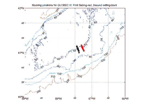 Figure 2. Moored array recovered OC347. The positions for the array first set during OC339
are in red. The second setting during EL9906 is in black.
Figure 2. Moored array recovered OC347. The positions for the array first set during OC339
are in red. The second setting during EL9906 is in black.A. The setting of the arrays in relation to the regional bathymetry for Georges Bank.