
Figure 1 a Mooring sites, and CTD positions for C.S.S. Parizeau Voyage
98-078, 10-16 February 1999
NOTE: Some tables still need reformatting for Web.
Currently may display better
under Internet Explorer than under Netscape. (DWS, 2 Oct 2000.)
******************************************************************************
REPORT ON C.C.G.S. Parizeau
CRUISE 98-078
10-16 February 1999
by
Peter C. Smith and Gary L.
Bugden
Ocean Sciences Division
Bedford Institute of
Oceanography Dartmouth, Nova Scotia
and
Jackie Spry
Sprytech Biological
Services, Inc.
CANADA
March, 1999
BEDFORD INSTITUTE OF OCEANOGRAPHY CRUISE REPORT Parizeau 98-078
Local Cruise Designation: 98-078
Vessel: C.C.G.S.
Parizeau
Dates: 10-16
February 1999
Area: Southwest
Nova Scotia / Georges Bank
Responsible Agency: Ocean
Sciences Division
Maritimes
Region, DFO
Ship's Master: Capt.
W. English
Scientific Personnel:
P.C. Smith Ocean
Sciences
M. Scotney Ocean
Sciences
G. Bugden Ocean
Sciences
R. Boyce Ocean
Sciences
R. Ryan Ocean
Sciences
J. Spry Sprytech
Biological Services, Inc.
1. PURPOSE
The scientific objectives of this voyage were:
1.
Obtain
real-time measurements of surface (1 m) temperature and salinity over the
eastern flank of Georges Bank in order to monitor for cross-over events from
Browns to Georges,
2.
Determine
the distribution of temperature, salinity, nutrients and biota in the vicinity
of SWNS and eastern Georges Bank,
3.
Acquire
Lagrangian measures of surface drift on Browns and eastern Georges Banks.
The activities planned for
the cruise period include:
1.
Deploy
a sentinel guard buoy mooring carrying an ARGOS transmitter to relay data from
a 1-m SeaCat at the NECW site in western Northeast Channel (Figure 1a),
2.
Conduct
CTD survey of SWNS and eastern Georges Bank,
3.
Make
a series of biological measurements on Browns, Georges and offshore,
4.
Conduct
monitoring activities at Halifax Line Station #2.
2. NATURE OF
DATA GATHERED
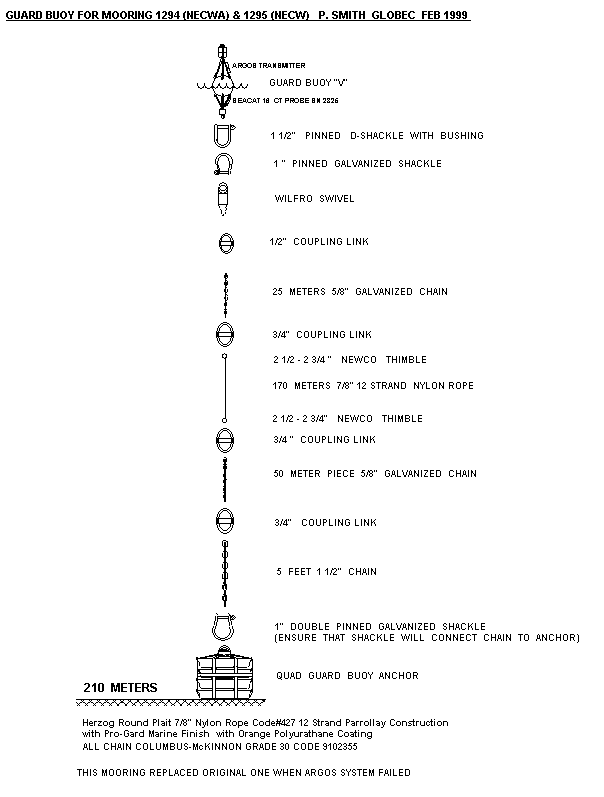
A single mooring (Guard Buoy
“V”; Table 1) was deployed during this voyage at the NECW mooring site on the
eastern side of Northeast Channel. The
buoy, equipped with a SeaCat T,S recorder at 1 m and an ARGOS beacon to
transmit data ashore, replaces the original sentinel mooring which failed due
to water in the battery compartment.
A total of 57 CTD stations
(Fig.1a, Table 2) were occupied at the mooring sites, primarily along the
following sections:
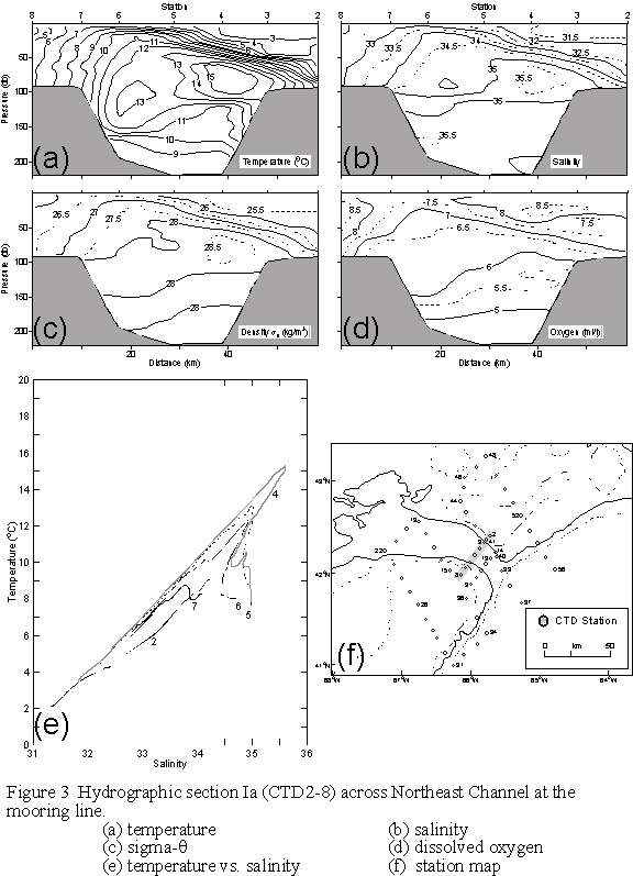
1) Section Ia - across Northeast
Channel from Browns to Georges Bank on
the mooring line, i.e. near the sill (Fig.3),
2) Section Ib - across Northeast
Channel from Browns to Georges Bank
south of the mooring line, i.e. toward the mouth (Fig.4),
3)
Section
II - across the eastern portion of Georges Bank proper (Fig.5),
4)
Section
III - across the eastern tip of Georges Bank, i.e. along the western side of
Northeast Channel (Fig.6)
5) Section IV - across the western
edge of Browns Bank, i.e. along the eastern side of Northeast Channel (Fig.7),
and
6) Section
V - across the western Scotian Shelf off Cape Sable (Fig.8).
The quality of the CTD
salinity measurements is quite acceptable (Table 3a). The YSI dissolved oxygen
sensor was calibrated to match surface saturation conditions at the temperature
and salinity measured there by the CTD (Table 3b, Figure 2a). The YSI oxygen sensor membrane was replaced
after CTD1 as it was found to be ruptured.
No further problems were encountered with this sensor.
Biological measurements were
taken at a total of 12 stations in the southwest Nova Scotia-Georges Bank area
(Table 4a) and the Halifax Line Station 2 monitoring site was occupied on both
departure and return (Table 4b).
Nutrient, chlorophyll and salinity samples were variously drawn at
roughly standard depths, and plankton samples were taken with double-oblique
bongo hauls to 50 m in shallow water (<100m) or a vertical ring net cast in
deeper regions. Samples from one of the
bongo nets was preserved in formalin; samples from the other were preserved in
alcohol for genetic analysis at Dalhousie University. (Chris Taggart).
Near surface sampling of
temperature, salinity, chlorophyll fluorescence, and solar radiation (PAR) was
undertaken along the ship’s track using Biological Oceanography’s flow-through
system. Except for occasional computer
crashes and periods of high noise during rough weather, this system provided
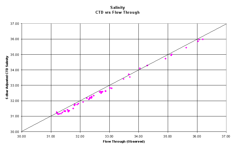
continuous surface data over the entire voyage. The calibration of the flow-through measurements against surface
values from the CTD show some offsets (Fig.2b and 3b, Table 3c)
For the Lagrangian
experiment, a total of five WOCE drifters with drogues at 10 m were placed in
areas off Georges Bank (Table 5). The
first three were deployed in a line across the eastern edge of a warm core eddy
which had penetrated into the mouth of Northeast Channel. The remaining two drifters were place along
the northern flank of Georges to monitor possible flows from the interior Gulf
onto the Bank.
3. PROGRAM
SUMMARY
Date From (Z) To
(Z) Operation
10 Feb. 2100 0230(11) Depart BIO enroute to Hlfx Stn 2 monitoring site
11 Feb. 0230 0400 Conduct monitoring protocol at Hlfx Stn.2, CTD1
2200 0400(12) CTD2-8 on Section Ia
12 Feb. 0530 1100 CTD9-14 on Section Ib; deploy 3 drifters
1300 1400 Mooring placement operations at NECW
1450 2150 CTD15-19 on Section III, biological sampling
2250 0220(13) CTD20,21; deploy 2 drifters
13 Feb. 0230 1900 CTD22-31 on Section II, biological sampling
1950 2200 CTD32,33
2315 0445(14) CTD34-36 on Section III, biological sampling
14 Feb. 0815 2349 CTD37-45 on Section IV, biological sampling
15 Feb. 0036 0205 CTD46,47 toward Cape Sable
0311 1536 CTD48-56 on Section V
1023 1125 CTD57, biological sampling at Hlfx Stn 2
16 Feb. 1500 Arrive BIO
4. MOORING OPERATIONS
After a delay by foul
weather and seas on 10 Feb., the single mooring operation at NECW proceeded
largely without incident (Table 1 a,b).
On the way to the site, a large wave had broken across the foredeck,
loosening the bindings on the guard buoy, but there was no apparent damage to
the instruments attached to it. The
mooring was placed precisely at the same location as the earlier version, whose
instruments had failed, so there was no need for a notice to mariners.
5.
HYDROGRAPHIC/BIOLOGICAL MEASUREMENTS
Hydrographic measurements,
including dissolved oxygen and fluorescence, were made at a total of 57
stations (Table 2) using a Seabird 25 portable CTD system, equipped with a SBE
23Y Yellow Springs Instruments (YSI) dissolved oxygen sensor, a PAR sensor and
a SeaTech fluorometer. The data were
recorded internally and downloaded periodically to a laptop PC which processed
them into ODF files.
In addition, biological
measurements, including 1) double-oblique Bongo casts to 50 m in shoal waters
(<100m); 2) ringnet casts to the bottom in deeper waters (>100m), and 3)
bottle casts for nutrient, chlorophyll, and salinity samples (see Table
4a,b.). The bottle casts generally took
samples at some subset of standard
depths (1, 30, 50, 70, 100, 150, 200, 300m).
All of this work was performed with the hydro winch, because of the
inability (due to the PSAC strike) to load the necessary winches and cranes for
the VOPC and MVP instruments.
The surface properties of
the ocean (T, S, chlorophyll, solar radiation, and nutrients) were monitored
underway using Biological Oceanography’s flow through system. This system encountered some problems
because of seawater pressure fluctuations associated with the rolling of the
ship and loss of suction when the bow was out of the water. This caused a lot of spikes in the signals,
especially the salinity. Biological
fouling of the seawater intake by mussels also caused unpredictable variations
in flow rate. The system computer
crashed on several occasions for some unknown reason(s), resulting in the loss
of several hours of data in each case.
Otherwise the system performed well.
Because of the passage of the seawater line through the ship, the
temperatures recorded by the flow-through system tended to be a bit higher
(~0.5oC) than those surface values from the SeaBird (Fig.2b; Table
3c).
The portable SeaBird system
worked well throughout the cruise, with the minor exception that some water was
intermittently found inside the battery case.
This did not seem to hamper the operations, however.
Problems/Recommendations:
1.
Better pumping for the
flow-through surface sampling system is required. Also, the electronics for the system should be trouble shot for
greater stand-alone reliability.
2.
Return SBE-25 to factory for
repair before serious damage is done by the leak.
5a. Processing
The data from the portable SeaBird system were downloaded to a laptop computer after every 3-4 stations, and then processed into ODF files for archiving. The following is a summary of the processing procedure:
1) Convert raw frequency data to binary pressure, temperature, conductivity, etc. using SEABIRD's DATCNV program.
2) Align downcast pressure, temperature and conductivity using SEABIRD's ALIGNCTD program by advancing the conductivity signal by 0.073 sec. Also advance oxygen temperature and oxygen sensor current by 3 seconds.
3)
Filter
downcast pressure using SEABIRD's FILTER program. This is a low pass filter and
we used a time constant of 0.5 seconds.
4)
Mark
downcast scans where the CTD is moving less than the minimum velocity of 0.01
m/s using SEABIRD's LOOPEDIT program.
5)
Compute
salinity and dissolved oxygen in ml/l using SEABIRD's DERIVE temperature
6)
Produce
screen plots of salinity, temperature and dissolved oxygen vs. pressure for
initial evaluation of data quality using SEAPLOT program.
7)
Produce
screen plots of PAR and chlorophyll fluorescence vs. pressure for initial
evaluation of data quality using SEAPLOT program.
8)
Bin
average downcast data to 0.5-dbar intervals using SEABIRD's BINAVG program.
9)
Convert
the down cast from binary to ASCII using SEABIRD's TRANS program.
10)
Convert
downcast to ODF format using OSD program SEAODF25.
11)
Create
IGOSS message using OSD program ODF_IGOS.
Plots and status info
displayed during the acquisition are discarded when the program
terminates. Plots of T, S, O2,
and sq vs. pressure and T vs. S were produced from the processed data
using SEABIRD’s SEAPLOT program as time permitted. Section plots were produced with Igor Yakashev’s contour package,
modified to compute sq and to accept .ODF files.
5b. Calibration
Because of the nature of
this operation (“rapid response”) and difficulties with loading associated with
the PSAC strike, the usual calibration standards were not maintained for this
mission. Nevertheless, a 1.2-liter
bottle was tripped at the bottom of selected CTD casts and a single salinity
sample was drawn to be analyzed at BIO (Table 3a). Similarly, selected salinity samples were drawn from the flow-through
system to assess its performance (Table 3a).
The flow-through properties were also compared to the near-surface CTD
measurements (Fig.2b, 2c; Table 3c).
The offset of the temperature regression was negative and the slope
significantly greater than one, because the coldest intake waters received the
most heat from the ship. The slope of
the salinity regression was not significantly different from one, so only a
simple offset is quoted for calibration purposes. In addition, duplicate nutrient samples were taken from the
Nisken bottles to analyze the accuracy of replicates (Data not shown
here). Finally, although there were no
dissolved oxygen samples taken, the general accuracy of the YSI sensor was
assessed by assuming that the surface values are saturated (Fig.3b). The O2 traces still showed
substantial hysteresis. The fluorometer
output voltage was fitted to extracted Chl-a values from the almost coincident
bottle casts. Results are shown in
Table 3d.
Problems/Recommendations:
(1) Efforts should be made to remove
the hysteresis between the up and down traces and occasional spiking at steep
temperature gradients from the YSI sensor output by application of filters and
various time lags.
5c. Sections
CTD sections Ia,b, II, III,
IV, and V (Figs. 3-8) depict hydrographic conditions, 1) across the sill in
Northeast Channel, 2) across Northeast Channel roughly 10 km seaward of the
sill, 3) across the eastern half of the Bank proper, 4) across the eastern peak
of the Bank, extending both offshore and into Georges Basin, 5) along the
western edge of Browns Bank, and 6) across the western Scotian Shelf off Cape
Sable, respectively. Section Ia (Fig.3)
shows two temperature maxima in Northeast Channel, with T>15oC at
depths of 50-100m on the eastern side and T>13oC at 80-120m on
the west. The salinity section suggests
that the eastern maximum, with levels in excess of 35.5, is derived from a Warm
Core Ring (WCR) or the Gulf Stream. Salinities
on the western side barely exceed 35, but may represent a diluted product from
the same source(s). Near the surface,
colder, fresher waters are found over each of the Banks, with T<3oC(5oC)
in the top 20 m over Browns(Georges), respectively. The low surface salinities over Browns (S<31.5) identify this
layer as Scotian Shelf water, whereas the higher salinities over Georges
(32<S<33) are characteristic for that Bank. The deep waters (>100m) on this section show S<35 and
temperatures of 8<T<10oC.
The T-S plots show interleaving between this water mass and the warm,
saline slope water above. The former
appears to be a diluted form of Labrador Slope Water (T~7-8oC;
34.5<S<35); the latter may be identified as Warm Slope Water (T~15oC,
S~35.5) The density section (Fig.3c)
reveals that the water over Browns is much more highly stratified due to the
intrusion of slope water beneath the cold, fresh surface layer. Furthermore, the sloping isopycnals suggest
a strong vertical shear on the east, which may be reversed in the deep layers
as the isopycnals slope in the opposite direction there. As expected, the dissolved oxygen section
shows high values (>8 ml/l) in the surface layers, but generally reduced
levels in the intrusion waters.
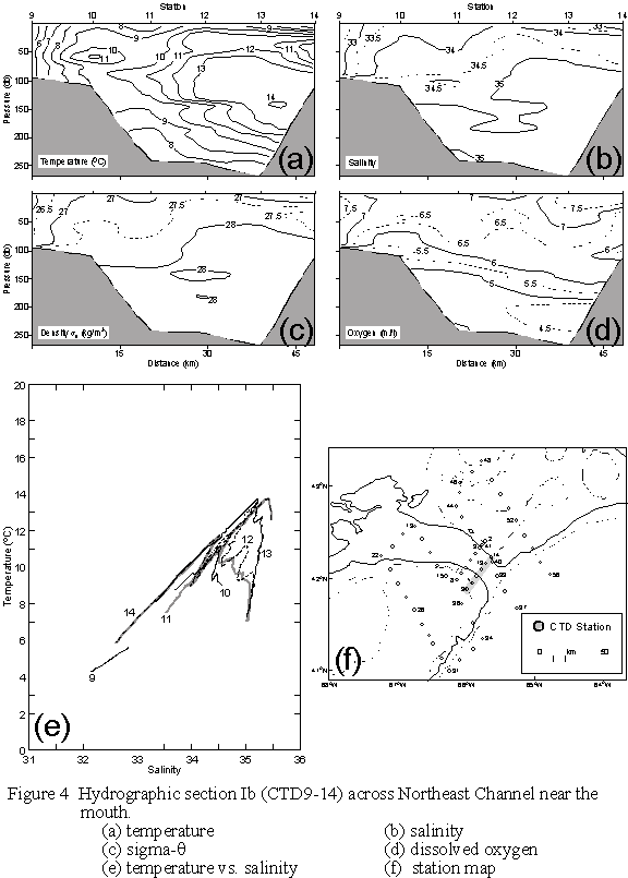
On Section Ib (Fig.4), the
distribution of high temperatures is much more pervasive than on Ia, both in
the NEC and on the Banks. The cold
surface layers have virtually disappeared and warm conditions (10-11oC)
prevail at depths of 30-50m, although the extreme temperature maximum (T>15oC)
on Ia is also absent. The minimum
surface salinities (32.5-33.0) indicate that Scotian Shelf water is not to be
found in this part of the NEC. The
density section shows less stratification than on Ia, but also shows some
static instabilities that need to be checked (e.g. at CTD14). Again the T-S plots indicate interleaving
between Labrador and Warm Slope Waters at CTD10-12.
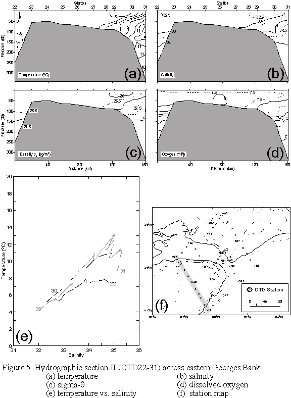
Section II (Fig.5) across
east-central Georges Bank indicates very little contrast in water properties
(5<T<6oC; 32.5<S<33) over the Bank, except near the
shelf break front where the water stratifies.
There is also a region of low surface salinity (<32.5) near CTD29-30,
which may represent diluted Scotian Shelf water that contributes to the
stratification on the SE flank. The T-S
plot indicates the presence of the two deep water types: Labrador Shelf Water
(T~7-8oC; 34.5<S<35) and Warm Slope Water (T~15oC,
S~35.5). The former is found in Georges
Basin (CTD22) while the latter seems to prevail offshore (CTD30-31) but with
evidence for strong interleaving. The
oxygen section shows a strange maximum at CTD26, but otherwise is reasonably
well mixed over the Bank with surface values in excess of 7.5 ml/l.
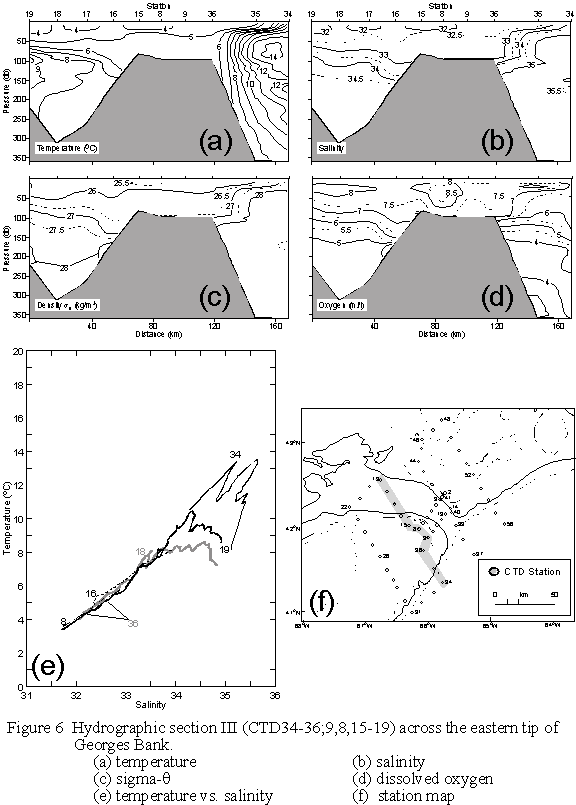
Section III (Fig.6) clearly
shows the proximity to the Bank of a warm, saline WCR or Gulf Stream feature
which is overlain by a cold fresh surface layer. Pockets of cold, fresh water (T<4oC, S<32) found
near the surface (depth<30m) at CTD8,15,17, and 19 may be undiluted versions
of Scotian Shelf Water arriving at the eastern tip of the Bank. The lightest water on the section is found
at CTD8,15. However, most of the
section over the Bank is composed of Georges Bank water (32<S<33). A sharp transition in the surface properties
occurs between CTD34 and 35, and again the contrast between the two types of
slope water is evident in the T-S plot.
In particular, there appears to be evidence for Warm Slope Water at
CTD18,19, but not so at CTD15. The
maximum deep salinities in Georges Basin (34.5<S<35.0) and offshore
(>35.5) create a density contrast between the two regions at depths of
50-200 m, which may be, in part, responsible for driving the intrusion through
NEC.
Conditions on Section IV
(Fig.7) show that the Gulf Stream/WCR water has encroached well onto the shelf
on the eastern side of NEC. A sharp
front in temperature, salinity and density between coastal (2<T<5oC,
S<31.5) and offshore (T>15oC, S>35.5) waters lies between
CTD41-42 on outer Browns Bank. The T-S
plot shows evidence for exceptionally strong interleaving in multiple layers at
CTD 41, and Warm Slope Waters with salinities and temperatures in excess of 36
and 16oC, respectively, at CTD37, just off the mouth of the
NEC. Over inner Browns, the salinity
rises to >32 throughout the water column, suggesting that its origin may be
to the west rather than the east, or it has somehow been diluted by offshore
waters. Again the T-S plot indicates
that the Scotian Shelf source waters are found inshore at CTD48. Surface oxygens are high (>8.5 ml/l) over
the shelf and lower (~6.0 ml/l) in the offshore waters.
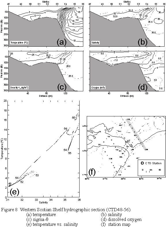
Conditions on Section V
(Fig.8) across the western Scotian Shelf are similar to those on Section IV,
except that the Gulf Stream/WCR water has not penetrated beyond the shelf
break, where a very sharp front exists.
Scotian Shelf waters from the east (S<31.5) are pervasive in the
surface layers over the shelf, with the major transition in properties
occurring at CTD54 (Fig.8e). The T-S
plot also indicates some mixing with a water mass other than that offshore at
CTD53, perhaps a remnant of the cold intermediate layer on the shelf or
Labrador Slope Water. Again the surface
oxygens differ between inshore and offshore waters.
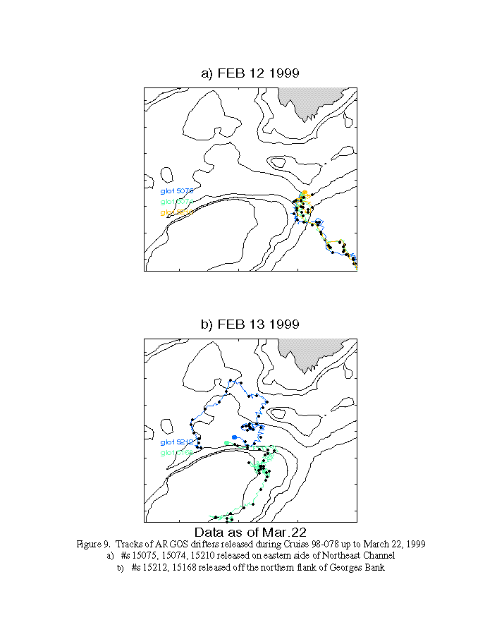
6. DRIFTER DEPLOYMENTS
A complement of five
WOCE-style drifters (spherical surface flotation ball encasing ARGOS
transmitter, holey sock drogue centred at 10 m) were deployed during the
mission (Table 5). After an eddy-like
feature in Northeast Channel was crudely mapped, three of the drifters were
placed in a line across the eastern front of the eddy (between CTD13-14; see
Table 2, Fig.1a) to determine whether the eddy flow field would sweep them
across the Channel.
The remaining pair of
drifters was deployed off the northern flank of the Bank (at CTD21,22; see
Table 2, Fig.1a) to determine whether there was direct flux across the Bank
from Georges Basin.
Drifter tracks (as of March
22, 1999; Fig.9) indicate that the three buoys deployed on the eastern side of
the Channel were indeed swept across to the west, then were drawn off into the
slope water by a Gulf Stream warm-core ring.(Fig.9a). Of the two buoys deployed off the northern flank, they converged
at first, then split, with the inner one passing onto Northeast Peak, and the
outer executing a circuit counter-clockwise around Georges Basin (Fig.9b).
7. FLOW-THROUGH SYSTEM
Surface fields based on the
flow-through system (Fig.10a,b) reveal cold, fresh water (T»2-3oC. S<31.5) over the Scotian
Shelf to its edge, beyond which lies a warm-core ring (T>17oC.
S>36.0) bounded by a sharp front near the 1000m isobath. Conditions over inshore Browns Bank and
across Georges Basin are somewhat warmer and saltier (T»3-4oC. S<32), while on Georges
Bank, conditions are warmer and saltier still (T»5-6oC.
S~32.5). Surface properties over
Northeast Channel and the eastern tip of Georges Bank are quite variable where
an intruding tongue of slope water meets the Scotian Shelf surface water near
the mooring line (Section Ia; Fig.3).
There is also some evidence for the presence of Scotian Shelf water over
the eastern and southeastern flanks of Georges Bank near the 100m isobath.
Surface nutrient fields
(Fig.10c-e) appear to have low concentrations for this time of year, based on
historical observations (B. Petrie, personal comm.). In particular, surface values of nitrate are expected to be in
the 8-12mM range over the western
Scotian Shelf in mid-February, compared to the observed values of 4-6mM (Fig.10c).
Similar levels are expected for the Gulf of Maine surface waters,
compared with the observed values of 7-8mM over Georges Bank.
Acknowledgements:
We are greatly indebted to the officers and crew of the C.C.G.S.
Parizeau for their skilled assistance and friendly cooperation, which was vital
to the success of this mission. We also
thank Erica Head, Jim Reid and Jeff Anning for their advice and support with
the biological sampling systems.
LIST OF TABLES
Table 2. CTD Stations During C.C.G.S. Parizeau 98-078, 10-16 February 1999
b)
Surface Dissolved Oxygen Regression Results for Parizeau 98-078
c)
5 dBar Corrected CTD vs. Flow-Through System for Parizeau 98-078
d) Extracted Chl-a vs. CTD
Fluorometer for Parizeau 98-078
Mooring Site N. Lat. Placement Instrument
No. (Depth,m) W. Long. Time(Z),Date (Depth,m)
Guard Buoy “V” NECW 42o07.38’ 1325, Feb.12 SC2325(1)
(213) 66o01.08’
_________________________________________________________________________________
TABLE 2. CTD Stations During C.C.G.S. Parizeau 98-078, 10-16 February
1999
|
|
|
|
|
|
|
|
|
Stn.
No. |
Latitude |
Longitude |
Sounding |
Yearday |
Date Time(UTC) |
Sampling |
|
|
|
|
(m) |
|
dd/mm/yy
hrs |
|
|
1 |
44
16.00 N |
63
18.99 W |
158 |
42 |
11/2/99
0235 |
|
|
2 |
42
24.85 N |
65
43.77 W |
102 |
|
11/2/99
2227 |
|
|
3 |
42
20.19 N |
65
47.85 W |
101 |
|
11/2/99
2328 |
|
|
4 |
42
16.27 N |
65
52.09 W |
223 |
43 |
12/2/99
0028 |
|
|
5 |
42
11.97 N |
65
56.41 W |
228 |
|
12/2/99
0129 |
|
|
6 |
42
07.56 N |
66
02.03 W |
210 |
|
12/2/99
0242 |
|
|
7 |
42
03.75 N |
66
04.67 W |
98 |
|
12/2/99
0333 |
|
|
8 |
41
59.25 N |
66
08.35 W |
96 |
|
12/2/99
0439 |
|
|
9 |
41
53.39 N |
65
59.89 W |
98 |
|
12/2/99
0539 |
|
|
10 |
41
57.38 N |
65
54.96 W |
113 |
|
12/2/99
0628 |
|
|
11 |
42
01.98 N |
65
51.00 W |
251 |
|
12/2/99
0723 |
|
|
12 |
42
06.06 N |
65
47.08 W |
250 |
|
12/2/99
0822 |
|
|
13 |
42
10.04 N |
65
42.58 W |
279 |
|
12/2/99
0915 |
Dr#15075 |
|
14 |
42
14.00 N |
65
38.47 W |
117 |
|
12/2/99
1022 |
Dr#15210 Bot/Bong |
|
15 |
42
01.98 N |
66
17.98 W |
82 |
|
12/2/99
1452 |
Bot/Bong |
|
16 |
42
08.94 N |
66
25.87 W |
161 |
|
12/2/99
1646 |
|
|
17 |
42
17.06 N |
66
31.90 W |
265 |
|
12/2/99
1806 |
|
|
18 |
42
25.99 N |
66
39.01 W |
328 |
|
12/2/99
1931 |
Bot/Ring |
|
19 |
42
34.10 N |
66
45.10 W |
232 |
|
12/2/99
2137 |
|
|
20 |
42
29.01 N |
66
55.99 W |
306 |
|
12/2/99
2257 |
|
|
21 |
42
21.03 N |
67
04.99 W |
319 |
44 |
13/2/99
0029 |
Dr#15212 |
|
22 |
42
14.96 N |
67
14.91 W |
242 |
|
13/2/99
0214 |
Dr#15168 |
|
23 |
42
06.03 N |
67
06.88 W |
55 |
|
13/2/99
0412 |
Bot/Bong |
|
24 |
41
56.98 N |
66
59.98 W |
56 |
|
13/2/99
0633 |
|
|
25 |
41
48.01 N |
66
53.03 W |
66 |
|
13/2/99
0816 |
|
|
26 |
41
40.05 N |
66
46.01 W |
69 |
|
13/2/99
1020 |
|
|
27 |
41
30.02 N |
66
39.00 W |
80 |
|
13/2/99
1221 |
|
|
28 |
41
23.04 N |
66
32.93 W |
93 |
|
13/2/99
1346 |
Bot/Bong |
|
29 |
41
17.82 N |
66
29.77 W |
92 |
|
13/2/99
1525 |
|
|
30 |
41
07.83 N |
66
22.10 W |
141 |
|
13/2/99
1703 |
|
|
31 |
40
59.92 N |
66
14.92 W |
990 |
|
13/2/99
1825 |
|
|
32 |
41
06.96 N |
66
05.95 W |
1463 |
|
13/2/99
1956 |
|
|
33 |
41
14.00 N |
65
53.99 W |
1960 |
|
13/2/99
2140 |
|
|
34 |
41
20.98 N |
65
46.02 W |
2200 |
|
13/2/99
2317 |
|
|
35 |
41
31.02 N |
65
54.17 W |
385 |
45 |
14/2/99
0100 |
Bot/Ring |
|
36 |
41
44.01 N |
66
03.94 W |
98 |
|
14/2/99
0410 |
Bot/Bong |
|
37 |
41
41.02 N |
65
15.93 W |
2245 |
|
14/2/99
0813 |
|
|
38 |
41
51.99 N |
65
25.98 W |
1740 |
|
14/2/99
1002 |
|
|
39 |
42
02.06 N |
65
33.06 W |
678 |
|
14/2/99
1142 |
Bot/Ring |
|
40 |
42
11.01 N |
65
36.95 W |
120 |
|
14/2/99
1422 |
Bot/Bong |
|
41 |
42
21.98 N |
65
46.94 W |
148 |
|
14/2/99
1647 |
Bot/Bong |
|
42 |
42
31.01 N |
65
55.98 W |
124 |
|
14/2/99
1850 |
|
|
43 |
42
39.99 N |
66
04.01 W |
72 |
|
14/2/99
2012 |
Bot/Bong |
|
44 |
42
47.04 N |
66
09.06 W |
58 |
|
14/2/99
2140 |
Bot/Bong |
|
45 |
42
56.06 N |
66
06.14 W |
129 |
|
14/2/99
2337 |
|
|
46 |
43
02.07 N |
66
06.04 W |
99 |
46 |
15/2/99
0034 |
|
|
47 |
43
09.00 N |
65
55.02 W |
90 |
|
15/2/99
0157 |
|
|
48 |
43
15.98 N |
65
47.00 W |
45 |
|
15/2/99
0309 |
|
|
49 |
43
03.98 N |
65
37.92 W |
92 |
|
15/2/99
0443 |
|
|
50 |
42
54.94 N |
65
29.93 W |
134 |
|
15/2/99
0557 |
Bot |
|
51 |
42
45.97 N |
65
23.03 W |
105 |
|
15/2/99
0730 |
|
|
52 |
42
38.00 N |
65
16.06 W |
98 |
|
15/2/99
0849 |
|
|
53 |
42
28.02 N |
65
09.06 W |
117 |
|
15/2/99
1018 |
|
|
54 |
42
20.05 N |
65
02.06 W |
293 |
|
15/2/99
1147 |
|
|
55 |
42
11.01 N |
64
55.03 W |
1602 |
|
15/2/99
1338 |
|
|
56 |
42
03.02 N |
64
46.96 W |
1773 |
|
15/2/99
1517 |
|
|
57 |
42
16.00 N |
63
19.10 W |
157 |
47 |
16/2/99
1023 |
Bot/Ring |
|
|
|
|
|
|
|
|
|
|
|
|
|
|
|
|
|
|
|
|
|
|
|
|
TABLE 3a. Salinity Calibration Results for Parizeau 98-078
QUANTITY NO. SAMPLES MEAN
DIFF. STD. DEV.
CTD vs. Standard
Salinity:
CTD-AutoSal. 13 -0.028 0.014
Flowthru-AutoSal 7 -0.173 0.040
______________________________________________________________________________
TABLE 3b. Surface Dissolved Oxygen Regression Results for Parizeau 98-078
Y
= aX+b (Y=saturation, X=sensor)
SENSOR(CTD) SAMPLES a±da b±db(ml/l)
±dY(ml/l)
r2
SBE 23-Y 56 0.835±0.026 0.812±0.197 ±0.156 0.950
TABLE 3c. 5 dBar Corrected CTD vs. Flow-Through System for Parizeau 98-078
Y = aX+b (Y = 5 dBar CTD, X = flow-thru system)
VARIABLE SAMPLES a±da b±db ±dY r2
Temperature (oC) 51 1.016±0.004 -0.505±0.032 ±0.127 0.999
Salinity (psu) 51
-0.154±0.011
_____________________________________________________________________________
TABLE 3d. Extracted Chl-a vs. CTD Fluorometer for Parizeau 98-078
Y
= aX+b (Y=Extracted Chl-a, X=sensor
output)
SENSOR (CTD) SAMPLES a±da
b±db(mg/l) ±dY(mg/l) r2
SeaTech 72 1.68±0.16 0.05±0.09 ±0.41 0.63
TABLE 4a. Click here.
TABLE 4b. Click here.
TABLE 5. Drifter Deployments
during C.C.G.S. Parizeau 98-078
Buoy ID# N. Lat. W. Long. Time(Z),Date
15075 42o10.04’ 65o42.58’ 0930, 12 Feb.
15074 42o12.02’ 65o40.69’ 0954, 12 Feb.
15210 42o14.00’ 65o38.47 ‘ 1022, 12
Feb.
15212 42o21.05’ 67 05.01’ 0050,
13 Feb.
15168 42o15.07’ 67o14.80’ 0233, 13 Feb.
FIGURE CAPTIONS:
Figure 1 a)
Mooring sites, and CTD positions for C.S.S. Parizeau
Cruise 98-078, 10-16 February 1999
b)
Guard buoy mooring diagram.
Figure 2 Calibration data for: a) near-surface saturation O2 vs.
YSI measured O2, b) CTD 5 dbar T vs. measurements from the
flow-through system and c) CTD 5 dbar S vs. measurements from the flow-through
system. Regression lines are defined in Tables 2b and 2c.
Figure 3 Hydrographic section Ia (CTD2-8)
across Northeast Channel at the mooring line.
(a)
temperature,
(b)
salinity,
(c)
sigma-q,
(d)
dissolved oxygen
(e)
temperature vs. salinity, and
(f)
station map
Figure 4 Hydrographic section Ib (CTD9-14)
across Northeast Channel 10 km seaward of the mooring line.
(a)
temperature,
(b)
salinity,
(c)
sigma-q,
(d)
dissolved oxygen,
(e)
temperature vs. salinity, and
(f)
station map
Figure 5 Hydrographic
section II (CTD22-31) across eastern Georges Bank proper.
(a)
temperature,
(b)
salinity,
(c)
sigma-q,
(d)
dissolved oxygen,
(e)
temperature vs. salinity, and
(f)
station map
Figure 6 Hydrographic section III
(CTD8,9,15-19,34-36) across the eastern tip of Georges Bank from the slope
water to Georges Basin.
(a)
temperature,
(b)
salinity,
(c)
sigma-q,
(d)
dissolved oxygen,
(e)
temperature vs. salinity, and
(f)
station map
Figure 7 Hydrographic
section IV (CTD37-48) from Cape Sable along the western flank of Browns Bank to
the slope water inflow
(a)
temperature,
(b)
salinity,
(c)
sigma-q,
(d)
dissolved oxygen (replace with CTD23,28-29,21),
(e)
temperature vs. salinity, and
(f)
station map
Figure 8 Hydrographic section V (CTD48-56)
across the western Scotian Shelf to the slope water.
(a)
temperature,
(b)
salinity,
(c)
sigma-q,
(d)
dissolved oxygen,
(e)
temperature vs. salinity, and
(f)
station map
Figure 9 Tracks of ARGOS drifters released
during Voyage 98-078 up to March 22, 1999.
a)
#s15075,
15074, 15210 on eastern side of Northeast Channel
b)
#s
15212, 15168 off the northern flank of Georges Bank
Figure 10 Near-surface fields from the flow
through system data posted approximately every 30 minutes.
a)
Temperature
b)
Salinity
c)
Nitrate
d)
Phosphate
e)
Silicate
Figure 1 a Mooring sites, and CTD positions for C.S.S. Parizeau Voyage
98-078, 10-16 February 1999
 |
10-16 February 1999

Figure 2a. Calibration data for 5 dbar saturation O2 vs. YSI measured O2. Regression line is defined in Table 3b.
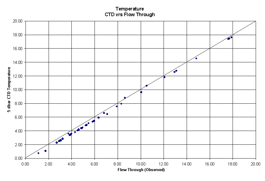
Figure 2b. Calibration data for CTD 5 dbar T vs. measurements from the
flow-through system. Regression line is
defined in Table 3c.
Figure 2c. Calibration data for CTD 5 dbar S vs. measurements from the flow-through system. Regression line is defined in Table 3c.

To see a gif version of the figure referenced below (Figure 9), click here.

Figure 9. Tracks of ARGOS drifters released during
Cruise 98-078 up to March 22, 1999
a)
#s
15075, 15074, 15210 released on eastern side of Northeast Channel
b) #s 15212, 15168 released off the northern flank of Georges Bank
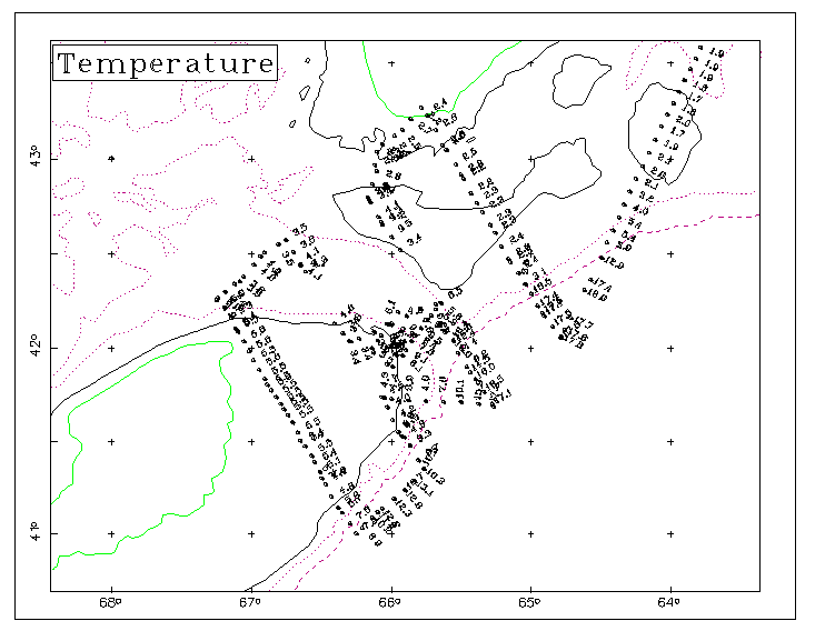
Figure 10a Flow through system temperature posted approximately every 30
minutes.
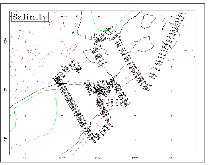
Figure 10b
Flow through system salinity posted approximately every 30 minutes.

Figure 10c
Flow through system nitrate posted approximately every 30 minutes.
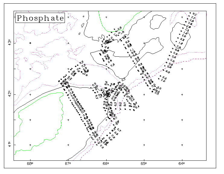
Figure 10d Flow
through system phosphate posted approximately every 30 minutes.
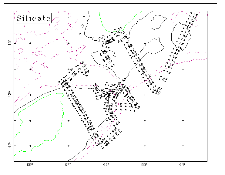
Figure 10e Flow through system silicate posted approximately every 30 minutes.