REPORT ON C.S.S. Parizeau
CRUISE 99-028
23 - 30 September, 1999
by
Peter C. Smith, Rick Boyce
and Liam Petrie
Ocean Sciences Division
Bedford Institute of
Oceanography
Dartmouth, Nova Scotia
CANADA
October, 1999
BEDFORD INSTITUTE OF OCEANOGRAPHY CRUISE REPORT Parizeau 99-028
Local Cruise Designation: 99-028
Vessel: C.S.S.
Parizeau
Dates: 23-30
September, 1999
Area: Southwest
Nova Scotia/Georges Bank
Responsible Agency: Ocean
Sciences Division
Maritimes
Region, DFO
Ship's Master: Capt.
J. Dockrill
Scientific Personnel:
R. Boyce Ocean
Sciences
M. Scotney Ocean
Sciences
L. Petrie Ocean
Sciences
B. Nickerson Ocean
Sciences
D. Kellow Ocean
Sciences
M. Holtom MEDS
1. PURPOSE
The scientific objectives of this cruise were:
1.
Time-series
measurements of currents, temperature, and salinity at key locations for the
cross-over flow from Browns to Georges Bank in the surface layers,
2.
Distribution
of temperature, salinity, dissolved oxygen and nutrients in the vicinity of
SWNS and eastern Georges Bank,
3.
Lagrangian
measures of surface drift on Browns and eastern Georges Banks.
The activities planned for
the cruise period included:
1.
Recover
eight moorings at four sites (NECE,NECW,BBO,BBI) on Browns Bank and in
Northeast Channel (Figure 1a),
2.
Conduct
CTD/ADCP survey of SWNS and eastern Georges Bank,
3.
Conduct
a CTD/ADCP section of the local Gulf Stream/WCR front,
4.
Run
CTD section on Halifax line
2. NATURE OF DATA GATHERED
Eight moorings were
successfully recovered at four different sites (Table 1, Fig.1a).
The top two instruments on mooring 1291A had been previously parted from
the mooring and the RCM was returned to BIO, but the Microcat was lost. All instruments (18 RCMs, 1 Microcat) appear
to have worked, except for moderate amounts of growth and one missing rotor
(Table 1)
A total of 67 CTD stations
(Fig.1b, Table 2) were occupied at the mooring sites and along the following
sections:
1) Section Ia - from the 50 m
isobath off Cape Sable to the outer edge of Browns Bank (Fig.3),
2) Section Ib - across Northeast
Channel from Browns to Georges Bank on
the mooring line, i.e. near the sill (Fig.4),
3)
Section
II - across the mouth of Northeast Channel (Fig.5),
4)
Section
III - across the western flank of Browns Bank (Fig.6)
5)
Section
IV - along the 130-200 m isobath on the eastern side of the Channel, from
Georges Basin to the mouth (Fig.7),
6)
Section
V across the Gulf Stream/WCR front on 65o 30’W (Fig.8),
7)
Section
VI across the shelf break off Baccaro Bank (Fig.9), and
8) the
Halifax Section (Fig.10).
The quality of the CTD
salinity measurements is quite acceptable (Table 2a), especially considering
the relatively high variability of the standards used. The YSI dissolved oxygen sensor showed an
offset with respect to the Orion probe samples (Table 2a), but stable calibrations
were obtained by linear regression of sensor vs. the Orion probe and titrated
values (Table 2b, Fig.2a,b). The YSI
sensor exhibited occasional noise, spikes, and hysteresis between the up- and
downtraces. In addition, roughly 100
oxygen isotope samples were collected throughout the water column at even
numbered stations (Fig.1b) for Dr. Robert Houghton of Lamont-Doherty Earth
Observatory. Nutrient samples were
collected throughout the water column as well at the even-numbered stations.
3. PROGRAM SUMMARY
Date From(UTC) To(UTC) Operation
23 Sept 1000 1200 Basin trials for CTD, Lifeboat drill
1200 0230(24) Steam to first CTD site
24 Sept 0234 1755 CTD1–17
1850 2330 Recovery of mooring’s 1294 & 1295
25 Sept 0048 1140 CTD18–24
1214 1445 Recovery of mooring’s 1291 & 1291A
1632 1641 CTD 25
1658 2117 Recovery of mooring’s 1290 & 1290A
2158 2200 Deployed drifter #3012
26 Sept 0024 1141 CTD26–35
1240 1610 Recovery of moorings 1292 & 1293
1800 0100(27) Searching for drifter
27 Sept 0129 1733(29) CTD36–67
29 Sept 2000 Arrive BIO
4. MOORING OPERATIONS
Recovery
of 8 current meter moorings and 12 guard buoys at 4 sites (Table 1) proceeded
without incident. The Fairey float and
current meter (RCM7122)) at BBO mooring 1291A had been previously recovered and
returned by a fisher, however the Microcat 0373 was not returned. The rest of
the mooring was recovered successfully however it was off position by 2.3
cables to the northwest. Just two guard buoys went adrift during the mooring
period with the Coast Guard replacing one.
This is not a bad record, considering they had been in the water for
roughly 10 months and had survived both winter storms and Hurricane Floyd. Some difficulty was encountered with
snarling of the chain at the base of the guard buoy mooring lines, causing it
to come up in large lumps. A guard buoy
at NECW was instrumented with a Microcat and and Argos transmitter. This system
failed during part of the mooring period and was repaired and replaced in
Jan/99.
The
moorings had moderate growth toward the top with less growth towards the anchor
end. Only two conductivity sensors and rotors were fouled. One current meter
was recovered with the rotor missing but this may have happened during
recovery. The rest of the moorings and
instruments were recovered in good shape and appeared to have worked during the
mooring period.
Problems/Recommendations:
(1) A
solution is needed to prevent the chain at the base of the guard buoy moorings
from snarling.
5. HYDROGRAPHIC MEASUREMENTS
Hydrographic and chemical measurements were made at a total of 67 stations (Table 2) using a Seabird 9/11 Plus system (the “WOCE system”), equipped with a SBE 23Y Yellow Springs Instruments (YSI) dissolved oxygen sensor. The data were logged on a 33 Mhz 486 PC and post-processed between stations using SEABIRD's software. Once processed, the data were backed up to a CD-ROM.
Water column sampling was
accomplished with a SeaBird Carousel 12-bottle rosette. Duplicate nutrient and single oxygen isotope
samples were drawn at roughly standard depths on alternate stations only. Duplicate dissolved oxygen samples were
drawn at 50m. In addition, two
calibration bottles were tripped at the bottom of each cast for roughly
replicate nutrients, salinities and dissolved oxygens. Due to limited numbers of sample bottles,
nutrient and oxygen isotope sampling were curtailed after stations 43(save 66)
and 23, respectively (see Table 2).
The SeaBird system worked
well throughout the cruise. However,
sampling was a problem in that there was often not enough water in the 1.7L
bottles to fill all of the required sample bottles. Part of this problem was due to the use of 300 ml bottles for the
O2 samples. The accuracy of
the salinity samples seemed to suffer most, and the suggestion was made to draw
the salinity sample first because of its importance in sorting out bottle
misfires and leaking.
5a. Processing
The processing of CTD data
was initiated by a single command on the PC at the end of the station. This command, called PROCESS, starts a batch
job that sequentially passes the data through a number of programs. Most were
from SEABIRD's SEASOFT package. A few
were custom written at BIO. The
following is a summary of the processing procedure [modifications required for
the manual bottle trip procedure are indicated in square brackets]:
(0) [Run MARKSCAN to create .BSR
(bottle scan records) file from .MRK file, created by hitting (cntrl-f5) after
a bottle is tripped.]
(1) Convert
raw frequency data to binary pressure, temperature and conductivity using
SEABIRD's DATCNV program. [.ROS file is
based on either bottle flags within the data stream (normal), or on information
from the .BSR file (manual procedure)]
(2) Split the file into the up and
down traces using SEABIRD's SPLIT program.
(3) Check downcast for and mark any
'wild' data points with SEABIRD's WILDEDIT program.
(4) Filter downcast conductivity and
temperature using SEABIRD's FILTER program. This is a low pass filter and we
used a time constant of 0.045 seconds for conductivity and 0.15 seconds for
temperature.
(5) Mark downcast scans where the CTD
is moving less than the minimum velocity of 0.10 m/s using SEABIRD's LOOPEDIT
program.
(6) Align downcast pressure,
temperature and conductivity using SEABIRD's ALIGNCTD program by advancing the
conductivity signal by 0.01 sec.
(7) Apply the thermal mass correction
for the conductivity cell using SEABIRD's CELLTM program.
(8) Compute dissolved oxygen in ml/l
using SEABIRD's DERIVE program.
(9) Create WOCE 2-dbar dataset using OSD program PRO-WOCE.
(10) Bin average downcast data to
1.0-dbar intervals using SEABIRD's BINAVG program.
(11) Compute downcast salinity,
potential density(sq), potential temperature(q), and depth using SEABIRD's DERIVE program.
(12) Convert the down cast from binary
to ASCII using SEABIRD's TRANS program.
(13) Convert downcast to ODF format
using PCS program SEAODF.
(14) Create IGOSS message using PCS
program ODF_IGOS.
(15) Prepare batch and command files to
transfer the data to the VAX and create the input for SEABIRD's ROSSUM program
using our customized MAKEFILE program.
(16) Check for bottles, then use ROSSUM
to create the rosette summary file.
(17) Convert the resulting .BTL file to
a format suitable for ingestion into Quattro PRO (.QAT file) using our
customized QPROBTL program.
(18) Create the calibration file of
merged up- and down-cast data using OSD program CALIB.
(19) Copy Quattro, downcast, and ODF
files to appropriate directories and clean up.
Plots and status info
displayed by the SEASAVE program during the acquisition are discarded when the
program terminates. The post-processing
plotting was not included in the batch job because SEABIRD's SEAPLOT program
requires interactive operator attention.
Plots produced after each station include T, S, O2, and sq vs. pressure and T vs. S.
Attempts to produce section plots with Igor Yakashev’s contour package,
modified to accept .ODF files, were frustrated by improper header information
in the ODF files. “Station” and “Cast”
numbers were confused, causing problems to propagate into the processed
files. The only foolproof solution
appears to be reprocessing of the entire data set, which is presently underway.
5b. Calibration
At the base of each CTD cast
two rosette bottles were tripped and a single salinity sample was drawn from
each to be analyzed onboard with an Guildline AutoSal salinometer. Assuming that the temperature offset for the
WOCE system is negligible, the comparison of the salinity standards against the
SeaBird CTD (Table 2a below) shows that the mean offset is small and not
significantly different from zero.
However, the standard deviation about this mean is unacceptably large
(order of magnitude higher), even after accounting for outliers based primarily
on replicate sampling. Some of this
variability may be due to real time dependence in the properties at the base of
each cast, but part may be due to sampling techniques which need to be
re-examined.
The performance of the YSI O2
sensor was similar to that on previous cruises. The surface values on the downtrace appeared to be fully
equilibrated, thanks to a 3 min. waiting period (as suggested by the
manufacturer), but there was usually a large hysteresis between the down- and uptraces
in the vicinity of the pycnocline, and there were occasional spikes from the
electronics. The hysteresis probably
results from a mismatch of the temperature and O2 sensors in the
probe and might be improved by applying filters with appropriate phase lags.
The dissolved oxygen samples collected from 300-ml calibration bottles were
analyzed on board with an Orion 853 oxygen probe, borrowed from Marine
Chemistry. The mean offset of the YSI
over the entire cruise was significantly different from zero (Table 2a) and the
standard deviation about the mean was substantial (0.3 ml/l). A linear regression (Table 2b) of the Orion
standard on the YSI values from the CTD provides a calibration for the YSI with
a standard error of ±0.3 ml/l (Figure 2a). To assess the quality of the Orion standard,
“replicate” O2 samples were obtained from the 50-m rosette bottle,
and “near-replicate” samples were drawn from the two bottles at the base of the
cast. Overall, these “replicates”
agreed to within a mean difference of 0.02 ml/l, but with a standard deviation
of 0.11 ml/l (or better discounting outliers; Table 2a). As a further check on the Orion sensor,
standard Winkler analysis was performed on 8 samples drawn from a late CTD cast
(CTD65) and “pickeled” before their return to BIO 12 hours later. Although the Winkler replicates showed
substantial variation (Table 2a), their average was quite consistent with the
Orion results (Table 2b: Figure 2b)
Problems/Recommendations:
(1)
Efforts should be made to
remove the hysteresis between the up and down traces from the YSI sensor by
application of filters with various lags.
(2)
Salinity samples should be
drawn first from small (1.7L) rossette bottles.
(3)
Smaller O2 sample
bottles should be used
(4)
The new CTD computers
require WINZIP and OFFICE 97 software.
5c. Sections
CTD sections Ia,b, II, III,
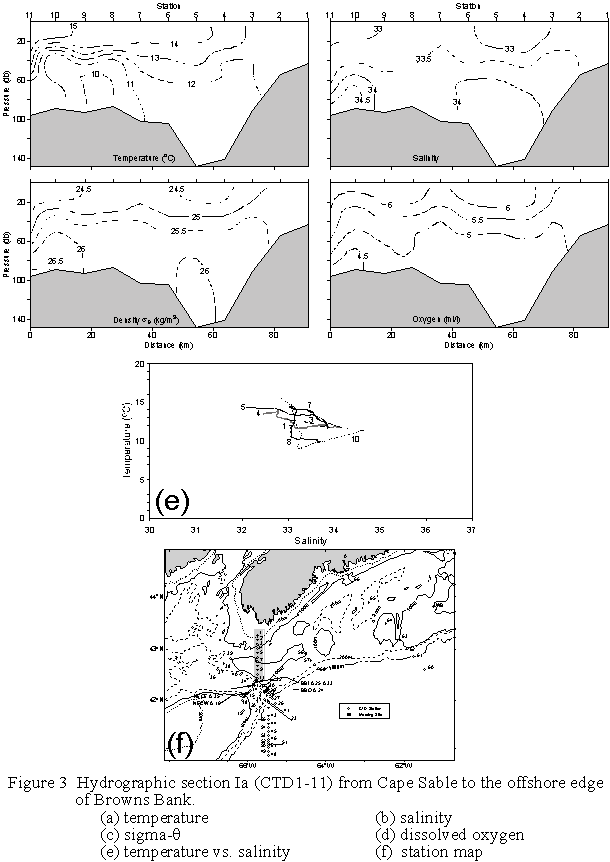
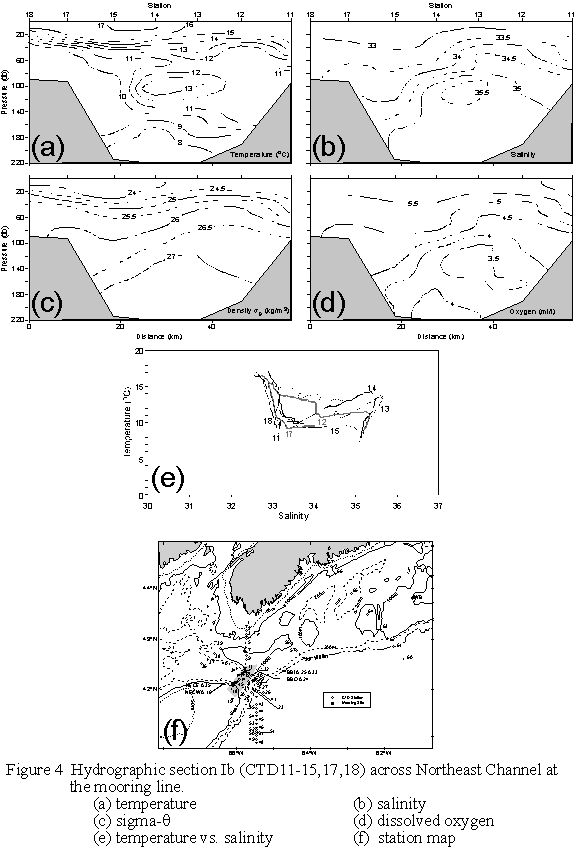
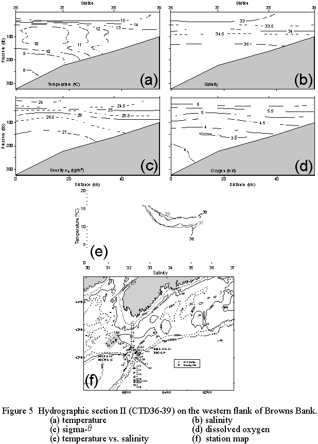
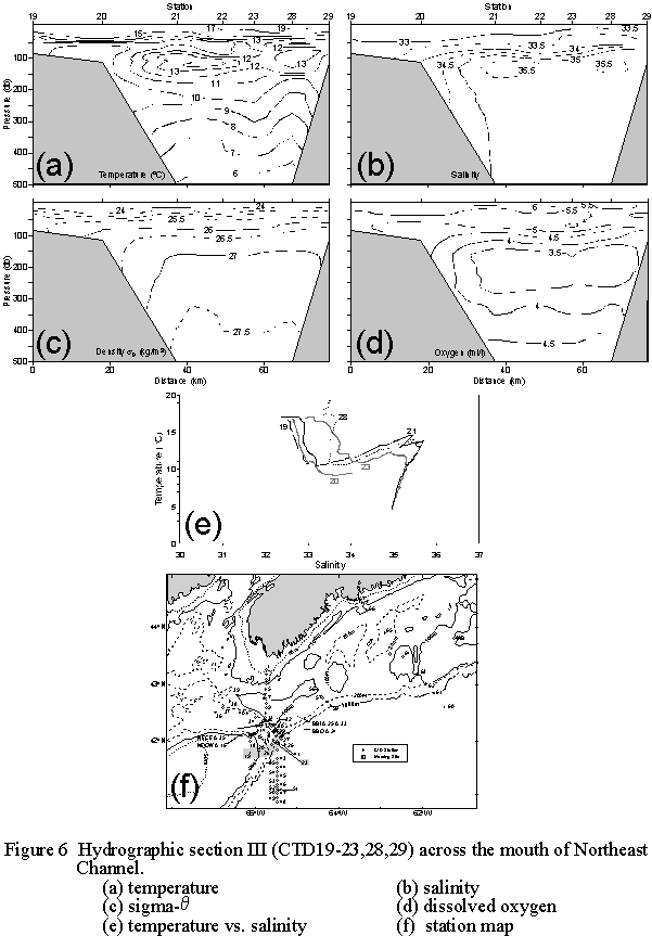
IV, V, VI and VII (Figs. 3-10) depict hydrographic conditions, respectively, 1)
along the eastern boundary of the Gulf of Maine, 2) across the sill in
Northeast Channel, 3) down the western flank of Browns Bank, 4) from Georges Bank
across the mouth of Northeast Channel, 5) along the 200 m isobath on the
eastern side of the Channel, 6) across the front of a Gulf Stream warm-core
ring, 7) across the shelf break off Baccaro Bank, and 10) along the Halifax
Section, spanning the entire Scotian Shelf off Halifax. Section Ia (Fig.3) shows two surface layer
pockets of fresh water lying between Cape Sable and Browns Bank and over the
outer edge of Browns. Conditions in these two zones are stratified by both
temperature and salinity, while the inshore region off Cape Sable and the cap
of Browns are vertically well mixed. A
weak cold intermediate layer is evident over the outer Bank (CTD10), and a
similar hint appears at CTD4.
Section Ib (Fig.4) shows the
presence of Warm Slope Water or Gulf Stream water, centered at 100m, in the
region of strong inflow currents near the NECE mooring (CTD13). A strong oxygen minimum (O2<3.5
ml/l) at 120-160m is associated with this warm salty tongue on the eastern side
of the Channel. The warm, fresh
(T>15 oC; S<33.5) surface layer thickens markedly over the
western side of the Channel.
Upward-sloping isopycnals to the east suggests deep inflow and surface
outflow.
Section II (Fig.5) again
reveals a hint of the cold intermediate layer in Georges Basin (e.g. CTD37),
with minimum temperatures at 100m dropping below 10oC. There is also a vestige of the O2
minimum at ~150m, and salinities below that depth uniformly exceed 35. The surface layer is again warm and fresh
and there is some evidence of vertical mixing on the upper part of the slope,
where the isopycnals tend to splay.
Section III (Fig.6) also
shows the warm, saline water extending almost entirely across the mouth of
Northeast Channel, with maximum salinities >35.5 and temperatures >14oC
at depths of 100-150m isobath.. The
surface layer on the eastern side of the Channel is both fresher and warmer
than on the western side, where the density stratification is also weaker. The
core of a thick oxygen minimum layer lies roughly between 150 and 250 m.
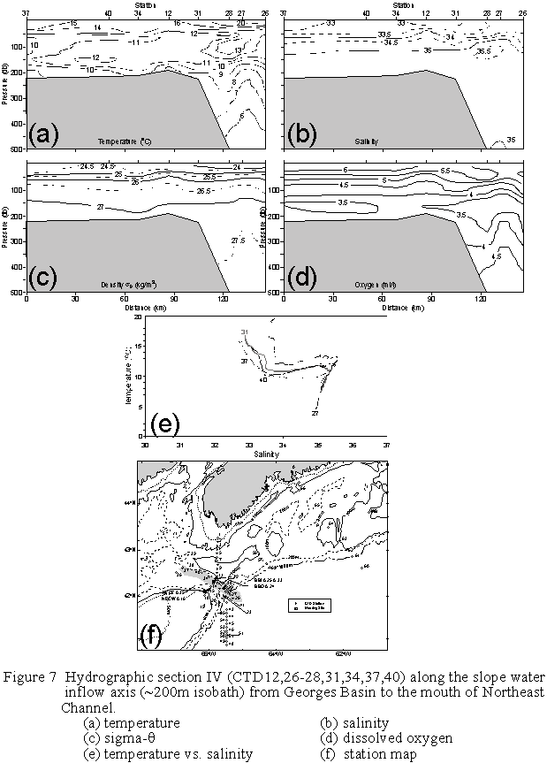
Conditions on Section IV
(Fig.7), from the mouth of Northeast Channel to Georges Basin along the eastern
200m isobath show the gradual erosion and mixing of the incoming layer of Warm
Slope/Gulf Stream Water. The S=35
isohaline sinks along the Channel from <100m to around 130m, and the
temperatures do not exceed 13oC in the Channel itself. The surface layer is also cooler and fresher
inside the Channel. The oxygen minimum
layer extends into the Channel at depths of 150-200m.
Section V (Fig.8) depicts
the sharp transition in properties at a Gulf Stream/Warm Core Ring front which
lay off the mouth of Northeast Channel near 41o 10’N on 65o
30’W. Surface layer temperatures and
salinities south of the front were in excess of 20oC and 36,
respectively, with a salinity contrast of 3.0 across the front itself. Beneath the Gulf Stream water, isopycnals
slope sharply upward to the north, indicating the strong vertical shear in the
eastward flow. Similarly, on the
coastal side of the front, the near surface isopycnals slope weakly upward to
the north. The core of the oxygen
minimum layer rises up from deep under the Gulf Stream water to lie between
200-250m to the north.
The offshore end of Section
VI (Fig.9) also appears to pass through a bolus of Warm Slope Water at depths
of 50-200m, with salinities in excess of 35.5 and temperatures of 13-18oC. Over the shelf, the surface layers are well
stratified by both temperature and salinity, but the deep water properties on
the shelf show little influence of the offshore waters. The cold intermediate layer is most
pronounced at CTD57 near the shelf break.
The Halifax Section data
(Fig.10) also reveal the presence of Gulf Stream water lying just off the shelf
at depths of 50-200m. A subsurface
front near the shelf break separates the war, saline water from the cooler,
fresher waters of the shelf. Over
Emerald Basin, a very fresh surface layer extends from the coast to Emerald
Bank, a cold intermediate layer is pressed against the coast at depths of
50-100m, and relatively warm (T=8-10oC), saline (S>35) slope
water resides in the deepest parts of the section.
Acknowledgements:
We are greatly indebted to the officers and crew of the C.S.S. Hudson
for their skilled assistance and friendly cooperation, which was vital to the
success of this mission.
TABLE 1. Moorings Recovered During Parizeau 99-028, 23-30 September 1999
Mooring Site N. Lat. Placement Instrument Comments
No. (Depth,m) W. Long. Time(Z),Date (Depth,m)
1290 BBI 42o20.53’ 2035, Sept.25 RCM7592(30) Growth
in cond. cell
(120) 65o44.13’ RCM4355(50)
RCM5574(100)
1290A BBIA 42o20.77’ 1838, Sept.25 RCM7525(16)
(122) 65o43.95’
1291 BBO 42o09.75’ 1420, Sept.25 RCM6403(30) Growth
on rotor
(120) 65o34.31’ RCM3196(50)
RCM4195(100)
1291A BBOA 42o09.99’ 1350, Sept.25 RCM7122(14) Previously
recovered
(118) 65o34.31’ by
a fisher in July/99
Microcat
0373(13) Missing
1292 NECEA 42o17.75’ 1405, Sept.26 Microcat 0286(23)
Growth on cell
(216) 65o50.41’ RCM7013(24) Growth on rotor and
cell
1293 NECE 42o17.69’ 1530, Sept.26 RCM4342(35)
(215) 65o50.66’ RCM9355(55)
RCM4602(105)
RCM5577(155)
1294 NECWA 42o07.79’ 2125, Sept. 24 RCM5359(23)
(216) 66o00.91’
1295 NECW 42o07.61’ 2210, Sept. 24 RCM7131(33)
(213) 66o00.84’ RCM9607(53)
RCM2664(103) Rotor missing
RCM6411(153)
TABLE 2. CTD Stations During Parizeau 99-028, 23-30 September, 1999

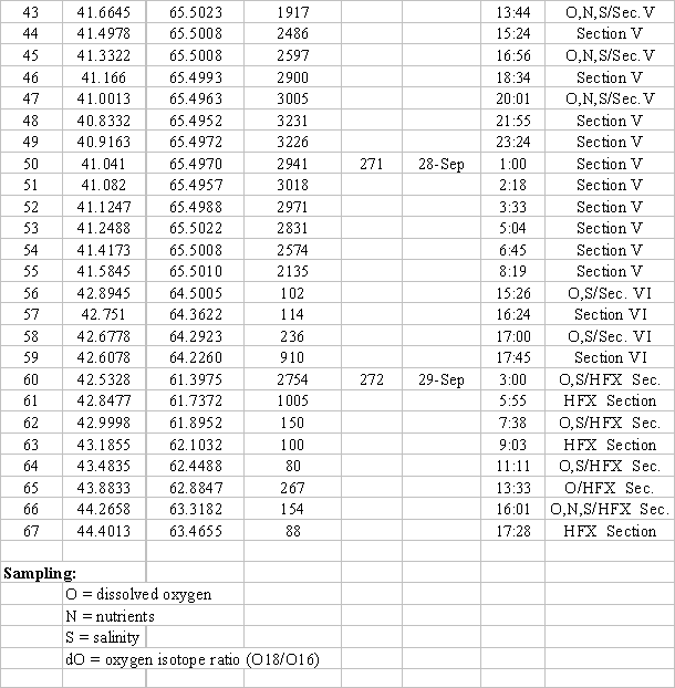
TABLE 2a. Temperature and Salinity Calibration Results for Parizeau 99-028
QUANTITY NO. SAMPLES MEAN
DIFF. STD. DEV.
±STD. ERR.
CTD vs. Standard
Salinity:
CTD-AutoSal. (0-66) 62 0.0039±0.0042 0.0329
“ (no outliers) 53 0.0012±0.0020 0.0145
Dissolved Oxygen:
YSI-Orion(0-66) 273 -0.081±0.018 0.299
Standard vs. Standard
Salinity:
Btl.1-Btl.2 (0-66) 29 -0.0060 0.0404
“ (no outliers) 20 -0.0009 0.0037
Dissolved Oxygen:
Btl.1-Btl.2 (0-66) 48 0.018 0.109
“ (no outliers) 37 0.013 0.060
Winkler1-Winkler2(same
btl.;65) 8 0.076 0.060
______________________________________________________________________________
TABLE 2b. Dissolved Oxygen Regression Results for Parizeau 99-028
Y
= aX+b (Y=Orion Standard, X=sensor)
SENSOR(CTD) NO. SAMPLES a±da b±db(ml/l) ±dY(ml/l) r2
YSI(0-67) 273 0.976±0.020 0.194±0.098 ±0.299 .894
Winkler (65) 8 1.036±0.014 -0.064±0.058 ±0.045 .999
______________________________________________________________________________
FIGURE CAPTIONS:
Figure 1 a)
Mooring sites, and b) CTD and biological stations for C.S.S. Parizeau
Cruise
99-028, 23-30 September 1999
Figure 2 a) Linear calibration curve for YSI
O2 sensor, based on Orion 853 standard (see Tables 2a,b); and b)
intercalibration of Orion and Winkler O2 standards.
Figure 3 Hydrographic
section Ia (CTD1-11) from Cape Sable to the offshore edge of
Browns
Bank.
(a)
temperature,
(b)
salinity,
(c)
sigma-q,
(d)
dissolved oxygen
(e)
temperature vs. salinity, and
(f)
station map
Figure 4 Hydrographic section Ib (CTD11-15,
17-18) across Northeast Channel at the mooring line.
(a)
temperature,
(b)
salinity,
(c)
sigma-q,
(d)
dissolved oxygen,
(e)
temperature vs. salinity, and
(f)
station map
Figure 5 Hydrographic
section II (CTD36-39) on the western flank of Browns Bank.
(a)
temperature,
(b)
salinity,
(c)
sigma-q,
(d)
dissolved oxygen,
(e)
temperature vs. salinity, and
(f)
station map
Figure 6 Hydrographic section III (CTD19-23,
28-29) across the mouth of Northeast Channel
(a)
temperature,
(b)
salinity,
(c)
sigma-q,
(d)
dissolved oxygen,
(e)
temperature vs. salinity, and
(f)
station map
Figure 7 Hydrographic section IV
(CTD12,26-28,31,34,37,40) along the slope water inflow axis (~200m isobath) from Georges Basin to the mouth
of Northeast Channel.
(a)
temperature,
(b)
salinity,
(c)
sigma-q,
(d)
dissolved oxygen,
(e)
temperature vs. salinity, and
(f)
station map
Figure 8 Hydrographic section V (CTD41-55)
across a warm-core ring/Gulf Stream front on 65o 30’W off Northeast
Channel
(a)
temperature,
(b)
salinity,
(c)
sigma-q,
(d)
dissolved oxygen,
(e)
temperature vs. salinity, and
(f)
station map
Figure 9 Hydrographic section VI (CTD56-59)
across the shelf break off Baccaro Bank.
(a)
temperature,
(b)
salinity,
(c)
sigma-q,
(d)
dissolved oxygen,
(e)
temperature vs. salinity, and
(f)
station map
Figure 10 Halifax hydrographic section (CTD60-67) from the Scotian Slope Water to
Halifax.
(a)
temperature,
(b)
salinity,
(c)
sigma-q,
(d)
dissolved oxygen,
(e)
temperature vs. salinity, and
(f)
station map
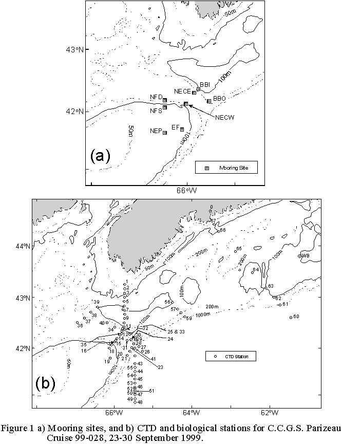
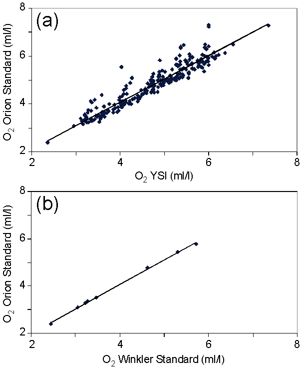
Figure 2 a) Linear calibration curve for YSI
O2 sensor, based on Orion 853 standard (see Tables 2a,b); and b)
intercalibration of Orion and Winkler O2 standards.