Craig M. Lee and Kenneth H. Brink Two cruises, one in March and the second in June-July 1997, investigated mechanisms which remove shelf water and biota off the southern flank of Georges Bank. A towed, undulating profiler (SeaSoar) made highly-resolved, quasi-synoptic, three dimensional surveys between approximately the 60 m and 2000 m isobaths. The SeaSoar measured temperature, conductivity, chlorophyll fluorescence, light transmission, PAR and both acoustic and video estimates of zooplankton abundance, while shipboard instruments measured currents and meteorological variables.
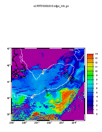
The wintertime (March) cruise took place during a period of intense storm activity. Satellite imagery (Figure 1) revealed an intrusion of cold, fresh water originating on the Scotian Shelf, crossing the unstratified waters of the Northeast Channel and extending southwestward along the southern flank of Georges Bank. In an effort to examine storm-induced cross-shelf transport, the region surrounding the shelf break front, including the intrusion, was intensively sampled before and after the passage of a strong storm system. Prior to the storm, the Scotian Shelf Water intrusion extended several kilometers inshore of the shelfbreak front, near the 100 m isobath, and was approximately 50 km wide. Intrusion waters were initially colder than 2 degrees C, fresher than 31.5 psu and typically confined in the vertical to the upper 50 m. Thus, the intrusion rode above both slope and shelf waters, forming a cap over the shelfbreak front. Observations following the storm found the intrusion had shifted slightly offshore of the shelfbreak front. Intrusion waters warmed and became more saline, presumably the result of vigorous mechanical mixing with the underlying slope waters during the storm.
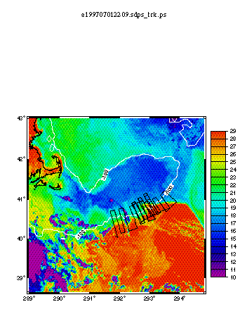
The summertime (June-July) cruise sampled interactions between the Bank and a plume of warm, Gulf Stream water which intruded onto the shelf (Figure 2). Our initial survey began near Ron Schlitz's moored array and worked eastward in a series of three 'radiator' sampling grids. Grid locations were chosen to sample: 1) the leading edge of interaction between Gulf Stream and the shelf waters, perhaps including the zone of flow reversal on the bank, 2) the region of maximum shear between Gulf Stream water in the feature and the mean flow on the Bank and 3) the region where the flow associated with the warm feature separates from the shelf, where imagery typically reveals streamers of cold water extending off-bank. Flow patterns and satellite imagery obtained during these initial surveys indicated that the feature was more plume-like (rather than ring-like) in character, with westward flows in the western region and eastward flows further east. Based on the results of the initial survey and motivated by our interest in shelf water removal, we chose to use the remainder of our time to execute repeated radiator surveys spanning the maximum shear region and the separation zone to the east of the feature. Four repeats of the survey pattern allowed us to document both spatial variability and the temporal evolution of the warm-water intrusion onto the Bank. During this period, the primary warm plume spawned a tendril which extended on-bank to the 60 m isobath. Fortunately, this feature was captured in our repeat sampling pattern.