Charles N. Flagg, Maureen Dunn, and Yan Shi
To date, approximately 40 GLOBEC cruises have taken place in the Georges Bank region on ships equipped with narrow-band ADCPs, yielding a total of about 360 days of data spanning the period from September 1994 through May 1998. We have used this data set to develop a tidal prediction scheme using Candela's method (Candela, Beardsley and Limeburner, 1992) covering the Bank, the Great South Channel and a portion of the Northeast Channel. Candela's method of fitting polynomials to the tidal coefficients is inadequate to be applied to the Bank as a whole so we have divided the Bank into four sub-regions and determined the fits for each region. Using these results we can predict the vertically averaged tidal currents anywhere on the Bank within approximately the 200 meter isobath and between Nantucket Shoals and Browns Bank based upon the five primary tidal constituents: M2, S2, N2, K1 and O1. The Matlab algorithm, coefficients, and instructions can be obtained from our ADCP web site ( www.oasdpo.bnl.gov/mosaic/globec).
The tables and figures below show the results of the tidal fitting effort and compare the derived coefficients with those published in the Moody tidal atlas. Also shown are the record mean currents for various sub-regions based upon the detided ADCP data. For the main part of the Bank, Great South Channel and the central portion of the Northeast Channel, the estimates of the tidal constituents are very good. The model does less well over the eastern tip of the Northeast Peak because of the sharp gradients in that area. While this method does reduce the tidal influences substantially, it is not capable of completely eliminatiing the barotropic tides from the currents because of subtle variations in the phases of the constituents which, in turn, may be the result of time variable bottom friction or perhaps larger scale currents effecting the propogation of the tidal waves. Internal tides can also be significant on the Bank but they are not phase-locked with the surface tides and thus are not amenable to a simpe filtering scheme applicable over a large number of cruises. Despite the method's limitations, it is useful because of its simplicity, ease of use, and its ability to be used in near realtime data analysis. We are continuing to work on refining our sub-region definitions with the goal of improving the overall predictive ability. A major further refinement to detiding of the data is planned in which the inversion method of Lynch, Naimie and Hannah (1998) will be applied to all the suitable cruise datasets to provide the best possible tidal and background current estimates for those periods.
| NEC1 |
M2 |
S2 |
N2 |
K1 |
O1 | |||||
| 42 22N 65 56W |
adcp |
atlas | adcp | atlas | adcp | atlas | adcp | atlas | adcp | atlas |
| Major Axis |
55.3 |
57.4 | 11.7 | 9.7 | 14.5 | 12.2 | 12.0 | 3.1 | 15.2 | 2.5 |
| Minor Axis |
-9.9 |
-21.4 | -4.5 | -3.4 | -9.6 | -4.5 | -8.5 | 1.4 | -8.4 | 1.2 |
| Phase, Deg G |
356.5 |
355 | 42.0 | 37 | 32.0 | 324 | 7.5 | 126 | 231.1 | 282 |
| Orientation |
311.4 |
312 | 254.6 | 315 | 338.6 | 312 | 17.1 | 283 | 106.2 | 64 |
| A |
M2 |
S2 |
N2 |
K1 |
O1 | |||||
| 40 51N 67 24W |
adcp |
atlas | adcp | atlas | adcp | atlas | adcp | atlas | adcp | atlas |
| Major Axis |
39.6 |
38.3 | 6.3 | 5.7 | 8.8 | 8.5 | 3.4 | 4.6 | 3.3 | 1.9 |
| Minor Axis |
-27.6 |
-26.0 | -3.4 | -3.7 | -5.2 | -5.8 | -1.2 | -3.4 | -1.5 | -1.2 |
| Phase, Deg G |
8.3 |
5 | 38.1 | 38.1 | 325.9 | 332 | 8.5 | 144 | 64.7 | 100 |
| Orientation |
336.2 |
331 | 341.6 | 341.6 | 336.4 | 330 | 284.4 | 61 | 31.4 | 66 |
| C |
M2 |
S2 |
N2 |
K1 |
O1 | |||||
| 41 24N 67 34W |
adcp |
atlas | adcp | atlas | adcp | atlas | adcp | atlas | adcp | atlas |
| Major Axis |
77.6 |
74.3 | 18.6 | 9.7 | 18.1 | 14.3 | 8.0 | 6.0 | 4.7 | 2.6 |
| Minor Axis |
-51.1 |
-55.6 | -8.6 | -6.7 | -11.3 | -11.1 | -1.3 | -3.7 | -1.9 | -1.1 |
| Phase, Deg G |
8.7 |
2 | 29.2 | 40 | 320.6 | 328 | 66.5 | 93 | 293.1 | 43 |
| Orientation |
339.8 |
336 | 336.9 | 339 | 318.8 | 339 | 11.5 | 43 | 281.6 | 32 |
| B |
M2 |
S2 |
N2 |
K1 |
O1 | |||||
| 40 49N 69 00W |
adcp |
atlas | adcp | atlas | adcp | atlas | adcp | atlas | adcp | atlas |
| Major Axis |
71.1 |
58.0 | 16.7 | 9.5 | 20.1 | 13.7 | 12.9 | 3.7 | 8.7 | 5.0 |
| Minor Axis |
-29.5 |
-16.9 | -4.9 | -2.6 | -6.7 | -3.7 | -5.4 | -2.2 | -2.5 | -1.4 |
| Phase, Deg G |
38.3 |
28 | 63.8 | 65 | 19.3 | 0 | 143.4 | 12.2 | 49.7 | 69 |
| Orientation |
4.9 |
6 | 16.1 | 0 | 7.1 | 6 | 48.3 | 22 | 12.8 | 23 |
Table 1 Comparison of the five primary tidal constituents deduced from the ship-board ADCP data set with long-term conventional moorings results from the Moody atlas (Moody, et al. 1984) for several Bank locations.
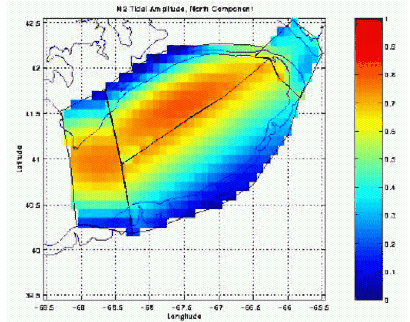
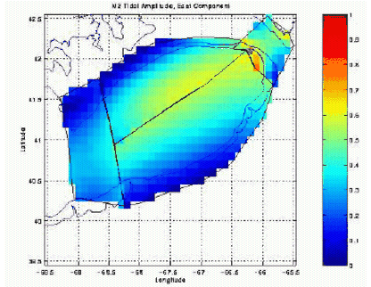
Figure 1. Amplitude of the east and north components of the M2 barotropic tidal current constituent (m/s) as determined using the Candela method for the four regions separately and then composited together.

Figure 2. Record mean barotropic velocities based upon the detided one-hour averaged ADCP currents. The vectors represent the means for those ADCP profiles that fall within each of the poligons, clearly showing the clockwise circulation around the bank, the horizontal shear in the Northeast Channel, the offshore velocity gradient of the southern flank and the north flank jet.