
Report of
RVIB Nathanial B. Palmer Cruise 0202
to the
Western Antarctic Peninsula
9 April to 21 May, 2002
Report prepared by Peter Wiebe, John Klinck, Carin Ashjian, Erik Chapman, Wendy Kozlowski, Dezhang Chu, Rob Masserini, Deb Glasgow, Julian Ashford, Ana Sirovic, Phil Alatalo, Kristin Cobb, and Suzanne O’Hara, with assistance from other colleagues in the scientific party and the Raytheon Support Services. This cruise was sponsored by the Office of Polar Programs at the National Science Foundation.
United States Southern Ocean
Global Ocean Ecosystems Dynamics Program
Report Number 6
Available from
U.S. Southern Ocean GLOBEC Planning Office
Center for Coastal Physical Oceanography
Crittenton Hall
Old Dominion University
Norfolk, VA 23529
Acknowledgments
This cruise, the third in the series of four Southern Ocean GLOBEC broad-scale cruises, was in all measures a great success. The cruise objectives were accomplished as well or better than anticipated and there was time to add additional scientific activities to explore in greater depth some of the cruise findings. The Raytheon Marine Technical support group, led by Alice Doyle, provided excellent assistance in port and at sea. Their very positive attitude and superb technical expertise made the cruise run very smoothly. Captain Joe Borkowski and the officers and crew of the N.B. Palmer were also very supportive. The congenial atmosphere on board the N. B. Palmer made working and living there a great experience.
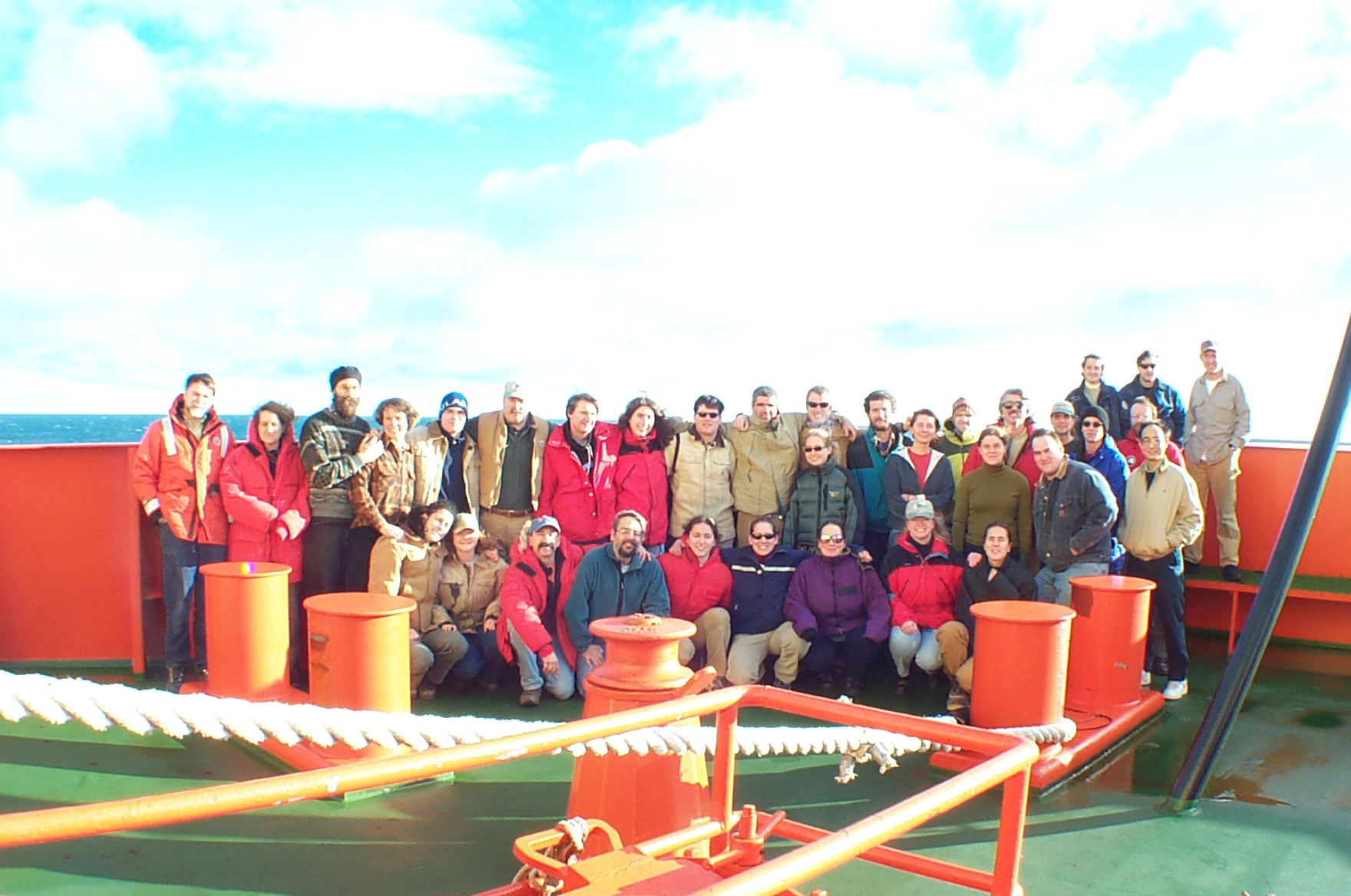
NBP0202 Cruise Participants on the RVIB N.B. Palmer
Kneeling (L-R): Alice Doyle, Jenny White, Phil Alatalo, John Klinck, Ann Sirovic, Amy Kukulya, Deb Glasgow, Helena Martellero, Wendy Kozlowski.
Row 1 (starting right of middle): Gaelin Rosenwaks, Yulia Serebrennikova, Kristy Aller, Andy Girard.
Row 2: Peter Wiebe, Carin Ashjian, Pete Martin, Karen Riener, Phil Taisey, Mark Dennett, Chris MacKay, Kristin Cobb, Erik Chapman, Steve Tarrent, Matthew Becker, Andres Hector Sepulveda, Romeo Laiviera, Sheldon Blackman, Tim Boyer, Rob Masserini, Julian Ashford, Dezhang Chu.
Row 3 (Upper right): Suzanne O’Hara, Kevin Bliss, Stian Alessandrini.
TABLE OF CONTENTS
PURPOSE OF THE CRUISE
CRUISE NARRATIVE
INDIVIDUALS PROJECT REPORTS
1.0 Report for Hydrography, Circulation, and Meteorology Component
1.1 Introduction
1.2 Details of Data Collection
1.2.1 CTD and water samples
1.2.1.1 Salinity Calibration
1.2.1.2 Oxygen Calibration
1.2.2 Expendable Probes
1.2.3 Microstructure Profiler
1.2.4 ADCP Measurements
1.2.5 Meteorology Measurements
1.3 Preliminary Results
1.3.1 Water Mass Distributions
1.3.2 Spatial Distributions and Circulation
1.3.3 Microstructure Results
1.3.4 Surface Fluxes
1.4 Acknowledgments
1.5 References
2.0 Nutrients
2.1 Introduction
2.2 Methods
2.3 Data
2.4 Preliminary Results for Nutrient Concentrations
2.5 References
3.0 Primary Production Component
3.1 Introduction
3.2 Methods
3.2.1 Sampling Locations
3.2.3 Depths
3.2.3 Ice Sampling
3.2.4 Equipment
3.2.5 Data Collected
4.0 Zooplankton Studies
4.1 Zooplankton Sampling with the 1m2 MOCNESS Net System
4.1.1 Introduction
4.1.2 Methods and Approach
4.1.3 Preliminary Findings
4.1.4 Acknowledgments
4.2 BIOMAPER-II Survey
4.2.1 Acoustics Data Collection, Processing, and Results
4.2.1.1 Introduction
4.2.1.2 Methods
4.2.1.3 Results
4.2.3 Video Plankton Recorder
4.2.3.1 Overview
4.2.3.2 Methods
4.2.3.3 The VPR system
4.2.3.3.1
4.2.3.3.2
4.2.3.3.3 Video Recording and Processing
4.2.3.3.4 Plankton Abundance and Environmental Data
4.2.3.3.5 Sampling
4.2.3.4 Results
4.2.3.4.1 Planktonic Taxa Observed with the VPR
4.2.3.5 Discussion
4.2.3.5.1 Plankton Distributions
4.2.4 Water column hydrographic and environmental characteristics
4.2.4.1 Overview
4.2.4.2 Distributional Patterns of Environmental Data
4.2.5 Acknowledgments
4.3 ROV observations of juvenile krill distribution, abundance, and behavior
4.3.1 Objective
4.3.2 Methods
4.3.3 Results
4.4 Microplankton Studies
4.4.1 Introduction
4.4.2 Methods
4.4.3 Preliminary Results
5.0 Material Properties Of Zooplankton
5.1 Introduction
5.2 Methods and Instruments
5.2.1 Sound speed contrast measurements
5.2.2 Density contrast measurements
5.3 Data Collection and Preliminary Results
5.3.1 Data collection
5.3.2 Preliminary Results
5.3.3 Calibration
5.3.4. References
6.0 Seabird and Crabeater Seal Distribution in the Marguerite Bay Area
6.1 Introduction
6.2 Methods
6.3 Daytime Surveys
6.3.1 Methods
6.3.2 Data Collected
6.3.3 Preliminary Results
6.3.3.1 Ice Condition
6.3.3.2 Birds
6.3.3.3 Adelie Penguin (Pygoscelis adeliae)
6.3.3.4 Crabeater Seals (Lobodon carcinophagus)
6.3.4 Diet Sampling
6.3.4.1.Methods
6.3.4.2 Data Collected
6.3.4.3 Preliminary Results
6.3.5 Surface Net Tows
6.3.5.1 Introduction
6.3.5.2 Methods
6.3.5.3 Data Collected/Preliminary Results
6.3.6 General Discussion
8.0 Marine Mammals Passive Acoustics
8.2 Methods
8.3 Data Collected
8.4 Preliminary Results
9.0 Fish Otolith Collections
10.0 Science Writer Report
11.0 Seabeam bathymetry of region and Mooring surveys
CRUISE PARTICIPANTS
Appendix 1. Event Log.
Appendix 2. Summary of CTD casts
Appendix 3. Summary of water samples
Appendix 4. Summary of salinity measurements
Appendix 5. Summary of oxygen titrations
Appendix 6. Summary of expendable probes
Appendix 7. Video and Lugol's Samples Taken on NBP0202
Appendix 8. Summary of sightings
Appendix 9. Results from analysis of fourteen diet samples of Adelie Penguins
Appendix 10. 1-m Ring Net Tow Information.
Appendix 11. BIOMAPER-II Tape Log.
Appendix 12. Cetacean Sightings NBP0202 9 April to 21 May 2002
The U.S. Southern Ocean GLOBEC Program is in its second field year. The focus of this study is on the biology and physics of a region of the continental shelf to the west of the Western Antarctic Peninsula extending from the northern tip of Adelaide Island to the southern portion of Alexander Island and including Marguerite Bay. The primary goals are:
1) To elucidate shelf circulation processes and their effect on sea ice formation and Antarctic krill (Euphausia superba) distribution.
2) To examine the factors that govern krill survivorship and availability to higher trophic levels, including seals, penguins, and whales.
The second year field program began with a mooring cruise in February and March aboard the R/V L.M. Gould during which a series of moorings deployed a year ago across the continental shelf of the Adelaide Island and across the mouth of Marguerite Bay were recovered (LMG02-1A Cruise Report). The Marguerite Bay moorings were reset in slightly different positions. In addition the series of bottom mounted moorings instrumented to record marine mammal calls and sounds were recovered and reset. This report describes and details the first broad-scale cruise to take place this year (the third in a series of four). Our effort is mainly devoted to developing a shelf-wide context for the process work being conducted during this same time period aboard the R/V L.M. Gould and for the modelers who will be using both the broad-scale and the process data in their model computations. Our specific objectives with regard to the broad-scale survey were:
1) To conduct a broad-scale survey of the SO GLOBEC Study Site to determine the abundance and distribution of the target species, Euphausia superba and its associated flora and fauna.
2) To conduct a hydrographic survey of the region.
3) To collect physical microstructure data from the water column.
4) To collect chlorophyll data, nutrient data, and to make primary production measurements to characterize the primary production of the region.
5) To collect zooplankton samples with a MOCNESS at selected locations throughout the broad-scale sampling area.
6) To survey the under ice distribution and abundance of krill larvae using an ROV equipped with a VPR, ADCP, and CTD.
7) To survey the sea birds throughout the broad-scale sampling area and determine their feeding patterns.
8) To survey the marine mammals throughout the broad-scale sampling area both by visual sightings and by passive listening techniques.
9) To map the bank-wide velocity field using an Acoustic Doppler Current Profiler (ADCP).
10) To collect acoustic, video, and environmental data along the tracklines between stations using a suite of sensors mounted in a towed body (BIOMAPER-II).
11) To collect meteorological data.
12) To deploy satellite tracked drogues at four locations on the station grid.
In addition, an ancillary program was conducted to study the sound speed contrast and the density contrast of zooplankton in the region, with principal focus on Antarctic krill.
The cruise track was determined by the positions of 92 station locations distributed along 13 transect lines running across the continental shelf and perpendicular to the Western Peninsula coastline (Figures 1, 2). The work was a combination of station and underway activities (See the Event Log, Appendix 1). The along-track data were collected from the BIo-Optical Multifrequency Acoustical and Physical Environmental Recorder (BIOMAPER-II), the ADCP, the meteorological sensors, through hull sea surface sensors, XBTs, XCTDs, and Sonabuoys. At the stations, a cast with a CTD/Rosette equipped with oxygen, transmissometer, and fluorometer sensors was made to the bottom. In water depths less than about 500 m, a Fast Repetition Response Fluorometer (FRRF) was added to the Rosette and at some deep water locations, a special cast to 100 m was made with it on before doing the deep cast. In addition, a sensor system to measure microstructure, CMiPS, was installed on the CTD and it was used on most CTD casts that were shallower than about 2000 m. At selected stations, a 1-m2 Multiple Opening/Closing Net and Environmental Sensing System (MOCNESS) was towed obliquely between the surface and near the bottom or 1000 m if the bottom were deeper for collection of zooplankton (335 um mesh). A 1-m Reeve net was used to make collections of live animals for use in shipboard acoustic experimental studies and a 1-m ring net was used for surface zooplankton collections for use in sea bird feeding studies. Meteorological, sea surface hydrographic properties, and SeaBeam bathymetry data were collected along the survey tracklines.
Note: all times given in the text are local times, which were +4 UTC time.
This narrative is an excerpt of reports usually sent in daily from the N.B. Palmer to the Southern Ocean GLOBEC Web Site located at: www.ccpo.odu.edu/Research/globec/main_cruises02/nbp0202/menu.html. These reports provide additional detail about the activities that took place on the cruise.
April 9-11: The RVIB N.B. Palmer left the port of Punta Arenas, Chile at 1100 hours on Tuesday, 9 April 2002 after an intensive week of cruise preparation, which went very smoothly thanks to the excellent preparations and assistance provided by the Raytheon Technical Support Group. There was a moderate wind and partly cloudy skies.
Shortly after leaving port, we stopped at a nearby dock to pick up the “Cajon Cruncher”, a small boat carried by the N.B. Palmer, which had undergone some repairs in Punta Arenas. After lunch, we had our first safety meeting with Chief Mate Richard Wishner presiding. This included dawning the survival suits and the exercise of getting the entire science party into a large life boat and strapped in. The safety meeting was followed by a science meeting led by MPC Alice Doyle and Chief Scientist Peter Wiebe. Then, there was an on deck safety briefing and later a SeaBeam data ping editing class for those who had not previously done ping editing. Later in the afternoon, while steaming through the straits of Magellan, we slowed for a test deployment of BIOMAPER-II. This enabled those who handled the launch and recovery of the towed body during the cruise to become familiar with the procedures in running the winch, slack tensioner, and overboarding sheave and docking mechanism together with the operation of the stern A-frame under good weather and sea conditions. It also provided an in-water test of all of the sensors systems while the system was being towed and fine tuning of the weight distribution in towed body to get it to tow horizontally. Around 1800 at the pilot drop-off point on the eastern end of the Straits of Magellan, three individuals (Sam Johnson of HTI, and Scott Gallager and Terry Hammar both from WHOI) who were assisting in the port setup of the hardware and software associated with BIOMAPER-II and the ROV, left the ship along with the pilot.
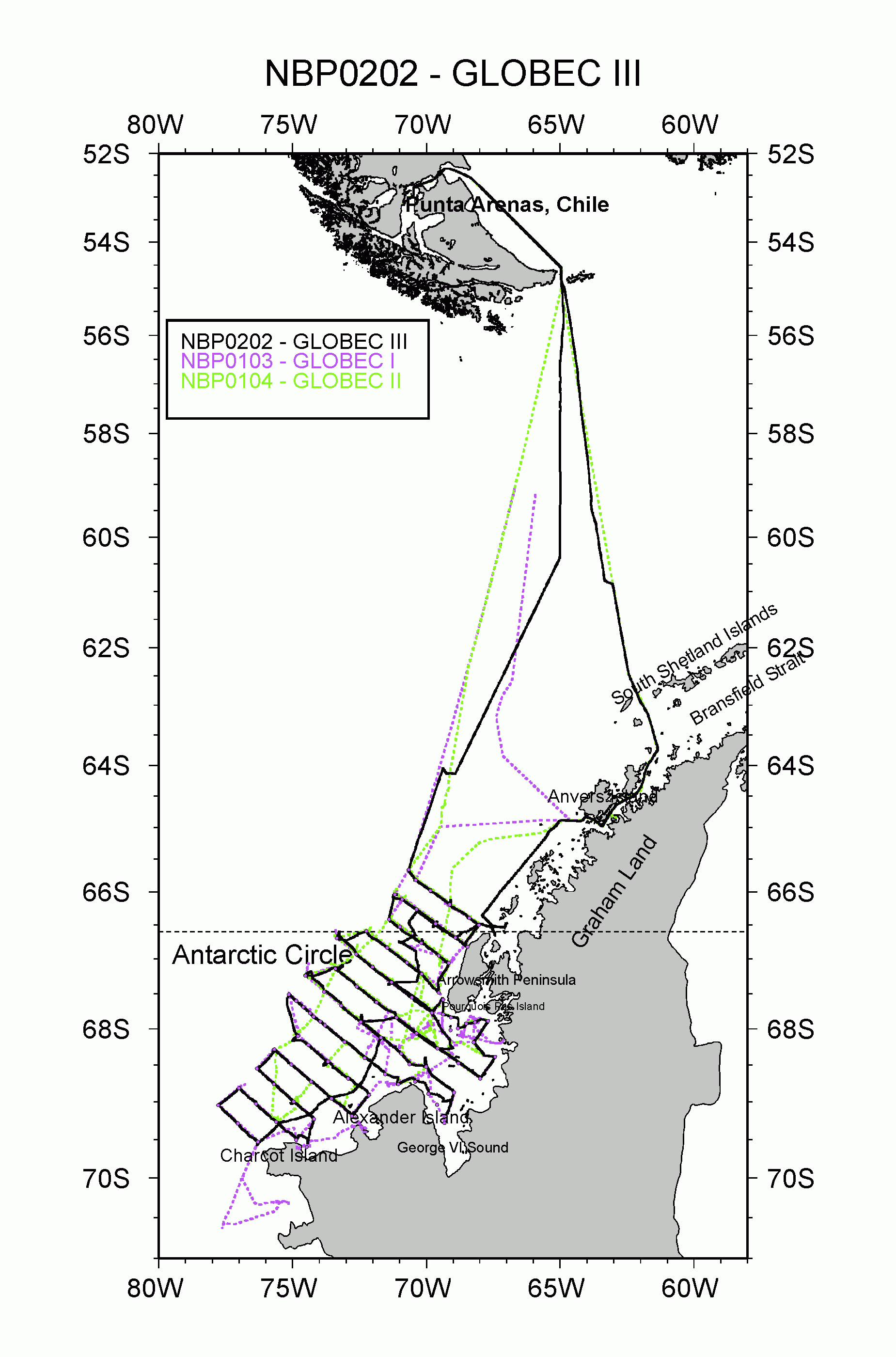
Figure 1. RVIB Nathanial B. Palmer (NBP0202) cruise track (solid black line) and cruise tracks from the previous two Southern Ocean GLOBEC broad-scale surveys. Figure prepared by S. O’Hara.
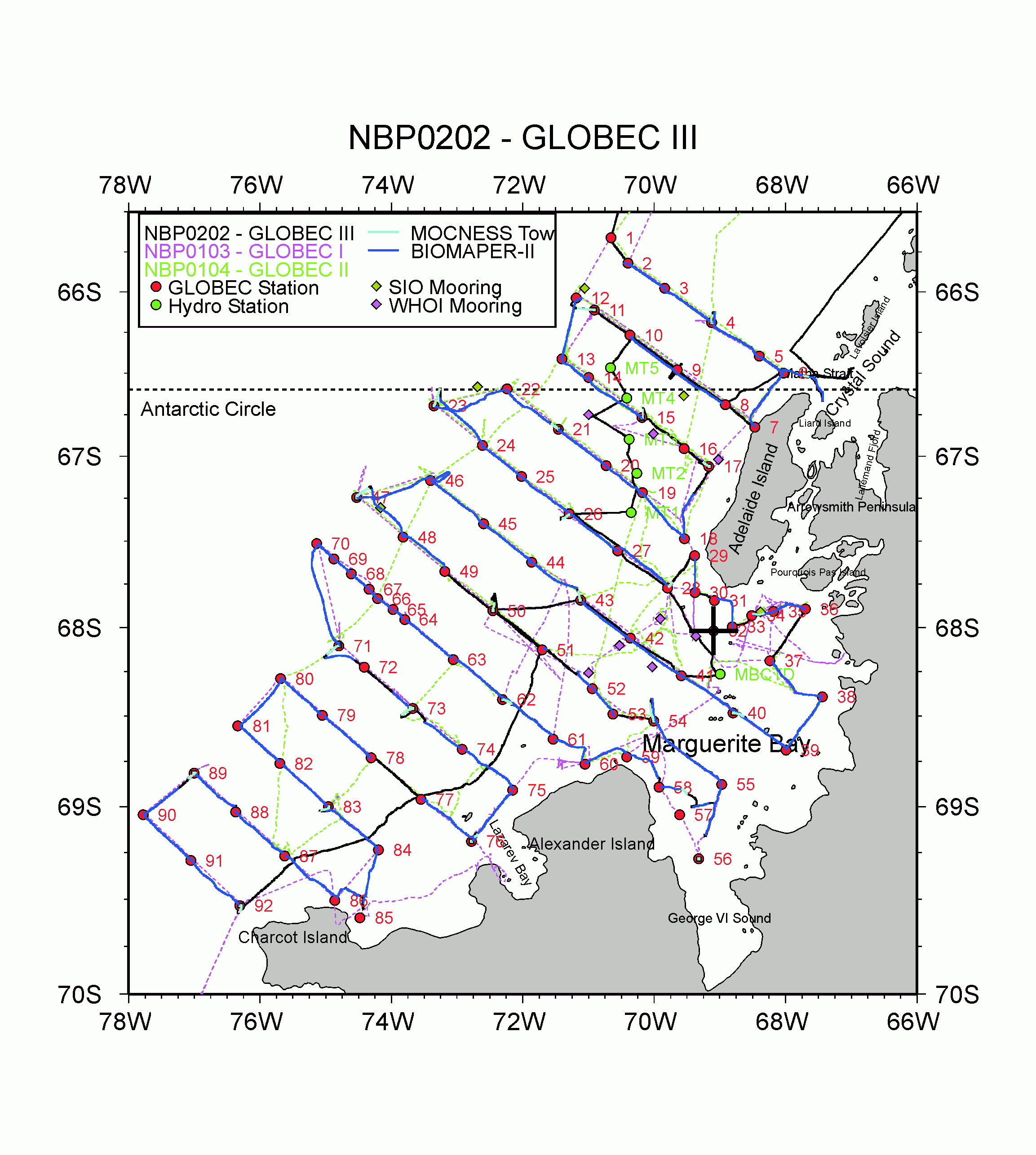
Figure 2. The Southern Ocean GLOBEC broad-scale survey grid and trackline, showing locations of stations and along-track observations. Locations of specific activities are in the individual reports and in the event log (Appendix 1). Previous broad-scale cruise tracklines are indicated as dashed lines. Figure prepared by S. H.