NBP0103
GLOBEC I
April 23, 2001 – June 6, 2001
United States Antarctic Program
RVIB Nathaniel B. Palmer
Raytheon Polar Services Company
June 6, 2001
Data Report Prepared by, Aaron Hunt, Tom Bolmer & Jim Dolan
Introduction
*Archive Data Extraction
*Distribution Contents
*ADCP
*CTD
*Cruise Track
*NBP Data Products: MGD77 & JGOFS
*JGOFS
*MGD77
*RVDAS
*Data File Names and Structures
*Ocean Data Files
*PROCESSING RAW TSG DATA
*Additional & Supplemental Files
*Additional Files
*NBP0103 Sensors
*Shipboard Sensors
*0103 CTD Sensors:
*0103 ROV Sensors:
*0103 MOCNESS Sensors:
*Acquisition Problems and Events
*Calibrations
*Barometer
*Pyranometer/PSP
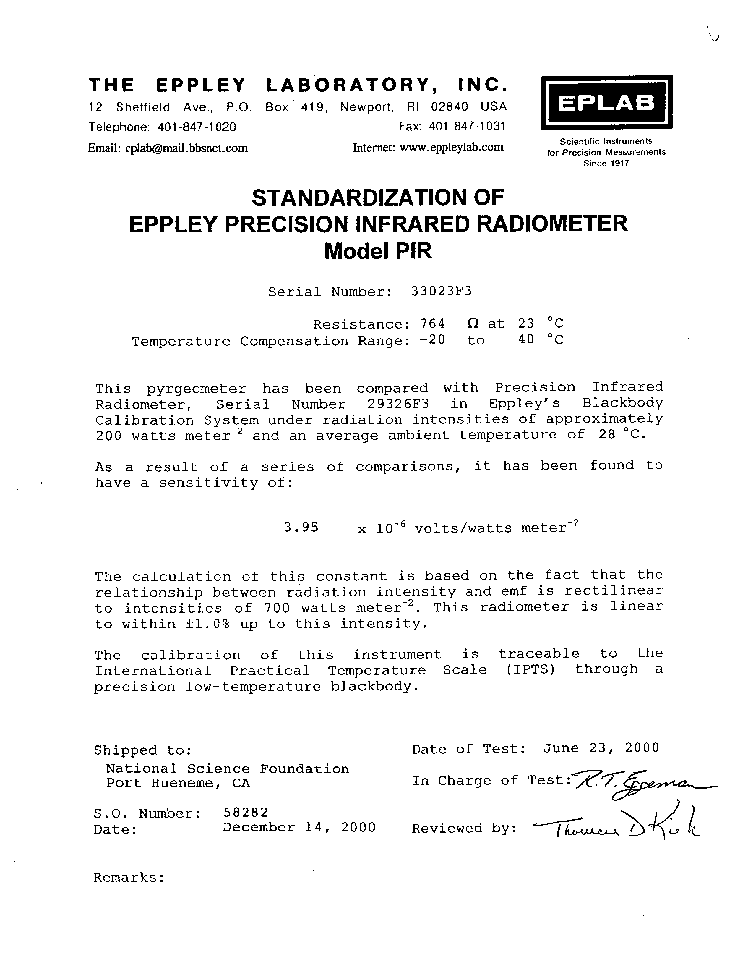
*Radiometer/PIR
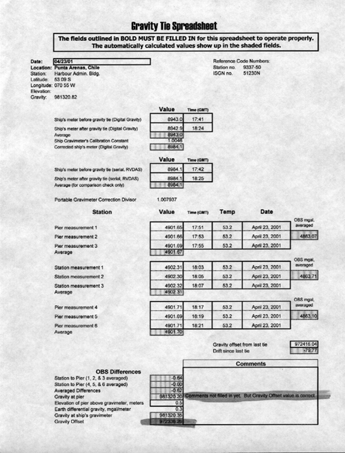
*Gravity Tie
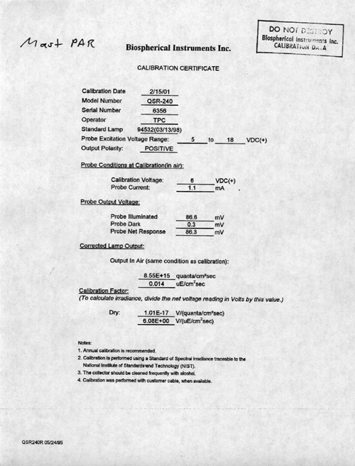
*Mast Par
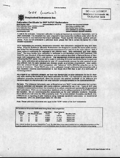
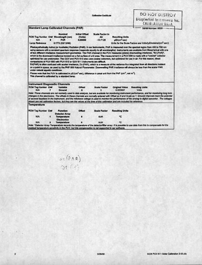
*GUV
*GUV
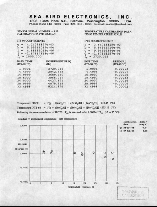
*Thermosalinograph
*TSG Internal
*TSG External
*Temperature/Humidity Sensor
*Belfort Wind Vector Transmitter
*CTD Instruments
*Transmissometer
*Underwater PAR Sensor
*Fluorimeter
*Flourimeter
*Fluorimeter
*Fluorimeter
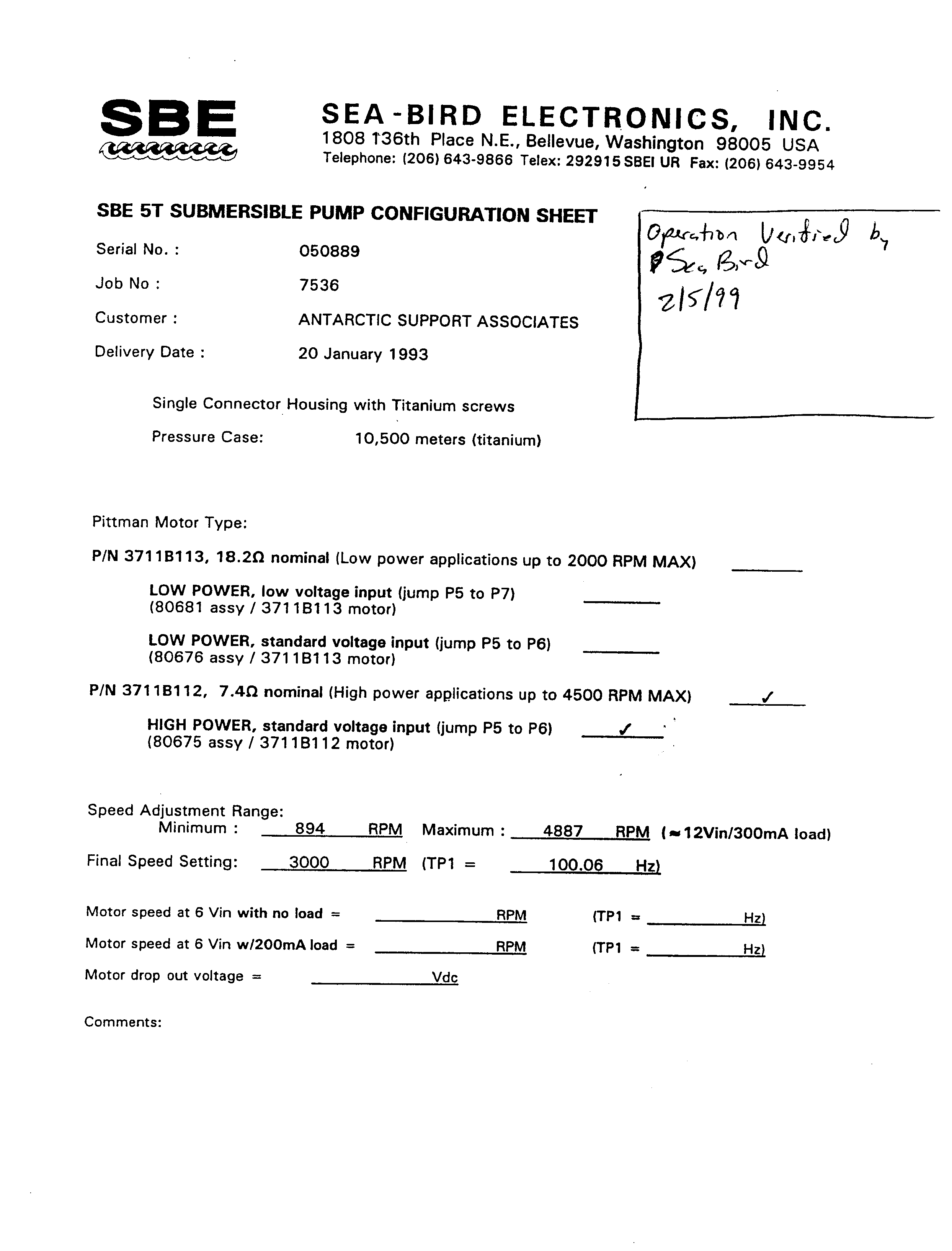
*SBE 5T Submersible Pump Serial No: 050889
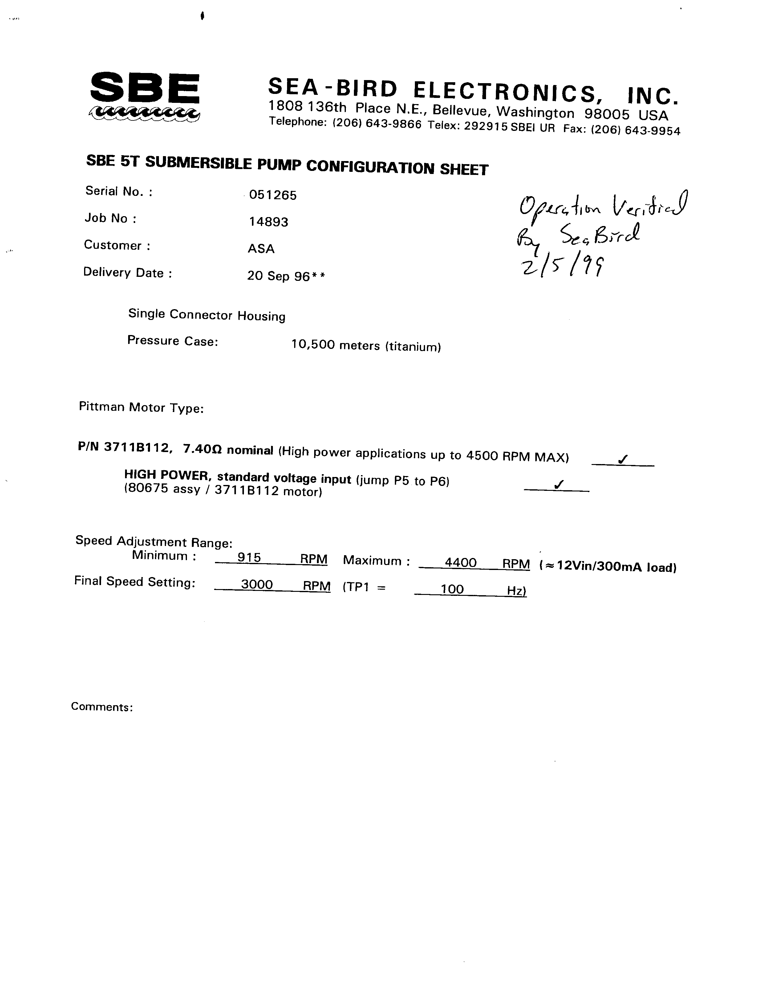
*SBE 5T Submersible Pump Serial No:051265
*Pressure Sensor
*Dissolved Oxygen Sensor Serial No: 130327
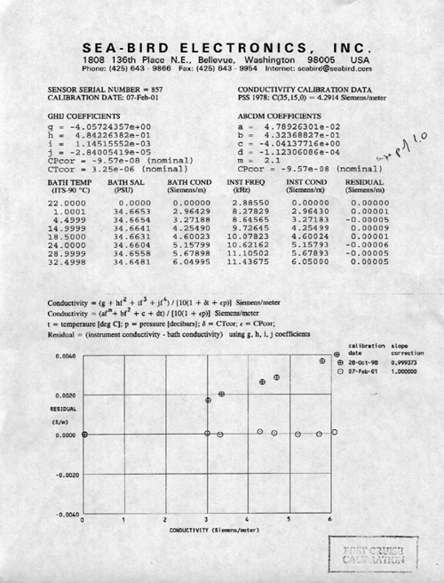
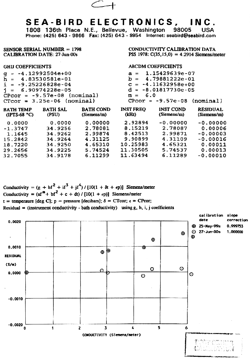
*Conductivity Sensor (Primary)
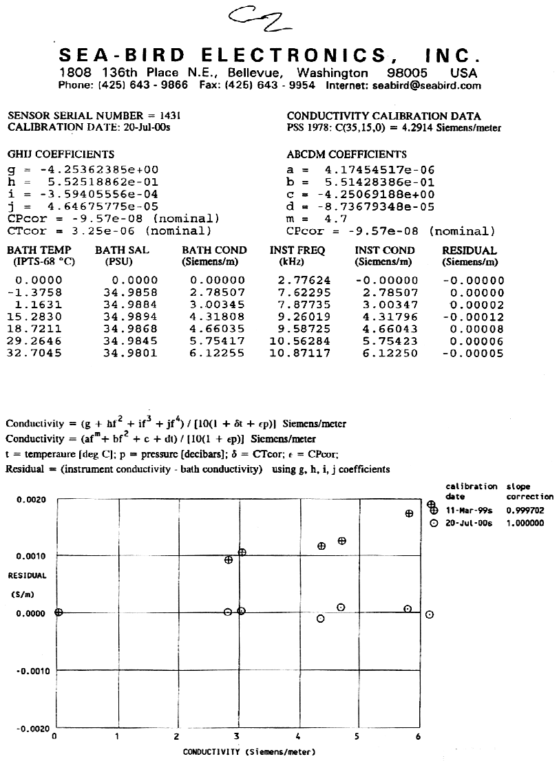
*Conductivity Sensor (Secondary)
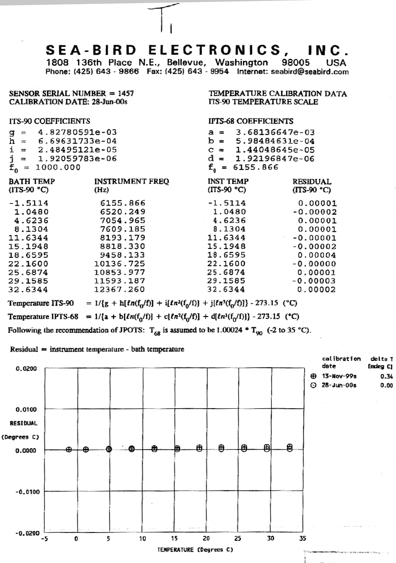
*Temperature Sensor (Primary)
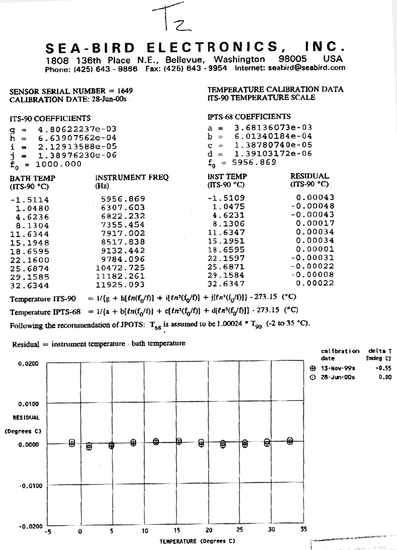
*Temperature Sensor (Secondary)
*Underwater PAR Sensor (1st five casts)
*Underwater PAR Sensor (Starting 6th Cast)
*ROV Sensors
*Pressure Sensor
*Conductivity
*Temperature
*MOCNESS Calibrations
*Pressure Sensor
*Pressure Sensor
*Temperature
*Conductivity
*Dissolved Oxygen
*C-Star
*Fluorometer
*Fluorometer
*The NBP data acquisition systems continuously log data from several instruments throughout the cruise. This document describes the format of that data and its location on the distribution DAT tapes. It also contains important information which may affect how this data is processed such as instrument failures or other known problems with acquisition.
The data collected during this cruise is distributed on a CD-ROM written in ISO9660 level-1 format. This data format has very strict requirements on filenames and organization. However, it is readable by virtually every computing platform.
The data is contained in a Unix tar archive called NBP0103.tar. All of the data has been compressed using Unix "gzip" compression. Gzipped files have a ".gz" extension. Tools are available on all platforms for uncompressing and de-archiving these formats. On Macintosh, Stuffit Expander with DropStuff will open a tar archive and uncompress gzipped and Unix compressed files. For Windows9X, WinZip, a shareware utility included on this CD (remember, it is shareware) will open these files.
IMPORTANT: Read the last section in this document, Acquisition Problems and Events, for important information that may affect the processing of this data.
It is often useful to know exactly how an archive was produced when expanding its contents. NBP0103.tar was created on an SGI using the following commands:
tar cvLf archive-file files-to-be-archived
To create a list of the files in the archive:
tar tvf archive-file > contents.list
To extract the files from the archive:
tar xvf archive-file file(s)-to-extract
G-zipped files will have a ".gz" extension on the filename. These files can be decompressed after de-archiving, using:
gunzip filename.gz
The directories in the archive are structured in the following manner:
|
CD 1 of 2 |
CD 1 of 2 continued |
|
NBP0103.GMT NBP0103.MGD NBP0103.TRK NBP0103.ps TOMPLOT.ps.gz EVENTLOG.gz ADCP/ 0103ADCP.tar 0103PING.zip GEOPDATA/ 0103BAT.tar 0103GRV.tar 0103JGOF.tar 0103MAG.tar 0103NGL.tar 0103PCD.tar 0103PS.tar 0103SB.tar 0103SIM.tar 0103TSG.tar OCEAN/ CTD/ 0103PROC.tar 0103RAW.tar 0 103PCO2.tar0103TSGF.tar 0103XBT.tar 0103GUV.tar 0103XCTD.tar REPORT/ 0103DATA.doc 0103DATA.htm 0103DATA.txt CD_cases CALIBRAT/ INSTRMNT.CNF |
RVDAS/ NAV/ 0103PCOD UW/ 0103BAR.tar 0103BAT.tar 0103FLR.tar 0103GRV.tar 0103MAG.tar 0103MET.tar 0103PCO2.tar 0103SIM.tar 0103SVP.tar 0103TSG.tar
CD 2 of 2 RVDAS/ NAV/ 0103ADCP.tar 01033DF.tar 0103GYR.tar 0103PCOD.tar 0103NGL.tar WINZIP ADDITION/ 0103ESS.tar 0103MET.tar
|
The ADCP data set is broken up into files representing 24 hours of data collection. The files are named pingdata.xxx (xxx representing a day number). Note that these extensions do NOT represent Julian day numbers. Please refer to the file’s creation date.
Some ADCP data is also transmitted to RVDAS. East and North vectors for ship’s speed relative to the reference layer and ship’s heading are archived in the navigational data section of RVDAS.
CTD
The ctd data and report have been placed in the tar file 0103ctd.tar, which contains the following structure:
ctdlist.txt (list of all ctd stations)
ctdsetup (batch files, cfg & con files)
0103Raw (raw datafiles)
0103Proc (processed data files)
seasoft (application for processing CTD data
Individual CTD casts are represented by a set of four files containing a bottle-firing file (.bl), a configuration file (.con), a data file (.dat) and a header file (.hdr). Casts are numbered according to the cruise id number (0103) followed by the number of the cast. For example; the raw files associated with the third cast on this cruise are: 0103003.bl, 0103003.con, 0103003.dat, 0103003.hdr. The raw and processed data files are in binary format. The 1 db bin averaged up and down traces have been converted to ASCII (.asc files).
SeaBird’s SeaSoft software used to acquire the data is included in the CTD data distribution in the "Seasoft" directory. SeaSoft is a DOS-based software package, but can be run in a DOS window under the Windows9X operating systems for cast playback and data analysis. The software package used to process this data (version 4.234) is included on this CD in the directory Seasoft. The configuration files and processing scripts (written by Suzanne O’Hara for the standard processing of the SBE 9/11plus) are also included in the Seasoft directory under in the ctdsetup directory. The directory report contains the CTD data report with folder for all plots produced during the cruise. The directory seacat has a structure similar to the ctd directory and contains the data from the SeaCat CTD unit.
File extension definitions:
|
EXT |
Description |
|
ASC |
The data portion of a .CNV converted data file written in ASCII by ASCIIOUT, or files written by TERM37. |
|
BL |
Created by SEASAVE when a bottle fire confirmation is received. Contains bottle sequence number, position, date, time, beginning and ending scan numbers. |
|
BTL |
Created by ROSSUM. This is a summary of the data in a .ROS file. |
|
BSR |
Bottle scan range file, used by DATCNV to create a .ROS file. |
|
CFG |
Used by SEASOFT modules to store the input filename, input data path, output data path, and other miscellaneous module specific parameters. |
|
CTR |
Density contour file generated by CONTOUR. |
|
CNV |
‘Converted’ engineering unit data file. An ASCII header precedes the data. |
|
CON |
Contains instrument configuration and calibration coefficients, used by SEACON, SEASAVE, and DATCNV |
|
DAT |
Raw binary data, optionally with header information (SBE 9/11, 11X, 9/11plus, and data files created with previous versions of SEASOFT). |
|
DSP |
Used by SEASAVE to store data acquisition and display parameters. |
|
HDR |
2) Header recorded when acquiring real time data or uploading archived data. |
|
HEX |
Raw HEX data with header information (SBE 16, 17, 19, 21, and 25) |
|
MRK |
Marker file created by SEASAVE during real time data acquisition. |
|
PLT |
Used by SEAPLOT to store display parameters |
|
ROS |
Scans marked with the bottle fire confirmation bit, or defined by a .BSR file, written by DATCNV. |
*Note: This is a complete list of all file extensions. This data set may not contain ALL of the above extension files.
SEASOFT modules search the current directory for DSP, PLT, and CFG files. SEASOFT modules search the ‘input data path’ for CON, HEX, DAT, and CNV files. One exception is SEACON which searches the current directory for CON files.
For more information and updated software visit the web site at
www.seabird.com; or contact (206) 643-9866, seabird@seabird.com, Sea-Bird Electronics 1808 – 136th Place NE Bellevue, WA 98005A Postscript cruise track file has been produced for this cruise called NBP0103.ps. It is a standard US Letter sized (8.5" x 11") plot. A GMT cruise track file (NBP0103.trk) is also included, which contains the longitude and latitude at one-minute intervals extracted from the NBP0103.gmt file.
NBP Data Products: MGD77 & JGOFS
NBP0103.mgd
NBP0103.gmt
/geopdata/JGOF
/geopdata/PROC
Two data products are created on each cruise of the NBP: JGOFS and MGD77.
The JGOFS data set consists of a single file produced each day named jgDDD.dat.gz where DDD is the Julian day the data was acquired. The ".gz" extension indicates that the individual files are compressed before archiving. The daily file consists of 20 separate columnar fields in text format, which are described below. The JGOFS data set is obtained primarily by applying calibrations to raw data and decimating to whole minute intervals. However, several fields are derived measurements from more than a single raw input. For example, Course Made Good (CMG) and Speed Over Ground (SOG) are calculated from gyro and GPS inputs by the NGL software package. Similarly, the wind direction field is the vector sum of the separate X and Y inputs received from the wind instruments. The JGOFS data set was used to produce the daily data plots during the cruise. Note: Null, unused, or unknown fields are filled with 9’s in the JGOFS data. TSG data is processed by RVDAS.
|
Field |
Data |
Units |
|
01 |
GMT date |
dd/mm/yy |
|
02 |
GMT time |
hh:mm:ss |
|
03 |
NGL latitude (negative is South) |
dd.dddd |
|
04 |
NGL longitude (negative is West) |
ddd.dddd |
|
05 |
speed over ground |
Knots |
|
06 |
GPS HDOP |
- |
|
07 |
Gyro Heading |
Degrees (azimuth) |
|
08 |
course made good |
Degrees (azimuth) |
|
09 |
mast PAR |
m Einsteins/meters2 sec |
|
10 |
sea surface temperature |
° C |
|
11 |
sea surface conductivity |
siemens/meter |
|
12 |
sea surface salinity |
PSU |
|
13 |
sea depth (uncorrected, calc. sw sound vel. 1500 m/s) |
meters |
|
14 |
true wind speed (port windbird) |
meters/sec |
|
15 |
true wind direction (port windbird) |
degrees (azimuth) |
|
16 |
ambient air temperature |
° C |
|
17 |
relative humidity |
% |
|
18 |
barometric pressure |
mBars |
|
19 |
sea surface fluorometry |
volts (0-5 FSO) |
|
20 |
not used |
- |
The MGD77 data set is contained in a single file for the entire cruise named NBP0103.mgd, There is also a file named NBP0103.gmt. This file is the output of the mgd77togmt utility using NBP0103.mgd as input. The "gmt" file can be useful for plotting data using the GMT plotting package. The directory /geopdata/PROC contains a file from each day of data acquisition named: Dddd.fnl.gz, where ddd is the Julian day. These files contain all the data used to produce the "mgd" file, but in a space-delimited columnar format that may be more accessible for some purposes. In addition, these files contain data at one-second intervals rather than one minute and are individually "gzipped" to save space. Below is a detailed description of the MGD77 data set format.
All decimal points are implied. Leading zeros and blanks are equivalent. Unknown or unused fields are to be filled with 9’s. All "corrections", such as time zone, diurnal magnetics, and Eotvos, are understood to be added.
|
Col |
Len |
Type |
Description |
|
1 |
1 |
int |
DATA RECORD TYPE Set to "3" for data record. |
|
2-9 |
8 |
char |
SURVEY IDENTIFIER |
|
10-14 |
5 |
int |
TIME-ZONE CORRECTION: In hundredths of hours. Corrects time (in characters 13-27) to GMT when added: equals zero when time is GMT. |
|
15-16 |
2 |
int |
YEAR 2 digit year |
|
17-18 |
2 |
int |
MONTH (e.g. May is represented as 05) |
|
19-20 |
2 |
int |
DAY Day of month |
|
21-22 |
2 |
int |
HOUR |
|
23-27 |
5 |
real |
MINUTES X 1000 |
|
28-35 |
8 |
real |
LATITUDE X 100000 + = North; - = South. (–9000000 to 9000000) |
|
36-44 |
9 |
real |
LONGITUDE X 100000 + = East; - = West. (–18000000 to 18000000) |
|
45 |
1 |
int |
POSITION TYPE CODE: 1=Observed fix; 3=Interpolated; 9=Unspecified |
|
46-51 |
6 |
real |
BATHYMETRY, 2- WAY TRAVELTIME: In 10,000th of seconds. Corrected for transducer depth and other such corrections |
|
52-57 |
6 |
real |
BATHYMETRY, CORRECTED DEPTH: In tenths of meters. |
|
58-59 |
2 |
int |
BATHYMETRIC CORRECTION CODE: This code details the procedure used for determining the sound velocity correction to depth |
|
60 |
1 |
int |
BATHYMETRIC TYPE CODE: 1 = Observed; 3 = Interpolated (Header Seq. 12); 9 = Unspecified |
|
61-66 |
6 |
real |
MAGNETICS TOTAL FIELD, 1ST SENSOR: In tenths of nanoteslas (gammas). |
|
67-72 |
6 |
real |
MAGNETICS TOTAL FIELD, 2ND SENSOR: In tenths of nanoteslas (gammas). For trailing sensor. |
|
73-78 |
6 |
real |
MAGNETICS RESIDUAL FIELD: In tenths of nanoteslas (gammas). The reference field used is in Header Seq. 13. |
|
79 |
1 |
int |
SENSOR FOR RESIDUAL FIELD 1 = 1st or leading sensor; 2 = 2nd or trailing sensor; 9 = Unspecified |
|
80-84 |
5 |
real |
MAGNETICS DIURNAL CORRECTION: In tenths of nanoteslas (gammas). (In nanoteslas) if 9-filled (i.e., set to "+9999"), total and residual fields are assumed to be uncorrected; if used, total and residuals are assumed to have been already corrected. |
|
85-90 |
6 |
F6.0 |
DEPTH OR ALTITUDE OF MAGNETICS SENSOR: In meters. + = Below sea level 3 = Above sea level |
|
91-9 |
7 |
real |
OBSERVED GRAVITY: In 10th of mgals. Corrected for Eotvos, drift, tares. |
|
98-10 |
6 |
real |
EOTVOS CORRECTION: In tenths of mgals. E = 7.5 V cos phi sin alpha + 0.0042 V*V |
|
104-108 |
5 |
real |
FREE-AIR ANOMALY In tenths of milligals Free-air Anomaly = G(observed) – G(theoretical) |
|
109-113 |
5 |
char |
SEISMIC LINE NUMBER: Used for cross-referencing with seismic data. |
|
114-119 |
6 |
char |
SEISMIC SHOT-POINT NUMBER |
|
120 |
1 |
int |
QUALITY CODE FOR NAVIGATION: 5=Suspected, by the originating institution;6=Suspected, by the data center, 9=No identifiable problem found |
rvdas/uw
rvdas/nav
Daily data processing of the RVDAS data is performed to convert values into usable units and as a check of the proper operation of the DAS. Both the raw and processed data sets from RVDAS are included in the data distribution. Below you will find detailed information on the data included. Be sure to read the "Significant Acquisition Events" section below for important information about data acquisition during this cruise.
|
Measurement |
File ID |
Collect. Status |
Rate |
Instrument |
|
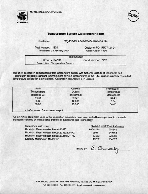
Air Temperature |
met1 |
continuous |
0.5 sec |
R. M. young 41342C |
|
Relative Humidity |
met1 |
continuous |
0.5 sec |
Rotonics MP-101A-C4 |
|
Wind Speed/Direction |
met1 |
continuous |
0.5 sec |
Belfort Model 5-122AHD |
|
PIR (LW radiation) |
met1 |
continuous |
0.5 sec |
Eppley PIR |
|
PSP (SW radiation) |
met1 |
continuous |
0.5 sec |
Eppley PSP |
|
PhotoActive Radiation |
met1 |
continuous |
0.5 sec |
BSI QSR-240 |
|
Barometer |
bar1 |
continuous |
9 sec |
AIR-DB-3A |
|
Measurement |
File ID |
Collect. Status |
Rate |
Instrument |
|
Attitude GPS |
3df1 |
continuous |
1 sec |
Ashtec 12 |
|
P-Code GPS |
PCOD |
continuous |
1 sec |
Trimble 20636-00SM |
|
Gyro |
gyr1 |
continuous |
0.2 sec |
Yokogawa Gyro |
|
NGL |
ngl1 |
continuous |
1 sec |
NGL Processed Nav Data |
|
Measurement |
File ID |
Collect. Status |
Rate |
Instrument |
|
Gravimeter |
grv1 |
continuous |
1 sec |
Lacoste & Romberg Gravity |
|
Magnetometer |
mag1 |
transit |
15 sec |
EG&G G-866 |
|
Bathymetry |
bat1 |
continuous |
varies |
ODEC Bathy 2000 |
|
Bathymetry |
sim1 |
depth < 2500 m |
varies |
Simrad EK200 Sonar |
|
Measurement |
File ID |
Collect. Status |
Rate |
Instrument |
|
Conductivty |
tsg1 |
continuous |
15 sec |
SeaBird 21 |
|
Salinity |
tsgfl |
continuous |
15 sec |
calculated from conductivity |
|
Sea S Temperature |
tsg1 |
continuous |
15 sec |
SeaBird 3-01/S |
|
Fluorometry |
flr1 & tsg1 |
continuous |
15 sec |
Turner 10-AU-005 |
|
pCO2 |
pco2 |
continuous |
70 sec |
|
|
ADCP |
adcp |
continuous |
1 sec |
RD Instruments |
Data File Names and Structures
RVDAS data is divided into two broad categories, Underway and Navigation. The groups are abbreviated "uw" and "nav". Thus, these two subdirectories exist under the top-level rvdas directory. The instruments are broken down as shown. Each data file is gzipped to save space on the distribution. Not all data types are collected everyday or on every cruise.
RVDAS data files are named following the convention: NBP[CruiseID][ChannelID].dDDD.
|
Underway Data |
Channel ID |
|
Navigation Data |
Channel ID |
|
Barometer |
bar1 |
|
Ashtech GPS |
3df1 |
|
Bathy 2000 |
bat1 |
|
Trimble GPS (P-Code) |
PCOD |
|
Fluorometer |
flr1 |
|
Gyro Compass |
gyr1 |
|
Gravimeter |
grv1 |
|
Furuno GPS |
gp02 |
|
Magnetometer |
mag1 |
|
NGL |
ngl1 |
|
Meteorological |
met1 |
|
ADCP course |
adcp |
|
Simrad |
sim1 |
|
|
|
|
Thermosalinograph |
tsg1 |
|
|
|
|
pCO2 |
pco2 |
|
|
|
Data is received by the RVDAS system via RS-232 serial connections. The data files that comprise the rvdas data set are described below. A time tag is added to each line of data received and the data is written to disk.
YY+DDD:HH:MM:SS.SSS [data stream from instrument]
Where, YY: two-digit year, DDD: Julian Day, HH: 2 digit hours, MM: 2 digit minutes SS.SSS: seconds. All times are UTC.
The delimiters used to separate fields in the raw data files are usually spaces and commas, but other delimiters are used (::, =, @) and occasionally there is no delimiter. Care should be taken when reprocessing the data that the fields separations are clearly understood. An example data file:
bar1
00+019:23:59:57.441 963.25
|
Field |
Data |
Units |
|
1 |
Time Tag |
|
|
2 |
Pressure |
mBar |
bat1
00+019:23:59:53.901 ;I04485.3ME-23.0,I00000.0,-99.9, 0000@01/11/00,23:59:52.08 PW2 PF1 SF1 PL3 MO4 SB3 PO0 TX1 TR: GM5 1500 06.7 -72.1
|
Field |
Data |
Units |
|
1 |
RVDAS Time Tag |
|
|
2 |
Flagged Low Freq. Chn. Depth w/ units ;FDDDDD.DUN F= V valid, I invalid |
meters |
|
3 |
Low Freq. Echo Strength EEE.EE |
dB |
|
4 |
Flagged High Freq. Chn. Depth – unused |
|
|
5 |
High Freq. Echo Strength – unused |
|
|
6 |
Signed Heave Data SHHHH |
cm |
|
7 |
Date |
mm/dd/yy |
|
8 |
Time |
hh:mm:ss |
|
9 |
transmit pulse window type: PW1 Rectangular, PW2 Hamming, PW3 Cosine, PW4 Blackman |
|
|
10 |
Primary transmit frequency PF1 3.5 kHz, PF2 12.0 kHz |
|
|
11 |
Parametric mode secondary freq. SF1 3.5 kHz, SF2 12.0 kHz |
|
|
12 |
pulse length: PL1 200usec, PL2 500usec, PL3 1msec, PL4 2msec, PL5 5msec, PL6 10msec, PL7 25msec. If transmit mode is FM: PL1 25msec, PL2 50msec, PL3 100msec. |
|
|
13 |
Operating Mode: MO1 CW parametric, MO2 CW, MO3 FM parametric, MO4 FM |
|
|
14 |
Frequency sweep bandwidth: SB1 1 kHz, SB2 2 kHz, SB3 5 kHz |
|
|
15 |
power level: PO1 0dB, PO2 -6dB, PO3 -12dB, PO4 -18dB, PO5 -24dB, PO6 -30dB, PO6 -30 dB, PO7 -36dB, PO8 -42dB |
|
|
16 |
Transmit Mode: TX1 single ping active, TX2 pinger listen, TX3 multipinging TR, TX4 multipinging TR, TX5 multipinging TTRR, TX6 multipinging TTTTRRRR, TX7 multipinging TTTTTRRRRR |
|
|
17 |
Transmit Rate: TR3 4Hz, TR4 2Hz, TR5 1Hz, TR6 .5Hz, TR7 .33Hz, TR8 .25Hz, TR9 .20Hz, TR: = .10Hz, TR; = .05Hz |
|
|
18 |
System Gain Mode: GM0 hydrographic AGC, GM1 to GM9 hydrographic +3db to + 27db manual. GMA to GMD hydrographic + 30db through + 60db manual, GME to GMK sub-bottom 1 through sub-bottom 7 |
|
|
19 |
speed of sound |
m/sec |
|
20 |
depth of sonar window below sea-level |
meters |
|
21 |
background noise level in fixed point reference |
dB/V |
flr1
00+019:23:59:58.061 0 0818 :: 1/19/00 17:23:17 = 0.983 (RAW) 1.2 (C)
|
Field |
Data |
Units |
|
1 |
RVDAS Time Tag |
|
|
2 |
marker 0 to 8 |
|
|
3 |
4-digit index |
|
|
4 |
date |
mm/dd/yy |
|
5 |
time |
hh:mm:ss |
|
6 |
signal |
|
|
7 |
signal units of measurement |
|
|
8 |
cell temperature |
|
|
9 |
temperature units |
|
grv1
99+099:00:18:19.775 your_line#1999 99 01818 9735.4
|
Field |
Data |
Units |
Conversion |
|
1 |
RVDAS Time Tag |
|
|
|
2 |
text string |
|
|
|
3 |
gravity device date |
yyyyjjjhhmmss |
|
|
3 |
gravity count |
count |
mgal = count x 1.0047 + offset |
mag1
99+099:00:00:23.203 % 0 98 235928 0?372453
|
Field |
Data |
Units |
|
1 |
RVDAS Time Tag |
|
|
2 |
% 0 denotes G-866 magnetometer |
|
|
3 |
Julian Day |
|
|
4 |
Time |
|
|
5 |
0? denotes high noise condition |
|
|
6 |
Magnetic Data (last digit is 10th’s place) |
nT |
met1
00+019:23:59:59.761 $MET: 0.84, 1.12, 0.76, 1.06, 4.98, 0.26, 1.49, 3.93, 8.94, 0.80, 0.01, 0.01, 0.01, 0.22, 0.02, 0.1,40.11,4.96
|
Field |
Data |
Units |
Conversion |
|
1 |
RVDAS Time Tag |
|
|
|
2 |
$MET |
|
|
|
3 |
starboard windbird north rel. speed vector voltage |
V |
m/s = 7.553 x voltage |
|
4 |
starboard windbird east rel. speed vector voltage |
V |
m/s = 7.553 x voltage |
|
5 |
Port windbird north rel. speed vector voltage |
V |
m/s = 7.553 x voltage |
|
6 |
Port windbird east rel. speed vector voltage |
V |
m/s = 7.553 x voltage |
|
7 |
Air temperature |
V |
° C = 10 x voltage - 50 |
|
8 |
PIR Eppley Pyrgeometer |
V |
W/m2 = 923.87 x voltage |
|
9 |
PSP Eppley Pyranometer |
V |
W/m2 = 194.53 x voltage |
|
10 |
Temperature at the Relative Humidity Sensor |
V |
° C = 10 x voltage – 40 |
|
11 |
Relative Humidity |
V |
%RH = 10 x voltage |
|
12 |
PAR Irradiance |
V |
m Ei/m2s = 1662.24 x voltage |
|
13-17 |
spare channels |
|
|
|
18 |
AC line voltage |
V |
VAC = 150 x voltage |
|
19 |
uMac Temperature |
C |
|
|
20 |
uMac DC Supply |
V |
|
pCO2
00+021:23:59:43.190 2000021.9992 2382.4 984.2 30.73 50.8 345.9 334.1 -1.70 -68.046 -144.446 Equil
|
Field |
Data |
Units |
|
1 |
RVDAS Time Tag |
|
|
2 |
pCO2 Time Tag (decimal is time of day) |
yyyjdd.fod |
|
3 |
raw voltage |
mV |
|
4 |
barometer |
mBar |
|
5 |
cell temperature |
° C |
|
6 |
flow rate |
cm3/min |
|
7 |
concentration |
ppm |
|
8 |
pCO2 pressure |
microAtm |
|
9 |
Equilibrated temperature |
° C |
|
10 |
Latitude |
degrees |
|
11 |
Longitude |
degrees |
|
12 |
Flow Source (Equil = pCO2 measurement) |
|
sim1
00+005:00:00:52.388 D1,23583509,1479.6, 17, 1, 0
|
Field |
Data |
Units |
|
1 |
RVDAS Time Tag |
|
|
2 |
Header |
|
|
3 |
Time Tag |
hhmmss.sss |
|
4 |
depth |
m |
|
5 |
bottom surface backscattering strength |
dBar |
|
6 |
transducer number ( 1 = 38 kHz ) |
|
|
7 |
|
|
tsg1
00+019:23:59:46.976 15A16CFC163F8C2C100
|
Field |
Data |
Units |
|
1 |
RVDAS Time Tag |
|
|
2 |
Seabird Hex string (see notes on converting to real units) |
|
3df1
PBEN: Measurement Data
00+019:23:59:57.054 $PASHR,PBN,345609.00,-1695527.0,-1569301.4,-5925126.0,-068:49.6968,-137:12.8448,00047.7,-000.69,000.67,-000.51,08,????,02,01,02,01*32
|
Field |
Data |
Units |
|
1 |
RVDAS Time Tag $PASHR |
|
|
2 |
PBN |
|
|
3 |
GPS Time sec. of the week |
seconds |
|
4 |
Station Position: ECEF X |
meters |
|
5 |
Station Position: ECEF Y |
meters |
|
6 |
Station Position: ECEF Z |
meters |
|
7 |
Latitude ( - = South ) |
deg:min |
|
8 |
Longitude ( - = West ) |
deg:min |
|
9 |
altitude |
meters |
|
10 |
velocity in ECEF X |
m/sec |
|
11 |
velocity in ECEF Y |
m/sec |
|
12 |
velocity in ECEF Z |
m/sec |
|
13 |
number of satellites used |
|
|
14 |
site name |
|
|
15 |
PDOP |
|
|
16 |
HDOP |
|
|
17 |
VDOP |
|
|
18 |
TDOP |
|
ATTD: Attitude Data
00+019:23:59:57.854 $PASHR,ATT,345610.0,252.82,+000.52,+001.95,0.0011,0.0068,0
|
Field |
Data |
Units |
|
1 |
RVDAS Time Tag $PASHR |
|
|
2 |
ATT |
|
|
3 |
GPS Time sec. of the week |
seconds |
|
4 |
heading (rel. to true North) |
degrees |
|
5 |
pitch |
degrees |
|
6 |
roll |
degrees |
|
7 |
Measurement RMS error |
meters |
|
8 |
Baseline RMS error |
meters |
|
9 |
attitude reset flag |
|
GGA: GPS Position Fix – Geoid/Ellipsoid
00+019:23:59:57.134 $GPGGA,235956.00,6849.6968,S,13712.8448,W,1,08,01.0,+00048,M,,M,,
|
Field |
Data |
Units |
|
1 |
RVDAS Time Tag $GPGGA |
|
|
2 |
UTC time at position |
hhmmss.ss |
|
3 |
Latitude |
ddmm.mmm |
|
4 |
North (N) or South (S) |
|
|
5 |
Longitude |
ddmm.mmm |
|
6 |
East (E) or West (W) |
|
|
7 |
GPS quality (1=GPS 2=DGPS) |
|
|
8 |
Number of GPS satellites used |
|
|
9 |
HDOP |
|
|
10 |
Antenna Height |
meters |
|
11 |
M for Meters |
|
|
12 |
Geoidal height |
meters |
|
13 |
M for meters |
|
|
14 |
age of diff. GPS data |
|
|
15 |
differential reference station ID |
|
00+019:23:59:59.952 $HEHRC25034,-020*73
|
Field |
Data |
Units |
|
1 |
RVDAS Time Tag |
|
|
2 |
$HEHRC |
|
|
3 |
Heading XXXXX = ddd.dd |
degrees |
|
4 |
Rate of Change SYYY S = +/-, YYY = r.rr |
|
|
5 |
Checksum |
|
00+019:23:59:59.857 -68.82822,-137.21416,1.10,279.27,251.10,0.00,0.00,0,18.2587,1,1146973
|
Field |
Data |
Units |
|
1 |
RVDAS Time Tag |
|
|
2 |
Latitude (south is negative) |
degrees |
|
3 |
Longitude (west is negative) |
degrees |
|
4 |
Ship Speed |
knots |
|
5 |
Course made good |
degrees |
|
6 |
Gyro Heading |
degrees |
|
7 |
PDOP |
|
|
8 |
HDOP |
|
|
9 |
quality |
|
|
10 |
GPS up |
|
|
11 |
Fix Number |
|
GGA: GPS Position Fix – Geoid/Ellipsoid
00+019:23:59:59.301 $GPGGA,235958.409,6849.6944,S,13712.8472,W,1,06,1.2,092.4,M,047.3,M,,*67
|
Field |
Data |
Units |
|
1 |
RVDAS Time Tag |
|
|
2 |
$GPGGA |
|
|
3 |
UTC time at position |
hhmmss.sss |
|
4 |
Latitude |
ddmm.mmm |
|
5 |
North (N) or South (S) |
|
|
6 |
Longitude |
ddmm.mmm |
|
7 |
East (E) or West (W) |
|
|
8 |
GPS quality (1=GPS 2=DGPS 3=P-CODE) |
|
|
9 |
Number of GPS satellites used |
|
|
10 |
HDOP |
|
|
11 |
Antenna Height |
meters |
|
12 |
M for Meters |
|
|
13 |
Geoidal height |
meters |
|
14 |
M for meters |
|
|
15 |
age of diff. GPS data |
|
|
16 |
differential reference station ID |
|
|
17 |
checksum |
|
GLL: GPS Latitude/Longitude
00+019:23:59:59.381 $GPGLL,6849.6944,S,13712.8472,W,235958.409,A*35
|
Field |
Data |
Units |
|
1 |
RVDAS Time Tag |
|
|
2 |
$GPGLL |
|
|
3 |
Latitude |
degrees |
|
4 |
North or South |
|
|
5 |
Longitude |
degrees |
|
6 |
East or West |
|
|
7 |
UTC of position |
hhmmss.sss |
|
8 |
status of data (A = valid) |
|
|
9 |
checksum |
|
VTG: GPS Track and Ground Speed
00+019:23:59:59.382 $GPVTG,238.7,T,182.3,M,001.8,N,003.3,K*41
|
Data |
Units |
|
|
1 |
RVDAS Time Tag |
|
|
2 |
$GPVTG |
|
|
3 |
heading |
degrees |
|
4 |
degrees True (T) |
|
|
5 |
heading |
degrees |
|
6 |
degrees magnetic (M) |
|
|
7 |
Ship speed |
knots |
|
8 |
N = knots |
|
|
9 |
speed |
km/hr |
|
10 |
K = km per hour |
|
|
11 |
checksum |
|
00+019:23:59:59.099 $PUHAW,UVH,-1.48,-0.51,250.6
|
Field |
Data |
Units |
|
1 |
RVDAS Time Tag |
|
|
2 |
$PUHAW |
|
|
3 |
UVH (E-W, N-S, Heading) |
|
|
4 |
Ship Speed relative to reference layer, East vector |
kn. |
|
5 |
Ship Speed relative to reference layer, North vector |
kn. |
|
6 |
Ship heading |
degrees |
ocean/
Some data files are "processed" into a slightly different form. The pCO2 data is merged with data from other sources for ease of data analysis.
pCO2-merged
00+019:23:58:15.502 2000019.9983 2445.2 965.0 32.90 52.8 372.3 352.5 -1.27 -68.8285 -137.2080 Equil -68.8280 -137.2079 -1.58 33.60 0.97 9.06 307.23 50.0
|
Field |
Data |
Units |
|
1 |
RVDAS Time Tag |
|
|
2 |
pCO2 Time Tag (decimal is time of day) |
yyyjdd.fod |
|
3 |
raw voltage |
mV |
|
4 |
barometer |
mBar |
|
5 |
cell temperature |
° C |
|
6 |
flow rate |
cm3/min |
|
7 |
concentration |
ppm |
|
8 |
pCO2 pressure |
microAtm |
|
9 |
Equilibrated temperature |
° C |
|
10 |
Flow Source (Equil = pCO2 measurement) |
|
|
11 |
RVDAS latitude |
degrees |
|
12 |
RVDAS longitude |
degrees |
|
13 |
TSG external temperature |
° C |
|
14 |
TSG salinity |
PSU |
|
15 |
TSG fluorometry |
V |
|
16 |
RVDAS true wind speed |
m/s |
|
17 |
RVDAS true wind direction |
degrees |
|
18 |
RVDAS barometer |
mBar |
|
19 |
uncontaminated seawater pump flow rate |
l/min |
|
20 |
Ship's speed over ground |
kn |
|
21 |
Ship's course made good |
° |
Raw TSG data is stored as a hex string 20 bytes long.
|
Bytes |
Data |
|
1-4 |
Sensor Temperature |
|
5-8 |
Conductivity |
|
9-14 |
Remote Temperature |
|
15-17 |
Fluorometer voltage |
|
18-20 |
unused voltage |
In all of the formulas listed below, the variables can be found in the TSGcal file.
Calculating Temperature
T = decimal equivalent of bytes 1-4
Temperature Frequency: f = T/19 +2100
q = ln(fo/f)
Temperature = 1/{a + b * q + c * q2 + d * q3} -273.15 (degrees C)
Calculating Conductivity
C = decimal equivalent of bytes 5-8
Conductivity Frequency f = sqrt(C*2100+6250000)
Conductivity = (afm +bf2 +c +dt)/[10(1+ep)] (siemens/meter)
note e = epsilon in the TSGcal file
Calculating Fluorometry Voltage
f = decimal equivalent of bytes 15-17
Fluorometry Voltage = f/819
Additional & Supplemental Files
Data volume 2 contains a directory called ADDITION. This directory contains data files that that were created by science groups on NBP0103. The files and their descriptions are as follows:
0103ESS.tar BIOMAPER Data0103MET.tar Weather information.
|
Sensor |
Description |
Serial # |
Cal. Date |
Status |
|
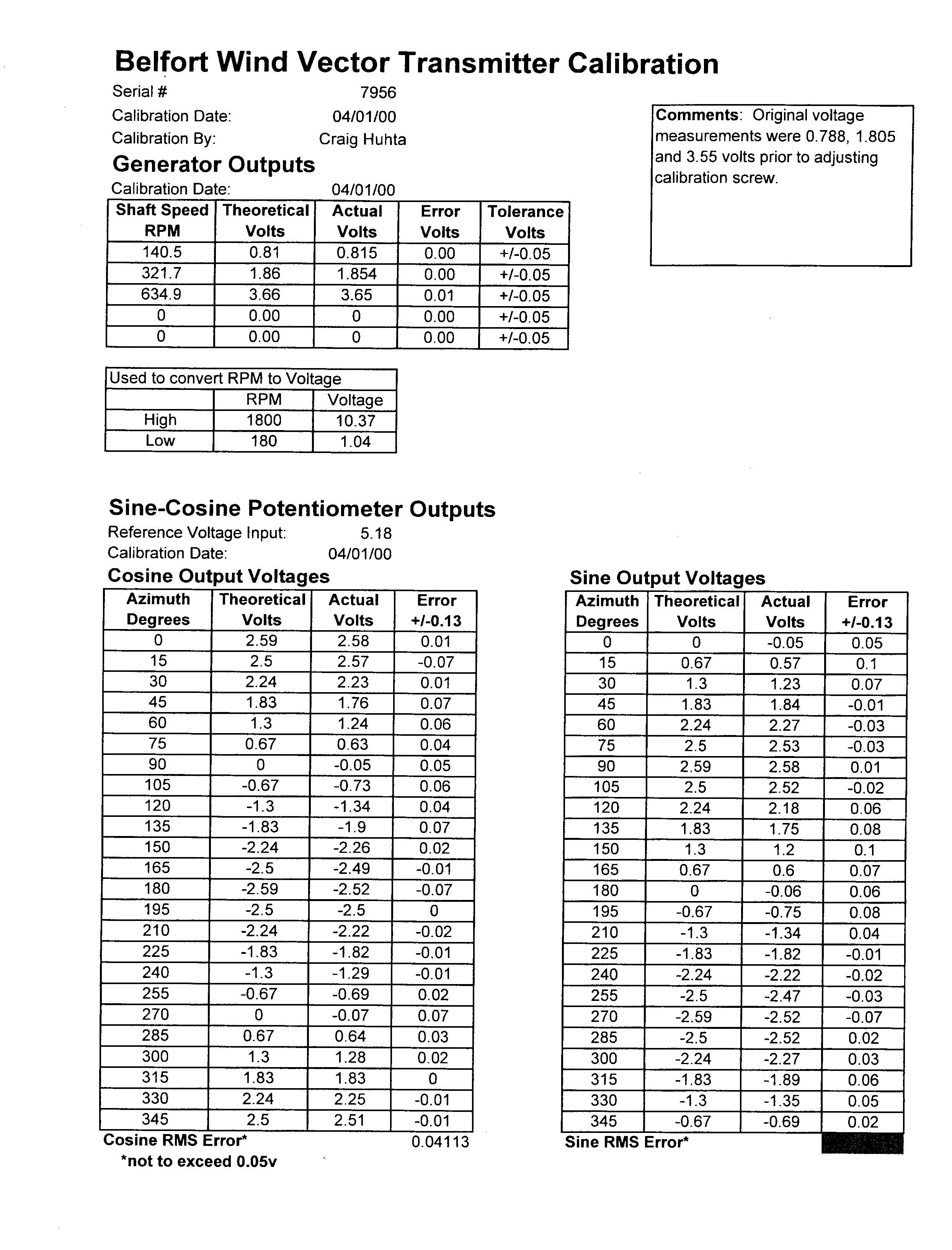
Port Anemometer |
Belfort 5-122AHD |
2133 |
4/12/01 |
collect |
|
Stbd Anemometer |
Belfort 5-122AHD |
7956 |
6/23/98 |
collect |
|
Barometer |
Atmospheric Instr. AIR-DB-3A |
7G3095 |
7/21/00 |
collect |
|
Mast PRR |
BSI PRR-610 |
9696 |
3/18/99 |
not collect |
|
UW PRR |
BSI PRR-600 |
9695 |
3/18/99 |
not collect |
|
Rel. Hum./Air Temp |
Rotronics MP-101A-C4 |
R45618 |
6/20/00 |
collect. |
|
Mast PAR |
QSR-240 |
6356 |
2/15/01 |
collect |
|
GUV |
Biospherical Instruments |
9228 |
3/15/00 |
collect |
|
P-Code GPS |
Trimble 20636-00 (SM) |
|
|
PCD/CIV |
|
Attitude GPS |
Ashtech 12 |
700273F2114 FW 7B13-D1-C21 |
|
collect |
|
Pyranometer |
Eppley PSP |
33090F3 |
11/7/00 |
collect |
|
Pyrgeometer |
Eppley PIR |
33023F3 |
7/23/98 |
collect |
|
Dry Air Temp |
R. M. Young 41342C |
2267 |
10/1/99 |
collect |
|
TSG |
SeaBird SBE21 |
218091-857 |
7/2/01 |
collect |
|
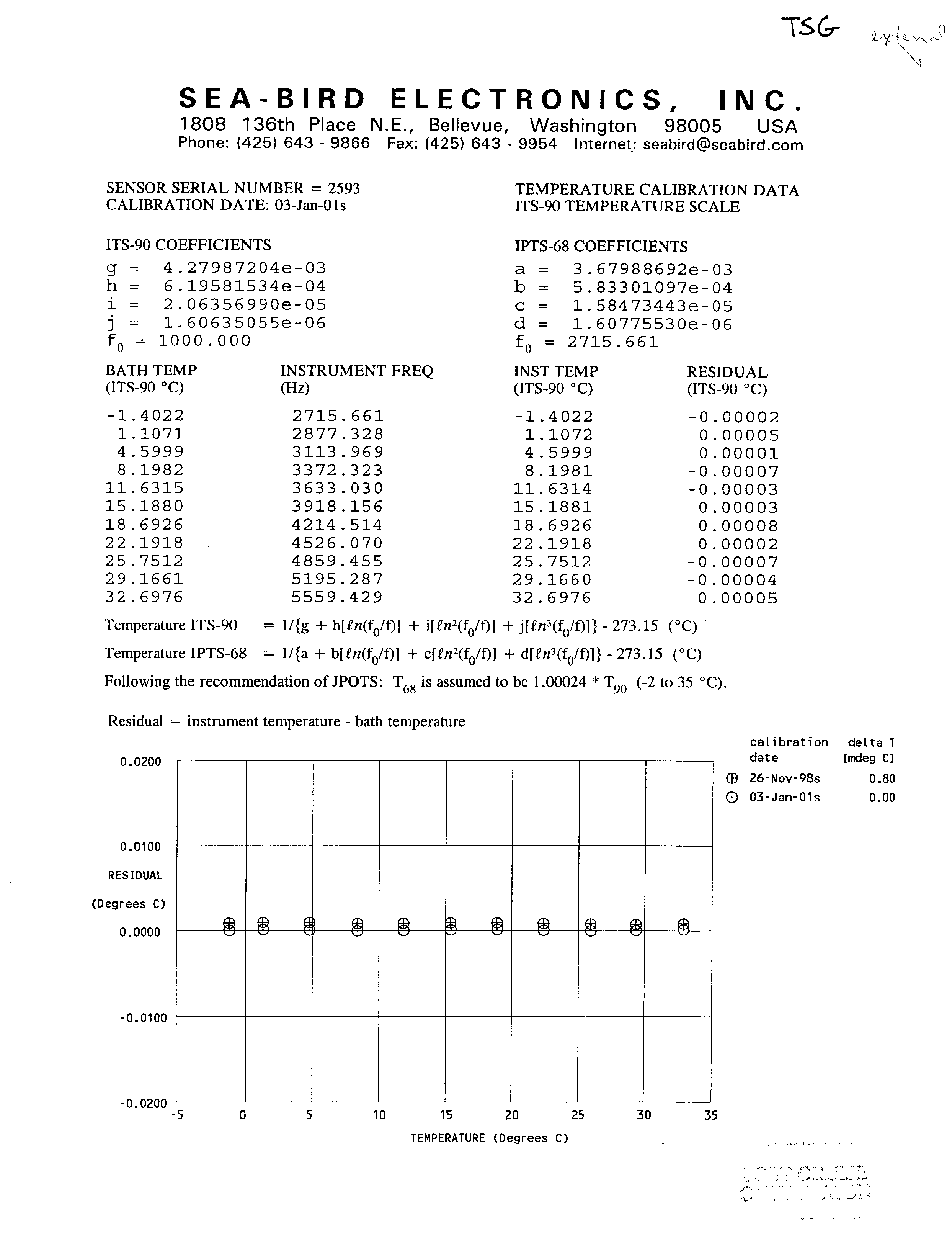
TSG Remote Temp |
SeaBird 3-01/S |
2593 |
01/03/01 |
collect |
|
Magnetometer |
EG&G G-866 |
|
|
off ship |
|
Gravimeter |
Lacoste & Romberg Gravity Meter |
|
|
not collect |
|
Bathymetry |
Simrad EK200 |
3001 |
11/1/95 |
collect |
|
Bathymetry |
Bathy 2000 |
|
|
collect |
|
Sensor |
Description |
|
CTD Fish |
SeaBird model SBE 9+ SN 09510716-0377, w/Paroscientific model 410K-105 pressure sensor SN 58949 |
|
CTD Deck Unit |
SeaBird model SBE 11+ SN 11P7536-0317 |
|
Primary Temperature Sensor |
SeaBird model 3-02/F SN 1457. Last cal 06/28/00. |
|
Secondary Temperature Sensor |
SeaBird model 3-02/F SN 1649. Last cal 06/28/00. |
|
Primary Conductivity Sensor |
SeaBird model 4-02/0 SN 1798. Last cal 06/27/00. |
|
Secondary Conductivity Sensor |
SeaBird model 4C SN 1431. Last cal 07/20/00. |
|
Dissolved Oxygen Sensor |
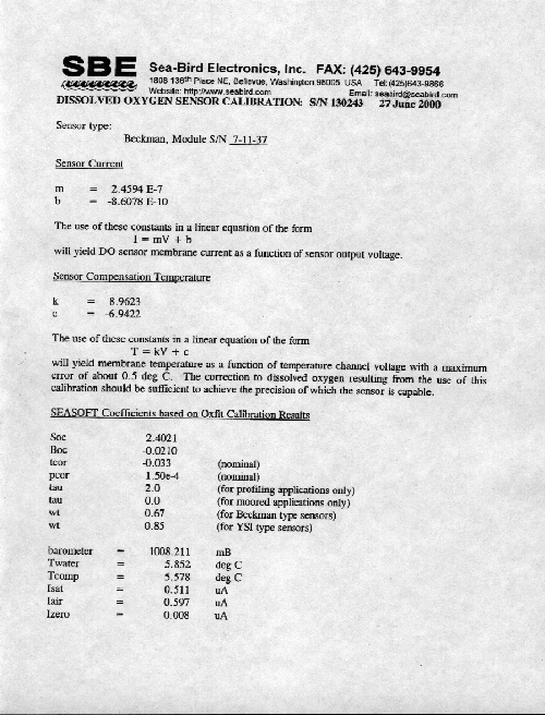
SeaBird model 13-02-B SN 130243. Last cal 6/27/00. |
|
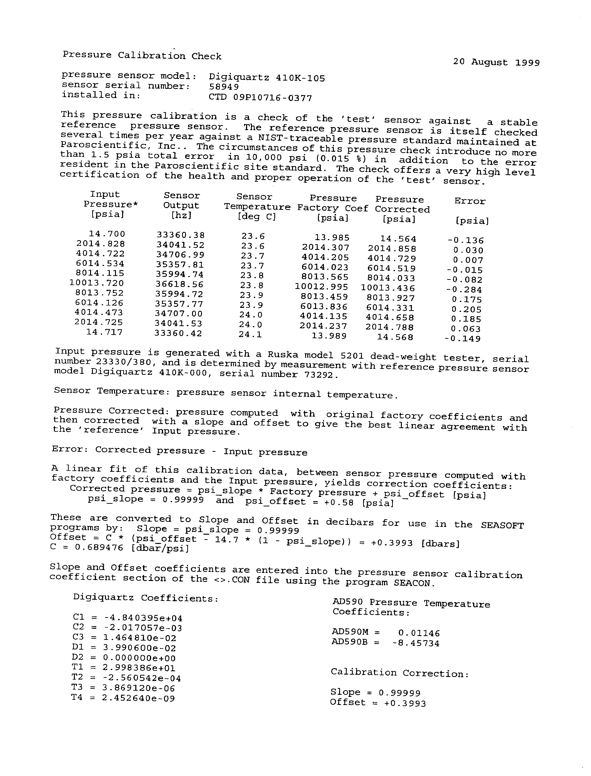
Pressure Sensor |
Paroscientific 410k-105 SN 58949. Last cal 8/20/99 |
|
Underwater PAR Sensor |
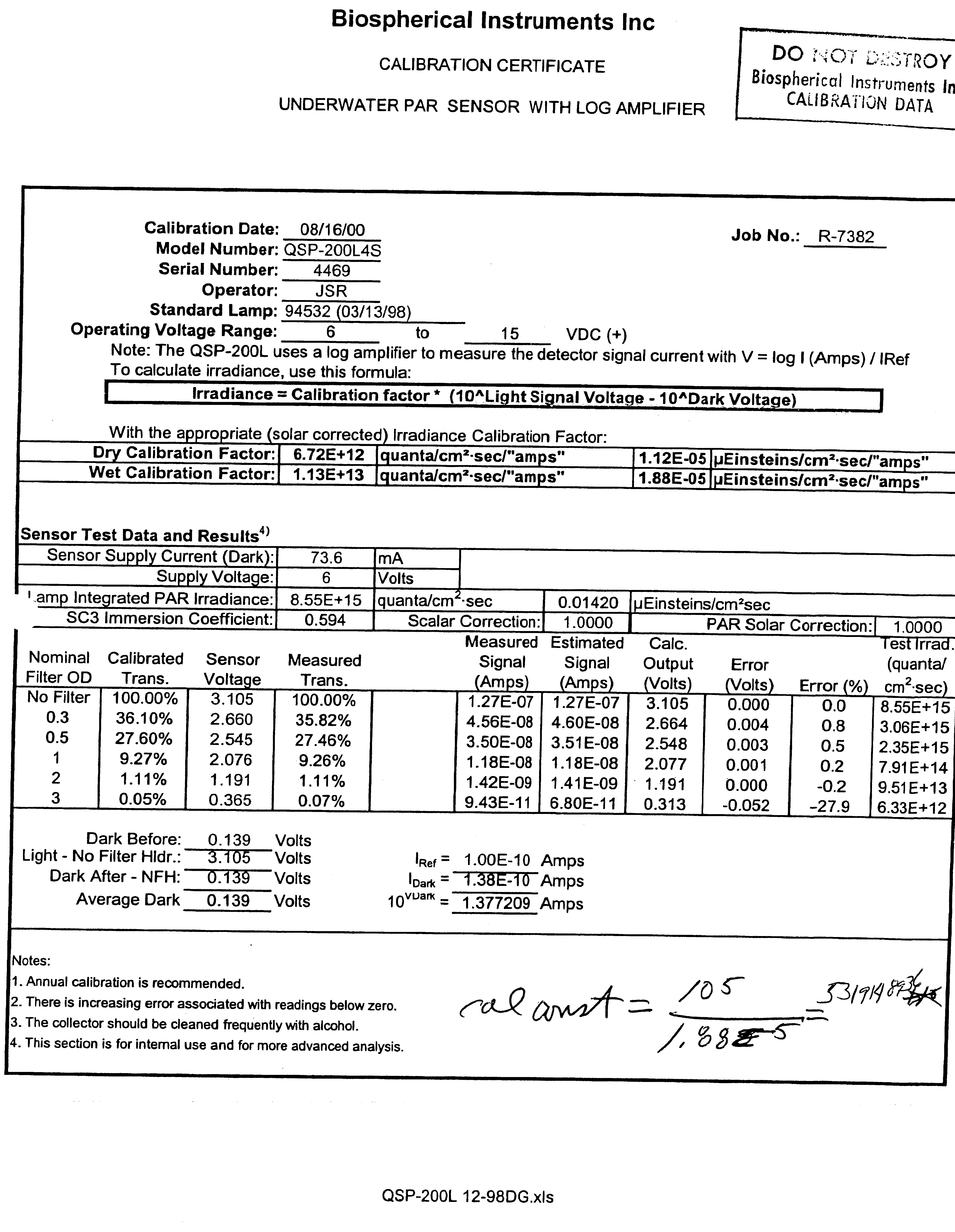
Biospherical Instruments QSP-200L4S. Last cal 8/16/00 |
|
Underwater PAR Sensor |
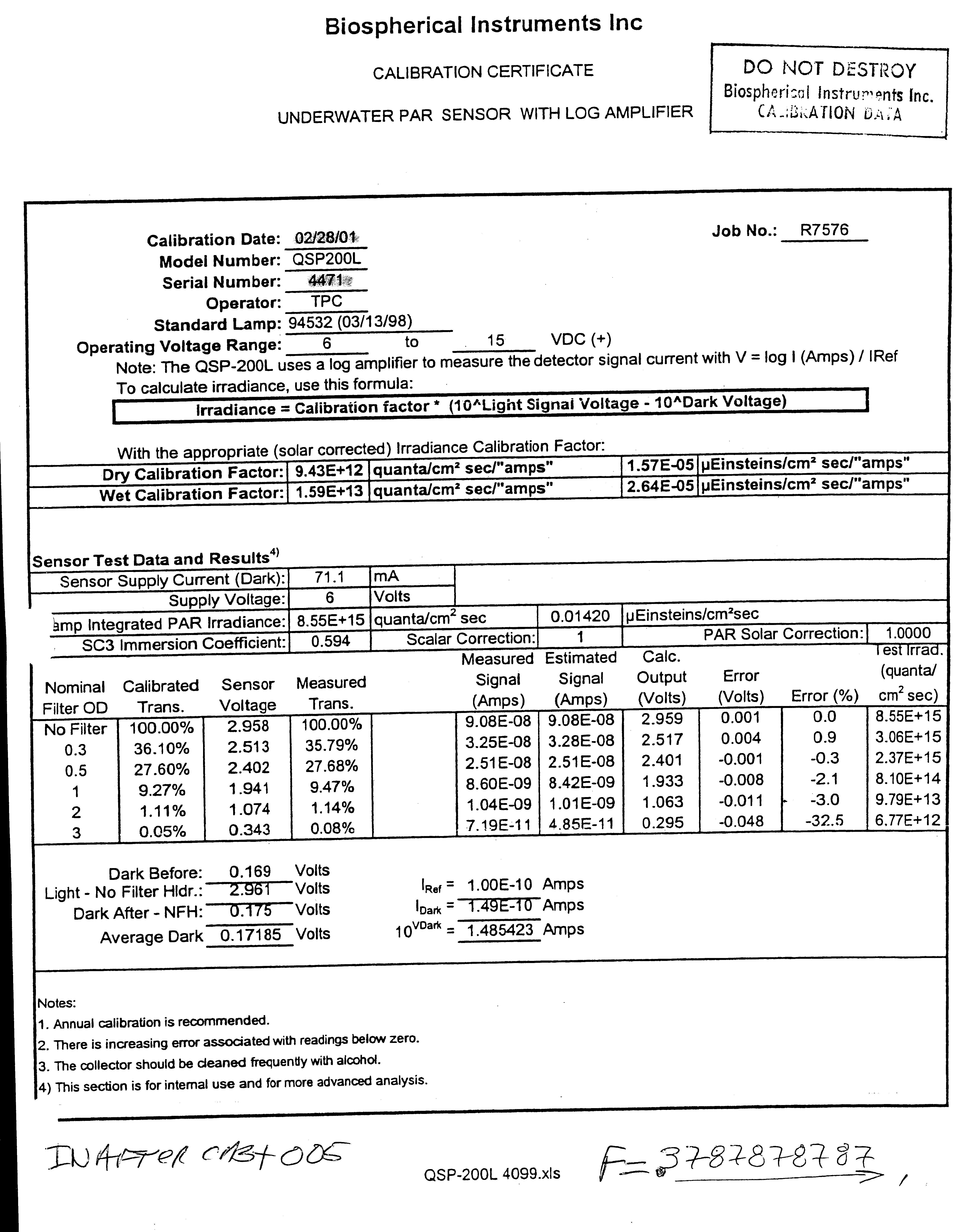
Biospherical Instruments QSP-200L4S. Last cal 2/28/01 |
|
Transmissometer |
Sea-Tech 25cm 474 (2000m). |
|
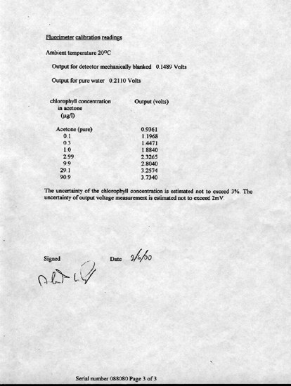
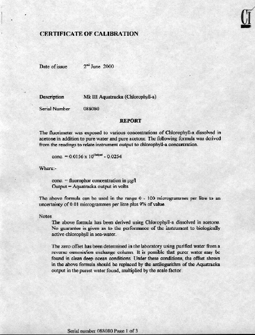
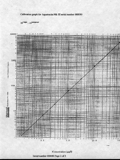
Fluorometer |
Chelsea model Mk III Aquatracka SN 088080. Last cal 6/2/00 |
|
Sensor |
Description |
|
Microcat |
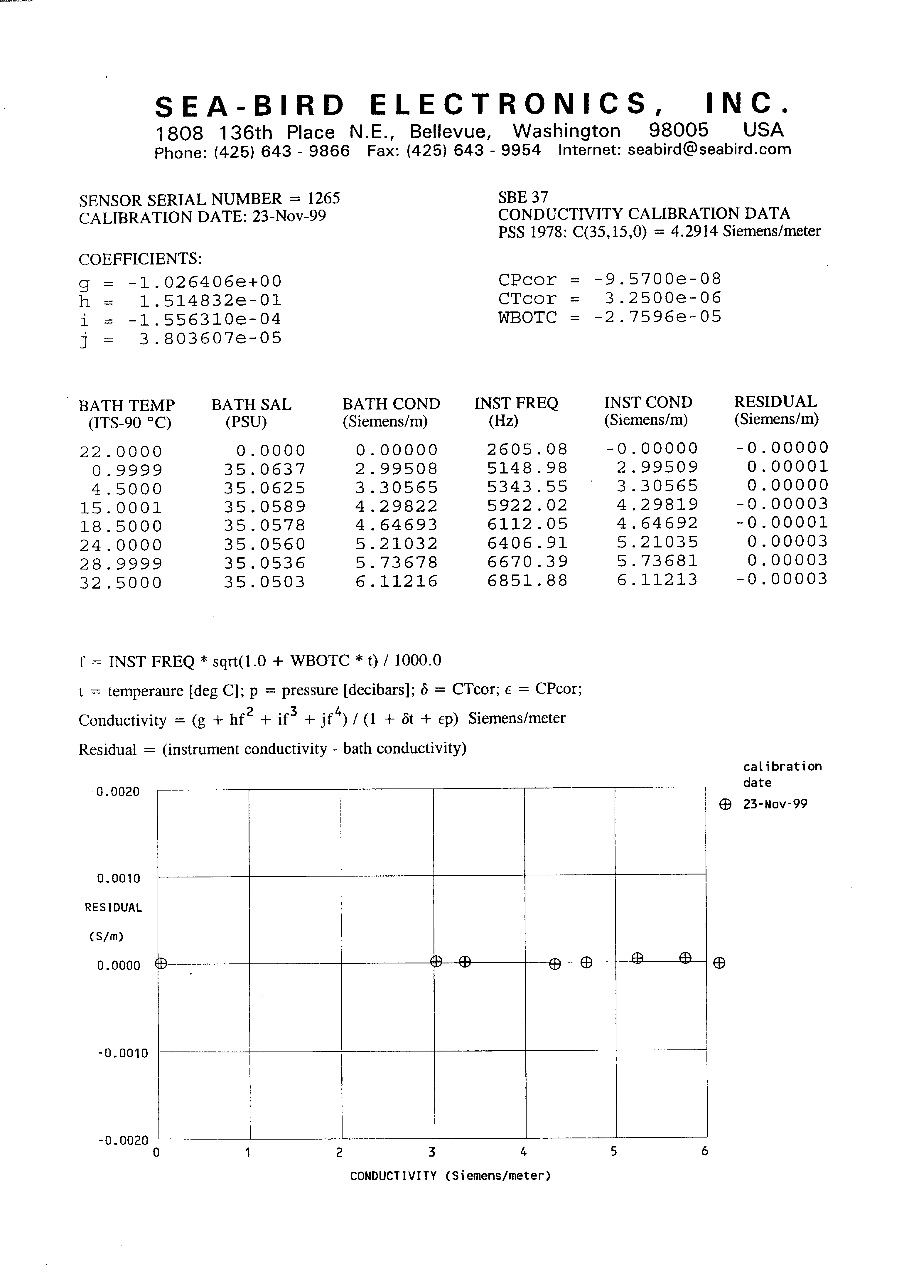
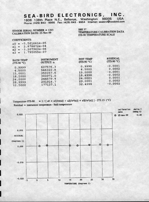
SeaBird model 37-SM 1024M SN 1265. Last cal 11/9/99 |
|
Sensor |
Description |
|
Pressure Sensor |
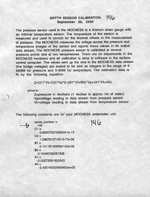
BESS Moc01 SN 0925. Last cal 9/30/00 |
|
Temperature Sensor |
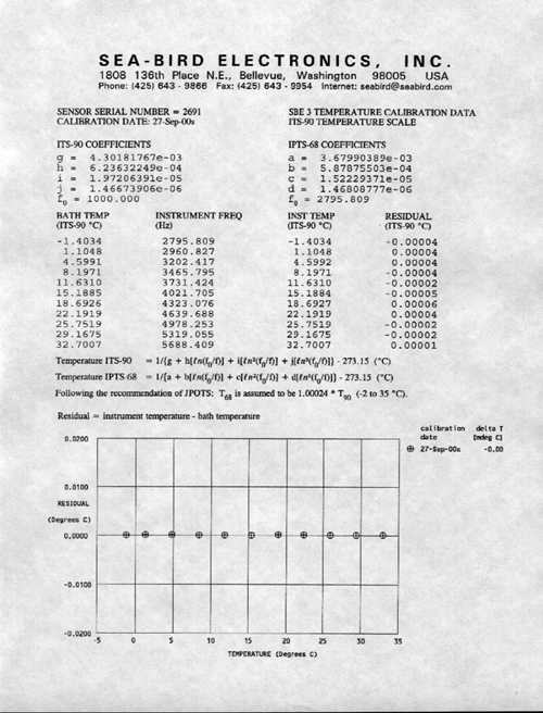
SeaBird model 3-01/S SN 032691. Last cal 9/27/00 |
|
Conductivity Sensor |
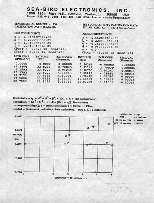
SeaBird model 4C SN 041850. Last cal 05/18/00 |
|
Transmissometer |
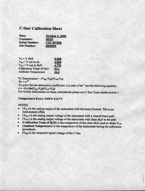
WetLabs model CST SN 397DR. Last cal 04/24/00. |
|
Dissolved Oxygen Sensor |
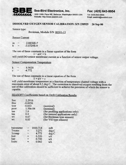
SeaBird model 13-02-B SN 230925. Last cal 09/26/00. |
|
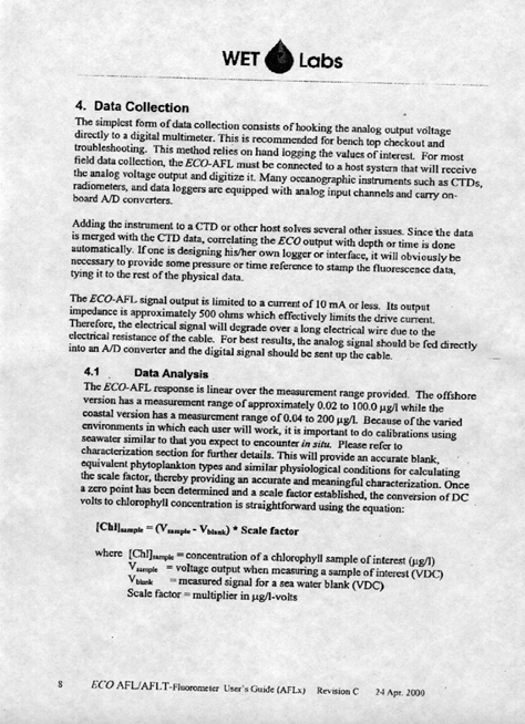
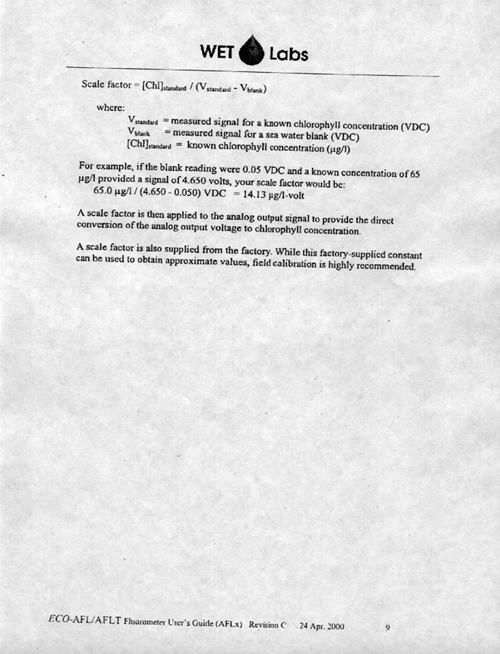
Fluorometer |
WetLabs model AFLT SN 99. Last cal 04/24/00 |
Acquisition Problems and Events
This section lists all known problems with acquisition during this cruise including instrument failures, data acquisition system failures and any other factor affecting this data set. The format is jjj:hh:mm (jjj is Julian day, hh is hour, and mm is minute). All times are in GMT.
|
Start Time |
End Time |
Event |
|
|
116 |
|
New Cruise NBP0103 – Argentina 200 Mile Limit: Turn on all logging. |
|
|
127 13:00 |
132 18:00 |
PIR batter failed. Batter replaced, instrument working again. |
|
|
130 16:38:56 |
131 |
PCODE GPS failed. Antenna fixed, GPS working again. |
|
|
140 20:00 |
|
Changed out port windbird for S/N 7956 |
|
|
|
154 18:15 |
End Data collection at Argentina’s 200 Mile limit. |
|
|
|
|
|
|
Belfort Wind Vector Transmitter
TransmissometerSBE 5T Submersible Pump Serial No: 050889
SBE 5T Submersible Pump Serial No:051265
Dissolved Oxygen Sensor Serial No: 130327
Conductivity Sensor (Secondary)
Temperature Sensor (Secondary)
Underwater PAR Sensor (1st five casts)
Pressure Sensor Pressure Sensor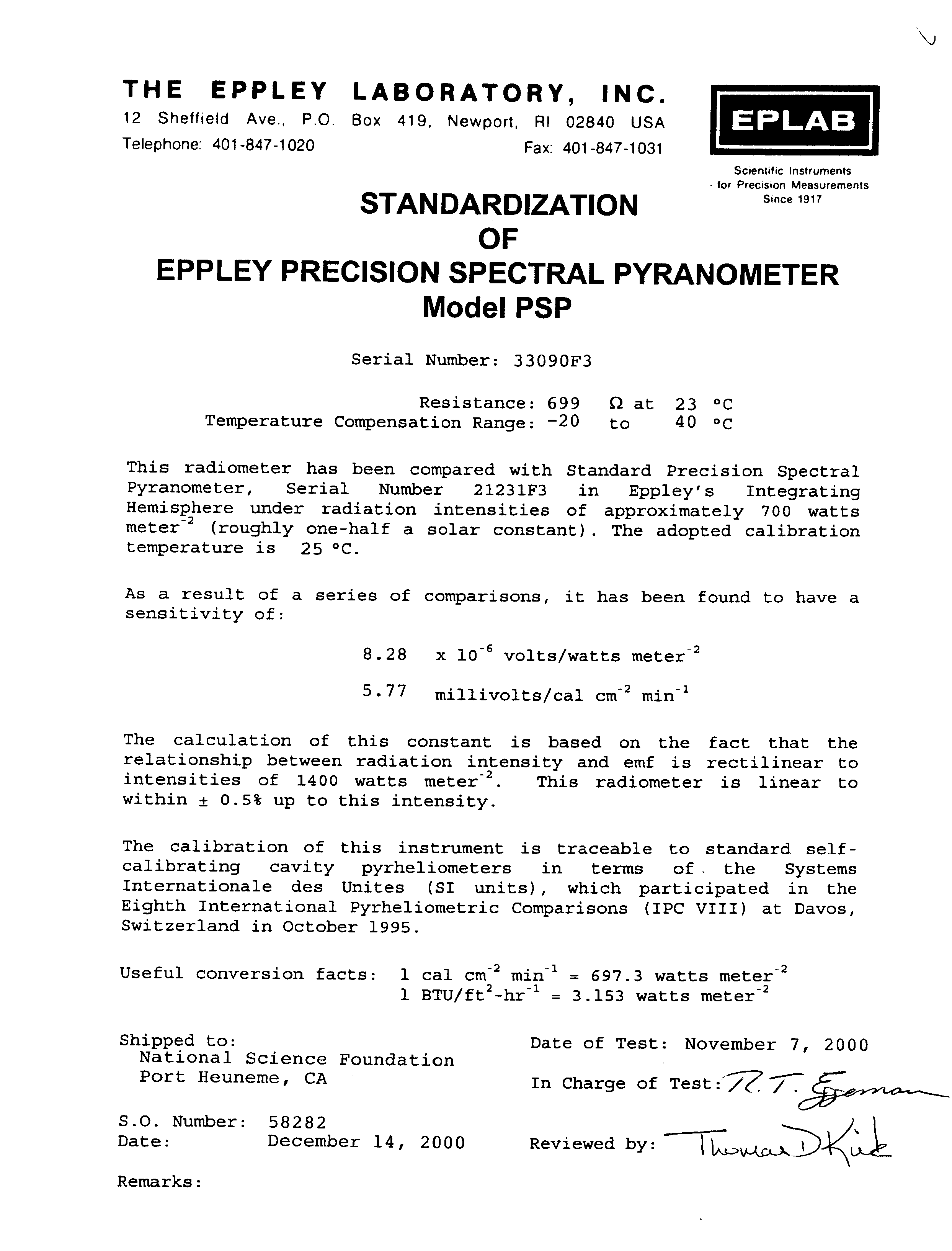