INVESTIGATORS:

Kenneth H. Brink
Woods Hole Oceanographic Institution, MS 21
Woods Hole, MA 02543
kbrink@whoi.edu

James D. Irish,
Woods Hole Oceanographic Institution, MS 17
Woods Hole, MA 02543
jirish@whoi.edu

Robert C. Beardsley,
Woods Hole Oceanographic Institution, MS 21
Woods Hole, MA 02543
rbeardsley@whoi.edu

GRANT PERIOD: October 1, 1993 - September 30, 1996
Scientific buoys systems are being made for the South Flank and Northeast Peak sites. Buoys are being refurbished for the guard moorings and Crest mooring. The scientific buoys are solar powered with GOES and ARGOS telemetry and ARGOS positioning. Sea Bird Temperature and conductivity sensors are mounted on an electro-mechanical cable at 5 meters intervals to 50 meters depth, and signals are digitized and stored in the buoy as well as telemetered to shore. The scientific buoys have air temperature, PAR (photosynthetically active radiation) and sea surface temperature. The Crest mooring also had an a load cell in the mooring cable for tension studies in 1995 (see below). Bio-optical packages (temperature, conductivity, transmissometer, fluorometer with data logger) were constructed and will be placed on the South Flank and Northeast Peak moorings at 10 and 40 meters depth and at the Crest at 10 m depth. Finally, a bottom package with Acoustic Doppler Current Profiler, temperature and pressure were constructed for the Southern Flank and Northeast Peak sites. The instruments are package in a trawl proof frame, with the ADCP in a locking gimbals.
The Long-Term Program moorings will be deployed in the fall (October), turned around on board ship in the spring (March) and recovered at the end of summer (September). The moorings will be refurbished in about one month and then redeployed for the next year. Moorings were deployed in fall 1994, and we propose to continue observations through summer 1999. The moorings outlined above will be phased in during the first three years, with the South Flank in 1995, the South Flank and Northeast Peak in 1996 and all three in 1997.
During all mooring cruises, supportive CTD (for sensor drift corrections), Shipboard ADCP, MET, etc. measurements are being taken and make available on our data base, or given to other to process and make available. Moored and shipboard data collected and reduced will be stored in the GLOBEC (a JGOFS type) of distributed, object oriented data base.
              ST1 - 40 52.0'N x 67 33.5' W in 75 meters.
              ST2 - 40 57.0'N x 67 37.3' W in 66 meters.
              LT1 - 40 58.1'N x 67 19.0' W in 76 meters.
Detailed PDR surveys were made of the proposed Northeast Peak site from the R/V Columbus Iselin (CI9405) in May 1994, and the proposed mooring location was to 41 24.4'N x 67 32.5' W. The two most likely Crest mooring sites were surveyed from the R/V Endeavor (EN256) in October 1994. The Crest mooring site was then selected as
LT2 - 41 24.4'N x 67 32.5' W in 38 meters.
The Southern Flank region from 50 to 120 meters (at both the Stratification and Long Term moored sites) is relatively smooth sand/gravel, with scallop dredge tracks visible in the sediments throughout the region. The top of Georges Bank on the Southern Flank side shallower than 50 meters has large sand/gravel ridges. The transition between the smooth and ridge topography is abrupt and located about 50 meters depth and takes place at about the location of the tidally mixed front in the summer. In the region of the Crest mooring site (about 40 m depth) the ridges are about 8 to 15 m in height. These ridges must have a strong effect on the current flow patterns in the region since they are up to 1/3 the water depth.
Testing elastic tether technology - The Crest mooring was deployed as a engineering test with elastic tethers in the mooring line to evaluate their performance in reducing stress and wear on the mooring. This mooring remained in place over the winter of 1994-95, and is still in position. No wear was observed on the mooring hardware from October through March. A load cell at the buoy attachment point indicated that mooring average tensions were normally 500 to 800 pounds, and did not exceed 1400 pounds during winter storms. High frequency, wave induced tensions variations were a few hundred pounds and were not a significant factor in mooring tension. Variations in tension due to the tidal velocities were several hundred pounds. The major weakness in the elastic technology is its susceptibility to being cut by fishermen, as was the Southern Flank Scientific mooring (which has been recovered and redeployed, and is recording data successfully again). This technology will be used on all Long Term Moored Program's scientific buoys.
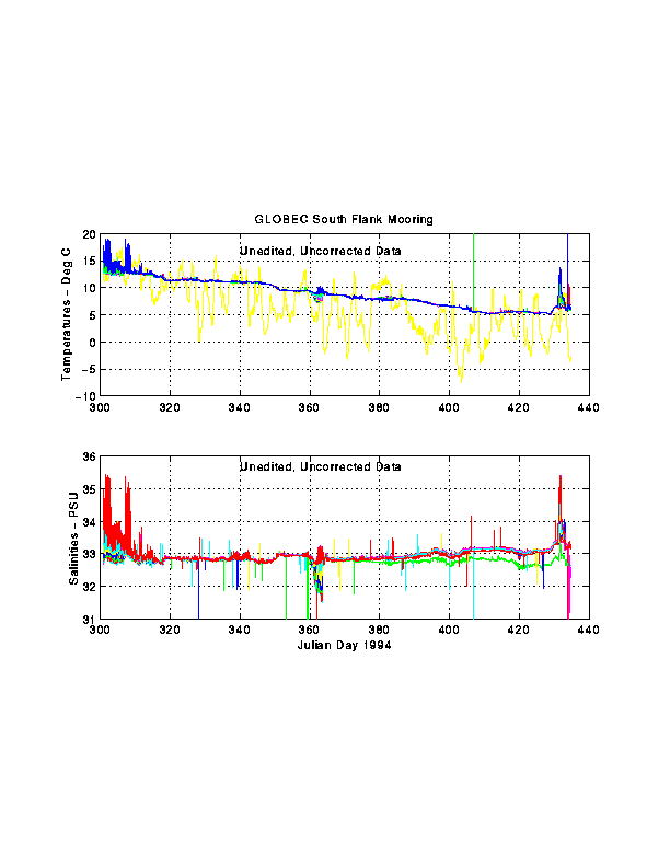
Moorings - The temperature and conductivity was measured at 5 meter increments on the Southern Flank Mooring. During the fall of 1994, a Warm Core Ring penetrated onto the shelf shallower than 75 m mooring. Warm water effects were again seen in March 1995. During the winter, the water was cooling and was well mixed in both temperature and salinity to better than 0.01 Degree C. A pulse of Scotian Shelf? water was seen in the upper 35 meters at the end of December 1994 (Julian Day 163), and again in mid-January 1995 (Julian Day 383). See attached figure for time series plot.
Shipboard hydrographic surveys - During all GLOBEC mooring cruises, hydrographic sections are taken from the crest through the shelf slope front regions through the Long Term Moorings as well as the Stratification Moorings. The water over the southern flank out to the shelf slope front was well mixed vertically (but with horizontal stratification across the bank) until the end of April. The stratification at the Southern Flank and Stratification moorings started with a storm about the first of May 1995.
Figure 1. Southern Flank moored unedited, corrected temperatures (top) and computed salinities (bottom). Temperatures - the record with the large variations is the air temperature 3 m above the water, and the smoother record is from temperatures at 1, 5, 10, 15, 20, 25 ,30, 35, 40, 45 and 50 meters. Salinities - the records are not corrected for drift, and are from sensor pairs at 5, 10, 15, 20, 25 ,30, 35, 40, 45 and 50 meters The high frequency signals seen throughout the records are due to the semidiurmal tides. The warm salty Warm Core Ring data is apparent in the first and last few days of the record. A fresher, colder water mass is seen coming through the area around JD363 in the upper 35 meters.