A Coordinated Response to the ENSO 1997-98
with Emphasis on Ecological Impacts
Summary of a Meeting held July 11, 1997 in San Francisco
U.S. Global Ocean Ecosystems Dynamics
July 1997
�Executive Summary
Since the early 1980's, there has been marked improvement in remote sensing and
modeling of El Niño's, such that it can be stated with some certainty that an El
Niño will occur in 1997-1998. The evidence available to date suggests that it
may be as strong or stronger than the 1982-83 El Niño. A group of
oceanographers, representing a number of west coast programs, and variety of
disciplines, met to develop a coordinated response of the research community to
examine the propagation and impacts of this El Niño along the Pacific coast of
the U.S. and Canada. The goal was to 1) provide a summary of ongoing and newly
funded research/monitoring along the Pacific coast; 2) identify critical types
of observations or specific regions where data are missing (gaps); and 3) provide
guidance for filling those gaps. Two major goals of an enhanced monitoring
program on the west coast are 1) to document the alongshore response of ocean
conditions as the El Niño propagates northward along the Pacific coast of North
America; and 2) to document the impacts of the anomalous conditions associated
with a major El Niño on the nearshore, coastal ecosystem of the Northeast
Pacific. Many of the research programs along the west coast are not directed
specifically at El Niño; however, a major 1997-1998 El Niño would impact ocean
conditions and ecological interactions along much of the west coast. Small
changes in focus, perhaps accompanied by small, incremental enhancements of
funds, could dramatically improve sampling at sites along the coast likely to be
impacted by El Niño. However, in no respect should these changes be viewed as
altering the fundamental long-term missions/goals of these established programs.
Four general needs of a coordinated ENSO monitoring effort are: 1) increased
sampling of subsurface observations; 2) broader sampling of ocean chemistry and
biology, including nutrients and multiple trophic levels; 3) sampling at many
locations along the west coast, at as high a frequency as affordable; and, 4)
establishment of a more effective communication network to coordinate the many
sampling and monitoring activities that occur along the west coast.
Generally, we are much better placed presently to document the physical
manifestation of El Niño conditions along the west coast than we are for
biological aspects of the ecosystem. The network of observation sites, including
moorings, NDBC buoys off California, tide gauges and shore temperature stations
at a number of locations, and survey transects and grids in place now is nearly
capable of documenting the physical manifestation of an El Niño as it propagates
poleward along the North American west coast. If the network is supplemented in
a few sites by a) beginning programs earlier than their intended starts, b)
continuing existing programs beyond their scheduled completion, or c) augmenting
existing programs, physical aspects of this prospective ENSO will be recorded
satisfactorily. The coastwide sampling outlook is not as favorable for nutrient
and biological variables. As for the physics, some improvement in chemical and
biological sampling could be obtained by beginning projects prior to their
official start dates. However, some regions do not have ongoing or planned
sampling of biology at all, nor are there research cruises ongoing to which
additional biological sampling could be added. In other regions it might be
possible to obtain additional biological sampling for minimal cost, because
research cruises are already taking place for other reasons.
�
I. Background and Goals
In 1982-83, the largest short-term climate anomaly of the 20th century occurred,
when a massive El Niño created warm temperatures and deeper thermoclines along
most of the coast of North America, from the equator to the northern Gulf of
Alaska. At the time, El Niño prediction and precursors were unreliable, and the
El Niño occurred unexpectedly. Consequently, with little warning, the research
community along the Pacific Coast, were unable to mobilize effectively to
document the propagation of the El Niño conditions from the tropics to the
extratropics and the effects of the El Niño on the ocean ecosystem. In the 15
years since the 1982-83 El Niño, great progress has been made in forecasting the
development of El Niño conditions. Much of this progress is due to three major
developments: 1) greatly expanded satellite remote sensing capability; 2)
improved ocean and atmospheric monitoring Pacific-wide, but especially along the
equator (TOGA-TAO array) where the El Niño conditions are forced and first
evident; and, 3) improved coupled atmospheric-ocean modeling that can project
temperature and ocean conditions 3 to 12 months ahead. Because of this progress,
we can state with some certainty that an El Niño will occur in 1997-1998.
Moreover, the evidence available to date, suggests that this El Niño may be as
strong or stronger than the 1982-83 event. Also, anomalously warm ocean
temperatures and high sea levels along the Pacific coast of North America during
March-June 1997 are likely due to local phenomena (anomalous Ekman pumping and
local winds), rather than the emerging El Niño. The consequences of warmer, less
productive conditions associated with a major El Niño, on top of already
anomalous conditions, could be disastrous for the marine life of the region.
Given the likelihood of a major El Niño propagating to the northern Pacific
extratropics in the fall 1997 to summer 1998 period, a group of researchers from
the west coast met in San Francisco for a one day workshop to discuss how to
develop a coordinated response to examine the propagation and impacts of this El
Niño event along the Pacific coast of the U.S. and Canada. Appendix 1 list the
researchers who attended the workshop. Table 2 provides the workshop agenda.
Two major goals of ENSO 97-98 Research
- Document the alongshore response of ocean conditions as the El Niño
propagates northward along the Pacific coast of North America--ideally to
distinguish locally forced from remotely forced changes. Critical to this goal
are measurements of surface, and subsurface, conditions at many sites along the
coast.
- Document the impacts of the anomalous conditions associated with a major
El Niño on the nearshore, coastal ecosystem of the Northeast Pacific�response
variables might include the distribution (perhaps northward shifts; range
extensions; exotics) of species, and the production of the ecosystem at several
trophic levels (primary, secondary, fish, birds, etc.).
�II. Ongoing or Planned Monitoring of Ocean Conditions along West Coast
Three speakers described the large scale view of ENSO and the impacts of El Niño
on the ocean ecosystems of high latitudes.
Using a computer animation, Howard Freeland provided an overview of the
high-latitude ocean conditions from 1981 to the present, and used the 1983 and
1992 El Niño events as examples to demonstrate the impacts of El Niño on
temperatures in the North Pacific. For both of those El Niño's, SST off of
British Columbia were ca. 2-2.5°C above normal. Long-term records of nutrient
concentrations along Line P, from the Strait of Juan de Fuca to Station P, show
that the region of low wintertime nitrate concentration has expanded further
offshore in recent decades. This has occurred independently of El Niño's and may
be a response to the longer term "regime shift" that occurred in the North
Pacific. The significance of the lower wintertime nitrate concentrations is that
springtime primary production reduces the concentration to limiting levels over a
much larger region of the North Pacific now than in earlier periods. Changes in
the thermal structure and mixed layer depth associated with the El Niño at
mid-to-high latitudes could reduce production even further.
Biological impacts of the 1983 El Niño were large. For instance, during non-El
Niño conditions, 80% of Fraser River Sockeye salmon normally return via the
southern route around Vancouver Island, BC. During the 1983 El Niño however, ca.
80% of the salmon returned by the northern route. Moreover, during the warm
conditions of the early 1990s, mackerel populations were much further north than
usual. Mackerel are predatory on essentially everything that they can physically
consume. Mackerel sampled from Barkley Sound in the 1990's had 5-8 juvenile
salmon in their guts. Survival and return of salmon from hatchery releases in
western Canada declined from ca. 5% (before the warm 1990's) to ca. 0.02%--a
major decline.
Ed Harrison provided an overview of the large scale temporal-spatial developments
of the last four major El Niños (1977, 1983, 1988, 1992). It is clear that the
different ENSO's have different temporal-spatial SST anomalies, and that there is
no single "typical El Niño".
Tim Liu showed a sequence of images (and a movie) from the NASA Scatterometer
that indicated two marked events of westerly winds in the western equatorial
Pacific in the last few months, and showed how those anomalous winds resulted in
a wave of sea level (from TOPEX) and sea surface temperature anomalies (from
AVHRR) that progressed from west to east along the equator in the Pacific.
Mark Abbott noted the need for broad and expansive spatial coverage--both from
satellites and in situ observations, especially subsurface)--to document the
progression of El Niño conditions from the eastern tropical Pacific to the
extratropics in the Northern Hemisphere.
Tom Powell described briefly the projects (PI's and titles) that were funded
recently by NSF and NOAA to begin the U.S. GLOBEC NEP program. Three in
particular are relevant to monitoring ocean conditions:
- Strub et al: Remote sensing of the Northeast Pacific: retrospective and concurrent time series analysis using multiple sensors on multiple scales
- Weingartner et al.: Physical-chemical structures, primary production and distribution of zooplankton and planktivorous fish on the Gulf of Alaska shelf: a GLOBEC monitoring proposal
- Smith et al.: Pilot monitoring off Oregon for climate change studies in the Eastern North Pacific. More specific details about these projects is provided below.
Powell emphasized that efforts to provide more comprehensive and coordinated
sampling of the impending ENSO by NEP-GLOBEC were not a redirection to become an
"ENSO impacts" program. The mission of the NEP program is to sample the physics
and biology of the region at ALL space and time scales. El Niño is a dominant
signal in the spectrum, and the program should, to the extent feasible, prepare
to sample the one expected later this year and next. Similar arguments hold for
other supported science programs (PNCERS, etc.) in the region--namely, that these
programs are not detouring from their fundamental goals to study El Niño.
Tom Weingartner provided additional details about their recently funded U.S.
GLOBEC monitoring project on the Gulf of Alaska shelf (the Gulf of Alaska (GAK)
line off Seward). Their project will be sampling the hydrography, velocity
fields, nutrients, phytoplankton, zooplankton and fish along the GAK line on six
cruises per year--determined to coincide roughly with biological seasonality
(e.g., spring bloom, salmon outmigration, etc.). Sampling will occur from very
near shore to ca. 150 km off shore. Sampling is not scheduled to begin until
March of 1998, and the question arose--Is there some way to begin the funding
early to enable sampling the fall and winter conditions this year prior to the
projected arrival of the peak of the El Niño conditions? According to
Weingartner, shiptime is available. It was also noted that eddies are spawned
off Yakutat and Sitka and propagate westward in strong El Niño years. It might
be possible to use the TOPEX altimeter to track these eddies if they form this
year.
Jack Helle reviewed the data collection/surveys that are being conducted by the
Ocean Carrying Capacity (OCC) program. Although the abundance (catch) of salmon
is at historic highs in Alaska in recent years, the individual weights of the
fish in 1994 have declined (long-term trend) ca. 40% (in some species and stocks)
from the sizes caught in the early 1970's. Interestingly, the size of the 1995
and 1996 fish are significantly larger than the 1994 fish, raising the question
of why--perhaps there has been another "regime shift"? The OCC program will be
conducting surface trawling, using a chartered trawler, from mid-July to
mid-August in 1997, 1998 and 1999. Trawling is done from Dixon entrance westward
to the Aleutians. Similar trawling was done last year. This year, CTD's and
plankton sampling will be done in addition to the trawling. In addition to this
offshore sampling, the RV John Cobb will conduct fish and plankton sampling in
inshore regions of southeast Alaska.
Howard Freeland briefed the group on sampling that is ongoing in Canada. First,
he noted that DFO-AES (Department of Fisheries and Oceans-Atmospheric Environment
Service) has 16 buoys that have been collecting data routinely--some for as long
as ten years. That data is made available in near real time via a web site
(http://www.ios.bc.ca/ios/osap/dispwx.htm). The La Perouse program off Vancouver
Island will continue to sample south of Barkley Sound, which includes three
current meter moorings, CTD survey cruises every 6 weeks, and zooplankton
sampling. Adding phytoplankton sampling to the program is being considered. The
Institute of Ocean Sciences will continue its approximately quarterly monitoring
of hydrography and nutrients along Line P with cruises in Aug-Sept 97 and
February 98. The use of aircraft to drop AXBT's once per month along Line P is
under consideration. David Welch has a cruise that will sample out to Stn Papa,
then north along 145°W to Alaska. There may also be two moorings deployed along
145°W near the Alaskan shelf by the Canadians. These could be moved to offshore
of the GAK (Seward) line if it were clearly advantageous to do so.
Barbara Hickey discussed a variety of programs that are conducting minimal
sampling along the Washington coast. The MacArthur is conducting CTD/ADCP
surveys during the summers of 1995-98 along the northern coast of Washington as
part of the Olympic Sanctuary program. A single mooring was deployed in the
coastal zone off Willapa Bay for a year as part of an EPA/Sea Grant project, but
there are no moorings there now. There was additional sampling and moorings in
the estuary. A single mooring will be deployed off Willapa Bay for the Pacific
Northwest Coastal Ecosystem Research Program (PNCERS) next spring, but could be
deployed sooner if additional funds became available. PNCERS will deploy moorings
off Grays Harbor, WA and Coos Bay, OR in 1998 and 1999, but they will be located
in fairly shallow water (ca. 50 m isobath). There will also be additional
sampling conducted within the estuaries during that period. If additional funds
were made available, it might be possible to deploy the coastal moorings
sooner--perhaps as early as this fall--to capture the signal of the El Niño as it
progresses northward.
Mike Kosro described the sampling that Bill Peterson has been conducting along
the Newport, OR line since May 1996. Using a small vessel (daytrips only)
zooplankton (vertical and surface horizontal tows) and hydrography have been
sampled ca. every other week. The stations are located 1, 3, 5, 10, and 15 miles
from shore. According to Peterson, the spring transition in 1997 occurred early,
upwelling was strong, the spring bloom was large, and zooplankton populations
were abundant--until May. In May, there were strong and consistent anomalous
southwesterly winds, and upwelling shut down (and hasn't resumed in any
significant way). By mid-June, zooplankton populations were extremely low.
Local populations of the common murre have crashed; few chicks fledged this
spring, and adults are starving and washing up on beaches. This happened also
last year, when upwelling was also poor. The lack of zooplankton in the
nearshore will certainly provide for hard times and poor survival of Oregon
coastal coho salmon this year. It is important to note that none of this is
directly caused by the El Niño, the effects of which are unlikely to have been
felt yet at Oregon latitudes, but rather are caused by locally-driven phenomena
(e.g., anomalous winds; no upwelling). The cumulative impacts from an El Niño
superimposed on the already poor conditions could be disastrous for nearshore
marine species.
Kosro (and later Jeff Paduan) showed surface velocity data sets from
high-frequency (HF) shore-based radars, which could provide surface current data
at 1-2 km resolution out to 40-50 km from shore. It was noted that there are now
three HF radar systems that will (or could be) sampling the nearshore current
fields from just north of Point Conception (Libe Washburn), Monterey Bay
(Paduan), and Newport, OR (Kosro). Both Kosro and Paduan showed how the HF radar
data agreed reasonably well with satellite observations of ocean features
collected simultaneously, and with time series observations obtained from
moorings located within the field-of-view of the radar.
Jane Huyer and Bob Smith described the monitoring transects that U.S. GLOBEC has
recently funded. Transect lines will be sampled quarterly (January, March,
August and November) for hydrography, currents, chlorophyll and zooplankton.
Sampling could begin as early as September/November 1997 if shiptime could be
funded (the ship is available). Current plans are for multiple transect lines--a
northern line at Newport, OR and a southern line off Coos Bay, OR. This GLOBEC
project has arranged with NSF for two days of ship time in September to do the
line off Newport. Ship time would be available in November to do the Newport,
Coos Bay, and an additional northern California transect, if funds were
available.
�Francisco Chavez briefed the group on the sampling that is being conducted at
three stations every three weeks by MBARI in Monterey Bay and slightly further
offshore. In addition, there are two permanent moorings; one is at the mouth of
the bay in 1000 m of water, and the second 20 km further offshore (in 1800 m of
water). The hydrography, ADCP, nutrients and chlorophyll from the Monterey Bay
dataset, which encompass the period from 1989 to present, indicate that nearshore
data from within the Bay are not sufficient to document and describe the impacts
of El Niño's (a point noted also by Mark Abbott from satellite observation
analysis) because the nearshore zone can remain relatively unaffected while
regions further from shore are altered dramatically. To adequately document El
Niño impacts, additional data from further offshore are needed. Toward that end,
MBARI is supporting three large-scale monitoring cruises in 1997. The MBARI
survey grid is centered on CalCOFI transect line 67, and extends 400 km offshore.
Three cruises will occur next year as well. The MBARI large-scale cruises
contain little physical oceanography, and that aspect of central California
monitoring needs additional resources. Moreover, this MBARI effort lacks a
higher trophic level component (zooplankton, etc.), other than presently unfunded
efforts "piggy-backed" on cruises in the region. Jeff Paduan also noted that
there are a number of other research cruises in the region that could complement
the seasonal coverage, including a Naval Post-Graduate School education/teaching
cruise (July 1997), a Monterey Bay Marine Sanctuary cruise (August 1997), and a
NAVOCEANO cruise (September 1997), if they were coordinated properly.
Marlene Noble described the USGS moorings in northern/central California.
Currently, there are efforts in two regions: a transect extending across the
shelf from Santa Cruz (3 moorings with current meters, thermistors, and sediment
traps), and a planned deployment of three moorings on the slope off San Francisco
(near Farallon Islands). The former are scheduled to be pulled in August 1997,
but if there is a strong desire, could be redeployed at the same location (or
nearby) to provide current records prior to and during the El Niño.
Figure 1 shows a summary of some of the observation programs in place now or that
will be implemented in the near future to monitor ocean conditions along the
Pacific coast of North America. Each observational program is depicted by
letter; the observations being made at each site are summarized in Table 1.
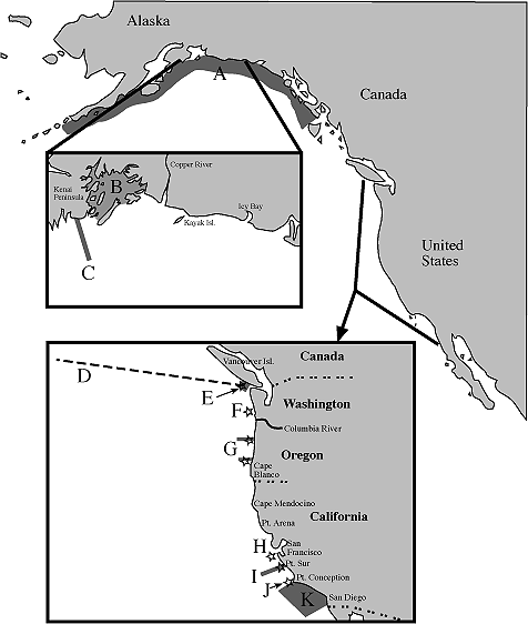
Figure 1. Locations of selected observation programs along the Pacific coast of
North America. A-K identify specific programs (see Table 1 and text for
additional details). Stars indicate locations with moorings. Shaded lines
indicate offshore extending transects. Shaded regions indicate locations with
survey grid sampling.
�
Table 1. Selected observational programs along the Pacific coast of North America.
Identifier in
Figure 1 |
Program/PI's | Frequency of Sampling |
Observations | Missing Obs./Needs |
| A | OCC/Helle et al. | annual survey in mid-July to mid-August |
juvenile salmon trawling, zooplankton, CTD, diet composition |
chlorophyll, nutrients, ADCP, hi-freq. acoustics |
| B | EVOS SEA/Cooney et al. | productive season cruises; one mooring? |
CTD, zooplankton, juvenile salmon, chlorophyll | |
| C | GLOBEC/Weingartner et al. | 6X/year along GAK line | hydrography, ADCP,
nutrients, chlorophyll, zooplankton, hi-freq. acoustics, trawling | doesn't begin till March 1998;
need earlier start, preferably November 97 |
| D | Line P/Freeland | quarterly cruises | CTD, ADCP, nutrients, chlorophyll, zooplankton? | |
| E | La Perouse/Canada | CTD survey every 6 weeks; several moorings |
CTD, zooplankton | nutrients, chlorophyll |
| F | PNCERS/Hickey | nearshore moorings off Gray's Harbor, Willapa Bay (and maybe Coos Bay, OR)
| temperature, currents | phytoplankton, zooplankton; needs to begin before scheduled 1998 start |
| G(1) | GLOBEC/Smith et al. | 5X/year, Newport and Coos Bay; moorings
| CTD, nutrients, ADCP, chlorophyll,
zooplankton | juvenile salmon trawling; need earlier start |
| G(2) | NMFS/Peterson | biweekly cruises nearshore at Newport
| CTD, zooplankton, chlorophyll, nutrients | fish |
| H | USGS/Noble | 3 moorings on shelf off Santa Cruz | currents, temperature, ADCP, sediment traps |
scheduled to end in August 1997; need turnaround and redeployment for another year |
| I | MBARI/Chavez et al. | quarterly cruises to 400 km offshore; nearshore moorings
| CTD, ADCP, nutrients, chlorophyll | zooplankton; offshore mooring; additional fall 1997 cruises; better physical observations |
| J(1) | MMS/Winant | 12 moorings N and S of Pt. Conception |
currents at several depths; temperature, salinity | scheduled to end in October 97;
need some turned around and redeployed for another year |
| J(2) | MMS/Washburn | HF coastal radar; hourly |
surface water velocities out to 40-50 km off Pt. Conception | |
| K | CalCOFI/Hayward et al. | quarterly survey cruise |
CTD, nutrients, chlorophyll, ADCP, zooplankton | |
III. A Coordinated ENSO Monitoring Effort
A. General Needs
Several general needs were identified as crucial in implementing a coordinated
effort to document the impact of the El Niño.
- increased emphasis on subsurface (to 500 m) observations--RATIONALE: satellite remote sensing provides a lot, but it cannot provide the subsurface data needed to examine changes in mixed layer depths, nutrient concentrations, etc. that could result from an ENSO event; many of these observations are very important to the biology.
- more emphasis on ocean biology, especially the concentration and distribution of nutrients and phytoplankton and the abundance, species composition and distribution of zooplankton--RATIONALE: biological and chemical variables are difficult to sample remotely (unlike moored physics platforms), and therefore, usually very undersampled relative to physics.
- need routine sampling at many locations along the west coast, at as high a frequency as affordable, to document the propagation of changes in physical structure and the impacts on the marine populations of the El Niño event--RATIONALE: thorough spatial and temporal sampling will be required in order to distinguish changes in the ecosystem that are locally forced (e.g. local winds/upwelling) from remotely forced (El Niño)
- more effective communication network is needed to coordinate the host of sampling and monitoring activities that occur along the west coast. At the least, a web page and listserver need to be established to ensure communication. The web page should be capable of handling near-real time data from diverse sources including satellites, shore stations, and remote buoys. Some of this is available already at JPL or other sites, but other data sources/types are not available electronically.
B. Particular Needs
The network of observation sites, including moorings, NDBC buoys off California,
tide gauges and shore temperature stations at a number of locations, and survey
transects and grids in place now is capable of documenting the physical
manifestation of an El Niño as it propagates poleward along the North American
west coast--IF ALL of the observations documented in Figure 1 and Table 1 are
obtained concurrently (i.e., be in the water) between now (July 1997) and
September 1998. Unfortunately, several of the efforts (esp. C, F and G) are not
scheduled to begin until early or late next year (thus missing the early stages
of the predicted El Niño), and several other efforts (esp. H and J) are scheduled
to conclude between August and November 1997 (missing most of the event
entirely). For the former, to the extent that it is feasible, survey cruises or
mooring deployments should begin now--before the El Niño's impacts are felt along
the coast. For the latter, efforts are needed to retrieve, service and redeploy
for another year some of the moored platforms�hopefully in the same location with
similar sensors at the same depths as previously deployed�so that pre-El Niño and
El Niño conditions are observed.
The coastwide sampling outlook is not as favorable for nutrient and biological
variables. As for the physics, some improvement in chemical and biological
sampling could be obtained by beginning projects prior to their official start
dates (e.g., C, G). Some regions do not have ongoing or planned sampling of
biology (e.g., F, H, J), nor are there research cruises ongoing which could
accommodate additional biological sampling. However, in other regions it might
be possible to obtain additional biological sampling (esp. zooplankton) for
minimal cost, because research cruises are already taking place (e.g., I).
Considering the sampling that is occurring already, we see the following
immediate needs (letter identifiers refer to sites in Figure 1 and Table 1):
- the region between Coos Bay, OR and Santa Cruz, CA has no ongoing monitoring of physics or biology
- juvenile salmon, and fish more generally, are better sampled in the northern region (via efforts A, B and C) than further south (except for maybe K); fish sampling should be done off Oregon
- high frequency acoustics--useful for sampling both fish and euphausiids, the latter a target species in the U.S. GLOBEC program--are used only in efforts B and C; some hi-frequency acoustic sampling on transects off Oregon would be useful
- nutrient sampling is spotty, being good in efforts C, D, G (part), and I, but absent elsewhere.
- some efforts (esp. moorings) will provide good data on ocean physics, but ocean chemistry and biology are undersampled or unsampled (e.g., F, H, J).
- zooplankton sampling is needed at more sites, especially at D (if not done already), F, and I
- observations are needed (or should be continued) at open ocean sites, like HOT and Stn PAPA, that have existing long-term records that include prior El Niño events
- establish the electronic communication resources (web pages, listserver, etc.) for timely communication of data (some near-real time) on ocean conditions (physics and biology) and ancillary data.
IV. Rapid Response Funding Opportunities
Judy Gray, NOAA's U.S. GLOBEC program coordinator noted that all of NOAA's U.S.
GLOBEC funds for NEP research were committed. Kendra Daly noted that although
there were no additional funds available in GLOBEC on the NSF side either, there
were two funding possibilities elsewhere in NSF. First, there is a regular NSF
proposal deadline on August 15, to which additional work in the NEP could be
proposed. However, the nature of the review process for regular proposals would
provide delays such that it would be unlikely that the funds would be available
prior to the arrival of the El Niño. Alternatively, NSF has SGER grants--Small
Grants for Exploratory Research. Up to ca. 5% of NSF core funds can be spent on
discretionary funds for rapid response events. SGER grants are not to exceed
$100K, and the duration of the award is usually one, but can be for up to two
years. SGER grants undergo an accelerated review process, and thus, might
provide funds in time to implement additional sampling of the El Niño. SGER
proposals are submitted to individual programs (e.g., Biological Oceanography)
and should be brief (2-5 pages), including a clear rationale for the urgency of
the proposed research, the nature and significance of its potential impact on the
field, and why the SGER grant would be a suitable means of supporting the
research.
�
Appendix 1.-- Workshop Participants
�Mark Abbott
Oregon State University
mark@oce.orst.edu
Hal Batchelder
Univ. California, Berkeley
halbatch@socrates.berkeley.edu
Steve Bollens
San Francisco State Univ.
sbollens@sfsu.edu
Mary-Elena Carr
Jet Propulsion Lab.
mec@pacific.jpl.nasa.gov
Francisco Chavez
Monterey Bay Aquarium Research Inst.
chfr@mbari.org
Kendra Daly
National Science Foundation
kdaly@nsf.gov
Elizabeth Dobbins
Univ. California, Berkeley
ldobbins@zanclopus.biol.berkeley.edu
Howard Freeland
Institute of Ocean Sciences
hjfree@ios.bc.ca
Judith Gray
NOAA Coastal Ocean Program
jgray@cop.noaa.gov
Ed Harrison
Pacific Marine Environmental Lab.
harrison@pmel.noaa.gov
John Helle
Alaska Fisheries Science Center
jhelle@abl.afsc.noaa.gov
Barbara Hickey
Univ. of Washington
bhickey@u.washington.edu
Jane Huyer
Oregon State University
ahuyer@oce.orst.edu
David Johnson
NOAA Coastal Ocean Program
djohnson@cop.noaa.gov
Mike Kosro
Oregon State University
kosro@oce.orst.edu
Tim Liu
Jet Propulsion Lab.
liu@pacific.jpl.nasa.gov
Marlene Noble
U.S. Geological Survey
marlene@octopus.wr.usgs.gov
Jeff Paduan
Naval Post-Graduate School
paje@mbari.org
Thomas Powell
Univ. California, Berkeley
zackp@socrates.berkeley.edu
Robert Smith
Oregon State University
rsmith@oce.orst.edu
Mark Stacey
Univ. California, Berkeley
mstacey@sagitta.biol.berkeley.edu
Tom Weingartner
Univ. of Alaska, Fairbanks
weingart@ims.alaska.edu
�
Appendix 2. -- Workshop Agenda
Informal ENSO response meeting.
11 July 1997. Westin Airport Hotel, San Francisco, CA

8:30	Welcome. Review agenda. Introduction. Aims.	T. Powell

8:45	Overview.	H. Freeland
9:05	Overview continued.	E. Harrison

	Individual presentations. Interest and capabilities.
	Each presentation should be 10 minutes, with 5 minutes for questions.

9:15	GLOBEC Northeast Pacific monitoring.	T. Powell

9:30	NASA satellite observations.	T. Liu

9:45	West coast satellite observations.	M. Abbott

10:00	BREAK

10:30	Gulf of Alaska.	T. Weingartner

10:45	Southern Alaska region	J. Helle

11:00	Queen Charlotte Is., Vancouver Is. coasts	H. Freeland

11:15	Washington coast.	B. Hickey

11:30	Oregon coast. I.	M. Kosro

11:45	Oregon coast. II./N. Calif.	A. Huyer/R. Smith

12:00	LUNCH

	Individual presentations (continued).

1:00	Central Calif./Monterey Bay	S. Bollens/F. Chavez/J. Paduan

1:15	USGS Work in Northern/Central California	M. Noble

1:30	Comments on Individ. presentations. Other regions, e.g.,
	comparisons to open ocean regimes, etc.
                                                "Open Mike".

	Agency perspectives. Facilities and resources.

1:45	NSF	K. Daly
	NOAA	J. Gray/D. Johnson
	NASA	M-E. Carr

2:15	Discussion. Focus: what is needed for coordination?

2:45	BREAK

3:15	Discussion. Coordination needs (continued).

4:00	Assignments. An incomplete list might include (but is not limited to) the following.
	Writing tasks, if any? Individual written items?
		Collective written materials?
	Ship, facilities coordination?
	Inter-calibration, -comparison of collected data?
	Communication: e-mail, web-site(s?), other?
	Additional People and groups to be included in future activities?
	Future meetings?
	Other?

5:00	ADJOURN