GLOBEC NEP/CCS Mesoscale Planning (2000)
GLOBEC NEP/CCS Mesoscale sampling plan. (Revised from information provided by Jack Barth, OSU, 13 April 2000)
Here are the latest sampling grids for the mesoscale and fine-resolution
surveys. At the bottom is a table of sampling lines with longitudes and
latitudes. Note that some of the inshore points may need to be adjusted
as we encounter the detailed bottom topography. Not included are
waypoints for turns in the north-south lines needed to avoid Cape Blanco
and Cape Arago, nor for the offshore, deep SeaSoar survey pattern NS lines.
Since R/V Wecoma is the only vessel towing continuously along these NS lines,
and because these waypoints will have to be adjusted given the local
bathymetry etc., I thought it best to leave navigation around these points
to each vessel. Click here to load a page with tables of waypoint coordinates in decimal degrees and degrees and minutes.
CCS Mesoscale survey
The mesoscale survey for the California Current System (CCS) region spans from Newport, OR to Crescent City, CA. U.S. GLOBEC research within this region in summer 2000 will occur on two cruises: 1) late-May to mid-June, and 2) late-July to mid-August. The Seasoar mesoscale survey is broken into two parts-an inshore part (red lines in figure) that will be the first cruise activity (requiring about 5 days) and an offshore part (green lines in figure) that will be done at the conclusion of the cruise (requiring about 3 days). This scheme is required by the necessity of changing the Seasoar tow-cable for offshore regions to sample water depths greater than ca. 120 meters. The inshore mesoscale region will be sampled from south to north, concluding on the Newport line. After the inshore mesoscale, there will be three fine-scale surveys done as shown in the next figure. Each fine-scale survey will take approximately 2 days, after which drifters released at the beginning of the fine-scale survey will be located and retrieved. Fine-scale surveys will be done from North to South (expected drifter trajectory). Currently, the plan in May-June is to do the Northern fine-scale grid, then the Southern fine-scale grid, and finally, to repeat the Northern fine-scale grid. In July-August, the mesoscale (inner and outer) surveys will be identical, but the fine-scale work will proceed North-South-South, so that the Southern fine-scale grid will be replicated. The third figure shows the locations of the stations along the Long-Term Observation Program (LTOP) transect lines. From North to South the lines are designated as 1) Newport Hydro (NH), 2) Heceta Head (HH), 3) Five Mile (FM), 4) Rogue River (RR), and 5) Crescent City (CR). Each line is overlain by a Seasoar transect. Click here for a table of LTOP stations.
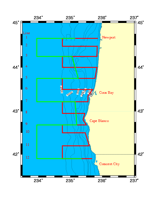
Figure 1. Mesoscale Seasoar survey track lines for inshore region (red lines) and offshore region (green line). Note that the green line overlays and obscures the red line for part of the transects. This provides a region of overlap between the inshore and offshore surveys, which will occur at the beginning and end of the research cruise, respectively. A gray-scale postscript file of this map is available by clicking here. Postscript files with only the inshore grid and offshore grid are also available.
Fine-resolution surveys
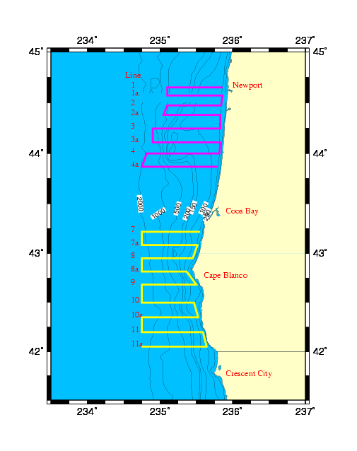
Figure 2. Fine-scale Seasoar survey track lines for northern fine-grid (purple lines) and the southern grid (yellow line). Grayscale postscript file of this by clicking here.
LTOP Sampling Lines/Stations.
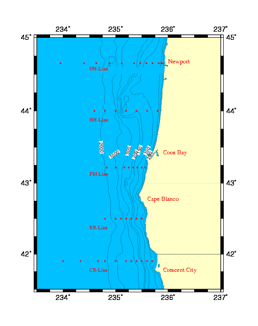
Figure 3. U.S. GLOBEC LTOP stations (red dots). Grayscale postscript file of this by clicking here.
This web site was last updated on 15 May 2000.
This page was last updated on August 17, 2000.
Maintained by:
Hal Batchelder
COAS
Oregon State University
Corvallis, OR 97331-5503
phone: 541-737-4500; FAX 541-737-2064