Cross-Frontal Exchange and Scotian Shelf Cross-over Workshops
10-12 October, 2000
Holiday Inn, Falmouth, Massachusetts

![]()
|
|
Cross-Frontal Exchange and Scotian Shelf Cross-over Workshops 10-12 October, 2000 Holiday Inn, Falmouth, Massachusetts |
|
Overview
Cross-Frontal Exchange
Presentations
|
Northeast Peak ADCP Data and Results from the Cross-Over Moorings C. Flagg (BNL), R. Beardsley (WHOI), and R. Limeburner (WHOI) Over the period of the Northwest Atlantic GLOBEC program, there have been a large number of cruises to the region of potential inflow onto the Northeast Peak from the Gulf of Maine and from the Scotian Shelf across the Northeast Channel. Shipboard ADCP data were collected during most of those cruises. The temporal and spatial coverage of the available ADCP data is shown in Figures C1 and C2. The processed data is available from GLOBEC ADCP web site: www.oasdpo.bnl.gov/mosaic/globec As is typical of all the current records from this region, the currents are dominated by tides and efforts are underway to detide the data both in the cross-over region and elsewhere. As part of the investigation of the source of low salinity water on the Northeast Peak, three moorings were deployed specifically for this purpose on the Northeast Peak of Georges Bank. The moorings augmented the long term Northeast Peak (NEP) mooring maintained by Jim Irish, and the four moorings on Browns Bank and in the Northeast Channel deployed by Bedford Institute of Oceanography. Nominally, the moorings were deployed in November 1998 and retrieved in August 1999. However, there were several significant winter storms which caused some of the moorings to either drag or loose their surface floatation. The moorings were re-installed as quickly as possible but there are some gaps, particularly in March, 1999. Two moorings were deployed on the northern flank of the Bank in 150 m (NFD) and 75 m (NFS) of water, while the third mooring was deployed on the southeast corner of the peak in 85 m (EF) of water (See Figure A1 for locations) Current meters and temperature/salinity sensors were deployed at all the sites; this short note describes only the temperature and salinity data from the three moorings, plus those from the NEP mooring, courtesy of Jim Irish. A summary plot giving the overall
impression of the temperature and salinity from the near surface Seacats is
shown in Figure C3. The most prominent
feature is the annual signal during which the near surface waters of the
Northeast Peak attain their temperature minima (<5oC) during
March at the same time that salinities for the area reach their annual maxima
(~32.8 psu). These annual extremes also
indicate that the Bank water densities also reach their maxima during March
with Aside from the long term behavior of the water properties, intrusions of low salinity water, primarily from the Northeast Channel area, are the dominant feature of the record. During much of the year, salinities less that ~32 psu on the Northeast Peak indicate the presence of water of Scotian Shelf origin. With that criterion, it is clear that there were extended periods of apparent Scotian shelf waters on the peak. Contrary to at least this authors' preconceptions, the transport of the low salinity Scotian Shelf water during 1998/1999 was not confined to the winter months of February and March. Rather, low salinity water appears to have penetrated past the 100 m isobath on the extreme eastern end of the Bank at the EF mooring during most of December, during mid-February, early March, early April, and from mid-April through most of May. Not all these events showed up at the other mooring site and never to such a degree in terms of salinity. The NEP mooring indicated four events where salinity dropped below 32 psu, brief events in mid-February and mid-April, a substantial event in mid-March that also showed up at the shallow North Flank mooring, and a two week event around the beginning of May. It is interesting to note that the large December low salinity event was completely absent from the NEP mooring, suggesting perhaps that low salinity water that makes it across the Channel during the late fall may be confined to the outer southern flank. In addition to the low salinity intrusions found near the surface, there were also some high salinity events, particularly at the EF mooring. These events were generally restricted to the near bottom 80m record except once or perhaps twice. The high salinity events occurred from late December thru May. In late February, the high salinity intrusion was clearly evident at the surface as well as at depth. It is also of note that many of the near surface low salinity intrusions at EF were accompanied by high salinity intrusions along the bottom. This suggests a rotation of the shelf/slope front perhaps forced by the low salinity Scotian Shelf water or perhaps some more distant forcing that serves to open the "gate" for the low salinity water to make its way onto the Bank. |
 t values of 25.9 kg m-3
relative their summer minima of about 22.5 kg m-3.
t values of 25.9 kg m-3
relative their summer minima of about 22.5 kg m-3.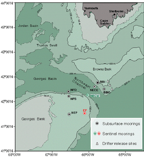